Could this be PDX's next bridge?
 A new span for the region would carry trains, walkers, bikers, maybe buses. No cars.
Friday, October 05, 2007
DYLAN RIVERA
The Oregonian Staff
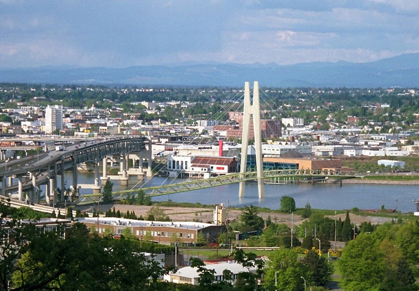
Portland's first new bridge in 34 years could be a 30-story, white monument climbing from the Willamette River into the skyline and standing in contrast to the many steel truss structures that define bridge city.
The span would carry light-rail and streetcar service, bicycles, pedestrians and possibly buses. But it would have no cars -- a testament to a generation that built one of the nation's most coveted transit systems.
The bridge would link downtown and OHSU, the city's largest employer, with OMSI, one of its biggest tourist and educational attractions, and with Milwaukie to the south. Carefully sculpted, the span could become a symbol of the region's aspirations as a national center for design and innovation.
"I don't think the Marquam Bridge does that," says Lloyd Lindley, a landscape architect and chairman of the Portland Design Commission. "What would make a great iconic bridge would be something that translates those qualities into something that's identifiable. It can be something as literal as Portlandia or as abstract as the Fremont Bridge."
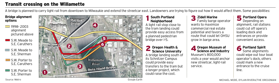
The exact route the bridge takes across the river is crucial to many riverfront interests -- there are at least five alignments now in play. The route could be set within the next three months. City Council and Metro hearings would follow until a final selection by July. Construction could start in 2011, with an opening in 2015.
That's a dramatically different situation from the last decade or so of wrangling over the light-rail line, money for which failed by a 2 percent margin in a 1998 referendum. Now, the bridge is part of an $880 million planned light-rail line from Portland to Milwaukie that got a big jolt when the Legislature committed $250 million earlier this year.
With money for a bridge within the region's grasp, planners are pushing landowners and businesses on both sides of the river to decide on a route.
"I think this can actually happen," Portland Planning Director Gil Kelley says.
Adding to the core
Aside from the overall goal of connecting the region's growing Southeast suburbs with downtown, Kelley says the bridge has a crucial role to play in Portland's core. It can link the Oregon Museum of Science and Industry, Oregon Health & Science University, Portland State and Portland Community College in what he calls a "science and technology quarter."
"Rather than have the river as a separator, this bridge has the potential to literally join the two banks," Kelley says. "To do that, it needs to be as low as it can possibly be, it needs to be as pedestrian- and bicycle-friendly as it can possibly be, and clearly be transit supportive."
City and regional officials in 1998 chose a route that would link OMSI with the RiverPlace area just north of the Marquam Bridge. A committee of design and civic activists picked a bridge type called a "cable-stayed" structure.
Popularized by the 1992 bridge in Seville, Spain, designed by Santiago Calatrava, cable-stayed spans have a tall column or set of columns tied to a bridge deck with a series of cables. The result often appears like a permeable fan of cables running from the tower's top out to points all along the bridge deck. The design they chose included a 380-foot tall center column, taller than downtown's Fox Tower office building.
Cable-stayed design
TriMet and Metro planners are contemplating a cable-stayed design and a normally less costly concrete segmented design, much like the Glenn Jackson Bridge, which ferries Interstate 205 over the Columbia River. But a segmented bridge could result in multiple columns dipping into the Willamette, disturbing salmon habitat more during construction and leaving more impediments to river navigation.
Metro and TriMet will settle on a bridge type during preliminary engineering, from September 2008 to September 2009.
Before the region picks a bridge design, however, nearby landowners are going to put it through an acrobatic test:
Can the bridge deck leap from ground-level near OMSI to a height of 72 feet above the river, to allow barge traffic? Then, can it descend on the west side in such a way as to remain high enough to clear a waterfront bicycle trail but dip low enough for a street-level station in South Waterfront?
And how well can a train ride up and down steep grades? The wheelchair-bound?
That's just the height issue.
Can the bridge meet the west bank farther south than the 1998 alignment, making for an easy transfer for OHSU employees from the light rail to the Portland Aerial Tram?
Most area landowners say the old route under the Marquam Bridge would not serve the South Waterfront area, which has gone from lines on a map in 1998 to a new high-rise neighborhood that continues to expand. Hundreds of residents have moved into condos, hundreds more units are under construction and 950 OSHU employees report to work daily at the university's first South Waterfront office tower.
OHSU has several more blocks to build on near the tram, and it plans an expansion to the north, on 20 acres donated by Portland's Schnitzer family.
"The way we look at it, the southern end of our property line in the Schnitzer Campus really is the center of our campus," says Mark Williams, OHSU's associate vice president for campus planning, development and real estate.
But that southern alignment could cut off land owned by Zidell Marine, says Bob Durgan, a real estate consultant for Zidell. The longtime family-owned company operates a barge building business on part of 33 acres it owns between OSHU's tram-area land and the Schnitzer Campus site.
Zidell would rather see the bridge touch down wherever it would help the city spur private-sector biotech development in the district, Durgan says. That would also generate tax revenue for South Waterfront's urban renewal district, which has ambitious goals for affordable housing, parks and riverfront wildlife habitat.
Thousands of future South Waterfront workers and residents -- not just OHSU's Marquam Hill employees -- need access to rail, Durgan says.
"It's about the transportation at the bottom of the hill, not the connection to the top of the hill," he says.
OHSU could build on Zidell's land and the Schnitzer site, Durgan says -- that might speed rail service to downtown, and still be within a third of a mile of the tram, according to TriMet estimates.
OHSU's Williams contends that a southern alignment, along what Metro refers to as Porter Street, serves the whole waterfront area, even south of the Ross Island Bridge. And it would leave Zidell with plenty of ripe development sites.
The southern push on the bridge's west end is already prompting planners to nudge the route to the south on the east end as well.
That could mean landing the east bank station a block south of OMSI, between 6 acres it recently bought and the Portland Opera's headquarters just to the south. Opera and OMSI officials say that's their preference.
Such a southern route could morph the bridge design into two columns of a lower height, TriMet officials said.
But what if that produces a zigzag line -- from the opera building to the southern route near the aerial tram? How much track and expense would that add to an already nine-figure project?
How much time would it delay Milwaukie-to downtown Portland commuters? And would it jeopardize federal funding?
Metro and TriMet say they'll have answers by springtime.
And their answers may determine whether the bridge itself is all about utility or also about creating another Portland icon.
Dylan Rivera: 503-221-8532;
dylanrivera@news.oregonian.com For environment news, go to
http://blog.oregonlive.com/pdxgreen


 Prev
Prev


 Linear Mode
