HomeDiagramsDatabaseMapsForum About
     

Go Back   SkyscraperPage Forum > Regional Sections > Canada > Alberta & British Columbia > Vancouver > Urban, Urban Design & Heritage Issues


Reply

 
Thread Tools Display Modes
     
     
  #241  
Old Posted Mar 6, 2009, 6:16 PM
djmk's Avatar
djmk djmk is offline
victory in near
 
Join Date: Sep 2008
Location: North Vancouver
Posts: 1,819
now correct me if i'm wrong, but i seem to remember (but i can not seem to confirm) that one of the reasons for the trouble of the waterfront stadium was because of the dangerous goods the trains may carry and its potential conflict with the stadium.

if this is true, how can they build office towers above the tracks?

edit: found something from the province
http://www2.canada.com/theprovince/news/story.html?id=d45ca4c9-75a5-46a5-8507-0a190f09c26a

to sum it up, the issues for not approve the stadium were


Quote

THE ISSUES WERE:

- Providing an adequate street network.

- Resolving the risks associated with dangerous goods in adjacent rail yards.

- Reconfiguring the stadium to ensure a better fit with heritage Gastown.

- Resolving impacts on the livability of residential areas south of the rail lands.

- Resolving impacts on future port development.
Reply With Quote
     
     
  #242  
Old Posted Mar 6, 2009, 6:38 PM
mrjauk mrjauk is offline
Registered User
 
Join Date: Oct 2008
Posts: 555
Quote:
Originally Posted by Lee_Haber8 View Post
I am shocked by the amount of space devoted towards parking

Why??? Long-term parking is probably the most inefficient use of land imaginable and to put so much of it on a site that is the best served by transit in all of BC boggles the mind!
I was there yesterday and spoke to someone from the CoV at length and he stressed over and over that this was a "conceptual plan", meaning that this is a view (of potentially hundreds) of what the place could like like. I would say that it's not written in stone, but it's not even written in sand, that's how provisional (and even provisional is too strong a word here) this conceptual plan is. It's more like a conceptual idea.

The end result will be determined by the CoV (as main facilitator, since they own no property here), the private owners of land in the area--Whitecaps owner Greg Kerfoot and the Cadillac-Fairview group most importantlly--and Canadian Pacific, which desperately wants to at least maintain (if not expand) the total track length it operates in the area.

So if you're upset about the amount of parking, make the city aware of your view as this process is just in its preliminary stages.

In addition, I asked about the possibility of putting up an iconic tower and was told that the site is view-cone protected (actually, the Granville Place tower, which is over 400ft tall, would not have been allowed that height had it been built under existing regulations), so the city would have to allow the builder a reprieve on that. Moreover, my interlocutor suggested that, in the event of a major building being built on that site, there would most likely have to be a very substantial residential component, otherwise it would be difficult to find the money (public or private) to build it.
Reply With Quote
     
     
  #243  
Old Posted Mar 6, 2009, 6:54 PM
twoNeurons twoNeurons is offline
loafing in lotusland
 
Join Date: Aug 2002
Location: Lotusland
Posts: 6,124
Quote:
Originally Posted by djmk View Post
now correct me if i'm wrong, but i seem to remember (but i can not seem to confirm) that one of the reasons for the trouble of the waterfront stadium was because of the dangerous goods the trains may carry and its potential conflict with the stadium.

if this is true, how can they build office towers above the tracks?

edit: found something from the province
http://www2.canada.com/theprovince/news/story.html?id=d45ca4c9-75a5-46a5-8507-0a190f09c26a

to sum it up, the issues for not approve the stadium were


Quote

THE ISSUES WERE:

- Providing an adequate street network.

- Resolving the risks associated with dangerous goods in adjacent rail yards.

- Reconfiguring the stadium to ensure a better fit with heritage Gastown.

- Resolving impacts on the livability of residential areas south of the rail lands.

- Resolving impacts on future port development.
I was thinking the same thing... hmmm...
Reply With Quote
     
     
  #244  
Old Posted Mar 6, 2009, 8:27 PM
officedweller officedweller is offline
Registered User
 
Join Date: Jul 2001
Location: Vancouver
Posts: 41,798
I think the parking that was referred to was the existing Granville Square parking, although there is provision in one or more of the Granville Street Extension plans for replacement parking (probably to compensate Granville Square for lost parking).

Quote:
Originally Posted by Hourglass View Post
Strangely enough, though, it seems to me that it might be better if the ferry piers were relocated to the front of the convention center expansion and the seaplane base to the east side of Canada Place. There's more room for additional piers as demand grows, and would mitigate some of the noise concerns from the residents of Coal Harbour (and yes, I know that relocating the piers to the west side of Canada Place might mean a longer hike for commuters taking the Seabus).
The landing area for the seaplanes is still over by Coal Harbour - that's a long way to taxi to dock. With the current configuration, I don't think the seaplanes cross the seabus or cruise ship paths (though I could be wrong), but with a relocated configuration, the seaplanes would either be taxing or taking-off or landing in high traffic areas.
Reply With Quote
     
     
  #245  
Old Posted Mar 6, 2009, 8:45 PM
Pinion Pinion is offline
See ya down under, mates
 
Join Date: Jul 2007
Posts: 5,167
As a daily seabus commuter it looks okay. I just hope there's some sunlight on the upper path to/from the seabus rather than walking a dark narrow path between large buildings (or walking underground).
Reply With Quote
     
     
  #246  
Old Posted Mar 6, 2009, 9:20 PM
officedweller officedweller is offline
Registered User
 
Join Date: Jul 2001
Location: Vancouver
Posts: 41,798
That raises an interesting question - will the concourse and Seabus passage be a "Fare Paid Zone" - so that entrances and exits are restricted?

If turnstiles are installed - would there be turnstiles at the entrance to each service (line) or to the concourse as a whole?
Reply With Quote
     
     
  #247  
Old Posted Mar 6, 2009, 10:32 PM
Mac Write Mac Write is offline
Registered User
 
Join Date: Dec 2008
Posts: 1,423
Seabus already has turnstyles.
Reply With Quote
     
     
  #248  
Old Posted Mar 7, 2009, 12:13 AM
Lee_Haber8 Lee_Haber8 is offline
Registered User
 
Join Date: Aug 2005
Posts: 757
Quote:
Originally Posted by Locked In View Post
What amount of space devoted to parking are you referring to? Are you referring to what exists now? I just flipped through the slides and the future plans heavily emphasize transit use over private vehicle use. The 'Land Use' slide talks about minimizing parking in new developments to discourage car use. The 'Challenges' slide points out that any Hub plan will require destruction of the Granville Street parkade, resulting in the loss of parking. All the slides hammer home how great the transit connections are at Waterfront, and how the site will be developed around transit.

Thanks for posting the link to the updated slides jlousa, and attending on SSP's behalf Those of us who can't be in Vancouver appreciate it. The concept looks great - I like that they refer visually to Potsdamer Platz repeatedly, and I would love to see our own (likely scaled down) version of that on the waterfront. It all seems very far away though - if the landowners/developers decide to proceed with this in 4 years (reasonable estimate?), it sounds like we'll see it built out around 2020.

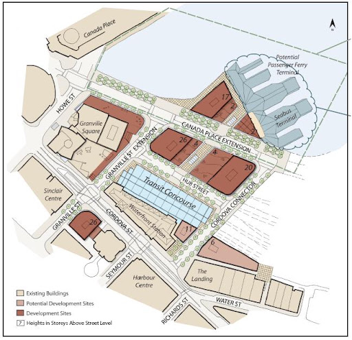
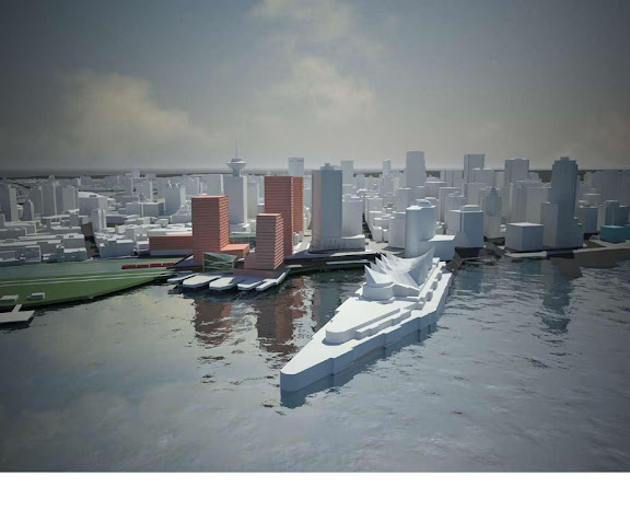
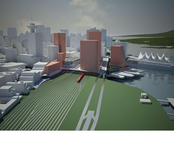
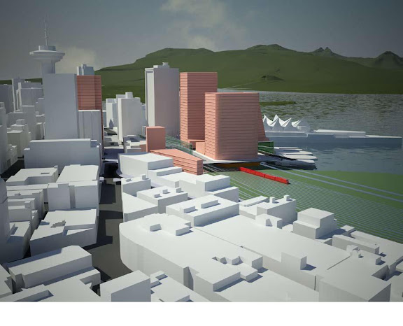
Here are some of the flashier renders from the 2009 Open House slides jlousa linked to on the COV's website ( http://vancouver.ca/commsvcs/currentplanning/whitecaps/presentationboards2.htm ):


I'm referring mainly to the 'Public Concourse' display, which shows several new parkades: two over the rail yards and one near the seabus terminal. I hope you're right about the city getting away from cars, so I would definitely appreciate it if you could clarify this.
Reply With Quote
     
     
  #249  
Old Posted Mar 7, 2009, 12:47 AM
Canadian Mind's Avatar
Canadian Mind Canadian Mind is offline
Registered User
 
Join Date: Aug 2006
Posts: 3,907
Quote:
Originally Posted by fever View Post
Looking at the section, the entrances to the seabus are kind of odd. Not a big deal and just a concept but whatever. I threw the ramps I was wondering about on there as well. Also just to see if it can fit, the grade of a canada line extension. Not sure which is more accurate but it doesn't look like it fits under the skytrain platform as is.
Why woudl you need a further Canada line extension? The station is already right there, and Seabus Serves the North Shore. Only way I could forsee a Canadaline extension is if you ran it along the WCE line to provide for far more frequent stops.

I also went through the Granville extension report. I fail to understand the point of the mid-level extension, aside from the fact that it will cost 1.4 million to 1.8 million than the other two options.

I like the high level option best because it provide the most spacious plaza, and doesn't screw around with the existing parkade to much (see more below). It also provides convinient pick-up and drop off points for people either heading to the hub or two one of the several new retail centres or office towers in the area, and my only gripe is that they may not be long enough, however, based on how the plaza is designed, they may be expandable in the future. It would also cause the least elevation change for Canada Place Way, which is only a plus in my opinion because frankly, walking uphill or downhill for a block isn't fun, even if the elevation change is only a few feet... It's mostly psycological, though I could see how it could present a phisical difficulty for those who have a disability. It would also provide for the most dramatic view overlooking the water, the Seabus Terminal, and Canada Place.

As for connecting with Cordova, Granville approaches as a 4 lane road, but through the plaza will only be 2 lane. I don't believe it would be too difficult or expensive to have 2 of Granville's 4 lanes follow the elevation of the mid and low level options to connect with Cordova, while the other two continue with the high level elevation.

Would be neat to see the whole plaza and roadway be made of level Cobblestone or Brickwork, give it a bit more of an aged feel. It would also eliminate any tripping hazard for people crossing the street. To actually mark where the roadway is I think decorative, protective pillars (like the things at entrances to shopping malls that can sop cars, forget what they are called) along either side of the road would be enough. If the speed limit is kept low enough for the block, say 20-30kph, there should be no problem with driviers mistaking the opposing lane for theirs, as at that speed it is easy enough to get to the right side if you are on the wrong side when a car is approaching.

Looking at the diagrams, I am wondering about the further plans to extend Canada Place Way, and I'm curious as to how and where they plan to integrate it with Waterfront Road.


Much to Jlousa's dislike, I still advocate having an intercity bus terminal integrated into the hub. My reasoning for this is that it will provide instant and convinient travel options for those arriving via intercity bus. Alot of people who use the bus are backpack travellers, basically those in their late teens and early 20s who can't afford to fly everywhere. They are the type who would get the most use out of the cities transit system to explore the area, rather than the buisness traveller who would simply rent a car at the airport, or the "richer" tourist who would take cabs everywhere or also rent a car.

As part of my liking of the high level option for Granville, Part of what I saw was potential to build the intercity bus station into the parkade area that would have been eliminated with the low and medium level options.

If this is not feasable, what are the engineering difficulties with building the bus station underneath Cordova, the concourse and station, and possibly part of the railyard? Would this be feasable? Or what about underneath the parking area by the helijet terminal?

Either way, I would hope the capacity would be greatly expanded compared to the current bus station, and the ammenities of the hub would far outshine the ones at the current bus station, like actual resteraunts to go to eat at while waiting for the bus. I imagine that the main entrance to the thing would be routed through Waterfront for buses comin from the east and south (most bus traffic from Seattle and inland BC), though I could see an entrance onto Canada Place Way or Cordova for tour buses, buses going up to the ski hills, and buses heading to Whistler, Pembroke, and to Horseshoe Bay Ferry Terminal.

Which brings up the last question, exactly how many shops, stores, and resteraunts will be integrated into the hub, or how much room is there for it? Would be nice to have a place to pick up a book, a place to go eat, and a place to actually buy tickets all within walking distance of eachother (of a traveller hauling a luggage bag around), perferably all under one roof.

Reply With Quote
     
     
  #250  
Old Posted Mar 7, 2009, 12:50 AM
officedweller officedweller is offline
Registered User
 
Join Date: Jul 2001
Location: Vancouver
Posts: 41,798
Quote:
Originally Posted by Mac Write View Post
Seabus already has turnstyles.
I was thinking more of when the ocra/octopus/oyster -type farecards come in - would you have to "exit" each line, then "enter" at the actual Seabus dock (where the existing turnstiles are located) or would it all be "within the turnstiles"?
Reply With Quote
     
     
  #251  
Old Posted Mar 7, 2009, 12:50 AM
nname nname is offline
Registered User
 
Join Date: Aug 2005
Posts: 5,105
Quote:
Originally Posted by Canadian Mind View Post
Why woudl you need a further Canada line extension?
To replace the SeaBus.
Reply With Quote
     
     
  #252  
Old Posted Mar 7, 2009, 12:57 AM
officedweller officedweller is offline
Registered User
 
Join Date: Jul 2001
Location: Vancouver
Posts: 41,798
Quote:
Originally Posted by Canadian Mind View Post
As for connecting with Cordova, Granville approaches as a 4 lane road, but through the plaza will only be 2 lane. I don't believe it would be too difficult or expensive to have 2 of Granville's 4 lanes follow the elevation of the mid and low level options to connect with Cordova, while the other two continue with the high level elevation.
I think the City hates anything that looks like a viaduct or ramp - because of the impact on the pedestrian realm. I think what you describe would be like the entrance to the Howe Street ramp to Granville Bridge - or like some of the ramps from the Alaskan Way Viaduct in Seattle. I can't see that happening.
Reply With Quote
     
     
  #253  
Old Posted Mar 7, 2009, 1:04 AM
Canadian Mind's Avatar
Canadian Mind Canadian Mind is offline
Registered User
 
Join Date: Aug 2006
Posts: 3,907
Quote:
Originally Posted by nname View Post
To replace the SeaBus.
I'd rather see a Skytrain Extension to the North Shore, and perferably it would go north Under Downtown, Stanely Park, and Burrard Inlet till you get to the North Shore, .

Though Skytrain over the treeline of Stanely park would be neat for the riders.

Quote:
Originally Posted by officedweller View Post
I think the City hates anything that looks like a viaduct or ramp - because of the impact on the pedestrian realm. I think what you describe would be like the entrance to the Howe Street ramp to Granville Bridge - or like some of the ramps from the Alaskan Way Viaduct in Seattle. I can't see that happening.
There is no reason for it to have a severe impact on the pedestrian realm. IF the two outer lanes go down to Cordova, hyou could have the sidewalks follow it, plus stay at the current street level to integrate with the plaza.

These ramps could also be made much shorter than the Howe Street Entrance ramps of the Alaskan Way Ramps in Seattle, since you only have a few feet between the different levels.

or just stick an elevator at the corner for people to use.
Reply With Quote
     
     
  #254  
Old Posted Mar 7, 2009, 2:29 AM
Locked In's Avatar
Locked In Locked In is offline
Registered User
 
Join Date: Aug 2008
Location: Vancouver
Posts: 1,977
Quote:
Originally Posted by Canadian Mind View Post
There is no reason for it to have a severe impact on the pedestrian realm. IF the two outer lanes go down to Cordova, hyou could have the sidewalks follow it, plus stay at the current street level to integrate with the plaza.

These ramps could also be made much shorter than the Howe Street Entrance ramps of the Alaskan Way Ramps in Seattle, since you only have a few feet between the different levels.
It will be more than a few feet - it will be 20 (at the crossing of the two streets, Granville is 153', Cordova at 134' - plus you have to fit a streetcar under there!) For the ramps to be the same grade that Granville is now, they'd pretty much have to start at Hastings.

I prefer the Mid-level or Low-Level plan. It provides a better connection between Cordova and the Granville extension (an actual intersection), doesn't involve overhead structures and ramps, and meets the Waterfront Station building at its base (rather than covering up half of it in the same way the current parkade does). I've seen at least 2 renders in CoV documents now of a Cordova-Granville intersection - I'm betting they don't want a viaduct over Cordava there.


Quote:
Originally Posted by Lee_Haber8 View Post
I'm referring mainly to the 'Public Concourse' display, which shows several new parkades: two over the rail yards and one near the seabus terminal. I hope you're right about the city getting away from cars, so I would definitely appreciate it if you could clarify this.
I've poked around the Hub slides and the Granville extension report a bit more (but I'm not sure what you mean by the 'public concourse' display - where is that?). The Granville extension allows for an additional parking level below the new viaduct in the mid-level plan to make up for current parking that would be lost - is that what you're referring to? However, the total amount of parking under both the mid-level and low-level plan decreases. In fact, it only increases under the high-level plan (see p.11 of the Granville extension report).

In general, both the Hub concept (as I pointed out above) and the Granville extension plan (see p.10) acknowledge that additional parking space is to be minimized, and that some current space may be lost. Vancouver certainly isn't 'getting away from cars', but these plans are a good example of commitment to transit-oriented development IMO.
Reply With Quote
     
     
  #255  
Old Posted Mar 7, 2009, 2:45 AM
jlousa's Avatar
jlousa jlousa is offline
Ferris Wheel Hater
 
Join Date: Jun 2006
Posts: 8,371
Don't forgot that you also have the loss of the parkade at Granville and Cordova which currently has 6 or 7 levels, any new building there would not come close to replacing all those lost spots. In the end you will end up with less parking then there is now so I don't see the issue on that.
The bus terminal will not be moved to Waterfront nor does it make sense to, it's tied in at Main St which is a hub in itself, Waterfront is a local hub while Main with the train station and bus station is more of the intercity hub, 2 different beasts.
Maybe we could get Translink to install a Zeppelin station in one of the towers, have another one in Central City, one in Coquitlam, another one in Lonsdale, it would definitely set us apart. I'm just kidding in case anyone acutally thinks that's a good idea. I do beleive Translink/COV are doing a great job on this and I think the fact they are putting in bike lockers and looking at end of trip facilities is really great (ie washroom/showers).
Reply With Quote
     
     
  #256  
Old Posted Mar 7, 2009, 4:07 AM
Rusty Gull's Avatar
Rusty Gull Rusty Gull is offline
Site 8 Lives
 
Join Date: Feb 2007
Location: Vancouver's North Shore
Posts: 1,285
Quote:
Originally Posted by djmk View Post
now correct me if i'm wrong, but i seem to remember (but i can not seem to confirm) that one of the reasons for the trouble of the waterfront stadium was because of the dangerous goods the trains may carry and its potential conflict with the stadium.
Totally and absolutely bogus.

I spoke with a transportation security expert on this issue -- he regularly consults for Transport Canada -- and he said in no uncertain terms that the anti-stadium crowd was trumping up that issue in order to achieve their Nimby agenda. (he said it in much more diplomatic terms, mind you).

Yes, there is the tiniest chance of something happening with dangerous goods, but as he noted, that risk also exists for the thousands of people who work, live and travel near Waterfront Station and the port lands currently.
Reply With Quote
     
     
  #257  
Old Posted Mar 9, 2009, 8:02 PM
officedweller officedweller is offline
Registered User
 
Join Date: Jul 2001
Location: Vancouver
Posts: 41,798
WRT additional parking - I can just see one or two of levels for the office buildings (depending on the site constraints) - you can't rent high end (water view) office space without any parking. The company executives who decide where to locate their offices aren't the ones who will take transit. That said, the existence of the rail tracks will limit the feasibility of parking options.

This board shows parking options, but I expect that those solutions (building under the tracks, mechanized systems) would be too expensive to implement. Of the two, a mechanized system may work, but with height limits in place, trading office space for parking space may not be a viable solution.

http://vancouver.ca/commsvcs/currentplanning/whitecaps/pdf/Board8_AccessCirc%20sm.pdf
Reply With Quote
     
     
  #258  
Old Posted May 28, 2009, 9:04 PM
Locked In's Avatar
Locked In Locked In is offline
Registered User
 
Join Date: Aug 2008
Location: Vancouver
Posts: 1,977
The Central Waterfront Hub Framework Document has been posted on the City's website (PDF, ~7MB). The purpose of the Framework is to "clearly establish the City’s vision for the area, to inspire other stakeholders, and to set parameters to guide future work towards the implementation of the vision". It will considered by Council's Standing Committee on Transportation and Traffic on June 2.

I haven't had a chance to go through the Framework itself, but I was emailed an accompanying policy report by the City (not sure where it's available online). During during my brief glance through the summary of consulation responses, a few points I thought might be of interest to people on here stood out:
Quote:
Hub Study Working Group... was supportive of the Hub concept, and expressed some common themes: ...

- Taller buildings than currently allowed under the City View Cones would be appropriate for the area and could help the project finances.

- Providing sufficient public open space in the area will be important.
and...
Quote:
The key themes raised in public responses from open houses held in March 2007, April 2008 and March 2009 can be briefly summarized as follows:

- Strong support for prioritizing pedestrian, cycling, and transit over private auto movement. Many respondents expressed a desire for a pedestrian-friendly environment, some for a pedestrian only environment. The importance of an extension of the seawall to the east was mentioned by many respondents.

- With respect to land use, comments indicated support for an extension of the downtown functions (office, commercial, entertainment, cultural) into this area but there was a mix of views on the appropriateness of residential, given the noise associated with the working harbour and rail yard and any possible new entertainment/commercial uses introduced to the area.

- A mixed response on the issue of building heights. Some respondents felt this is a good location for a landmark tall building and significant density, some felt the suggested heights are too high and block views or are inappropriate so close to historic Gastown.

- Many respondents commented on the importance of protecting the heritage buildings in the area, and don't want to see new development compromise those buildings, particularly Waterfront Station. Other comments encourage beautiful and/or bold architecture in the area, one suggests building "a cathedral to transit" and a "palace to sustainability".
Reply With Quote
     
     
  #259  
Old Posted May 28, 2009, 9:30 PM
Yume-sama's Avatar
Yume-sama Yume-sama is offline
Registered User
 
Join Date: May 2007
Location: Vancouver / Calgary / Tokyo
Posts: 7,523
Taller buildings than currently allowed, eh?

Bring on a supertall!!!

Never gonna happen, though, is it.
Reply With Quote
     
     
  #260  
Old Posted May 28, 2009, 9:33 PM
NetMapel's Avatar
NetMapel NetMapel is offline
Hello World
 
Join Date: Jul 2008
Posts: 1,580
Quote:
Originally Posted by Yume-sama View Post
Taller buildings than currently allowed, eh?

Bring on a supertall!!!

Never gonna happen, though, is it.
Too ambitious for Vancouver ! Think of all the shadow a supertall will cast :O
Reply With Quote
     
     
This discussion thread continues

Use the page links to the lower-right to go to the next page for additional posts
 
 
Reply

Go Back   SkyscraperPage Forum > Regional Sections > Canada > Alberta & British Columbia > Vancouver > Urban, Urban Design & Heritage Issues
Forum Jump


Forum Jump


All times are GMT. The time now is 6:27 PM.


Powered by vBulletin® Version 3.8.7
Copyright ©2000 - 2026, vBulletin Solutions, Inc.