HomeDiagramsDatabaseMapsForum About
     

Go Back   SkyscraperPage Forum > Regional Sections > Canada > Ontario > Ottawa-Gatineau > Transportation


Reply

 
Thread Tools Display Modes
     
     
  #201  
Old Posted Mar 25, 2022, 2:29 AM
Harley613's Avatar
Harley613 Harley613 is offline
Registered User
 
Join Date: Jun 2009
Location: Aylmer, QC
Posts: 6,896
Quote:
Originally Posted by J.OT13 View Post
As an Orleans resident, I'm also unsure that the Hunt Club extension is needed. Even more so now if commuting patterns are to change with a new hybrid work reality.

If it is needed, what if Brian Coburn and Hunt Club became one and not connect to Innes. As its own cross-town link, it doesn't need to directly connect to another. Someone who needs to take Innes from Hunt Club could take the Queensway, go up Anderson or Naven (or any other).
On this map the Brian Coburn extension meets the Hunt Club section before it meets Innes, allowing you to choose whichever one makes more sense once you get there and avoiding touching Innes if you don't have to. It doesn't make them one, but I think it makes sense.

__________________
Instagram: https://www.instagram.com/the.harleydavis/
Reply With Quote
     
     
  #202  
Old Posted Mar 25, 2022, 12:58 PM
Tesladom Tesladom is offline
Registered User
 
Join Date: May 2019
Posts: 584
I don't get the whole parkway, Option 7 is not really logical to me neither

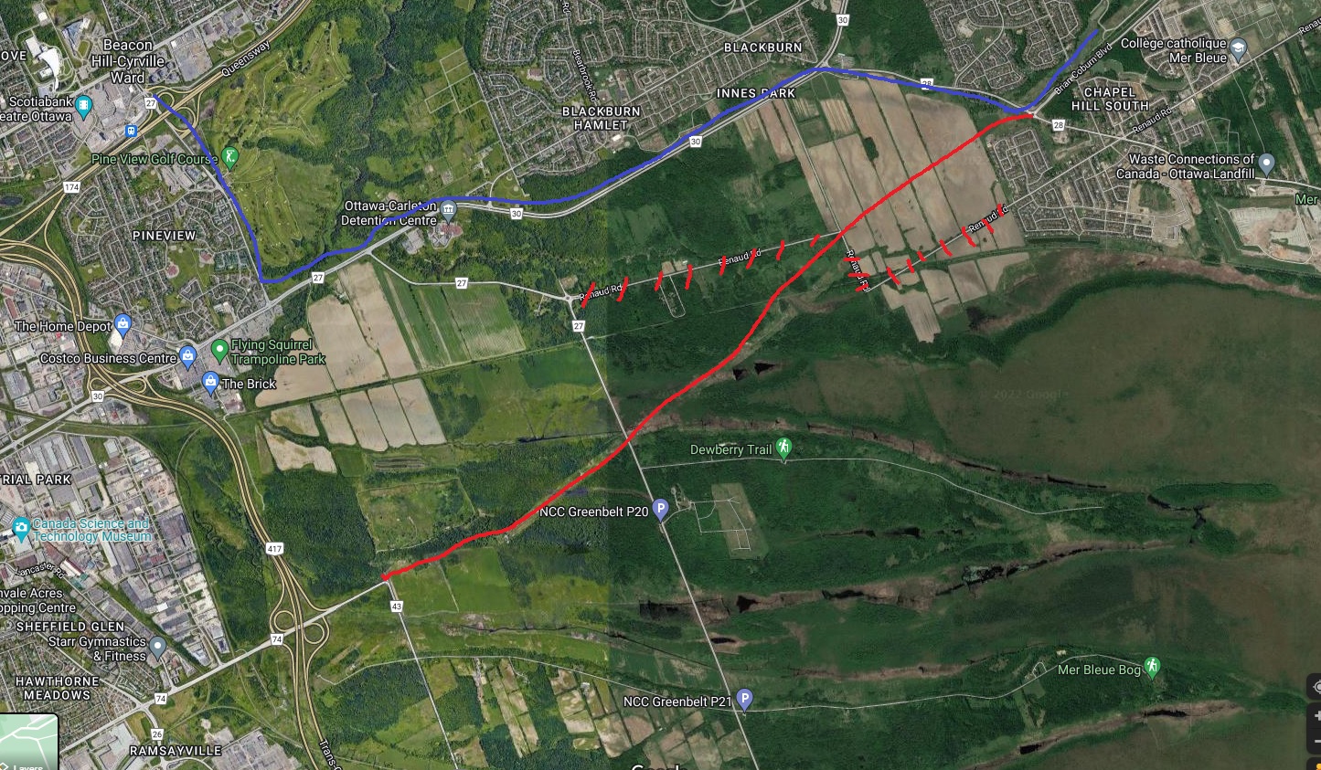
Simple solution would be to Extend Brian Coburn to Walkley following the existing Hydro Line. Sure people will argue that the land is sensitive but I don't think the area in question is that significant. Heck, there's a dump abutting the Mer Bleue conservation area already.
The BRT should be built along Innes Bypass

You could also remove some of the old roadways

https://imgbb.com/J3ry7fQ


Edit: For some reason I can't seem to be able to embed the image into the post?
Reply With Quote
     
     
  #203  
Old Posted Mar 25, 2022, 1:11 PM
J.OT13's Avatar
J.OT13 J.OT13 is offline
Moderator
 
Join Date: Mar 2012
Location: Ottawa
Posts: 29,044
Quote:
Originally Posted by Harley613 View Post
On this map the Brian Coburn extension meets the Hunt Club section before it meets Innes, allowing you to choose whichever one makes more sense once you get there and avoiding touching Innes if you don't have to. It doesn't make them one, but I think it makes sense.
It's the short distance between traffic lights that scares me. I can imagine major back-ups and having to waiting multiple light-cycles before getting through.

In general, I just don't see the Hunt Club extension as being useful in any way. Use that money for Baseline, Kanata-North or Cumberland BRT.

Quote:
Originally Posted by Tesladom View Post
I don't get the whole parkway, Option 7 is not really logical to me neither

Simple solution would be to Extend Brian Coburn to Walkley following the existing Hydro Line. Sure people will argue that the land is sensitive but I don't think the area in question is that significant. Heck, there's a dump abutting the Mer Bleue conservation area already.
The BRT should be built along Innes Bypass

You could also remove some of the old roadways

https://imgbb.com/J3ry7fQ


Edit: For some reason I can't seem to be able to embed the image into the post?
Now that's WAY to close to the Mer Bleu bog. It would need to curve up, using the upper part of Renaud. We could then still eliminate lower Renaud.

Reply With Quote
     
     
  #204  
Old Posted Mar 25, 2022, 1:36 PM
Tesladom Tesladom is offline
Registered User
 
Join Date: May 2019
Posts: 584
Quote:
Originally Posted by J.OT13 View Post
Now that's WAY to close to the Mer Bleu bog. It would need to curve up, using the upper part of Renaud. We could then still eliminate lower Renaud.
And what? the Dump on the upper right side isn't?

There are already roads that traverse the Bog already, this way you could build a proper roadway around the sensitive areas and eliminate the other roadways. I simply drew the line as a reference, it could curve around a bit
This would be much better than Option 7 and this silly Parkway idea (and likely cheaper and more effective)

Reply With Quote
     
     
  #205  
Old Posted Mar 25, 2022, 1:49 PM
Harley613's Avatar
Harley613 Harley613 is offline
Registered User
 
Join Date: Jun 2009
Location: Aylmer, QC
Posts: 6,896
Quote:
Originally Posted by Tesladom View Post
And what? the Dump on the upper right side isn't?

There are already roads that traverse the Bog already, this way you could build a proper roadway around the sensitive areas and eliminate the other roadways. I simply drew the line as a reference, it could curve around a bit
This would be much better than Option 7 and this silly Parkway idea (and likely cheaper and more effective)

I like this....
__________________
Instagram: https://www.instagram.com/the.harleydavis/
Reply With Quote
     
     
  #206  
Old Posted Mar 25, 2022, 2:00 PM
J.OT13's Avatar
J.OT13 J.OT13 is offline
Moderator
 
Join Date: Mar 2012
Location: Ottawa
Posts: 29,044
Quote:
Originally Posted by Tesladom View Post
And what? the Dump on the upper right side isn't?
Two wrongs don't make a right.

Quote:
[There are already roads that traverse the Bog already, this way you could build a proper roadway around the sensitive areas and eliminate the other roadways. I simply drew the line as a reference, it could curve around a bit
This would be much better than Option 7 and this silly Parkway idea (and likely cheaper and more effective)

Liking this better.
Reply With Quote
     
     
  #207  
Old Posted Mar 25, 2022, 2:01 PM
hwy418 hwy418 is offline
Registered User
 
Join Date: Jun 2013
Posts: 410
Quote:
Originally Posted by Tesladom View Post
And what? the Dump on the upper right side isn't?

There are already roads that traverse the Bog already, this way you could build a proper roadway around the sensitive areas and eliminate the other roadways. I simply drew the line as a reference, it could curve around a bit
This would be much better than Option 7 and this silly Parkway idea (and likely cheaper and more effective)

This is exactly what should be built! BRT should go from Chapel Hill PR, north on Navan Rd, then west on BHBP to Innes and Blair Rd. Orleans NEEDS a third way to cross the Greenbelt to provide a little redundancy in the road network.
Reply With Quote
     
     
  #208  
Old Posted Mar 25, 2022, 3:31 PM
Kelnoz Kelnoz is offline
Registered User
 
Join Date: Dec 2020
Posts: 175
Quote:
Originally Posted by hwy418 View Post
This is exactly what should be built! BRT should go from Chapel Hill PR, north on Navan Rd, then west on BHBP to Innes and Blair Rd. Orleans NEEDS a third way to cross the Greenbelt to provide a little redundancy in the road network.
Did everyone just forget St-Joseph exists? If you think 3 is the magic number of crossings then we're already good
Reply With Quote
     
     
  #209  
Old Posted Mar 25, 2022, 3:46 PM
orleans_man orleans_man is offline
Registered User
 
Join Date: Dec 2009
Posts: 65
Quote:
Originally Posted by Kelnoz View Post
Did everyone just forget St-Joseph exists? If you think 3 is the magic number of crossings then we're already good
Two things:
1) We are really talking about the needs of South-Orleans with this one and they have only one decent option currently (Innes).
2) Yes it does exit Orleans, and much of Orleans use it to get to get onto the 174 to go East into Ottawa. So Maybe there's currently 2.5 ways out of Orleans
Reply With Quote
     
     
  #210  
Old Posted Mar 25, 2022, 4:52 PM
rocketphish's Avatar
rocketphish rocketphish is offline
Planet Ottawa and beyond
 
Join Date: Feb 2009
Location: Greater Ottawa
Posts: 14,660
Nope, this would never fly either... can't disturb the old Ridge Road Landfill site.

Reply With Quote
     
     
  #211  
Old Posted Mar 25, 2022, 5:03 PM
lrt's friend lrt's friend is offline
Registered User
 
Join Date: Dec 2006
Posts: 12,805
I guess I am totally out of sync with current thinking. Transit should only take you downtown. Major boulevards and expressways should be the only access to any other location.

I have argued since I joined this board in 2006 that our transit model is out of whack with reality, that our city is becoming more and more decentralized. As long as we think our transit system should mainly focus on downtown, we are going to lose ridership and the current work from home movement that the pandemic has encouraged has sped up this trend, and any hybrid work arrangement will not bring us back to previous ridership levels.

As long as we keep building major suburban roads with little consideration of improved cross-town transit links, we are further defeating our transit system.

I look at the various proposals for South Orleans and wonder how any of them do anything other than make our city even more car dependent. These proposals pay lip service to transit, since the route does not address where the most people may want to go . The latest proposal now completely bypasses Blackburn Hamlet and most of the Innes corridor.

At the same time, we want to violate sensitive Greenbelt and Mer Bleue land and we know, that transit on these routes will be insignificant or non-existent. Can you imagine a bus on a Bruce Coburn-Renaud-Walkley route? We can't even run a bus down Prince of Wales anymore because the Experimental Farm is a dead zone. This is a far wider dead zone.

We have not even considered the possibility of using the former CPR corridor for a Trillium Line type service that might connect with Bruce Coburn corridor and into the VIA station. That would be too complicated to work with VIA and would not allow us to build 6 more lanes for car traffic. After all, aren't we planning for 90%+ modal share for automobiles?

Ottawa has become bankrupt in its thinking of how to move people out of cars. The city has given up on it, now that the Confederation Line looks more and more like a big loser now that downtown is no longer the big destination (as I have predicted all along) that it used to be.
Reply With Quote
     
     
  #212  
Old Posted Mar 25, 2022, 5:30 PM
JHikka's Avatar
JHikka JHikka is offline
ハルウララ
 
Join Date: Jul 2009
Location: Toronto
Posts: 12,853
Quote:
Originally Posted by lrt's friend View Post
I guess I am totally out of sync with current thinking. Transit should only take you downtown. Major boulevards and expressways should be the only access to any other location.
Will remember this the next time I take the Sheppard subway or St. Clair streetcar. Perhaps too the Eglinton Line when it opens.
Reply With Quote
     
     
  #213  
Old Posted Mar 25, 2022, 6:02 PM
lrt's friend lrt's friend is offline
Registered User
 
Join Date: Dec 2006
Posts: 12,805
Quote:
Originally Posted by JHikka View Post
Will remember this the next time I take the Sheppard subway or St. Clair streetcar. Perhaps too the Eglinton Line when it opens.
What you are saying is making my point, which perhaps I could have worded a little better. Those are all creating cross-town connections in Toronto that don't go directly downtown. Don't forget the Finch LRT that is also now under construction. They reflect that not everybody is heading to downtown Toronto.

We can't even get the Baseline project off the ground, originally to be built in 2020-2021 now delayed to 2031++.

Last edited by lrt's friend; Mar 25, 2022 at 7:17 PM.
Reply With Quote
     
     
  #214  
Old Posted Mar 25, 2022, 7:32 PM
phil235's Avatar
phil235 phil235 is online now
Registered User
 
Join Date: Sep 2006
Location: Ottawa
Posts: 4,602
Quote:
Originally Posted by lrt's friend View Post
I have argued since I joined this board in 2006 that our transit model is out of whack with reality, that our city is becoming more and more decentralized. As long as we think our transit system should mainly focus on downtown, we are going to lose ridership and the current work from home movement that the pandemic has encouraged has sped up this trend, and any hybrid work arrangement will not bring us back to previous ridership levels.
I would phrase this a little differently. It's not that our transit system is focused on downtown. If anything, we have largely ignored the need to service our densest, most transit-friendly downtown neighbourhoods with decent transit, and ridership has suffered.

I think what you mean is that our transit system is focused on bringing commuters downtown from distant suburbs. Our train lines are more akin to commuter lines than actual urban transit. What we need is transit that allows people to move around the city for reasons other than the the commute. To me that means abandoning the idea of reaching every cul-de-sac and crescent with a bus every 45 minutes, and committing to frequent and reliable transit along high volume corridors.
Reply With Quote
     
     
  #215  
Old Posted Mar 25, 2022, 8:10 PM
lrt's friend lrt's friend is offline
Registered User
 
Join Date: Dec 2006
Posts: 12,805
Quote:
Originally Posted by phil235 View Post
I would phrase this a little differently. It's not that our transit system is focused on downtown. If anything, we have largely ignored the need to service our densest, most transit-friendly downtown neighbourhoods with decent transit, and ridership has suffered.

I think what you mean is that our transit system is focused on bringing commuters downtown from distant suburbs. Our train lines are more akin to commuter lines than actual urban transit. What we need is transit that allows people to move around the city for reasons other than the the commute. To me that means abandoning the idea of reaching every cul-de-sac and crescent with a bus every 45 minutes, and committing to frequent and reliable transit along high volume corridors.
We have already abandoned the idea of one seat rides for suburban transit riders.

I don't think it is wise to abandon the suburbs either, but a bus every half hour is enough in most suburban locations. This is where the bulk of the population growth is, and therefore potential new ridership, if it is handled properly.

Yes, for the most part I agree with everything else that you have said. We need to look at a map and line out where it makes sense to have better service, and deliver a core of frequent routes that make a transit grid that I have mentioned in the past. That transit grid should make it easier to get to most major transit destinations in the city without necessarily going through downtown. Pushing most people through downtown is a mistake.

Some other cities have had success in creating a core of frequent routes and generating significant new ridership, so the extra cost can be offset by new revenue.

What Ottawa has done over the last 10 years or so, by reducing frequency has had the opposite effect. It makes transit unattractive and starts a ridership downward spiral as we have seen. You cannot cut frequency over and over again without making transit uncompetitive.
Reply With Quote
     
     
  #216  
Old Posted Mar 28, 2022, 11:48 AM
rocketphish's Avatar
rocketphish rocketphish is offline
Planet Ottawa and beyond
 
Join Date: Feb 2009
Location: Greater Ottawa
Posts: 14,660
City hopes dealmaking strategy for LRT can convince NCC to unlock greenbelt for east-end road
The city's sought-after 100 days of diplomacy harkens back to a negotiation between the city and NCC over the city-desired route for the western LRT extension.

Jon Willing, Ottawa Citizen
Publishing date: Mar 28, 2022 • 1 hour ago • 6 minute read


After a 100-day negotiation secured federal land for the LRT expansion in Ottawa’s west end seven years ago, city council thinks the same strategy could unlock greenbelt land for a $306-million roadway and transit project in the east.

The National Capital Commission will need to agree to it, but so far there’s no indication the agency wants to give up more than 40 acres of open space for a new municipal road and Transitway stretching west from south Orléans.

With council now appealing directly to the federal minister in charge of the NCC, the city is trying to convince the agency that its preferred design to extend Brian Coburn Boulevard and a bus-only road west is the only acceptable way to build the project.

It’s yet another battle between the city and NCC over land in Canada’s capital.

The city needs to relieve traffic congestion for motorists travelling to and from growing Orléans communities and has planned to extend Brian Coburn Boulevard, and to build bus-only lanes, across the NCC greenbelt.

The official plan calls for development expansion in south Orléans to accommodate citywide growth projections. Those new residents will join thousands of other motorists and public transit users trying to access central and west Ottawa.


The NCC supports options that are closer to Navan Road and the Blackburn Hamlet Bypass, in line with the city’s original intentions for the project before detailed geotechnical studies exposed difficult ground conditions.

The NCC doesn’t want the project fragmenting farmland and natural areas in the greenbelt and running near the Mer Bleue bog.

But the city’s top-ranked, “technically preferred” design does exactly that, extending Brian Coburn Boulevard and the Transitway west to an expanded Renaud Road and Anderson Road and heading north toward Innes Road. Buses could access Blair Road en route to Blair LRT station. The proposed design includes a new multi-use pathway along the road. The road would run north of the bog, not through it.

The design is preferred, in large part, because it’s the least expensive option. According to a 2021 estimate, the road portion would cost $128 million and the Transitway portion would cost $178 million. The city would need to find the money for the work, but first it needs to have the design confirmed.

In the city’s preferred design, the NCC would need to make available 42 hectares of greenbelt land.

If the city went with an option the NCC prefers, the project would cost another $174 million. The city has argued that its own preferred option is broadly more ecologically sensitive than the NCC’s preference, according to a study that took 31 criteria into account.

The city’s sought-after 100 days of diplomacy harkens back to a negotiation between the city and NCC over the city-desired route for the western LRT extension through Sir John A. Macdonald Parkway lands. They inked the deal in 2015 and an LRT tunnel is under construction there today.

The NCC’s board is expected to receive an update on the Brian Coburn Boulevard dispute during a meeting in April.

NCC spokesperson Valérie Dufour said the agency worked with the city in 2013 on an agreed route “that better protects species at risk, as well as core natural areas and farmland in the greenbelt, including the internationally recognized Mer Bleu wetland.”

The NCC would still work with the city on a design based on two options running closer to Navan Road and the Blackburn Hamlet Bypass, even though those options are different from what the agency and city originally agreed to, Dufour said.

In a letter to city management in September 2020 underscoring the NCC’s position, CEO Tobi Nussbuam said, “there is great risk of public confusion … as to why an alignment option is being advanced by the city with the clear and unambiguous opposition of the affected land owner.”

Lucie Bureau, the NCC’s director of long-range planning and transportation, followed up with a December 2021 letter questioning the city’s proposal to provide “contaminated” land used for roads and a forest in Chapel Hill in exchange for ecological or agricultural lands in the greenbelt.

Council muddied the matter in February 2022 by roping in an unrelated NCC file on the other side of the city. The NCC wants to build new embassies on green space in Mechanicsville and council said no, with some councillors bringing up NCC opposition to the city’s plan for Brian Coburn Boulevard. The NCC has appealed that decision to the Ontario Land Tribunal.

Meanwhile, Orléans residents feel left out of city road projects. Several east-end community associations have backed the city’s plan to build the new road and Transitway.

Heather Buchanan, who’s on the planning committee of the Bradley Estates Community Association, said better road infrastructure in the area had been discussed by municipal government for about 30 years.

Over that time, south Orléans has significantly grown, with new developments regularly popping up and exacerbating a long-standing traffic problem.

“City approves the developments, they have to provide the infrastructure,” Buchanan said.

However, the city’s plan has been predictably met with opposition from people concerned about the environmental impact of building new roads in the eastern greenbelt. The local chapter of the Canadian Parks and Wilderness Society has voiced strong opposition.

The chapter’s executive director, John McDonnell, told councillors earlier this month that members sent 1,300 emails to the mayor and councillors, sounding the alarm over climate change and the loss of biodiversity and agricultural land.

“Simply put, greenbelt ecosystems are fragile and cannot support further fragmentation,” McDonnell told the transportation committee earlier this month, noting the sensitive biodiversity in the Mer Bleue sector. He accused the city of treating the greenbelt as a “bank of land to be developed rather than the ecological, educational and recreational gem it is.”

There’s also skepticism on city council about road expansions when precious infrastructure money could be used for sustainable transportation projects. Capital ward Coun. Shawn Menard has spent the term trying to convince colleagues they shouldn’t spend money on new roads since they’ll just get clogged with more cars.

On the other hand, east-end councillors see the Brian Coburn Boulevard project as a critical addition for a suburban community that has few main corridors to move heavy traffic and high-capacity bus routes. They see the transportation problem as a threat to Orléans’s economic development.

The project has been one of the largest advocacy files for Innes ward Coun. Laura Dudas and Cumberland ward Coun. Catherine Kitts as representatives of south Orléans residents.

“One of the more pressing issues facing the south end of Orléans is that development has outpaced infrastructure and development in the south end of Orléans has been absolutely explosive in the last 15 years,” Kitts said during last Wednesday’s council meeting.

It was Kitts who won support for the idea of a 100-day negotiation period with the NCC. During the council meeting, she thanked planning general manager Stephen Willis for helping her craft the motion.

That connection could be key. Willis was executive director of the NCC’s capital planning branch during the 100-day LRT negotiation in 2015.

However, when it comes to the east-end road dispute, the circumstances are notably different.

The LRT dispute had an Ottawa MP, John Baird, as the federal cabinet minister in charge of the NCC, with the future LRT system passing through his riding. Today, the cabinet minister overseeing the NCC is Hamilton-area MP Filomena Tassi; the governing Liberals have decided not to assign a local minister to the NCC oversight role.

Also, the Brian Coburn Boulevard extension, while it comes with a Transitway component that will one day carry battery-electric buses, would build a new road and expand other roads for cars across the NCC’s prized greenbelt. The LRT dispute was about building electrified mass public transit.

Time is ticking down if the city wants to avoid further delays.

The council term will end in November and there will be new political leadership at city hall. Transportation priorities, while proposed by city planners after careful study, could change with new political direction.

On Wednesday, Mayor Jim Watson, who’s not seeking re-election in the October municipal election, voted with the majority in favour of the city-preferred functional design of the Brian Coburn Boulevard and Transitway project. Of eight councillors who voted against it, two are publicly declared mayoral candidates: Diane Deans and Catherine McKenney.

[email protected]
twitter.com/JonathanWilling


https://ottawacitizen.com/news/local-new...cc-to-unlock-greenbelt-for-east-end-road

Reply With Quote
     
     
  #217  
Old Posted Apr 1, 2022, 7:39 PM
Kitchissippi's Avatar
Kitchissippi Kitchissippi is online now
Busy Beaver
 
Join Date: Nov 2005
Location: Ottawa
Posts: 4,691
I'd like to see an option where there would be just a Pineview Bypass with a new 417 interchange, and Innes and the Blackburn Bypass gets widened along with Navan Road to Brian Coburn. Innes through Pineview would be narrowed back to 4 lanes with wider sidewalks and bike tracks plus full MUP on the north side all the way to Blackburn Hamlet. This would largely streamline traffic away from the busy commercial area, while using a lot less of the Greenbelt.


For transit, I'd scrap the Transitway plan and go with an O-Train spur (Line 3 split) after Blair, either going elevated along Innes or picking up the intended Transitway ROW.

Reply With Quote
     
     
  #218  
Old Posted Apr 1, 2022, 7:58 PM
Harley613's Avatar
Harley613 Harley613 is offline
Registered User
 
Join Date: Jun 2009
Location: Aylmer, QC
Posts: 6,896
Oof, I'm not digging your transit idea. That's some pretty gnarly, uneven and sensitive ravine land over Green's creek, you'd be cutting an athletics centre in half, and the area Northwest of Blackburn Hamlet is mostly heavily forested federal RCMP land. This is a very destructive and complicated path. I see where you're coming from when I zoom out but at ground level I can't see this one every happening.
__________________
Instagram: https://www.instagram.com/the.harleydavis/
Reply With Quote
     
     
  #219  
Old Posted Apr 1, 2022, 8:13 PM
Kitchissippi's Avatar
Kitchissippi Kitchissippi is online now
Busy Beaver
 
Join Date: Nov 2005
Location: Ottawa
Posts: 4,691
There's already an old train trestle that ran through there, so it's not like it's impossible terrain. It could be cut-and-cover through the Hornets Nest restoring whatever soccer field might be disturbed. The accessibility a transit station would provide here might even result in additional investment in sports infrastructure especially when that quarry is finally depleted and calls for reuse.
Reply With Quote
     
     
  #220  
Old Posted Apr 5, 2022, 5:50 PM
Tesladom Tesladom is offline
Registered User
 
Join Date: May 2019
Posts: 584
You can't have another interchange added south of Innes road, I think new regulations recommend 2km between each interchange (or something like that), plus your proposed interchange is over the rail line and on a corner
Reply With Quote
     
     
End
 
 
Reply

Go Back   SkyscraperPage Forum > Regional Sections > Canada > Ontario > Ottawa-Gatineau > Transportation
Forum Jump


Forum Jump


All times are GMT. The time now is 11:17 PM.


Powered by vBulletin® Version 3.8.7
Copyright ©2000 - 2026, vBulletin Solutions, Inc.