HomeDiagramsDatabaseMapsForum About
     

Go Back   SkyscraperPage Forum > Regional Sections > Canada > Alberta & British Columbia > Vancouver > Transportation & Infrastructure


Reply

 
Thread Tools Display Modes
     
     
  #981  
Old Posted Nov 5, 2021, 1:38 AM
Migrant_Coconut's Avatar
Migrant_Coconut Migrant_Coconut is offline
Registered User
 
Join Date: Oct 2015
Location: Kitsilano/Fairview
Posts: 10,178
Eh, it frees up the road for people who need to drive instead of want to (and definitely on the feeder roads that lead into Broadway). It's not like traffic can get back to normal - not after the City turns the parking lanes into sidewalks.
Reply With Quote
     
     
  #982  
Old Posted Nov 5, 2021, 5:47 AM
fredinno's Avatar
fredinno fredinno is offline
Registered User
 
Join Date: Jan 2012
Posts: 2,317
Quote:
Originally Posted by Migrant_Coconut View Post
Eh, it frees up the road for people who need to drive instead of want to (and definitely on the feeder roads that lead into Broadway). It's not like traffic can get back to normal - not after the City turns the parking lanes into sidewalks.
I never understood that- especially on Broadway. I would imagine it will eventually be undone for practical reasons (other than being unnecessary- it makes sense on the narrow Davie St. sidewalks, not on Broadway!)
Reply With Quote
     
     
  #983  
Old Posted Nov 5, 2021, 10:29 PM
officedweller officedweller is offline
Registered User
 
Join Date: Jul 2001
Location: Vancouver
Posts: 41,782
Quote:
Originally Posted by fredinno View Post
I never understood that- especially on Broadway. I would imagine it will eventually be undone for practical reasons (other than being unnecessary- it makes sense on the narrow Davie St. sidewalks, not on Broadway!)
I don't think a lot pof people use Broadway now for driving across the city because of the number of traffic lights. People will just change their habits to 12th or 16th (West 6th looks like it'll get a lot more lights in future).

As for parking for destinations along the route, people will just change where they shop and dine to whatever location suits their mode of transport. The subway will bring in lots of replacement customers.
Reply With Quote
     
     
  #984  
Old Posted Nov 5, 2021, 10:38 PM
WarrenC12's Avatar
WarrenC12 WarrenC12 is offline
Registered User
 
Join Date: May 2007
Location: East OV!
Posts: 24,711
Quote:
Originally Posted by officedweller View Post
I don't think a lot pof people use Broadway now for driving across the city because of the number of traffic lights. People will just change their habits to 12th or 16th (West 6th looks like it'll get a lot more lights in future).

As for parking for destinations along the route, people will just change where they shop and dine to whatever location suits their mode of transport. The subway will bring in lots of replacement customers.
Broadway has been a bad choice for decades. 12th has always been better. The Skytrain will be a massive increase in capacity for the area.
Reply With Quote
     
     
  #985  
Old Posted Nov 5, 2021, 10:57 PM
Migrant_Coconut's Avatar
Migrant_Coconut Migrant_Coconut is offline
Registered User
 
Join Date: Oct 2015
Location: Kitsilano/Fairview
Posts: 10,178
Worth noting the parking lanes are used for (ahem) parking most of the day. And since the M-Line can absorb pretty much all voluntary driving, the right incentives should keep the road free for freight and necessary driving. It's not like there'll be a massive increase in semis or ambulances going to Point Grey/UBC.
Reply With Quote
     
     
  #986  
Old Posted Nov 7, 2021, 3:48 PM
Jimbo604 Jimbo604 is offline
Registered User
 
Join Date: Jan 2012
Posts: 1,888
Quote:
Originally Posted by madog222 View Post
New photos from BC MOTI's Flickr

https://www.flickr.com/photos/tranbc/
Super transit nerd Sunday morning thought: Curious about the location/length of transition from elevated to tunnel. Obviously between Emily Carr station and old-MEC office building but is there anything more specific?
Reply With Quote
     
     
  #987  
Old Posted Nov 7, 2021, 4:40 PM
madog222 madog222 is online now
Moderator
 
Join Date: Jan 2014
Posts: 4,211
Quote:
Originally Posted by Jimbo604 View Post
Super transit nerd Sunday morning thought: Curious about the location/length of transition from elevated to tunnel. Obviously between Emily Carr station and old-MEC office building but is there anything more specific?
This shows the transition down to grade starting between Fraser and Carolina so most of the transition should be West of Carolina behind Emily Carr.

• Video Link
Reply With Quote
     
     
  #988  
Old Posted Nov 8, 2021, 5:04 AM
fredinno's Avatar
fredinno fredinno is offline
Registered User
 
Join Date: Jan 2012
Posts: 2,317
Quote:
Originally Posted by Migrant_Coconut View Post
Worth noting the parking lanes are used for (ahem) parking most of the day. And since the M-Line can absorb pretty much all voluntary driving, the right incentives should keep the road free for freight and necessary driving. It's not like there'll be a massive increase in semis or ambulances going to Point Grey/UBC.
There's such a thing as a making a sidewalk too big- it makes everything feel way more empty than it should be. And other buses use Broadway as well as the 99.
Reply With Quote
     
     
  #989  
Old Posted Nov 8, 2021, 6:34 AM
Migrant_Coconut's Avatar
Migrant_Coconut Migrant_Coconut is offline
Registered User
 
Join Date: Oct 2015
Location: Kitsilano/Fairview
Posts: 10,178
Quote:
Originally Posted by fredinno View Post
There's such a thing as a making a sidewalk too big- it makes everything feel way more empty than it should be. And other buses use Broadway as well as the 99.
It's an extra three-ish metres on top of the existing five - hardly Orchard Road. 'Sides, given the foot traffic that usually results from SkyTrain stations, retail villages and crazy amounts of density (let alone all three), I'd be more worried about the opposite.

The 9/14/etc can spend a lot of time weaving in and out of parked cars, so removing those lanes is probably more of a loss for vehicle drivers than buses.

Reply With Quote
     
     
  #990  
Old Posted Nov 8, 2021, 6:53 AM
jollyburger jollyburger is online now
Registered User
 
Join Date: Dec 2015
Posts: 15,791
Reply With Quote
     
     
  #991  
Old Posted Nov 8, 2021, 5:07 PM
WarrenC12's Avatar
WarrenC12 WarrenC12 is offline
Registered User
 
Join Date: May 2007
Location: East OV!
Posts: 24,711
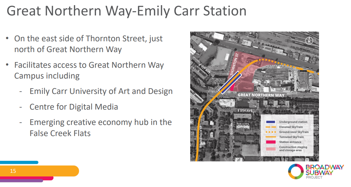
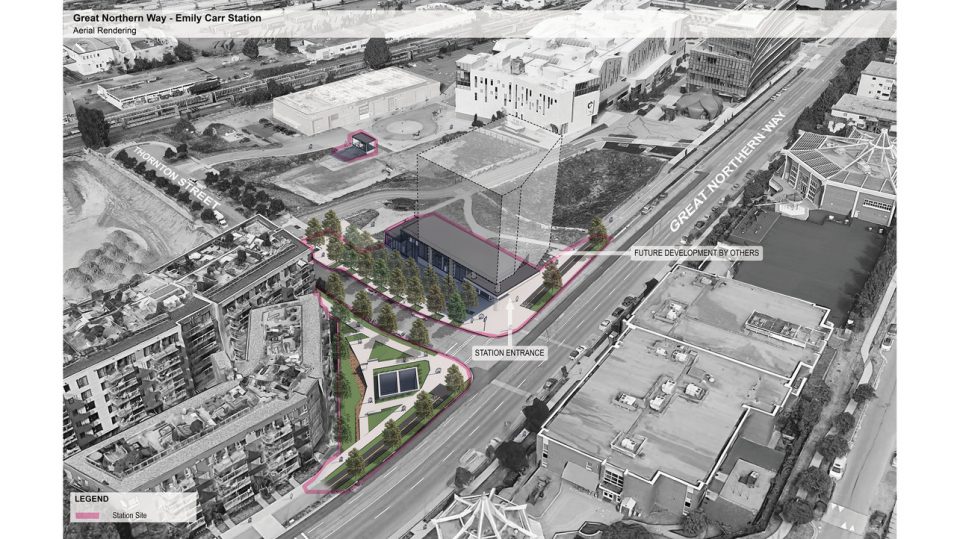
No entrance from East 1st kind of 🞵🞵🞵🞵🞵 on that station, I guess we'll see how it looks when completed.
Reply With Quote
     
     
  #992  
Old Posted Nov 8, 2021, 5:33 PM
Tvisforme's Avatar
Tvisforme Tvisforme is online now
Registered User
 
Join Date: Sep 2014
Location: Metro Vancouver
Posts: 2,177
Quote:
Originally Posted by WarrenC12 View Post
No entrance from East 1st kind of 🞵🞵🞵🞵🞵 on that station, I guess we'll see how it looks when completed.
I don't think it will be an issue; the station is underground, so one would just walk a block down Thornton Street to the corner with Great Northern Way, which is where the existing stop for the #84 is located.
Reply With Quote
     
     
  #993  
Old Posted Nov 8, 2021, 6:14 PM
jollyburger jollyburger is online now
Registered User
 
Join Date: Dec 2015
Posts: 15,791
Why would you even want a second entrance on 1st?


https://www.urbanyvr.com/broadway-subway-extension-station-renderings/
Reply With Quote
     
     
  #994  
Old Posted Nov 8, 2021, 7:13 PM
scottN scottN is offline
Registered User
 
Join Date: Mar 2019
Posts: 286
Quote:
Originally Posted by jollyburger View Post
Why would you even want a second entrance on 1st?
It orients the station to the Central Valley Greenway and the Emily Carr pedestrian corridor rather than the highway-like great northern way.
Reply With Quote
     
     
  #995  
Old Posted Nov 8, 2021, 7:26 PM
Migrant_Coconut's Avatar
Migrant_Coconut Migrant_Coconut is offline
Registered User
 
Join Date: Oct 2015
Location: Kitsilano/Fairview
Posts: 10,178
Quote:
Originally Posted by scottN View Post
It orients the station to the Central Valley Greenway and the Emily Carr pedestrian corridor rather than the highway-like great northern way.
Which means the 84 stop is right in front of the entrance - transit should facilitate transit. Doesn't help that there's maybe five people/minute on the Greenway.
Reply With Quote
     
     
  #996  
Old Posted Nov 8, 2021, 7:28 PM
WarrenC12's Avatar
WarrenC12 WarrenC12 is offline
Registered User
 
Join Date: May 2007
Location: East OV!
Posts: 24,711
Quote:
Originally Posted by scottN View Post
It orients the station to the Central Valley Greenway and the Emily Carr pedestrian corridor rather than the highway-like great northern way.
Yeah foot traffic will be coming and going from the opposite side of the entrance. East 1st will develop along that stretch significantly in the medium term.
Reply With Quote
     
     
  #997  
Old Posted Nov 8, 2021, 7:29 PM
WarrenC12's Avatar
WarrenC12 WarrenC12 is offline
Registered User
 
Join Date: May 2007
Location: East OV!
Posts: 24,711
Quote:
Originally Posted by Migrant_Coconut View Post
Which means the 84 stop is right in front of the entrance - transit should facilitate transit. Doesn't help that there's maybe five people/minute on the Greenway.
Who's transferring at that station to/from the 84? Will the 84 even exist in it's current form when this line opens? I doubt it.
Reply With Quote
     
     
  #998  
Old Posted Nov 8, 2021, 7:38 PM
jollyburger jollyburger is online now
Registered User
 
Join Date: Dec 2015
Posts: 15,791
Quote:
Originally Posted by WarrenC12 View Post
Who's transferring at that station to/from the 84? Will the 84 even exist in it's current form when this line opens? I doubt it.
There's going to be something that serves Olympic Village and it seems logical to turn it around at VCC.
Reply With Quote
     
     
  #999  
Old Posted Nov 8, 2021, 7:50 PM
jollyburger jollyburger is online now
Registered User
 
Join Date: Dec 2015
Posts: 15,791
Quote:
Originally Posted by WarrenC12 View Post
Yeah foot traffic will be coming and going from the opposite side of the entrance. East 1st will develop along that stretch significantly in the medium term.
RIP people who can't walk 2 minutes in the opposite direction.
Reply With Quote
     
     
  #1000  
Old Posted Nov 8, 2021, 7:53 PM
Migrant_Coconut's Avatar
Migrant_Coconut Migrant_Coconut is offline
Registered User
 
Join Date: Oct 2015
Location: Kitsilano/Fairview
Posts: 10,178
Yeah, the 84 is the only service for 2nd between Cambie and Clark - it's not going anywhere.

Quote:
Originally Posted by WarrenC12 View Post
Yeah foot traffic will be coming and going from the opposite side of the entrance. East 1st will develop along that stretch significantly in the medium term.
I'm seeing three, maybe four future developments that would outright benefit from an entrance on 1st. The rest most likely won't mind walking on 2nd instead.
Reply With Quote
     
     
This discussion thread continues

Use the page links to the lower-right to go to the next page for additional posts
 
 
Reply

Go Back   SkyscraperPage Forum > Regional Sections > Canada > Alberta & British Columbia > Vancouver > Transportation & Infrastructure
Forum Jump


Forum Jump


All times are GMT. The time now is 9:49 PM.


Powered by vBulletin® Version 3.8.7
Copyright ©2000 - 2026, vBulletin Solutions, Inc.