HomeDiagramsDatabaseMapsForum About
     

Go Back   SkyscraperPage Forum > Regional Sections > Canada > Alberta & British Columbia > Vancouver > Transportation & Infrastructure


Reply

 
Thread Tools Display Modes
     
     
  #1401  
Old Posted Dec 24, 2015, 1:46 AM
aberdeen5698's Avatar
aberdeen5698 aberdeen5698 is offline
Registered User
 
Join Date: May 2010
Posts: 4,776
Quote:
Originally Posted by Stingray2004 View Post
Haha. Ya do realize that the Tyee is not a credible source?
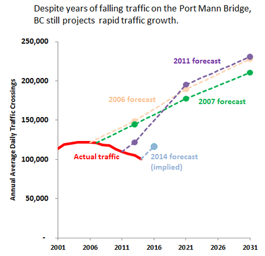
Are you disputing the numbers? They paint a poor picture regardless of the source. Yes, the numbers are finally up for the last 6 months but I think it's a bit early to be breaking out the champagne yet, especially given that even these newer numbers are still about 22% below the volumes predicted back in 2011 [source].

As a taxpayer who's on the hook for the traffic shortfall I hope that recent trends continue. But in the face of a decade of missed predictions I'll wait and see. And keep my fingers crossed that the same mismanaged expectations that have become a worrying pattern with our recent highway projects don't plague the tunnel replacement project.
Reply With Quote
     
     
  #1402  
Old Posted Dec 24, 2015, 2:20 AM
Metro-One's Avatar
Metro-One Metro-One is online now
Registered User
 
Join Date: Sep 2008
Location: Japan
Posts: 17,907
Quote:
Originally Posted by WarrenC12 View Post
PMB Volumes are a bit of a joke. 2015-16 should provide the high end of any forecasts, as we have good economic growth and really cheap gas.

I would not call 100 000 vehicles a day a joke. That is a pretty heavily used corridor.

The forecasts seem pretty out of tune though, hence I never trust any long term forecasts (traffic growth, population growth, hell, even weather).

I also wonder if some of the stall in traffic growth is due to the GEB. it must have siphoned off at least a little of the PMB's traffic.
__________________
Bridging the Gap
Check out my Flickr: https://www.flickr.com/photos/30634635@N03/with/29495547810/ and Youtube channel https://www.youtube.com/channel/UCV0_0h9qKlhxXFxuAey_q6Q
Reply With Quote
     
     
  #1403  
Old Posted Dec 24, 2015, 3:49 AM
Rico Rico is offline
Registered User
 
Join Date: Feb 2012
Posts: 319
Quote:
Originally Posted by Metro-One View Post
I would not call 100 000 vehicles a day a joke. That is a pretty heavily used corridor.

The forecasts seem pretty out of tune though, hence I never trust any long term forecasts (traffic growth, population growth, hell, even weather).

I also wonder if some of the stall in traffic growth is due to the GEB. it must have siphoned off at least a little of the PMB's traffic.
The GEB is also under projections. Are we seeing a trend??? If the GMT meets projections I will eat my dirty underware. The GMT projections will be the most off of the recent bridge projections...short of Christy saying she will scrap the ALR and pave everything tomorrow. I suspect the GEB and Port Mann projections were legitimate attempts at forecasting traffic, I don't think the GMT business case is anything more than someone telling the forecaster I promised a 10 lane bridge, make me a business case that justifies it.
Reply With Quote
     
     
  #1404  
Old Posted Dec 24, 2015, 4:07 AM
Metro-One's Avatar
Metro-One Metro-One is online now
Registered User
 
Join Date: Sep 2008
Location: Japan
Posts: 17,907
Below forecast as it may be, still some of the traffic on the GEB would likely have used the Port man bridge prior to its opening (I know there were many trips that I made to Surrey from Maple Ridge via the Port Mann that were promptly redirected onto the GEB once it opened). In fact, after the GEB opened I almost never used the Port Mann again when I lived in Maple Ridge.

And below projections as it may be, the GEB was a pretty logical link to have seeing how wide the gap between the Port Mann and Mission Bridge was in a built up area.

Also, if you look carefully this project (GMT) has been designed very consciously regarding minimizing the loss of ALR (and actually, seeing how compact the new interchanges are, there may even be no net loss of land).

So anti-road people can't really use the loss of ALR argument on this project.

The huge mall / industrial park development on native land near the ferry terminal is a massive loss of ALR, but PC policies beloved by the anti-highway group will make sure we never call that one out.
__________________
Bridging the Gap
Check out my Flickr: https://www.flickr.com/photos/30634635@N03/with/29495547810/ and Youtube channel https://www.youtube.com/channel/UCV0_0h9qKlhxXFxuAey_q6Q
Reply With Quote
     
     
  #1405  
Old Posted Dec 24, 2015, 4:32 AM
logicbomb logicbomb is offline
Joshua B.
 
Join Date: Sep 2010
Posts: 1,191
Quote:
Originally Posted by Metro-One View Post

Also, if you look carefully this project (GMT) has been designed very consciously regarding minimizing the loss of ALR (and actually, seeing how compact the new interchanges are, there may even be no net loss of land).

So anti-road people can't really use the loss of ALR argument on this project.

The huge mall / industrial park development on native land near the ferry terminal is a massive loss of ALR, but PC policies beloved by the anti-highway group will make sure we never call that one out.
I am not "anti-road" but I question whether or not this project will put pressure on the provincial govt to unlock ALR parcels. This will be a definite must if we are to keep housing costs down, yes I get the argument for keeping farmland intact, but also realize that we are at a crossroads and need to rapidly develop (priority right now is to increase supply of housing). These environmentalists or "anti-road people" according to you have a right to be concerned. A massive new bridge will further entice people to move to Ladner/Delta.
Reply With Quote
     
     
  #1406  
Old Posted Dec 24, 2015, 4:47 AM
Klazu's Avatar
Klazu Klazu is offline
Registered User
 
Join Date: Apr 2012
Location: Above Metro Vancouver clouds
Posts: 10,394
Quote:
Originally Posted by moosejaw View Post
In response to the counter flow lanes on the AFB, a similar system that's in place in Honolulu and San Juan where they use a zipper dual jersey barrier with a modified bus that moves the median to suit traffic flow patterns.
There is also a bridge in Philadelphia (I believe) where such zipper-machine is being used. In Honolulu they also have a long stretch of six-lane road where they manually add cones to make for a counter-flow lane every single day. Road officials drive down the road and keep placing traffic cones every so many meters to make for a 2+4 lane configuration. Interestingly enough, the left turn bays are kept where they are, so one has to cross a lane to get on one.

That must have been the most inconvenient counter-flow implementation I have ever seen.
Reply With Quote
     
     
  #1407  
Old Posted Dec 24, 2015, 4:55 AM
Klazu's Avatar
Klazu Klazu is offline
Registered User
 
Join Date: Apr 2012
Location: Above Metro Vancouver clouds
Posts: 10,394
Quote:
Originally Posted by aberdeen5698 View Post
Actually, traffic was declining for five years before the tolls were implemented (and declines started before the financial crisis), and yet the 2011 forecast still called for a huge increase in traffic volumes which would result in higher traffic levels than the original, discredited 2006 and 2007 forecasts. This is known as "wearing blinkers".

It's not just BC that's making this mistake - it's common among highway engineers all over the Western Hemisphere. Of course it's in the best interests of highway engineers for traffic volumes to rise, but at some point we have to come to the realization that "fool me twice, shame on us".

This is exactly why people are questioning the need for 10 lanes. Unfortunately the GMT replacement will already be built by the time we know for sure whether this is just a blip or if the habits of the younger generation are really creating a lasting turning point with regard to car usage.
Sure, but to be fair, similar "tweaking" of forecasts happens also with transit projects and most other construction projects under the sun. They always have to sell the project and predicting the future is also not easy, when you only have past data to rely on. But I do hear you and what you are saying.

It's also and interesting point about the younger generations perhaps choosing to use cars less. This is true, but a trend that we cannot yet anticipate well are self-driving cars. Maybe traffic will explode when taking a self-driving car is a breeze? Or maybe people will work more remotely.

The fact still is that the region will see 1 million new people in short time and no matter how the average commuting trends change, that will still introduce a lot of new traffic. It is totally unrealistic to think that bridge crossings over Fraser River wouldn't increase if you have a 40% increase in the people, most of which will be living south of the river.
Reply With Quote
     
     
  #1408  
Old Posted Dec 24, 2015, 4:55 AM
Metro-One's Avatar
Metro-One Metro-One is online now
Registered User
 
Join Date: Sep 2008
Location: Japan
Posts: 17,907
Quote:
Originally Posted by logicbomb View Post
I am not "anti-road" but I question whether or not this project will put pressure on the provincial govt to unlock ALR parcels. This will be a definite must if we are to keep housing costs down, yes I get the argument for keeping farmland intact, but also realize that we are at a crossroads and need to rapidly develop (priority right now is to increase supply of housing). These environmentalists or "anti-road people" according to you have a right to be concerned. A massive new bridge will further entice people to move to Ladner/Delta.
I honestly ca't figure out if you are pro-considering removing ALR or against it...

I really dont think there is any need to consider removing ALR and improving this highway should not add any pressure to do so.

Instead, this highway will improve connections between destinations that have plenty of brown field sites to densify / develop upon that are not within the ALR.

If this were true then there would currently be more demand to do so seeing how this highway corridor already runs through the ALR (and has done so for decades).

Seeing how no new interchange locations will be added in the ALR areas, I really don't see this as an issue.

Now, if this were being built as a none free flow corridor where road side entrances and exits can be added easily (akin to a Lougheed Highway design) then there would be some more cause for concern.
__________________
Bridging the Gap
Check out my Flickr: https://www.flickr.com/photos/30634635@N03/with/29495547810/ and Youtube channel https://www.youtube.com/channel/UCV0_0h9qKlhxXFxuAey_q6Q
Reply With Quote
     
     
  #1409  
Old Posted Dec 24, 2015, 5:25 AM
Stingray2004's Avatar
Stingray2004 Stingray2004 is offline
Registered User
 
Join Date: Jan 2004
Location: White Rock, BC (Metro Vancouver)
Posts: 3,145
Quote:
Originally Posted by Rico View Post
The GEB is also under projections. Are we seeing a trend??? If the GMT meets projections I will eat my dirty underware. The GMT projections will be the most off of the recent bridge projections...short of Christy saying she will scrap the ALR and pave everything tomorrow. I suspect the GEB and Port Mann projections were legitimate attempts at forecasting traffic, I don't think the GMT business case is anything more than someone telling the forecaster I promised a 10 lane bridge, make me a business case that justifies it.
I`m quite confident that your opinion was also the prevailing attitude, back in the day, involving these crossing projects, for example:

1. 8-lane Granville Street Bridge replaces 2 or 4 lane previous structure, which included major streetcar network, back in 1954, when it was completed. 8 lanes? What were these guys thinkin`? 4 lanes woulda been good enough. No? An era when the West End was still mostly single family dwellings and suburbs were basically non-existent for all intent and purposes. Well guess what? Kudos to the then city and esp. the civil engineers for that excellent design inclusive of incorporation of street networks on either side. Will continue to be a major crossing, well into the future, without any need for replacement. Great taxpayer value there. Seismic upgrades already in place.

2. 6-lane IWMB 2nd crossing replaces 1 or 2 lane crossing, which included CN rail line, back in 1960. 6 lanes? What were these guys thinkin? 4 or 2 lanes would have been good enough. No? An era when the Horseshoe Bay Ferry Terminal didn`t yet exist (with initial planning), northward from there was the boonies, and North Van & West Van itself were still a good chunk of wilderness. Well guess what? Thankfully that 6-lanes were initially constructed. Otherwise, a replacement would have been required long ago. Even then, it will eventually need to be replaced by another 10-lane structure akin to the PMB and GMB.

3. 4-lane Massey Tunnel replaces ferry crossing back in 1959. 4-lanes? What were these guys thinkin? 2 lanes would have been good enough. No? An era when Richmond was farmland and everything south of there was desolate. Hell, residential,development continued, south of 41st Ave. in Van City, until the mid-1960`s along the Oak St. corridor. Even the BC political opposition called the then GMT a `Tunnel To No Where`. And that, in itself, likely was an impetus to decrease the initial 6-lane design to a 4-lane design. Unfortunately, a 6-lane design, back in the day, would have been better value for the taxpayer in hindsight.

4. 4-lane Knight Street Bridge replaces 2-lane Fraser St. Bridge back in 1974. Plenty of lanes back in the day. No? Well guess what - just 20+ years later, in the 1990`s, a plan was afoot to expand same to 6-lanes based upon the document download on the GMT replacement project website. Would have been a helluva lot more economical to have had an initial 6-lane Knight Street Bridge in the first place based upon today`s traffic volumes. No?

I can go on and on. But I hope ya get my drift.

And another 1 million are expected in the Metro Vancouver region within the next 30 - 40 years. Do not need to be a rocket scientist to figure that one out in terms of future bridge demand in terms of capacity.
Reply With Quote
     
     
  #1410  
Old Posted Dec 24, 2015, 6:01 AM
aberdeen5698's Avatar
aberdeen5698 aberdeen5698 is offline
Registered User
 
Join Date: May 2010
Posts: 4,776
Quote:
Originally Posted by Stingray2004 View Post
1. 8-lane Granville Street Bridge replaces 2 or 4 lane previous structure, which included major streetcar network, back in 1954, when it was completed. 8 lanes? What were these guys thinkin`?
They were thinkin' that it would hook up to a potential freeway. That never happened. As a result the bridge is overbuilt for the street grid that it connects to - the streets feeding the bridge are throttled by intersections and so can never saturate it. That's why there have been proposals floated to remove a lane or two for an improved pedestrian / cycle path.

Quote:
Originally Posted by Klazu View Post
It's also and interesting point about the younger generations perhaps choosing to use cars less. This is true, but a trend that we cannot yet anticipate well are self-driving cars. Maybe traffic will explode when taking a self-driving car is a breeze? Or maybe people will work more remotely.
It's been my observation that when people talk about self-driving cars they always seem to forget that the same technology also means self-driving buses. That will make transit really cheap because it removes the largest cost - labour. So I'm a bit skeptical that it's going to cause a wholesale rush to cars.
Reply With Quote
     
     
  #1411  
Old Posted Dec 24, 2015, 6:10 AM
Stingray2004's Avatar
Stingray2004 Stingray2004 is offline
Registered User
 
Join Date: Jan 2004
Location: White Rock, BC (Metro Vancouver)
Posts: 3,145
Quote:
Originally Posted by aberdeen5698 View Post
They were thinkin' that it would hook up to a potential freeway. That never happened.
Absolutely incorrect. Look, I am familiar with every freeway proposal in Van City since 1950. Even prepared a UBC paper on same back in my day. To be fair, I have read some folk make the same statement, over the years, for whatever reason... but that has always been a falsehood.
Reply With Quote
     
     
  #1412  
Old Posted Dec 24, 2015, 6:31 AM
VancouverOfTheFuture's Avatar
VancouverOfTheFuture VancouverOfTheFuture is offline
Registered User
 
Join Date: Apr 2014
Posts: 3,481
Quote:
Originally Posted by aberdeen5698 View Post
there have been proposals floated to remove a lane or two for an improved pedestrian / cycle path.
see, but that overbuilt bridge is the reason why we can add a 2 lane width raised walkway down the middle. if it was only a 4 lane bridge. the sidewalks would be akin to the Oak Street Bridge. Same era.

so really, that fact it is overbuilt is a great thing for the future walking, cycling grid. it allows more flexibility for all modes, not just cars.
Reply With Quote
     
     
  #1413  
Old Posted Dec 24, 2015, 6:34 AM
Klazu's Avatar
Klazu Klazu is offline
Registered User
 
Join Date: Apr 2012
Location: Above Metro Vancouver clouds
Posts: 10,394
Quote:
Originally Posted by Stingray2004 View Post
I`m quite confident that your opinion was also the prevailing attitude, back in the day, involving these crossing projects.
Well put with a funny touch.

Quote:
Originally Posted by aberdeen5698 View Post
It's been my observation that when people talk about self-driving cars they always seem to forget that the same technology also means self-driving buses. That will make transit really cheap because it removes the largest cost - labour. So I'm a bit skeptical that it's going to cause a wholesale rush to cars.
That may be, but buses still operate on predefined lines. I guess you could consider taking a self-driving taxi or rental car to locations far off from the reach of regular lines, but I am pretty convinced that owning a self-driving vehicle will still persist for the sake of convenience.
Reply With Quote
     
     
  #1414  
Old Posted Dec 24, 2015, 6:37 AM
officedweller officedweller is offline
Registered User
 
Join Date: Jul 2001
Location: Vancouver
Posts: 41,500
Quote:
Originally Posted by Stingray2004 View Post
Absolutely incorrect. Look, I am familiar with every freeway proposal in Van City since 1950. Even prepared a UBC paper on same back in my day. To be fair, I have read some folk make the same statement, over the years, for whatever reason... but that has always been a falsehood.
Probably not to the extent it was actually designed, but it was studied and proposed.

This page cites a 1964 freeway plan/study that has an east-west freeway:

http://bc.transport2000.ca/learning/background/history/1964.html


http://bc.transport2000.ca/learning/background/history/1964.html

The Vancouver Archives lists the 1964 report cited.

http://searcharchives.vancouver.ca/revie...ts-of-north-vancouver-and-west-vancouver

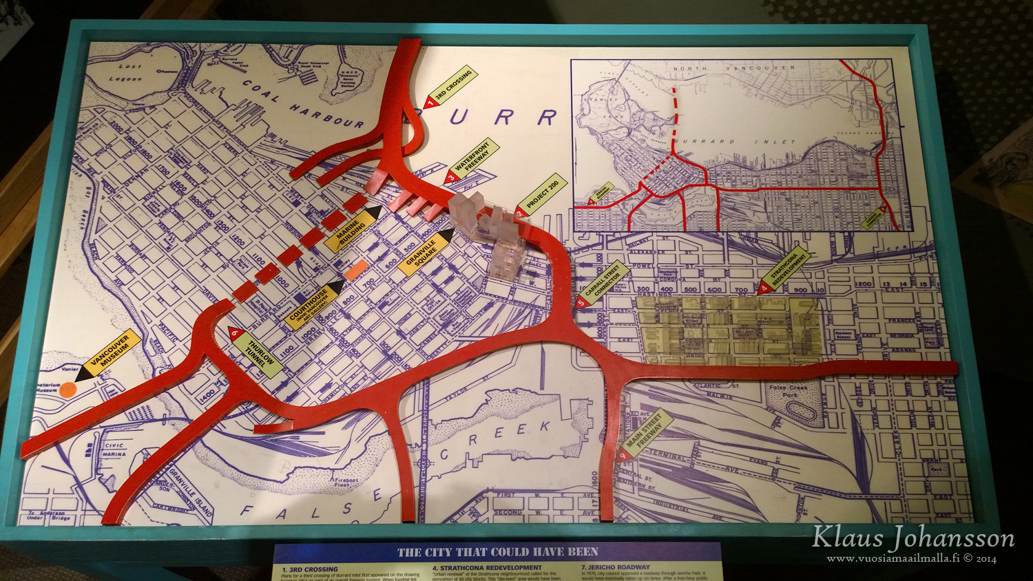
An Arbutus freeway is also mentioned in this Spacing article which is consistent with the map above. The article says that the Main St. north-south and the Grandview east-west proposals were the ones that moved forward in 1967. Granville Bridge was built before that time at about the time of the earlier studies. The author of the Spacing article suggests (but can't confirm) that Granville Bridge was intended to join an east-west / Arbutus freeway as studied earlier.

Quote:
... In 1954, Vancouver established the Technical Committee for Metropolitan Planning, consisting of the City, surrounding municipalities, and the provincial government. It created the 1959 opus ‘Freeways with Rapid Transit’, that advocated for a $450 million master plan that would carve four freeways through Vancouver, converging downtown. The freeways would cut along the Arbutus Corridor from the south and along First Avenue from the east, to meet up in downtown Vancouver before crossing to the North Shore along the Lions Gate Bridge route.

...
Rail-Rapid Transit for Metropolitan Vancouver was followed in 1964 by A Review of Transportation Plans, which regurgitated the findings of the 1959 and 1962 studies, as well as proposing a 20-year financial formula for freeways, funded by all three levels of government. The famous Vancouver Transportation Study of June 1967, with its proposals for a north-south freeway and and east-west freeway cutting through Chinatown, were met with huge public protests when city council approved its recommendations.
...
http://spacing.ca/vancouver/2010/07/14/freeways-funding-and-a-flawed-1962-rail-plan-for-vancouver/

This one shows just transit down Arbutus, but also shows an east-west freeway (blue) to just west of Granville Island.
It also shows the north-south freeway along Cambie St., rather than the 1967 plan along Ontario St.


https://www.flickr.com/photos/afiler/4050417141


https://www.flickr.com/photos/afiler/4050416731/in/photostream/


https://www.flickr.com/photos/afiler/4051160058/in/album-72157622677286308/

Last edited by officedweller; Dec 24, 2015 at 7:13 AM.
Reply With Quote
     
     
  #1415  
Old Posted Dec 24, 2015, 6:56 AM
Klazu's Avatar
Klazu Klazu is offline
Registered User
 
Join Date: Apr 2012
Location: Above Metro Vancouver clouds
Posts: 10,394
Interesting. I have never seen a plan that would have had two freeways connecting with Highway 1. Area around Downtown was also supposed to have a lot more freeways.

Reply With Quote
     
     
  #1416  
Old Posted Dec 24, 2015, 7:05 AM
Stingray2004's Avatar
Stingray2004 Stingray2004 is offline
Registered User
 
Join Date: Jan 2004
Location: White Rock, BC (Metro Vancouver)
Posts: 3,145
Quote:
Originally Posted by officedweller View Post
Probably not to the extent it was actually designed, but it was studied and proposed.

This page cites a 1964 freeway plan/study that has an east-west freeway:
From memory:

1. 1950s plan thru West End to north shore via new 3rd crossing - just conceptual - not incorporating GSB;

2. 1964 plan:

A. Arbutus Corridor - north/south;
B. 16th Ave. corridor - east/west;
C. Offshore English Bay? to north shore via new 3rd crossing; (15 years after GSB conceptualization);

3. Then the 1967 plan. And the 1968 plan. And the 1970 plan.

These involved, among others:

1. Utilizing Main Street as a north/south corridor;
2. Utilizing the Union/Prior corridor as an east/west connector to Hwy 1;
3. The Taylor Expressway along north False Creek to connect with the new Georgia viaducts;
4. The Van City Waterfront Fwy for a new 3rd crossing (connecting to Union/Prior);
5. Utilizing the Grandview Cut as east-west corridor (last freeway proposal in Van City and I even posted conceptual pics of same years back);

And on and on. The numerous freeway proposals/concepts and different annual plans were literally mind-boggling.

That said, I will again re-iterate that when the new GSB was proposed and designed back circa 1950 and opened in 1954 by then Mayor Fred Hume... it was not on any radar screen as part of a future freeway. Seriously. Just good future transportation planning. That is all.
Reply With Quote
     
     
  #1417  
Old Posted Dec 24, 2015, 7:12 AM
Stingray2004's Avatar
Stingray2004 Stingray2004 is offline
Registered User
 
Join Date: Jan 2004
Location: White Rock, BC (Metro Vancouver)
Posts: 3,145
Quote:
Originally Posted by Klazu View Post
Interesting. I have never seen a plan that would have had two freeways connecting with Highway 1. Area around Downtown was also supposed to have a lot more freeways.
I believe that is the 1968 plan incorporating Thurlow as an underground Tunnel connection to a new 3rd crossing as well as the proposed Taylor Expressway along north False Creek.

While it also shows the GSB as a freeway connection, that is 18 years after the fact. Again, never conceptualized that the GSB would be part of any so-called freeway network when it was first proposed and finally built. That said, it would certainly have fit right in based upon design.

PS. After reviewing the previous posts, the key Van City freeway proposals/plans were in 1959, 1964, 1967, 1968, and 1970 IIRC. Again, well after the initial construction of the GSB, circa 1950, with its 1954 completion date.

Last edited by Stingray2004; Dec 24, 2015 at 7:35 AM.
Reply With Quote
     
     
  #1418  
Old Posted Dec 24, 2015, 7:36 AM
officedweller officedweller is offline
Registered User
 
Join Date: Jul 2001
Location: Vancouver
Posts: 41,500
Quote:
Originally Posted by Stingray2004 View Post
That said, I will again re-iterate that when the new GSB was proposed and designed back circa 1950 and opened in 1954 by then Mayor Fred Hume... it was not on any radar screen as part of a future freeway. Seriously. Just good future transportation planning. That is all.
Yeah, back then you probably didn't have to justify future contingencies, the way that these things are cost-analysed with projections, etc. nowadays.
Reply With Quote
     
     
  #1419  
Old Posted Dec 24, 2015, 8:54 AM
aberdeen5698's Avatar
aberdeen5698 aberdeen5698 is offline
Registered User
 
Join Date: May 2010
Posts: 4,776
Quote:
Originally Posted by Stingray2004 View Post
Absolutely incorrect. Look, I am familiar with every freeway proposal in Van City since 1950. Even prepared a UBC paper on same back in my day. To be fair, I have read some folk make the same statement, over the years, for whatever reason... but that has always been a falsehood.
It wasn't designed to fit in with a specific freeway plan, it was designed so that it could connect to a freeway that might be planned in the future. The 1950's was an era where it was pretty much assumed that there would be freeways into downtown sooner or later, so the "forward thinking" of the time was "let's make sure it can accommodate a freeway".
Reply With Quote
     
     
  #1420  
Old Posted Dec 24, 2015, 9:24 AM
Pinion Pinion is offline
See ya down under, mates
 
Join Date: Jul 2007
Posts: 5,167
Why was a third Burrard Inlet crossing considered many decades ago but now it's considered impossible?
Reply With Quote
     
     
This discussion thread continues

Use the page links to the lower-right to go to the next page for additional posts
 
 
Reply

Go Back   SkyscraperPage Forum > Regional Sections > Canada > Alberta & British Columbia > Vancouver > Transportation & Infrastructure
Forum Jump


Forum Jump


All times are GMT. The time now is 8:17 AM.

     
SkyscraperPage.com - Privacy Statement - Top

Powered by vBulletin® Version 3.8.7
Copyright ©2000 - 2026, vBulletin Solutions, Inc.