HomeDiagramsDatabaseMapsForum About
     

Go Back   SkyscraperPage Forum > Regional Sections > Canada > Alberta & British Columbia > Vancouver > Transportation & Infrastructure


Reply

 
Thread Tools Display Modes
     
     
  #1381  
Old Posted Dec 23, 2015, 1:59 AM
The_Henry_Man The_Henry_Man is offline
HA
 
Join Date: Mar 2006
Location: St. Cloud, MN/Richmond, BC
Posts: 873
Quote:
Originally Posted by Stingray2004 View Post
That`s certainly an interesting concept. However, back in the day, No. 5 Road was basically a farming area with also a large Drive-In Movie Theatre, if I recall my history.

Today, south of Bridgeport Road is basically residential while north of Bridgeport Road is industrial. One would need to concurrently punch a freeway standard connector to Hwy 99 through that long stretch and I doubt that it would be feasible.

I would think that a bridge connecting Cambie could be feasible as a concept down the road - with a much shorter route (via viaduct) to connect with Hwy 99.

As an aside, over the years, have had extreme difficulty locating pics of the old Fraser Street Bridge that ya mentioned. In fact there were apparently two - a shorter, steel, swing-span connecting Mitchell Island with Van City and a second larger, wooden trestle structure connecting Mitchell Island with Richmond.

Here`s a pic of the southern, wooden structure facing north landing on Mitchell Island (circa mid-1950`s - posted on SSP about 5 years ago):


And here`s a pic from the 1940`s looking north:


And a final pic from 1962 facing NW:


Source: Garry Cullen - FB
Wow, interesting! Thanks for the pics.

To be honest with you, after looking at Google Maps, it looks like it's possible to create the No.5 Rd bridge in a way as to completely prevent bridge bottlenecks in the first place. If the bridge is 4 lanes in width, with proper separated bike lanes, has ZERO interchanges, and treated as merely an extension south from Fraser and north from No.5, I think it will be an excellent alternate route to escape the traffic nightmare from KSB, especially if the bridge bans truck traffic.

You're right regarding the freeway connection on this corridor. IMO, it's pretty much an overkill. Plus, extensive residential development on that corridor for the past 25-30 years have precluded this possibility.
Reply With Quote
     
     
  #1382  
Old Posted Dec 23, 2015, 2:17 AM
Stingray2004's Avatar
Stingray2004 Stingray2004 is offline
Registered User
 
Join Date: Jan 2004
Location: White Rock, BC (Metro Vancouver)
Posts: 3,145
Quote:
Originally Posted by WarrenC12 View Post
Who are these mythical radical left straw men you are creating? The NDP spent a ton of money building a giant highway on the island in the 90s. They did the same short-sighted vote buying that the BC Liberals are doing.
Haha. Common knowledge, across all political circles across Canada that Grand Central Station/Ground Zero for the fringe loony-left enviro movement is none other than Van City proper itself.

As for the Island Highway, not quite correct:

1. Back in the late 1980`s, the then Socred gov`t had design plans in place to construct the new Island Highway from Victoria to Campbell River with a combined freeway standard/expressway standard deign.

The Socreds also were intent on upgrading Hwy 17 (Pat Bay Hwy) to an expressway standard design. In fact, construction had already been well underway on the Island Highway, north of Parksville, by the time the BC NDP was elected gov`t back in October, 1991;

2. So what happened when the BC NDP came in?

A. They stopped construction of the Inland Island Highway. Only re-commenced construction about 1 - 2 years later;

B. The BC NDP then incorporated their typical social engineering model in terms of labour contract requirements, etc., which resulted in exploding construction costs;

C. The BC NDP downgraded the portion south of Nanaimo toward the Malahat from expressway standard to arterial standard as a result of these cost-overruns;

D. Due to the screaming from the loony-left enviro crowd, the BC NDP abandoned plans to upgrade through the Malahat portion. Even today the Malahat is a mess - numerous major accidents with major closures are routine;

E. Due to the screaming from the loony-left enviro crowd, the BC NDP abandoned an interchange at MacKenzie and Hwy 1 in the Victoria area; Had been a major traffic irritant for the Western Communities. Only now, after about 20 years, the current BC gov`t and feds have committed $85 million for an interchange to be finally built there. Loony-left enviros be damned.

F. Again, due to the screams coming from the loony-left enviro crowd, the BC NDP nixed upgrading Hwy 17 to expressway standard;

Good friggin` grief. What an effin` mess the Island Project was along with the then incumbent gov`t.

BTW, loony-left enviros are a different animal when compared to environmentally-conscious folk - which most people are. And loony-left enviros are not only part of the BC NDP base but also infest the party itself.
Reply With Quote
     
     
  #1383  
Old Posted Dec 23, 2015, 3:14 AM
SOSS SOSS is offline
Registered User
 
Join Date: Jan 2014
Posts: 661
Quote:
Originally Posted by The_Henry_Man View Post
If successive provincial governments made constant but incremental road infrastructure upgrades throughout the past 50 years, we wouldn't need to pay dearly for single massive road projects.
I think this is a fantastic statement. What is needed is a long-term nonpartisan plan set in place for setting priorities and also for annual funding amounts. Perhaps with revisiting the plan every 10 years regardless of who is in power.

One can only imagine if provincial parties and municipalities worked together to create a long-term plan (not vision) and stuck to that plan. One can only imagine if $500,000 in today's dollars was invested annually on four-laning the TCH from Kamloops to the Alberta border post Coquihalla Hwy construction. Or $500,000 in today's dollars was invested annually on lower mainland roads. - have a big expensive project that needs to get built (akin to Kicking Horse Canyon, PMB replacement, SFPR? well cut back a few years to make it happen. Average out the annual spending to some figure, revisit plan and funding every 10 years.
Reply With Quote
     
     
  #1384  
Old Posted Dec 23, 2015, 4:22 AM
libtard's Avatar
libtard libtard is offline
Dahvie Fan
 
Join Date: Aug 2012
Posts: 1,307
There has literally not been a time since 1986 that a new skytrain line hasn't been under construction. And the frequency of buses has quadrupled since then. What more do transit folks want
Reply With Quote
     
     
  #1385  
Old Posted Dec 23, 2015, 4:30 AM
cabotp cabotp is offline
Registered User
 
Join Date: Mar 2009
Location: Vancouver, BC
Posts: 2,813
Quote:
Originally Posted by The_Henry_Man View Post
I think a potential bridge connecting No.5 Rd to Fraser would be a better idea than the one on No.8 Rd. That's going to take a great idea of traffic away from OSB and KSB. Also, there's no ALR issue to contend with, since the bridge goes over mostly industrial land. Heck, before the KSB was built, the No.5 Rd bridge was THE bridge connecting Richmond to East Van.

However, if the No.5 Rd bridge becomes a reality, I wonder how it's going to navigate around all the warehouses and other buildings in Mitchell Island.
Not sure if you use the knight street bridge on a daily basis. But a lot of vehicles heading northbound take the marine drive exit and go east bound. Which tells me that a crossing at No 8 / Boundary is needed far more than a crossing at No 5 / Fraser. Also No 5 / Fraser is a bit too close to the knight street bridge. It would be better to just build a bigger knight street bridge instead.

As for the new GMT crossing I do support it. But I also wonder what impact in terms of increased traffic it will cause on the Oak / Knight bridge crossing.
Reply With Quote
     
     
  #1386  
Old Posted Dec 23, 2015, 5:30 AM
The_Henry_Man The_Henry_Man is offline
HA
 
Join Date: Mar 2006
Location: St. Cloud, MN/Richmond, BC
Posts: 873
Quote:
Originally Posted by SOSS View Post
I think this is a fantastic statement. What is needed is a long-term nonpartisan plan set in place for setting priorities and also for annual funding amounts. Perhaps with revisiting the plan every 10 years regardless of who is in power.

One can only imagine if provincial parties and municipalities worked together to create a long-term plan (not vision) and stuck to that plan. One can only imagine if $500,000 in today's dollars was invested annually on four-laning the TCH from Kamloops to the Alberta border post Coquihalla Hwy construction. Or $500,000 in today's dollars was invested annually on lower mainland roads. - have a big expensive project that needs to get built (akin to Kicking Horse Canyon, PMB replacement, SFPR? well cut back a few years to make it happen. Average out the annual spending to some figure, revisit plan and funding every 10 years.
Absolutely! In fact I would actually largely blame the massive costs for both Gateway Project and the upcoming GMT replacement Project on previous provincial governments' (esp on BC NDP, and various far-left enviro nutjobs occupying municipal governments) lack of commitment to consistent, incremental road infrastructure improvements for the past 40 years.
Reply With Quote
     
     
  #1387  
Old Posted Dec 23, 2015, 5:42 AM
The_Henry_Man The_Henry_Man is offline
HA
 
Join Date: Mar 2006
Location: St. Cloud, MN/Richmond, BC
Posts: 873
Quote:
Originally Posted by cabotp View Post
Not sure if you use the knight street bridge on a daily basis. But a lot of vehicles heading northbound take the marine drive exit and go east bound. Which tells me that a crossing at No 8 / Boundary is needed far more than a crossing at No 5 / Fraser. Also No 5 / Fraser is a bit too close to the knight street bridge. It would be better to just build a bigger knight street bridge instead.

As for the new GMT crossing I do support it. But I also wonder what impact in terms of increased traffic it will cause on the Oak / Knight bridge crossing.
Actually, you're right. I go on KSB probably once or twice a week. In fact, I think there's more traffic exiting KSB to SE Marine eastbound than the actual traffic continuing onto Knight St NB. I think the best solution is to widen KSB (doable?) to 4 lanes NB and 3 lanes SB, so that there can be two lanes exiting to SE Marine EB. Ideally, the interchange at KSB and SE Marine should be rebuilt in a way that can eliminate traffic lights and yield spots in that location (namely the left turn from SE Marine WB to KSB and yield spot for traffic entering EB SE Marine from KSB).

The No.8 Rd Bridge would be ideal but I highly doubt it can go forward politically because Richmond City Council passed a resolution objecting to the new bridge connecting the 91 with the 17. Very unfortunate. However, in order to preserve the ALR, can't they build it via No.8 Rd on pilings and viaducts throughout?
Reply With Quote
     
     
  #1388  
Old Posted Dec 23, 2015, 3:34 PM
Klazu's Avatar
Klazu Klazu is offline
Registered User
 
Join Date: Apr 2012
Location: Above Metro Vancouver clouds
Posts: 10,397
Quote:
Originally Posted by aberdeen5698 View Post
Because there are more cars heading in the counterflow lane direction than in the opposite (minority) direction. If you didn't have the counterflow lane then presumably the backup would be worse in the direction most people are going.
I know that, but the question was why not change the counter-flow direction few times during rush hour, like they do on Lions Gate Bridge? Currently it feels like rush hour direction is getting too much priority and is smooth sailing, whereas the other direction is almost standing still.

Also, why have they never implemented counter-flow on Alex Fraser Bridge? The bridge has excessive capacity and could easily serve in 4+2 lane configuration during rush hour. Has this even been considered?
Reply With Quote
     
     
  #1389  
Old Posted Dec 23, 2015, 3:56 PM
WarrenC12's Avatar
WarrenC12 WarrenC12 is offline
Registered User
 
Join Date: May 2007
Location: East OV!
Posts: 24,559
Quote:
Originally Posted by Klazu View Post
I know that, but the question was why not change the counter-flow direction few times during rush hour, like they do on Lions Gate Bridge? Currently it feels like rush hour direction is getting too much priority and is smooth sailing, whereas the other direction is almost standing still.

Also, why have they never implemented counter-flow on Alex Fraser Bridge? The bridge has excessive capacity and could easily serve in 4+2 lane configuration during rush hour. Has this even been considered?
The AFB area has too much traffic separation (which is good, because it's safer) so counterflow would require a number of serious construction changes.

As for the GMT, I don't know the answer there. 1 lane is just too much of a bottleneck. But a solution is in the works, so just 7 short years to wait...
Reply With Quote
     
     
  #1390  
Old Posted Dec 23, 2015, 4:11 PM
trofirhen trofirhen is offline
Registered User
 
Join Date: Oct 2008
Posts: 9,043
Quote:
Originally Posted by Klazu View Post
I know that, but the question was why not change the counter-flow direction ..............................
Also, why have they never implemented counter-flow on Alex Fraser Bridge? The bridge has excessive capacity and could easily serve in 4+2 lane configuration during rush hour. Has this even been considered?
They do that on the Bosphorus Bridge in Istanbul, and it seems to work well.
However, as Warren implied, perhaps it's wider than the AFB (though it seemed about the same to me)

Last edited by trofirhen; Dec 23, 2015 at 4:22 PM.
Reply With Quote
     
     
  #1391  
Old Posted Dec 23, 2015, 5:01 PM
aberdeen5698's Avatar
aberdeen5698 aberdeen5698 is offline
Registered User
 
Join Date: May 2010
Posts: 4,778
Quote:
Originally Posted by Klazu View Post
I know that, but the question was why not change the counter-flow direction few times during rush hour, like they do on Lions Gate Bridge? Currently it feels like rush hour direction is getting too much priority and is smooth sailing, whereas the other direction is almost standing still.
Given the amount of time it takes to safely open and close the counterflow lane and the time it takes backlogs like that to clear I'm kind of skeptical that it would be a net improvement.
Reply With Quote
     
     
  #1392  
Old Posted Dec 23, 2015, 7:44 PM
Klazu's Avatar
Klazu Klazu is offline
Registered User
 
Join Date: Apr 2012
Location: Above Metro Vancouver clouds
Posts: 10,397
Quote:
Originally Posted by aberdeen5698 View Post
Given the amount of time it takes to safely open and close the counterflow lane and the time it takes backlogs like that to clear I'm kind of skeptical that it would be a net improvement.
It is actually a valid point that with the tunnel the traffic cannot be made to merge back to normal lanes like on Lions Gate Bridge, so switching the direction is not as smooth to implement. Maybe it is not worth it due to that.

In regards to Alex Fraser Bridge, sure, they would need to do some re-building to accommodate counter-flow, but it doesn't seem like that difficult job and I don't see how it could not be implemented in same fashion as on GMT. It would work better northbound, where the highway splits and provides extra lanes, whereas southwards the help from fourth lane would be less.
Reply With Quote
     
     
  #1393  
Old Posted Dec 23, 2015, 8:36 PM
Rico Rico is offline
Registered User
 
Join Date: Feb 2012
Posts: 319
To me it seems the need for 10 lanes for the GMT is bizzare, especially if it is tolled which will keep traffic volumes down. What I wonder is if a 7 lane configuration was ever considered with a single permanently separated Bus only lane in the center that acts like the counter flow. Rush hour buses get their own lane, counter flow buses (that would not be in congestion with 3 lanes) use the regular lanes. I think people underestimate how much tolling this bridge will reduce demand. Have volumes going over the new Port Mann caught up to the pre-toll levels on the old Port Mann yet?
Reply With Quote
     
     
  #1394  
Old Posted Dec 23, 2015, 9:08 PM
WarrenC12's Avatar
WarrenC12 WarrenC12 is offline
Registered User
 
Join Date: May 2007
Location: East OV!
Posts: 24,559
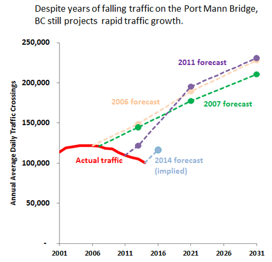
PMB Volumes are a bit of a joke. 2015-16 should provide the high end of any forecasts, as we have good economic growth and really cheap gas.

Reply With Quote
     
     
  #1395  
Old Posted Dec 23, 2015, 10:02 PM
Klazu's Avatar
Klazu Klazu is offline
Registered User
 
Join Date: Apr 2012
Location: Above Metro Vancouver clouds
Posts: 10,397
What's the point of touting an old, non-official and un-sourced graph in here? Don't we already know that the volumes have remained at least stable in 2014 and 2015, if not started climbing again?

Everyone also knows that the originally estimated volumes would happen the next day if the toll was removed or even lowered. People are just so cheap with their time, so they spend an hour in Pattullo queues. Idiotic, if you ask me.

Lastly, the bridge is already there and it is not going anywhere, so there is no point in keep crying about it.
Reply With Quote
     
     
  #1396  
Old Posted Dec 23, 2015, 10:06 PM
WarrenC12's Avatar
WarrenC12 WarrenC12 is offline
Registered User
 
Join Date: May 2007
Location: East OV!
Posts: 24,559
Here's the source:

http://thetyee.ca/Blogs/TheHook/2014/02/14/Port-Mann-Delusions/

I was responding to the topic brought up.

I think a very recent 10-lane toll bridge has incredible relevance when the province is committed to building exactly the same type of infrastructure again for this bridge.

Here's the official source of volumes, not in graphical form:

http://www.pmh1project.com/about-the-project/about-ti-corp/Pages/Traffic.aspx
Reply With Quote
     
     
  #1397  
Old Posted Dec 23, 2015, 10:09 PM
Klazu's Avatar
Klazu Klazu is offline
Registered User
 
Join Date: Apr 2012
Location: Above Metro Vancouver clouds
Posts: 10,397
Thanks. Strange that they don't put their name on their graphs.

Nonetheless, it would be good to have real 2014 and 2015 figures, as that one is strongly suggesting a declining trend, which I doubt is the case. The growth is just happening much slower than they anticipated due to people being cheap.
Reply With Quote
     
     
  #1398  
Old Posted Dec 23, 2015, 10:25 PM
aberdeen5698's Avatar
aberdeen5698 aberdeen5698 is offline
Registered User
 
Join Date: May 2010
Posts: 4,778
Quote:
Originally Posted by Klazu View Post
...it would be good to have real 2014 and 2015 figures, as that one is strongly suggesting a declining trend, which I doubt is the case. The growth is just happening much slower than they anticipated due to people being cheap.
Actually, traffic was declining for five years before the tolls were implemented (and declines started before the financial crisis), and yet the 2011 forecast still called for a huge increase in traffic volumes which would result in higher traffic levels than the original, discredited 2006 and 2007 forecasts. This is known as "wearing blinkers".

It's not just BC that's making this mistake - it's common among highway engineers all over the Western Hemisphere. Of course it's in the best interests of highway engineers for traffic volumes to rise, but at some point we have to come to the realization that "fool me twice, shame on us".

This is exactly why people are questioning the need for 10 lanes. Unfortunately the GMT replacement will already be built by the time we know for sure whether this is just a blip or if the habits of the younger generation are really creating a lasting turning point with regard to car usage.
Reply With Quote
     
     
  #1399  
Old Posted Dec 23, 2015, 11:01 PM
Stingray2004's Avatar
Stingray2004 Stingray2004 is offline
Registered User
 
Join Date: Jan 2004
Location: White Rock, BC (Metro Vancouver)
Posts: 3,145
Quote:
Originally Posted by WarrenC12 View Post
Haha. Ya do realize that the Tyee is not a credible source?! For anything. It`s akin to Sun media except for being on the opposite end of the political spectrum.

In any event, here are the latest PMB figures available:

Quote:
Port Mann Bridge traffic sees 5% increase

AUGUST 26, 2015

Traffic figures on the new 10-lane Port Mann Bridge have experienced consecutive monthly increases, according to new data provided by the Transportation Investment Corporation.

During the first seven months of 2015, the tolled crossing recorded 20.73 million trips, an uptick of five per cent over the same period experienced last year.

The weekday average in July 2015 was 3.24 million, which is 60,000 more vehicles than what was recorded in July 2014. On a daily average basis, 111,800 vehicles were recorded on each weekday in July compared to 107,700 vehicles during the same month in 2014.

“We’ve seen seven or eight consecutive months of year-over-year growth. On average, traffic volumes have been six per cent higher every month this year than the year before.”
http://www.vancitybuzz.com/2015/08/port-mann-bridge-traffic-increase/

PS. The other link that ya posted shows latest to November, 2015 and, since September, 2015 actually shows greater growth over two years even since July.
Reply With Quote
     
     
  #1400  
Old Posted Dec 23, 2015, 11:33 PM
moosejaw moosejaw is offline
Registered User
 
Join Date: Apr 2012
Location: Miami
Posts: 482
In response to the counter flow lanes on the AFB, a similar system that's in place in Honolulu and San Juan where they use a zipper dual jersey barrier with a modified bus that moves the median to suit traffic flow patterns
. Pretty neat if you ask me
Reply With Quote
     
     
This discussion thread continues

Use the page links to the lower-right to go to the next page for additional posts
 
 
Reply

Go Back   SkyscraperPage Forum > Regional Sections > Canada > Alberta & British Columbia > Vancouver > Transportation & Infrastructure
Forum Jump


Forum Jump


All times are GMT. The time now is 3:04 PM.

     
SkyscraperPage.com - Privacy Statement - Top

Powered by vBulletin® Version 3.8.7
Copyright ©2000 - 2026, vBulletin Solutions, Inc.