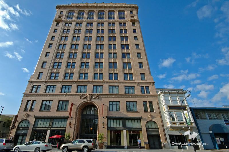
That's a building in the central business district, west of 15th Street--which is an area with no maximum height limit. So, yes, a building this high is perfectly appropriate in this zone, but not so much on 25th Street in Midtown. Time for another graphic.
Here's a copy of the central city land-use map, which shows the land use and intensity for each area as defined by the city's General Plan. The General Plan is what drives the zoning code, and it's the set of rules that the Planning Commission and City Council are supposed to follow when making decisions about what gets built where. This isn't Houston, where there is no zoning code--every city in the United States has zoning codes and maximum heights and general plans.

And here's a handy guide that tells you what all the colors and patterns mean in terms of recommended density and height.

The areas indicated in red and burgundy are designated "Urban Center High" and "Central Business District." You can see what areas they include--generally west of 15th Street and north of Q Street, into the Railyards, Richards Boulevard and Docks areas. Pretty much any vacant lot in there would be a great place for Yamanee--such as the city's currently-vacant hole at 8th and K, which, as I recall, they were trying to find a developer to fill.
The pink areas with diagonal stripes are urban corridors, which come in two flavors--"Urban Corridor High" and "Urban Corridor Low." The "High" kind are the sort you see on 16th Street near Fremont Park, L Street out to 19th, and along 29th Street where the Sutter hospital complex is located. Those are intended for midrise buildings up to about 10-12 stories, and that's what you find there. The CADA properties developed along 16th Street are a bit lower than that maximum for the most part, but they're within that range. The "Low" kind is what J/K/L in Midtown are zoned for--3-6 stories. Not everything along J Street is 3-6 stories, because part of the purpose of the general plan is to leave room for growth. The 6 story building planned for 21st and Q Street, for example, fits within that zoning category so there is no need for the developer to ask for an increase of the height limit or a general plan amendment. On either side of that urban corridor along J, K and L Street are residential neighborhoods, like Boulevard Park and Marshall School to the north, and Midtown itself to the south. These are lower in max height than the urban corridors, typically 3 stories max, but there is a lot of population density because it's mostly multi-unit residential.
I wouldn't consider 6 stories "out of scale" on the 2500 block of J Street, and neither does the zoning code--note the maximum allowed height here is just under 80 feet. The graphic I posted is pretty much to scale, using a scale of 40 feet = 1 inch in both vertical and horizontal. I topped the scale at 200 feet in order to fit the 180 foot max height of Yamanee into the image.
So, just because a lot is on J Street doesn't mean it is a perfect place for high-rise buildings--because J Street runs through most of the city, through many different kinds of neighborhoods with different intensities of use. And there are plenty of places for a project like Yamanee--not an unknown, ambiguous "Somewhere Else," but a pretty large swath of the city that a team of city government, residents, businesses and builders/developers agreed upon as a place to go tall.
The General Plan isn't hatched up in a secret room. It's a public process that is driven by city staff, with a board that is made up of citizens, businesspeople
and a strong representation by the development community. The purpose of the plan is to limit ambiguity about what is allowed where, which is important to the development community, as they want to know what uses are allowed on which lots in which parts of town, and for many projects, it's also important to know what isn't allowed there. Developers and builders have a very strong hand in creating this document, and they have a stake in its viability and predictability.





 Prev
Prev




 Linear Mode
