HomeDiagramsDatabaseMapsForum About
     

Go Back   SkyscraperPage Forum > Regional Sections > Canada > Alberta & British Columbia > Vancouver > Transportation & Infrastructure


Reply

 
Thread Tools Display Modes
     
     
  #3721  
Old Posted Sep 17, 2015, 3:22 PM
WarrenC12's Avatar
WarrenC12 WarrenC12 is offline
Registered User
 
Join Date: May 2007
Location: East OV!
Posts: 24,682
Is there any map of the Tsawassen upgrades available?
Reply With Quote
     
     
  #3722  
Old Posted Sep 17, 2015, 4:30 PM
CanSpice's Avatar
CanSpice CanSpice is offline
Registered User
 
Join Date: Dec 2014
Location: New Westminster, BC
Posts: 2,728
Quote:
Originally Posted by Large Cat View Post
Glad to see the Sapperton upgrades too. New West is plugging along on connecting its waterfront. Fingers crossed that Cote accomplishes it during his term.
It probably won't happen any time soon because of the businesses that are along Front Street between Pier Park and Sapperton Landing. They'd have to go first for a proper waterfront connection between those two.

Or they could put a boardwalk on the other side of Front Street with pedestrian bridges connecting everything, but then it wouldn't be waterfront any more. And it'd probably be pricey, and if they wanted to put elevators in then it'd take forever and a day.
Reply With Quote
     
     
  #3723  
Old Posted Sep 18, 2015, 6:10 PM
tybuilding tybuilding is offline
Registered User
 
Join Date: Sep 2009
Posts: 898
Repaved BC Parkway in New Westminster along Stewartson Way

Last edited by tybuilding; Sep 19, 2015 at 4:41 AM.
Reply With Quote
     
     
  #3724  
Old Posted Sep 18, 2015, 6:37 PM
tybuilding tybuilding is offline
Registered User
 
Join Date: Sep 2009
Posts: 898
Surrey's first separated bike lanes are being built on 105 Ave in City Centre


Last edited by tybuilding; Sep 19, 2015 at 4:43 AM.
Reply With Quote
     
     
  #3725  
Old Posted Oct 7, 2015, 9:34 PM
Klazu's Avatar
Klazu Klazu is offline
Registered User
 
Join Date: Apr 2012
Location: Above Metro Vancouver clouds
Posts: 10,408
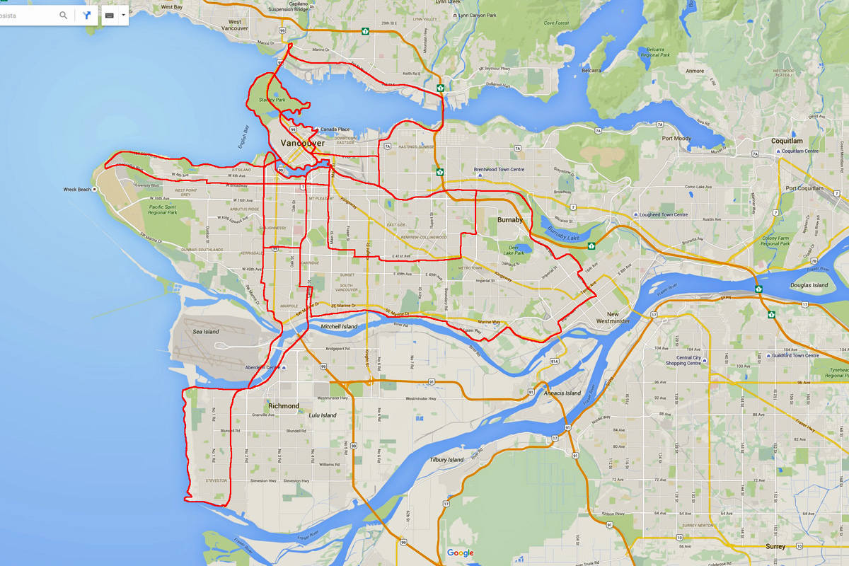
I have been taking a good use of our biking infrastructure this summer. Last week's great weather got me to do a bit over 200km in 7 days with trips to Steveston (54km) and Westminster (51km) being the longest day trips. I also made my personal record to go around the Seawall (18km) in 48 minutes. Note, these are all leisure trips.

Based on my experience we have a great biking infrastructure that is easy to use and pretty well thought out (in terms of steepness). There could be more maps around major intersections as it is sometimes difficult to find some specific bikeway especially around the Central Valley Greenway. They should also replace the map next to Brentwood Home Depot, which some idiot has vandalized.

Last week (200km).


This summer (500km+)


Next I need to expand my horizon. Weather permitted, I still plan on doing a run from Downtown to Coquitlam and back, as well as Tour de Richmond. Any other nice paths you like?
Reply With Quote
     
     
  #3726  
Old Posted Oct 7, 2015, 11:16 PM
aberdeen5698's Avatar
aberdeen5698 aberdeen5698 is offline
Registered User
 
Join Date: May 2010
Posts: 4,793
Quote:
Originally Posted by Klazu View Post
Last week (200km).
Looks like a very nice set of trips you've taken there.

I just wanted to point out that you didn't have to bike that small stretch along 41st Avenue if you didn't have a reason to be there. There's a nice bike route along 45th Avenue that has minimal hills in that area. I often use it in place of the hillier 38th Avenue route even if it takes me a bit out of my way.
Reply With Quote
     
     
  #3727  
Old Posted Oct 8, 2015, 1:45 AM
Klazu's Avatar
Klazu Klazu is offline
Registered User
 
Join Date: Apr 2012
Location: Above Metro Vancouver clouds
Posts: 10,408
That's actually not a GPS track, but just me drawing on map.

But you have good eyes. I actually took Ridgeway from Metrotown to Ontario, but couldn't remember how exactly it travels from that zoom level. It's a nice and gentle ride mostly downhill.
Reply With Quote
     
     
  #3728  
Old Posted Oct 8, 2015, 3:45 AM
Large Cat's Avatar
Large Cat Large Cat is offline
Vancouver Bus Driver
 
Join Date: Oct 2014
Location: Vancouver, BC
Posts: 396
Quote:
Originally Posted by tybuilding View Post
Surrey's first separated bike lanes are being built on 105 Ave in City Centre

I would love to see these photos, but they seem to be down!
Reply With Quote
     
     
  #3729  
Old Posted Oct 8, 2015, 9:16 PM
officedweller officedweller is offline
Registered User
 
Join Date: Jul 2001
Location: Vancouver
Posts: 41,749
Pics of work on the Stanley Park Causeway bike path here:

https://www.flickr.com/photos/tranbc/sets/72157658257710368

The post in the middle of the path looks to be for the lane control signals.


https://www.flickr.com/photos/tranbc/sets/72157658257710368


https://www.flickr.com/photos/tranbc/sets/72157658257710368
Reply With Quote
     
     
  #3730  
Old Posted Oct 9, 2015, 7:04 AM
TransitJack TransitJack is offline
Registered User
 
Join Date: Jul 2009
Posts: 443
Quote:
Originally Posted by officedweller View Post
Pics of work on the Stanley Park Causeway bike path here:

https://www.flickr.com/photos/tranbc/sets/72157658257710368

The post in the middle of the path looks to be for the lane control signals.


https://www.flickr.com/photos/tranbc/sets/72157658257710368


https://www.flickr.com/photos/tranbc/sets/72157658257710368
Cyclists will use the existing sidewalk, and pedestrians will use the new blacktop?
Reply With Quote
     
     
  #3731  
Old Posted Oct 9, 2015, 3:11 PM
Klazu's Avatar
Klazu Klazu is offline
Registered User
 
Join Date: Apr 2012
Location: Above Metro Vancouver clouds
Posts: 10,408
Correct
Reply With Quote
     
     
  #3732  
Old Posted Oct 9, 2015, 3:47 PM
TransitJack TransitJack is offline
Registered User
 
Join Date: Jul 2009
Posts: 443
Quote:
Originally Posted by Klazu View Post
Correct
Cost-wise that makes sense. As a cyclist, it would be nice to get the blacktop on the whole project: Way smoother than the bumps every metre on the sidewalk.

Still a massive improvement!
Reply With Quote
     
     
  #3733  
Old Posted Oct 9, 2015, 9:01 PM
idunno idunno is offline
Registered User
 
Join Date: Feb 2010
Posts: 950
There are rarely pedestrians on that stretch, so I think it'd be safe to say that cyclists could technically use the blacktop too.
Reply With Quote
     
     
  #3734  
Old Posted Oct 9, 2015, 10:31 PM
TransitJack TransitJack is offline
Registered User
 
Join Date: Jul 2009
Posts: 443
Quote:
Originally Posted by idunno View Post
There are rarely pedestrians on that stretch, so I think it'd be safe to say that cyclists could technically use the blacktop too.
Except the light posts that would be an obstacle to avoid
Reply With Quote
     
     
  #3735  
Old Posted Oct 12, 2015, 5:04 AM
Large Cat's Avatar
Large Cat Large Cat is offline
Vancouver Bus Driver
 
Join Date: Oct 2014
Location: Vancouver, BC
Posts: 396
I was surprised and aghast with joy to discover today that the city of Burnaby has begun building an urban trail along Rumble in the South Slope neighbourhood. Coinciding with road repaving, the city is upgrading the sidewalk and sidewalk letdowns on the south side of the road, and building a full-fledged multi-use pathway on the north side, including full crossbike pavement markings to help cyclists and pedestrians continue at intersections. This is something I've suggested before in this thread, citing the overabundance of gravel street parking on Rumble, and it looks like something productive is finally being done with the land. The section currently under construction, and almost complete, is between MacPherson and Gilley, and will connect to the BC Parkway multi-use pathway under the skytrain at Rumble and Gilley. I am assuming the construction will continue westward in the near future, as there is certainly space for the pathway to continue, and the road all the way to Boundary could use some repaving. That said, the Willingdon urban trail extension still hasn't begun construction, so it remains to be seen what will be done first (or both!).

Pictures to follow the next time I'm in the area.
Reply With Quote
     
     
  #3736  
Old Posted Oct 12, 2015, 5:51 AM
TransitJack TransitJack is offline
Registered User
 
Join Date: Jul 2009
Posts: 443
Quote:
Originally Posted by Large Cat View Post
I was surprised and aghast with joy to discover today that the city of Burnaby has begun building an urban trail along Rumble in the South Slope neighbourhood. Coinciding with road repaving, the city is upgrading the sidewalk and sidewalk letdowns on the south side of the road, and building a full-fledged multi-use pathway on the north side, including full crossbike pavement markings to help cyclists and pedestrians continue at intersections. This is something I've suggested before in this thread, citing the overabundance of gravel street parking on Rumble, and it looks like something productive is finally being done with the land. The section currently under construction, and almost complete, is between MacPherson and Gilley, and will connect to the BC Parkway multi-use pathway under the skytrain at Rumble and Gilley. I am assuming the construction will continue westward in the near future, as there is certainly space for the pathway to continue, and the road all the way to Boundary could use some repaving. That said, the Willingdon urban trail extension still hasn't begun construction, so it remains to be seen what will be done first (or both!).

Pictures to follow the next time I'm in the area.
I was going to ride out that way today but opted to a different plan. I often ride along Rumble. I like Rumble as a route to Queensborough Bridge. I usually drop down to Neville east of McPherson to avoid that odd gravelled shoulder section. They were doing road work/sewer work when I was last in the area.

Though I'm appreciative of a bike route/lane/path, I hope the road itself will still have space for cyclists. As a road biker, the road is where I'd prefer to be and tend to be a hazard to other users on the shared-use paths.

Sometimes cities build multi-use paths at the expensive of on-road cycling space.
Reply With Quote
     
     
  #3737  
Old Posted Oct 12, 2015, 5:58 AM
GlassCity's Avatar
GlassCity GlassCity is offline
Rational urbanist
 
Join Date: Aug 2012
Location: Metro Vancouver
Posts: 5,270
Quote:
Originally Posted by TransitJack View Post
I was going to ride out that way today but opted to a different plan. I often ride along Rumble. I like Rumble as a route to Queensborough Bridge. I usually drop down to Neville east of McPherson to avoid that odd gravelled shoulder section. They were doing road work/sewer work when I was last in the area.

Though I'm appreciative of a bike route/lane/path, I hope the road itself will still have space for cyclists. As a road biker, the road is where I'd prefer to be and tend to be a hazard to other users on the shared-use paths.

Sometimes cities build multi-use paths at the expensive of on-road cycling space.
This, shared-use paths are just an easy cop out sometimes. In downtown Ladner (I know ) they installed a shared-use path about 15 metres long, and barely wider than a standard sidewalk. Does absolutely nothing for cyclists. I'd much rather be in an on-street bike lane than a shared use pathway where I have to dodge between pedestrians. That being said, separated bike lanes would be ideal
Reply With Quote
     
     
  #3738  
Old Posted Oct 12, 2015, 3:12 PM
aberdeen5698's Avatar
aberdeen5698 aberdeen5698 is offline
Registered User
 
Join Date: May 2010
Posts: 4,793
Quote:
Originally Posted by GlassCity View Post
This, shared-use paths are just an easy cop out sometimes. In downtown Ladner (I know ) they installed a shared-use path about 15 metres long, and barely wider than a standard sidewalk. Does absolutely nothing for cyclists.
Cities often have a master plan that they are working towards but don't have a budget to fully implement. So they build these features into sections of road that have to be worked on for other reasons. Over time the plan will come to fruition. You can see this happening in places like Willingdon, where the cycle path is gradually being filled in as work is done on sections of the road.
Reply With Quote
     
     
  #3739  
Old Posted Oct 12, 2015, 5:54 PM
GlassCity's Avatar
GlassCity GlassCity is offline
Rational urbanist
 
Join Date: Aug 2012
Location: Metro Vancouver
Posts: 5,270
Quote:
Originally Posted by aberdeen5698 View Post
Cities often have a master plan that they are working towards but don't have a budget to fully implement. So they build these features into sections of road that have to be worked on for other reasons. Over time the plan will come to fruition. You can see this happening in places like Willingdon, where the cycle path is gradually being filled in as work is done on sections of the road.
You can make that argument for its length, but the width is just not good enough. If it ever does get lengthened and so actually have people use it, it would be really unsafe due to its width. It just feels like cities take a regular sidewalk and put a "shared use" sign up so they don't have to actually do anything to improve cycling, since that would usually involve taking away space from cars. Calgary had paths like this all over the city.
Reply With Quote
     
     
  #3740  
Old Posted Oct 12, 2015, 6:41 PM
Large Cat's Avatar
Large Cat Large Cat is offline
Vancouver Bus Driver
 
Join Date: Oct 2014
Location: Vancouver, BC
Posts: 396
Quote:
Originally Posted by GlassCity View Post
You can make that argument for its length, but the width is just not good enough. If it ever does get lengthened and so actually have people use it, it would be really unsafe due to its width. It just feels like cities take a regular sidewalk and put a "shared use" sign up so they don't have to actually do anything to improve cycling, since that would usually involve taking away space from cars. Calgary had paths like this all over the city.
That may be true, but in this case Burnaby IS taking space away from cars and giving it to pedestrians as well as cyclists. Previously there were NO or inadequate sidewalks on either side of the street, and literally 2 metres width of gravel parking for cars on each side. The residents couldn't possibly even use it all, even those with 3 cars per house. So this is a GREAT sign for the walkability of the neighbourhood, something Burnaby as a whole has been rather crappy on, on top of the benefit to cyclists.

On top of that, it DOES work for cyclists and pedestrians to share multi use trail in the suburbs, at least for the present. This isn't the Seawall, at least not yet lol. Cyclists just have to be willing to slow down a little bit and not act like motor vehicles. The whole BC parkway between Metrotown and 22nd St is already an example of how this can work. The more difficult aspect on Rumble honestly is that homeowners will have to obey the city and not continue parking their cars on the completed multi-use trail as they are doing at present.

Where "shared trails" don't generally work is where some or all of the following apply:

-there is no directional or instructional signage for cyclists
-the "trail" is immediately flush with the roadway and constrained on the other side by poles or trees
-the trail is made out of concrete or some uneven surface material other than asphalt
-there are no crossbike/wide crosswalk treatments at intersections where roadway must be crossed
-there is no connection at all to other multi-use pathways or adequate walking infrastructure except other sidewalks
-the trail isn't actually at the recommended width for multi use pathways

There is a lot of "shared space" in Vancouver that has these features, and I agree that usually such right of ways are useless or awkwars for cyclists. But none of these conditions apply here.

Reply With Quote
     
     
This discussion thread continues

Use the page links to the lower-right to go to the next page for additional posts
 
 
Reply

Go Back   SkyscraperPage Forum > Regional Sections > Canada > Alberta & British Columbia > Vancouver > Transportation & Infrastructure
Forum Jump


Forum Jump


All times are GMT. The time now is 11:54 PM.


Powered by vBulletin® Version 3.8.7
Copyright ©2000 - 2026, vBulletin Solutions, Inc.