HomeDiagramsDatabaseMapsForum About
     

Go Back   SkyscraperPage Forum > Global Projects & Construction > City Compilations


Reply

 
Thread Tools Display Modes
     
     
  #5501  
Old Posted Oct 4, 2013, 8:26 PM
BrianTH BrianTH is offline
Registered User
 
Join Date: Jan 2010
Posts: 6,078
Quote:
Originally Posted by DKNewYork View Post
Good question. CMOA has at least twice tried to establish a downtown outpost. I have always assumed that galleries would be what they most desire/need. They could probably use the theater (sublet it, or allow the current resident companies to continue to use it) but my guess is that any theatre would be secondary to the mission of such a downtown venture.
So offhand I see no inherent problem with preserving the most distinctive aspects of the current building, giving Carnegie more or less as much gallery space as they want, and doing a mid- or highrise with new frontage along 2/3rds or so of Liberty.

Now of course that would likely be more expensive than clearing the lot and starting over entirely. But maybe Carnegie and other non-profit powers that be could make the numbers add up for the for-profit developer partner.
Reply With Quote
     
     
  #5502  
Old Posted Oct 4, 2013, 8:29 PM
photoLith's Avatar
photoLith photoLith is offline
Ex Houstonian
 
Join Date: Feb 2008
Location: Pittsburgh n’ at
Posts: 15,998
I knew that would happen to that row house but it still sounds like they want to build an identical building on that lot.
Reply With Quote
     
     
  #5503  
Old Posted Oct 4, 2013, 8:32 PM
DKNewYork DKNewYork is offline
Registered User
 
Join Date: Jun 2013
Location: Manhattan
Posts: 500
Quote:
Originally Posted by George Woods View Post
[sigh]

Is this the Mexican War Streets house whose demolition was ostensibly stopped last week? If so, it looks like more of it came down.
Reply With Quote
     
     
  #5504  
Old Posted Oct 4, 2013, 8:36 PM
BrianTH BrianTH is offline
Registered User
 
Join Date: Jan 2010
Posts: 6,078
By the way, the section I am talking about keeping is maybe 1/6th of the total footprint, but it has to be 95% or more of what people actually associate with the building.

For a handy illustration of this point, check out the first seven or so photos on this page:

http://www.archdaily.com/163047/august-wilson-center-for-african-american-culture-perkinswill/
Reply With Quote
     
     
  #5505  
Old Posted Oct 4, 2013, 8:42 PM
George Woods George Woods is offline
Registered User
 
Join Date: Feb 2009
Posts: 99
Quote:
Great insights about the old street grid. But before anyone starts complaining about PNC: The bank played no part in the destruction of the block of Oliver Avenue (between Wood and Liberty) that was lost during the construction of what is now Two PNC Plaza. That happened when the building was built as the HQ for Equibank, long long before PNC bought the building.
Yeah, I actually didn't mean to blame PNC at all; I was merely identifying the building that currently sits where the street was. I always walk by and think about how cool it would be to look all the way up Oliver to the Mellon Building from Liberty. Not to mention, when I worked on Oliver, I always wished I could walk to Sixth Street without going around the building.


Quote:
So old Eighth Avenue was one block long?
Yeah, it only went from Cherry (William Penn) to Grant. And then, there was one final triangular lot that constituted the end of Downtown, at what is now 11th and Grant/Liberty (Federal Building). Of the eight triangular lots than dotted the length of Liberty (along with a couple that were almost triangles), only three remain: the parklet in front of the Fairmont, the Wood Street T station, and the building at Seventh and Smithfield.

Last edited by George Woods; Oct 4, 2013 at 8:55 PM.
Reply With Quote
     
     
  #5506  
Old Posted Oct 4, 2013, 8:44 PM
George Woods George Woods is offline
Registered User
 
Join Date: Feb 2009
Posts: 99
Reply With Quote
     
     
  #5507  
Old Posted Oct 4, 2013, 8:50 PM
George Woods George Woods is offline
Registered User
 
Join Date: Feb 2009
Posts: 99
Quote:
Is this the Mexican War Streets house whose demolition was ostensibly stopped last week? If so, it looks like more of it came down.
Yep. I wasn't too hopeful about the plan that was hastily put forth to save it. That guy was never gonna risk all that money. As soon as it rained, he wouldn't have been able to prove that past water-damage to the neighbor wasn't from the time he was responsible. There just wasn't sufficient time to put a roof back on and start rebuilding. Once it was exposed to the elements like that, it was pretty much fucked, given the situation with the neighbor, and the need for an individual to put up his own money. Just wasn't realistic. —.
Reply With Quote
     
     
  #5508  
Old Posted Oct 4, 2013, 8:58 PM
George Woods George Woods is offline
Registered User
 
Join Date: Feb 2009
Posts: 99
Quote:
Originally Posted by photoLith View Post
I knew that would happen to that row house but it still sounds like they want to build an identical building on that lot.

That is better than nothing. I just wish they could've saved the old bricks. They can replicate the trim, but new bricks look new. Oh, well. Who knows. The preservationists on Buena Vista are intense—maybe they persuaded whomever to save them.
Reply With Quote
     
     
  #5509  
Old Posted Oct 4, 2013, 8:58 PM
Evergrey's Avatar
Evergrey Evergrey is offline
Eurosceptic
 
Join Date: Apr 2003
Location: Pittsburgh
Posts: 24,141
Quote:
Originally Posted by George Woods View Post
Yeah, I actually didn't mean to blame PNC at all; I was merely identifying the building that currently sits where the street was. I always walk by and think about how cool it would be to look all the way up Oliver to the Mellon Building from Liberty. Not to mention, when I worked on Oliver, I always wished I could walk to Sixth Street without going around the building.


Yeah, it only went from Cherry (William Penn) to Grant. And then, there was one final triangular lot that constituted the end of Downtown, at what is now 11th and Grant/Liberty (Federal Building). Of the eight triangular lots than dotted the length of Liberty (along with a couple that were almost triangles), only three remain: the parklet in front of the Fairmont, the Wood Street T station, and the building at Seventh and Smithfield.
Usually I would agree with this viewpoint, but I really like the Oliver Superblock. While none of the modernist skyscrapers in that block are awesome individually, they come together to form a dense and powerful collection of corporate might.
Reply With Quote
     
     
  #5510  
Old Posted Oct 4, 2013, 9:02 PM
George Woods George Woods is offline
Registered User
 
Join Date: Feb 2009
Posts: 99
Quote:
Originally Posted by Evergrey View Post
Usually I would agree with this viewpoint, but I really like the Oliver Superblock. While none of the modernist skyscrapers in that block are awesome individually, they come together to form a dense and powerful collection of corporate might.
Ha. I actually agree with you. I've always been of two minds about it, really. From Liberty, I resent it. From Wood and up, it's an awesome cluster of buildings to look down Oliver at. And when you're right at the intersection of Oliver and Wood, the grouping of them to one side, and the view up Oliver to the other, make for a pretty great urban space.
Reply With Quote
     
     
  #5511  
Old Posted Oct 4, 2013, 9:41 PM
DKNewYork DKNewYork is offline
Registered User
 
Join Date: Jun 2013
Location: Manhattan
Posts: 500
Quote:
Originally Posted by Evergrey View Post
Usually I would agree with this viewpoint, but I really like the Oliver Superblock. While none of the modernist skyscrapers in that block are awesome individually, they come together to form a dense and powerful collection of corporate might.
None of the three highrises are particularly stellar but they do form an impressive whole. I have always loved how Two PNC (formerly Equibank Building) forms that right angle with the terra cotta former department store that originally sat on the south side of what was Oliver Avenue. This juncture was beautifully worked by the architect of the Equibank building. Fun fact of the day: Two PNC is the tallest building in Pennsylvania designed by a female architect.
Reply With Quote
     
     
  #5512  
Old Posted Oct 4, 2013, 11:07 PM
Found5dollar Found5dollar is offline
Registered User
 
Join Date: Jun 2012
Posts: 196
Quote:
Originally Posted by BrianTH View Post
I don't know about width, but I believe past the platform at Steel Plaza it just merges with the tracks heading toward First Avenue. So I don't think you could do bus service terminating there.

My masterplan for the East Busway would be to have it continue on dedicated lanes down Liberty and Stanwix, using stations with off-bus fare collection. The main transfer to the T could be at Gateway Station. From Stanwix it could either loop back along BoA and a final leg back to Penn Station TBD, or it could continue on a new bridge over the Mon to join up with an extended West Busway. I know that non-grade-separated lanes are less than ideal, but Downtown is small enough that I think having to use that approach isn't a huge problem.

Edit: I think the information here confirms what happens with "Track 3" (from Penn Station) at Steel Plaza:

http://pghbridges.com/pittsburghE/0585-4477/substeelplaza.htm

Edit #2: I haven't really thought this through, but if there was a way to turn the tunnel from Fourth Avenue to Steel Plaza into combined LRT/bus, continuing on to Penn Station, then maybe that is the solution--buses could go down Liberty, Stanwix, BoA, get into this tunnel, then merge back onto the Busway at Penn Station.
Is Fourth ave the only place downtown where there is a portal into this tunnel? are there any additional existing unused portals?

Edit: Does anyoen wknow what happened to the "PA Canal tunnel"? info can be froudn here:
http://pghbridges.com/pittsburghE/0585-4477/pacanal_tun.htm
doe sit still exist? is it just full of water?

Last edited by Found5dollar; Oct 4, 2013 at 11:22 PM.
Reply With Quote
     
     
  #5513  
Old Posted Oct 5, 2013, 1:46 AM
BrianTH BrianTH is offline
Registered User
 
Join Date: Jan 2010
Posts: 6,078
Quote:
Originally Posted by Found5dollar View Post
Is Fourth ave the only place downtown where there is a portal into this tunnel? are there any additional existing unused portals?
To my knowledge, Fourth Avenue, Penn Station, and the North Shore Connector are it.

Edit:

This source indicates the original railroad tunnel only had portals at the south (now around Fourth Avenue) and north (now just past USX) ends:

http://pghbridges.com/pittsburghE/0585-4477/panhandle_tun_HAER.htm

Edit #2:

Some cool pictures of the railroad tunnel around the time it was being converted for use by the T:

http://www.loc.gov/pictures/search/?q=Ph...=exact&co%20=hh&st=gallery&sg%20=%20true

Quote:
Does anyoen wknow what happened to the "PA Canal tunnel"?
My understanding is that it was never really used as a transportation tunnel, and that Pennsylvania Canal traffic offloaded either in the North Side (then the city of Allegheny) or the Downtown canal basin (around where the Greyhound station is today).

I don't know exactly when it was closed, but I believe the aqueduct bridge across the Allegheny River (which connected the Pennsylvania Canal to Downtown and the canal tunnel) was removed in 1861, after the Main Line of the Pennsylvania Railroad was built and the canal was sold at auction to the railroad company. So I doubt it remained open after that, but it might have been closed sometime before.


Last edited by BrianTH; Oct 5, 2013 at 1:59 AM.
Reply With Quote
     
     
  #5514  
Old Posted Oct 5, 2013, 2:06 AM
BrianTH BrianTH is offline
Registered User
 
Join Date: Jan 2010
Posts: 6,078
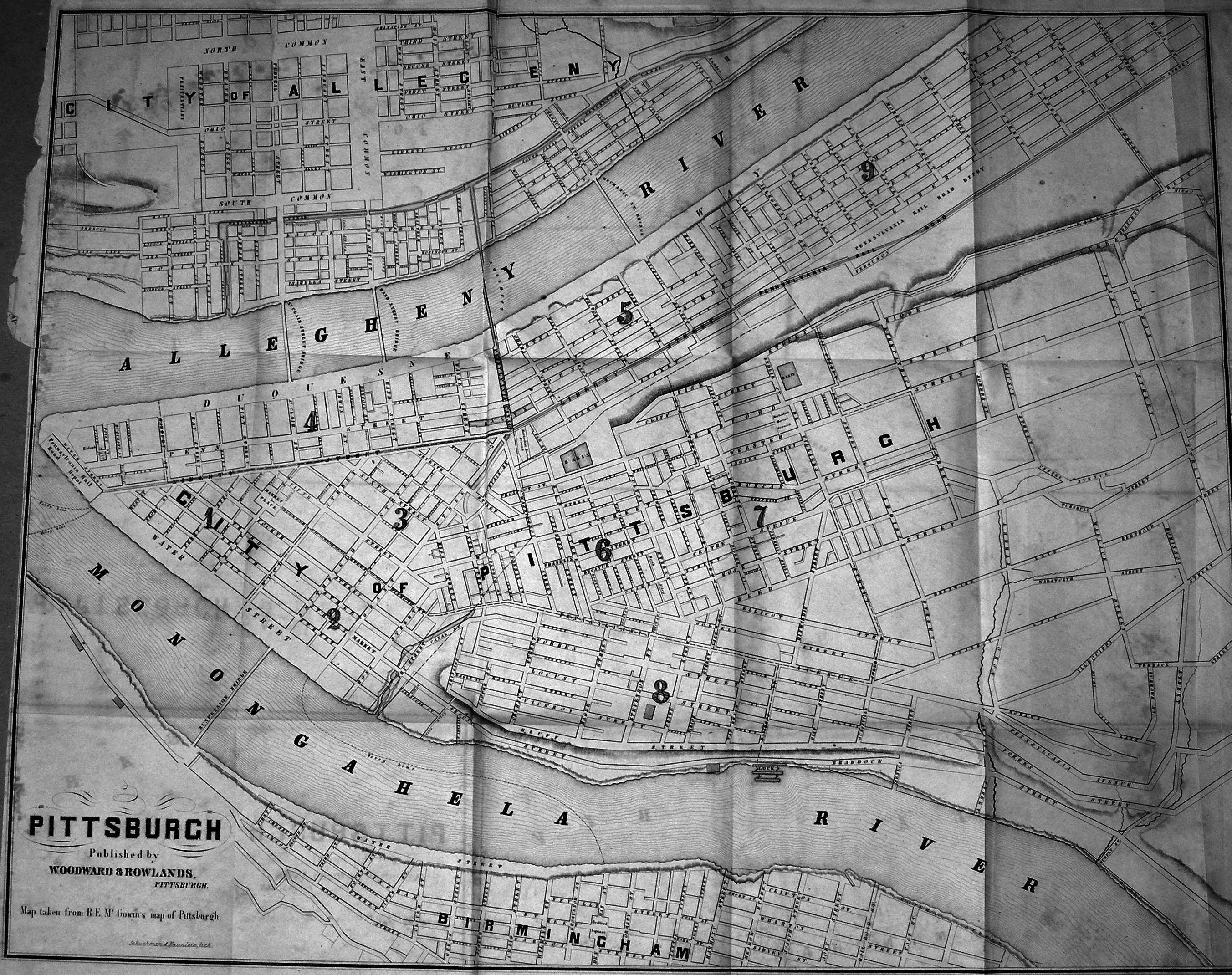
1828 map showing the Allegheny/Downtown canal system:


1853 map--still there:


Ditto 1855:


And 1860:


But 1872, it is gone (replaced by the railroad system)

Reply With Quote
     
     
  #5515  
Old Posted Oct 5, 2013, 3:55 PM
GeneW GeneW is offline
Northsider
 
Join Date: May 2007
Posts: 657
This has probably been posted here before (maybe by me) but this site from ESRI lets you switch back and forth between historical maps of Pittsburgh and the current map.
Reply With Quote
     
     
  #5516  
Old Posted Oct 5, 2013, 8:03 PM
Found5dollar Found5dollar is offline
Registered User
 
Join Date: Jun 2012
Posts: 196
Thanks for the info and maps, BrianTH, but the tunnel existed untill at least 1968 when the US steel buildign was under construction. (see the picture here http://pghbridges.com/pittsburghE/0585-4477/pacanal_tun.htm) it was likely not in use, but it still existed. This lead me to wonder was it filled in during the construction or left alone? Is it still usable for possibly a transit tunnel today? I would imaging it would need major stability studies if it still is there.
Reply With Quote
     
     
  #5517  
Old Posted Oct 5, 2013, 8:33 PM
Minivan Werner Minivan Werner is offline
Registered User
 
Join Date: Sep 2008
Posts: 498
Having a hard time picturing canals on the North Shore and behind Grant St. I'm also curious as to why they dropped a lot of the street names along the Allegheny side of town.. Wayne, Hand, Irwin, Hay, etc.
Reply With Quote
     
     
  #5518  
Old Posted Oct 5, 2013, 9:17 PM
BrianTH BrianTH is offline
Registered User
 
Join Date: Jan 2010
Posts: 6,078
Quote:
Originally Posted by Found5dollar View Post
Thanks for the info and maps, BrianTH, but the tunnel existed untill at least 1968 when the US steel buildign was under construction.
Right, I would assume it was just closed on the ends back in the 1860s.

Quote:
Is it still usable for possibly a transit tunnel today? I would imaging it would need major stability studies if it still is there.
Keep in mind we are talking about an 1820s, pre-railroad, tunnel. I have a hard time believing it could be opened and used even if it is still structurally sound.
Reply With Quote
     
     
  #5519  
Old Posted Oct 5, 2013, 11:39 PM
GeneW GeneW is offline
Northsider
 
Join Date: May 2007
Posts: 657
Quote:
Originally Posted by Minivan Werner View Post
Having a hard time picturing canals on the North Shore and behind Grant St. I'm also curious as to why they dropped a lot of the street names along the Allegheny side of town.. Wayne, Hand, Irwin, Hay, etc.
Not sure which specific names of those where changes when but I do know that a lot of names on the North Side were changed when the cities merged because of name conflicts. For instance Galveston on the North Side used to be called Grant which obviously had to be changed once Allegheny City became part of Pittsburgh.
Reply With Quote
     
     
  #5520  
Old Posted Oct 6, 2013, 12:35 AM
BrianTH BrianTH is offline
Registered User
 
Join Date: Jan 2010
Posts: 6,078
As an aside, the Water Steps and adjacent pool/square is an homage to the North Side canal system:

http://www.pgh-sea.com/northshoreriverfrontpark.htm#WaterSteps
Reply With Quote
     
     
This discussion thread continues

Use the page links to the lower-right to go to the next page for additional posts
 
 
Reply

Go Back   SkyscraperPage Forum > Global Projects & Construction > City Compilations
Forum Jump


Forum Jump


All times are GMT. The time now is 10:55 AM.


Powered by vBulletin® Version 3.8.7
Copyright ©2000 - 2026, vBulletin Solutions, Inc.