HomeDiagramsDatabaseMapsForum About
     

Go Back   SkyscraperPage Forum > Regional Sections > Canada > Alberta & British Columbia > Calgary > Transportation & Infrastructure


Closed Thread

 
Thread Tools Display Modes
     
     
  #4441  
Old Posted Jan 17, 2012, 5:10 PM
Full Mountain's Avatar
Full Mountain Full Mountain is offline
YIMBY
 
Join Date: Aug 2008
Posts: 2,938
Quote:
Originally Posted by YYCguys View Post
I'm placing this in this thread because I think that the Eamon Camp building should be dismantled and rebuilt and incorporated into the design of the new RR/Tuscany LRT station, if possible! I think it would be a great way to preserve important history of Calgary transportation and to maintain usefulness of the building!

Historic gas station faces uncertain future


By Richard Cuthbertson, Calgary Herald January 16, 2012

CALGARY — In its heyday, the bright lights could be seen for 20 kilometres. And though its glory years have long past, Eamon’s Bungalow Camp remains a landmark on Crowchild Trail.

But now one of Calgary’s last historic service stations faces an uncertain future as the city is buying the land to build a park-and-ride lot for the future LRT station serving Rocky Ridge, Royal Oak and Tuscany.

While the city does have plans to save, restore and reinstall the iconic Eamon’s Camp sign, heritage advocates fear the adjacent mid-century building will be demolished.


Read more: http://www.calgaryherald.com/Historic+st...+future/6000002/story.html#ixzz1jjRc1i6i
They should put a store/resturant in there, add a little income for CT
     
     
  #4442  
Old Posted Jan 17, 2012, 7:48 PM
DizzyEdge's Avatar
DizzyEdge DizzyEdge is offline
My Spoon Is Too Big
 
Join Date: Oct 2006
Location: Calgary
Posts: 9,162
Quote:
Originally Posted by Bassic Lab View Post
The #3 would see a massive reduction in loads either way, we don't exactly have major bus routes mirroring other C-Train lines, but I really don't see why we would want huge distances between stations. If we followed the Canada Line example we would be aiming at 800 meter stop spacing, possibly with some stations not included in the initial project (like the proposed Canada Line stations at 33 Avenue and 57 Avenue). That kind of spacing would place the entire Centre Street corridor within walking distance of a station. There might still be a need for a more local service along Centre Street, for the elderly and disabled, but the odd community shuttle could handle that. There definitely wouldn't need to be a mainline route on Centre with sub five minute frequencies.

It would also make sense to consider the #2 and #3 together, eliminate extraneous segments, and combine what's left. The W LRT makes the Southwestern segment of the #2 relatively redundant, while a Centre Street Subway would make the northern section of the #3 pretty redundant. We'd end up with a single major route mostly taking Elbow Drive and 4 St NW with a detour over to Centre just to cross the river.

I think the idea of a Nose Creek alignment for the NC LRT combined with a Centre Street streetcar would be pointless. It would probably cost the same, if not more, than simply building the NC LRT under Centre Street and operational costs would be far higher.
Is this accurate? Perhaps the operating costs, but the initial costs of cut and cover underground LRT under Centre would be many times more expensive than laying down some track and catenary for a streetcar would it not?
__________________
Concerned about protecting Calgary's built heritage?
www.CalgaryHeritage.org
News - Heritage Watch - Forums
     
     
  #4443  
Old Posted Jan 17, 2012, 8:05 PM
suburb suburb is offline
BANNED
 
Join Date: Jun 2010
Posts: 945
Has there been any update on the gondola to foothills hospital?
     
     
  #4444  
Old Posted Jan 17, 2012, 10:09 PM
Radley77's Avatar
Radley77 Radley77 is offline
The City That Moves
 
Join Date: Sep 2008
Location: Bridgeland, Calgary
Posts: 1,450
Kinda weird proposal but thought I might ask it....

What about a developing a single lane of right of way on Edmonton Trail northbound, and a single lane of right of way on Centre Street southbound. Essentially any time a rapid bus comes to an intersection it would have precedence over any other timing signals and have it's own lane. Centre St and Edmonton trail blocks are about 3-4 blocks apart on average. Rapid buses would only stop at designated stops and no other vehichle would have priority over the rapid buses ensuring a quick travel time. Any bigger gap than 4 blocks could link a paired Edmonton Trail\Centre St stop via bike share.
     
     
  #4445  
Old Posted Jan 17, 2012, 11:45 PM
Policy Wonk's Avatar
Policy Wonk Policy Wonk is offline
Inflatable Hippo
 
Join Date: Mar 2006
Location: Suburban Las Vegas
Posts: 4,015
Quote:
Originally Posted by fusili View Post
A couple of other points:

1. It was mentioned that interlining isn't a bad thing with the NE LRT. To put this is context, the NE LRT currently serves 150K people, with plans for growth of 50K more. The NC LRT would currently serve 150K people, with plans for 180K more (North Regional Context Study). This would make the NC LRT have a catchment of 330K and the NE LRT with 200K. That is 530K people being served by a single set of tracks from downtown to the zoo station. To me, that seems completely short sighted. The zoo interlocking would hit capacity almost the day the NC LRT opened. And then we would add another 230K people to both lines after this? The numbers make it obvious that the NC LRT needs a separate ROW through the downtown, and the SE LRT makes the most sense.
First of all it will be necessary to grade separate the 7th Ave track through downtown long before building the North Central LRT in any form becomes a priority. Second of all interlocking capacity for the purposes of five car LRV consists is not really an issue with any sort of modern Railway Signal & Traffic Control practices. Calgary Transit is already in the process of replacing their relay based interlocking systems with Siemens S7 hardware already having been installed along the South Line. New Jersey Transit created the equivalent of a third track on the High Line into Manhattan out of thin air by modernizing their interlocking practices.

Quote:
2. We discuss on here how densification along centre street is this horrible and would be fought tooth and nail. However, densification doesn't have to be 25 storey towers anywhere. I imagine Centre street would be rezoned much like 16th avenue is now: 8 storey buildings (approx) along the street, 4 storey buildings one block from the street and then townhouses for the balance of the area. Heck, with just 3 storey stacked townhouses, we could almost triple the population. While some may object to townhouses (and really those people object to anything anyway), I think most people are pretty ok with them.
What cranky people object to is multifamily housing in general, what you suggest will be more than sufficient to bring out the "save our community" demagogues.
__________________
Public Administration 101: Keep your mouth shut until obligated otherwise and don't get in public debates with housewives.
     
     
  #4446  
Old Posted Jan 17, 2012, 11:57 PM
DizzyEdge's Avatar
DizzyEdge DizzyEdge is offline
My Spoon Is Too Big
 
Join Date: Oct 2006
Location: Calgary
Posts: 9,162
Quote:
Originally Posted by Radley77 View Post
Kinda weird proposal but thought I might ask it....

What about a developing a single lane of right of way on Edmonton Trail northbound, and a single lane of right of way on Centre Street southbound. Essentially any time a rapid bus comes to an intersection it would have precedence over any other timing signals and have it's own lane. Centre St and Edmonton trail blocks are about 3-4 blocks apart on average. Rapid buses would only stop at designated stops and no other vehichle would have priority over the rapid buses ensuring a quick travel time. Any bigger gap than 4 blocks could link a paired Edmonton Trail\Centre St stop via bike share.

Edit: actually, once Edm Trail reaches McKnight, it continues as 4th st NE. If you continued on across Thornecliff park, but then deviated East and ran along the West edge of the park space, parallel to Blackburn Rd, (or not, it's only 5 blocks on an otherwise non-thrufare stretch due to transit only access at the south end, so not having a dedicated lane for 5 blocks might be inconsequential) and then run right up to Beddington
__________________
Concerned about protecting Calgary's built heritage?
www.CalgaryHeritage.org
News - Heritage Watch - Forums

Last edited by DizzyEdge; Jan 18, 2012 at 12:09 AM.
     
     
  #4447  
Old Posted Jan 18, 2012, 12:34 AM
Bassic Lab Bassic Lab is offline
Registered User
 
Join Date: Oct 2005
Location: Calgary
Posts: 1,934
Quote:
Originally Posted by DizzyEdge View Post
Is this accurate? Perhaps the operating costs, but the initial costs of cut and cover underground LRT under Centre would be many times more expensive than laying down some track and catenary for a streetcar would it not?
That might have been off base since I didn't put that much thought into it before I typed. Still, I suppose it would depend a great deal on cost of the Nose Creek alignment but, as you suggested, I imagine the cost of a streetcar near Centre Street would involve a great deal more than simply laying track and stringing catenary. You mentioned vehicle barriers every four or five blocks, street work like that would begin to add up but there are many other costs. I imagine that far more intersections would need to be signalized. A new ROW downtown would be required. Rolling stock would need to be purchased, probably an absolute minimum of eight consists to achieve reasonable headways with some spares. A maintenance and storage facility would need to be built somewhere along the ROW which pretty well means expropriating a block of houses because the entire area is built up. Along with various other expenses.

I would expect such a project to cost well over half a billion dollars and provide little in the way of a tangible improvement over what busses are capable of in terms of service, capacity, or operational costs.

In comparison, I would expect the cost of tunnel, track, and stations between Eau Claire and Beddington Trail (~9km) to cost 1.5 billion. I'm not entirely sure what the final cost of track and stations would be for Nose Creek between Zoo Station and the Harvest Hills ROW (~12-14km) but it would depend massively on CPR (simply using their ROW under road bridges would probably chip nine figures off the construction cost). I suppose it could come in at about 500 million if CPR felt like leasing its ROW to us for little or nothing. I have significant doubts about their willingness to do so but that might just be me. All other costs, like rolling stock and storage/maintenance facilities (roughly the same number of trains and similar sized expansions of Oliver Bowen or the SE LRT's facility), would essentially be a wash. So yeah, I guess the combination could be half a billion cheaper. On the other hand, CPR could become intransigent or the province could try to lay their hands on the ROW for HSR/commuter rail to Airdrie (here isn't the place to argue the merits of either but I disagree with Policy Wonk; good idea or bad, there is a distinct possibility that the province would at least attempt to secure the ROW before the city constructs the NC LRT) which would make costs balloon.
     
     
  #4448  
Old Posted Jan 18, 2012, 1:05 AM
Policy Wonk's Avatar
Policy Wonk Policy Wonk is offline
Inflatable Hippo
 
Join Date: Mar 2006
Location: Suburban Las Vegas
Posts: 4,015
In 2008 three possible Nose Creek alignments outside of the CPR ROW were identified when for a time it seem the province was actually serious about HSR.

Supposedly there was also a discussion with the province about the possibility of swapping land in the Deerfoot Trail ROW for city owned land immediately east of the CPR ROW that might be used for HSR and then run the C-Train along Deerfoot.

There were actually four proposals, but one was pretty silly and would have trenched or tunnelled through Tom Campbell Hill and failed to serve the new Science Centre entirely. I vaguely recall another but nothing about it stuck with me.
__________________
Public Administration 101: Keep your mouth shut until obligated otherwise and don't get in public debates with housewives.
     
     
  #4449  
Old Posted Jan 18, 2012, 1:13 AM
Bassic Lab Bassic Lab is offline
Registered User
 
Join Date: Oct 2005
Location: Calgary
Posts: 1,934
Quote:
Originally Posted by Radley77 View Post
Kinda weird proposal but thought I might ask it....

What about a developing a single lane of right of way on Edmonton Trail northbound, and a single lane of right of way on Centre Street southbound. Essentially any time a rapid bus comes to an intersection it would have precedence over any other timing signals and have it's own lane. Centre St and Edmonton trail blocks are about 3-4 blocks apart on average. Rapid buses would only stop at designated stops and no other vehichle would have priority over the rapid buses ensuring a quick travel time. Any bigger gap than 4 blocks could link a paired Edmonton Trail\Centre St stop via bike share.
The tidal lane reversal with bus/HOV lane on Centre Street essentially already achieves this. According to this report http://www.mrc.ca/pdf/CUTA%20HOV%20Final%20Report.pdf , peak hour/peak direction use of Centre Street involves:

55 buses, 2750 passengers in HOV lane
330 carpools, 660 people in HOV lane
140 single occupant violators in HOV lane
1030 vehicles in remaining two peak direction GPLs

I'm not sure if "hour" means 1 hour, the report is from 2007 and I can't count an hour with 55 busses using the Centre Street Bridge today when the number should theoretically be higher (14 #3, 11 #301, 6 #2, 5 #109 Harvest Hills Express, 8 #116 Coventry Hills Express, 5 #142 Panorama Express, 2 #300, for 51 total busses) but then again I am probably missing some routes.

Now if the bus/HOV lane becomes congested we could relieve it in a number of ways. First we could get stricter enforcement from CPS to remove those 140 violators. Second we could move from a 2 occupant HOV standard to a 3 occupant standard, cutting down on the 330 legitimate cars in the lane. Finally, if congestion is still an issue, we could eliminate the HOV component of the lane entirely and make it a bus only lane (except for cars turning on the next block of course). Those options ought to ensure the kind of rapid bus service you're asking for if the current arrangement isn't good enough. The tidal flow-bus/HOV lane system can always be extended north and may indeed have to be to cope with increased bus loads that we can expect until the NC LRT is built (whether in Nose Creek or under Centre Street).

I don't think we would need a dedicated bus/HOV lane that travels counter to prevailing traffic conditions. I suppose a lot of busses still have to travel north in the AM peak (or south in the PM) so that they can again travel south but the reduced need to stop for boarding/disembarking passengers and the general lack of counter flow traffic probably combine to seriously reduce congestion, leading to a reasonably fast travel time. So yeah, it would probably be overkill.

     
     
  #4450  
Old Posted Jan 18, 2012, 1:27 AM
DizzyEdge's Avatar
DizzyEdge DizzyEdge is offline
My Spoon Is Too Big
 
Join Date: Oct 2006
Location: Calgary
Posts: 9,162
Quote:
Originally Posted by Bassic Lab View Post
That might have been off base since I didn't put that much thought into it before I typed. Still, I suppose it would depend a great deal on cost of the Nose Creek alignment but, as you suggested, I imagine the cost of a streetcar near Centre Street would involve a great deal more than simply laying track and stringing catenary. You mentioned vehicle barriers every four or five blocks, street work like that would begin to add up but there are many other costs. I imagine that far more intersections would need to be signalized. A new ROW downtown would be required. Rolling stock would need to be purchased, probably an absolute minimum of eight consists to achieve reasonable headways with some spares. A maintenance and storage facility would need to be built somewhere along the ROW which pretty well means expropriating a block of houses because the entire area is built up. Along with various other expenses.

I would expect such a project to cost well over half a billion dollars and provide little in the way of a tangible improvement over what busses are capable of in terms of service, capacity, or operational costs.

In comparison, I would expect the cost of tunnel, track, and stations between Eau Claire and Beddington Trail (~9km) to cost 1.5 billion. I'm not entirely sure what the final cost of track and stations would be for Nose Creek between Zoo Station and the Harvest Hills ROW (~12-14km) but it would depend massively on CPR (simply using their ROW under road bridges would probably chip nine figures off the construction cost). I suppose it could come in at about 500 million if CPR felt like leasing its ROW to us for little or nothing. I have significant doubts about their willingness to do so but that might just be me. All other costs, like rolling stock and storage/maintenance facilities (roughly the same number of trains and similar sized expansions of Oliver Bowen or the SE LRT's facility), would essentially be a wash. So yeah, I guess the combination could be half a billion cheaper. On the other hand, CPR could become intransigent or the province could try to lay their hands on the ROW for HSR/commuter rail to Airdrie (here isn't the place to argue the merits of either but I disagree with Policy Wonk; good idea or bad, there is a distinct possibility that the province would at least attempt to secure the ROW before the city constructs the NC LRT) which would make costs balloon.
Also, as I believe you touched on, you'd have to compare streetcar + Nose Creek alignment vs just under Centre.
__________________
Concerned about protecting Calgary's built heritage?
www.CalgaryHeritage.org
News - Heritage Watch - Forums
     
     
  #4451  
Old Posted Jan 18, 2012, 5:24 AM
Bassic Lab Bassic Lab is offline
Registered User
 
Join Date: Oct 2005
Location: Calgary
Posts: 1,934
Just to be complete I looked up the other routes that utilize the Centre Street Bridge to enter Downtown. I overlooked the #17 with 4 busses during an hour during the peak, the #62 with 6, and the #64 with ten (14 total during a period of an hour and twenty minutes during the peak, the other express routes have all of their busses pass by within an hour of each other). I think that is a complete list of all the busses which use the bridge. So I guess it is around 70 total busses per hour for peak travel, which means 55 for pre-2007 makes sense in sixty minutes. That is a hell of a lot of busses. 45 of them are limited stop express or BRT busses, 32 of which are purely peak hour/peak direction. So every 51.5 seconds during rush hour a bus uses the Centre Street Bridge to enter downtown in the AM peak or leave during the PM.

The "North Central Calgary Transit Corridor Review" (2006) (found here http://www.calgarytransit.com/pdf/north_central_calgary_transit_corridor_review.pdf ), which suggested a Nose Creek alignment and Policy Wonk and I discussed earlier, had some numbers of interest for this. In Table 6, it reported a total of 81 busses serving North Central Calgary for the AM peak hour/peak direction. 62 of those used Centre Street/4 Street (the other 19 used 10 Street West or Edmonton Trail). In Table 11, it reported that those 81 busses could potentially be increased to 120 (possibly more than doubling capacity from 4400 ppdph (this was prior to our acquisition of articulated busses) to 9600 if all mainline and BRT busses are replaced with articulated). I have no idea how many of those 39 new busses could be placed on Centre Street/4 Street and how many would go to 10 St W or Edmonton Tr. The report implied that those numbers would be about the maximum that our road network could handle.

Since the 2006 report, we have already used up a fair bit of that maximum potential capacity increase. We have added 8 busses to Centre Street's AM peak (4 more #301, the 2 #300 (which are, admittedly, still on a trial period), and the rest of the movement seems to be involve growth in express routes and a decline in mainline resulting in 2 additional busses) and we have begun to switch from regular busses to articulated. That growth seems faster than what the report expected, although it didn't give an explicit timeline for either population growth or ridership growth in the corridor. We may indeed require the NC LRT, no matter its routing, earlier than some of us expected.
     
     
  #4452  
Old Posted Jan 18, 2012, 12:07 PM
DizzyEdge's Avatar
DizzyEdge DizzyEdge is offline
My Spoon Is Too Big
 
Join Date: Oct 2006
Location: Calgary
Posts: 9,162
Quote:
Originally Posted by Radley77 View Post
Kinda weird proposal but thought I might ask it....

What about a developing a single lane of right of way on Edmonton Trail northbound, and a single lane of right of way on Centre Street southbound. Essentially any time a rapid bus comes to an intersection it would have precedence over any other timing signals and have it's own lane. Centre St and Edmonton trail blocks are about 3-4 blocks apart on average. Rapid buses would only stop at designated stops and no other vehichle would have priority over the rapid buses ensuring a quick travel time. Any bigger gap than 4 blocks could link a paired Edmonton Trail\Centre St stop via bike share.
So you were thinking something along the lines of:


Could be interesting, and would likely narrow the north central density intensification to the area between Centre and Edmonton Trail, rather than more just along Centre is it mostly seems headed now (north of 16th anyway).
__________________
Concerned about protecting Calgary's built heritage?
www.CalgaryHeritage.org
News - Heritage Watch - Forums
     
     
  #4453  
Old Posted Jan 18, 2012, 5:25 PM
Radley77's Avatar
Radley77 Radley77 is offline
The City That Moves
 
Join Date: Sep 2008
Location: Bridgeland, Calgary
Posts: 1,450
Quote:
Originally Posted by DizzyEdge View Post
So you were thinking something along the lines of:


Could be interesting, and would likely narrow the north central density intensification to the area between Centre and Edmonton Trail, rather than more just along Centre is it mostly seems headed now (north of 16th anyway).
Thanks for your insight DizzyEdge & Bassic Lab. Yeah, I was thinking how densification patterns might change from something that is more along the lines of a long linear high street versus something that feels more village-esque type of infill development. I would recommend that the loop does not cross paths at all with itself such that right of way can be maintained.

I think the challenge with the current rapid transit tidal pattern is that flow can occur well in one direction, but not the other direction. Under current configuration the capacity can be increased as per Bassic Lab's comments but the flow rate can not. Transit can not move faster than it currently is because there is conflicting transit right of ways which require acceleration and deceleration at intersections. Having two streets running in a parallel looping pattern would allow flow capacity & flow rate to be increased.

The other thing I was thinking about was how good bike infrastructure would be incredibly important where there is a bit of a gap between the two northbound and southbound routes.

Once this strategy for incremental growth was exhausted, then the City of Calgary would have no other choice for servicing demand growth but to put in a tunnel or elevated rail.

Thanks for your comment on this random idea.

Last edited by Radley77; Jan 18, 2012 at 5:49 PM.
     
     
  #4454  
Old Posted Jan 18, 2012, 8:08 PM
mersar's Avatar
mersar mersar is offline
Registered User
 
Join Date: May 2006
Location: Calgary, AB
Posts: 10,083
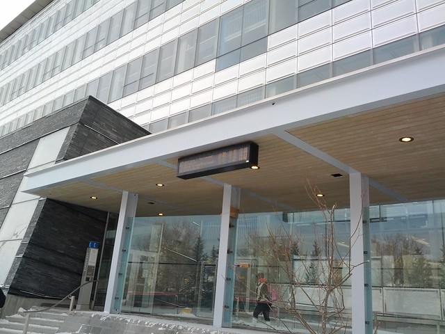
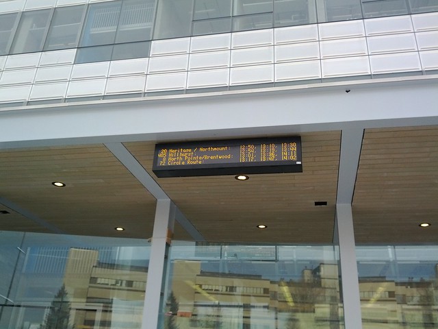
Someone at CPTDB noticed there is a sign similar to the real time signs at the CTrain stations mounted on the EEEL building at UofC, showing bus arrival times. So I went and grabbed some pictures and a short video of it:

• Video Link


Bus Arrival sign @ UofC by Jason R. Reid, on Flickr


Bus Arrival sign @ UofC by Jason R. Reid, on Flickr
__________________

Live or work in the Beltline? Check out the Official Beltline web site here
     
     
  #4455  
Old Posted Jan 18, 2012, 9:12 PM
freeweed's Avatar
freeweed freeweed is offline
Home of Hyperchange
 
Join Date: Sep 2006
Location: Dynamic City, Alberta
Posts: 17,568
I can't decide if I prefer actual times being displayed, or the "mins until" style the C-Train uses. This probably makes more sense when you're displaying several routes at once.
     
     
  #4456  
Old Posted Jan 18, 2012, 9:23 PM
DizzyEdge's Avatar
DizzyEdge DizzyEdge is offline
My Spoon Is Too Big
 
Join Date: Oct 2006
Location: Calgary
Posts: 9,162
In this instance a mix would be idea, Mins Until for the next bus, then times for the later ones
__________________
Concerned about protecting Calgary's built heritage?
www.CalgaryHeritage.org
News - Heritage Watch - Forums
     
     
  #4457  
Old Posted Jan 18, 2012, 9:59 PM
5seconds 5seconds is offline
Closed account
 
Join Date: Mar 2011
Posts: 935
I assume that is just an electronic schedule, rather than any kind of live data?

It's a good idea, but what I really want to know is if my bus is actually on time, or possibly more important, if my bus (the last one) has already come and gone, or if I should wait because it's late.
     
     
  #4458  
Old Posted Jan 18, 2012, 10:16 PM
TransitSupporter TransitSupporter is offline
Registered User
 
Join Date: Jan 2008
Location: Calgary
Posts: 52
Quote:
Originally Posted by 5seconds View Post
I assume that is just an electronic schedule, rather than any kind of live data?

It's a good idea, but what I really want to know is if my bus is actually on time, or possibly more important, if my bus (the last one) has already come and gone, or if I should wait because it's late.

I think you're right - i.e. just an electronic schedule. The times listed look too even and perfect to be eta's in my opinion. I presume it's just a pilot because the first line for Rte 20 shows Heritage / Northmount - which doesn't make sense - it should just say Northmount because the Heritage bus would stop across the street.
     
     
  #4459  
Old Posted Jan 18, 2012, 10:52 PM
frinkprof's Avatar
frinkprof frinkprof is offline
Registered User
 
Join Date: Sep 2006
Location: The Gary
Posts: 4,865
^Yeah it's an electronic schedule. I'd imagine the plan is to have it become populated with realtime arrival information as the bus fleet gets fully fitted with GPS/RFID equipment and the control segments of the system are capable of handling buses as well as the LRT system.

I think we'll start to see these signs also go up at the following locations:

Bus loops at LRT stations (perhaps starting with having one at the new bus shelter that will be built when Chinook closes down this year and is rebuilt)
MRU
Foothills Hospital
Rockyview Hospital
     
     
  #4460  
Old Posted Jan 19, 2012, 12:42 AM
sim sim is offline
Registered User
 
Join Date: Aug 2008
Posts: 863
Quote:
Originally Posted by Policy Wonk View Post
A discussion about the economic, engineering and environmental obstacles that influence mass transit decisions would be an interesting one. Do yourself a favor and don't look at the route of the Lynx Light Rail in Charlotte North Carolina. Its route is derived almost entirely from available remnants of Norfolk Southern right-of-ways. Why? Because the securing a more desirable right-of-way was too expensive.
Well I do appreciate the example, now there is at least some sort of support to the argument.

However, I am looking at this corridor and nowhere do I see any sort of similiarity with the amount of not built up area that the nose creek corridor would entail. There basically isn't any greenfield/park/non-use of land surrounding the tracks and stations in this case at all. Low density housing does seem to be around it though.

Anyway, regardless of that, the line seems to acheive about 15,000 passengers/day. Not exactly something worth striving for, as is the case for many an American example.

I think the point was made before, but such an alignment would deviate largely from the means that have created any sort of this success that CT is deemed to have.

If the NCLRT route up center is such a politically and economically hopelessly infeasible pill to swallow, then perhaps the best option truly is not to build one at all.
     
     
This discussion thread continues

Use the page links to the lower-right to go to the next page for additional posts
 
 
Closed Thread

Go Back   SkyscraperPage Forum > Regional Sections > Canada > Alberta & British Columbia > Calgary > Transportation & Infrastructure
Forum Jump


Forum Jump


All times are GMT. The time now is 6:27 AM.


Powered by vBulletin® Version 3.8.7
Copyright ©2000 - 2026, vBulletin Solutions, Inc.