HomeDiagramsDatabaseMapsForum About
     

Go Back   SkyscraperPage Forum > Regional Sections > Canada > Alberta & British Columbia > Vancouver > Transportation & Infrastructure


Closed Thread

 
Thread Tools Display Modes
     
     
  #2901  
Old Posted Jun 7, 2010, 11:15 PM
Kwik-E-Mart Kwik-E-Mart is offline
A.H.-Ha!
 
Join Date: Mar 2008
Location: Cambie Village, Van City
Posts: 348
Quote:
Originally Posted by BCPhil View Post
The only reason to build the terminus at Douglas College is so future extensions can be made into Burke Mountain. It's mostly undeveloped and can start off being very high density. I think the Foot Hills at Burke mountain is going to be a healthy mix of SFH, Townhomes and condos. Most of Burke Mountain can be that in the future if Skytrain extension into the area is possible. I can see demand warranting an extension from Douglas to David and Pipeline to serve as a community shuttle hub shortly after the line is built. And it doesn't need to be done mega project style, but like how Skytrain was gradually extended from Scott Road to King George. When it's all above ground you can easily build it one station every few years to spread out the cost.
The 35,000-40,000 population that is projected for the entire Burke Mountain area certainly does not support SkyTrain-style transit. That's even factoring for the smaller-lot single family residential and condos+townhomes that would put Westwood Plateau to shame. The introduction of frequent conventional bus service from Douglas Station to Downtown Poco via David, Coast Meridian, and Lougheed Hwy -- supported by a network of community shuttle routes -- is more than enough for Burke Mountain and Northside Poco (with a combined population of no more than 85,000*). The route is also mentioned in the 2040 Metro Regional Plan.

* As an aside, I didn't include Dominion Triangle/Freemont Village and the area within Coquitlam River, Oxford, Prairie, and Lougheed into the equation as they are within the 701 service area. Despite the proliferation of Costco and surrounding strip mall complexes, most of that area is CD-designated, which means the conversion to higher density developments should be fairly easy.

Last edited by Kwik-E-Mart; Jun 7, 2010 at 11:45 PM.
     
     
  #2902  
Old Posted Jun 7, 2010, 11:44 PM
nname nname is offline
Registered User
 
Join Date: Aug 2005
Posts: 5,106
Quote:
Originally Posted by Kwik-E-Mart View Post
The 35,000-40,000 population that is projected for the entire Burke Mountain area certainly does not support SkyTrain-style transit. That's even factoring for the smaller-lot single family residential and condos+townhomes that would put Westwood Plateau into shame. The introduction of frequent conventional bus service from Douglas Station to Downtown Poco via David, Coast Meridian, and Lougheed Hwy -- supported by a network of community shuttle routes -- is more than enough for Burke Mountain and Northside Poco (with a combined population of no more than 85,000). The route is also mentioned in the 2040 Metro Regional Plan.
I would say a new station at David, then

- A new frequent conventional route from possibly Port Moody North via David (Skytrain), Coast Meridian, Kingsway to Poco Centre and Poco Station
- A new community shuttle route from Coquitlam Station, via Johnson, David (Skytrain), then loop around Bruke Mountain
- Reroute C27 from Guildford to Glen
- Keep C28 at Pinetree
- Combine the C29 and C30 from Coquitlam Station via Pinetree, Glen, Pipeline, LaFarge Park, David (Skytrain), then up Johnson to Plateau Blvd
- Delete the Glen loop from C38: from Coquitlam Station via Pinetree, Lincoln, Westwood, ...

This way, David station can become the main transfer point for both Burke Mountain and Westwood Plateau, and the bus resources can be better used instead of running 8 different routes on Pinetree.

A picture worth a thousand word... Map

Last edited by nname; Jun 8, 2010 at 12:15 AM.
     
     
  #2903  
Old Posted Jun 8, 2010, 3:38 AM
Zassk Zassk is offline
Registered User
 
Join Date: Sep 2009
Posts: 2,303
^ That would make 4 stations in less than 2 km... way too much. Even with just Coquitlam-Lincoln-Douglas, they will be spaced far more closely than the stations on the tail lines in Surrey or Richmond, and the Evergreen tail doesn't even serve as many people as those tails. IMO two stations should be enough for Coquitlam for 20 years.
     
     
  #2904  
Old Posted Jun 8, 2010, 6:30 AM
nname nname is offline
Registered User
 
Join Date: Aug 2005
Posts: 5,106
Quote:
Originally Posted by Zassk View Post
^ That would make 4 stations in less than 2 km... way too much. Even with just Coquitlam-Lincoln-Douglas, they will be spaced far more closely than the stations on the tail lines in Surrey or Richmond, and the Evergreen tail doesn't even serve as many people as those tails. IMO two stations should be enough for Coquitlam for 20 years.
Actually, the spacing is 850m, 800m, 1050m. The distance from the proposed Coquitlam Station to David is actually pretty close to 3km.
     
     
  #2905  
Old Posted Jun 24, 2010, 4:49 PM
Zassk Zassk is offline
Registered User
 
Join Date: Sep 2009
Posts: 2,303
I don't know if anyone else noticed, but there's been an update on the Evergreen Line website. The project submitted its application for Environmental Assessment Certificate in June, and will hold a few public meetings on the subject in two weeks. There's a June Update newsletter that mainly discusses this:

http://www.evergreenline.gov.bc.ca/documents/ProjectUpdates/100623_ProjectUpdate.pdf
     
     
  #2906  
Old Posted Jun 24, 2010, 8:27 PM
officedweller officedweller is offline
Registered User
 
Join Date: Jul 2001
Location: Vancouver
Posts: 41,804
Thanks for the update.
     
     
  #2907  
Old Posted Jun 24, 2010, 10:28 PM
nname nname is offline
Registered User
 
Join Date: Aug 2005
Posts: 5,106
     
     
  #2908  
Old Posted Jun 24, 2010, 11:08 PM
deasine deasine is offline
Vancouver Moderator
 
Join Date: Mar 2007
Posts: 5,747
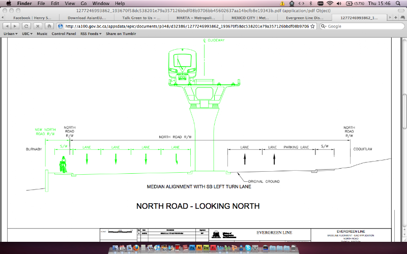
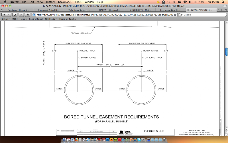
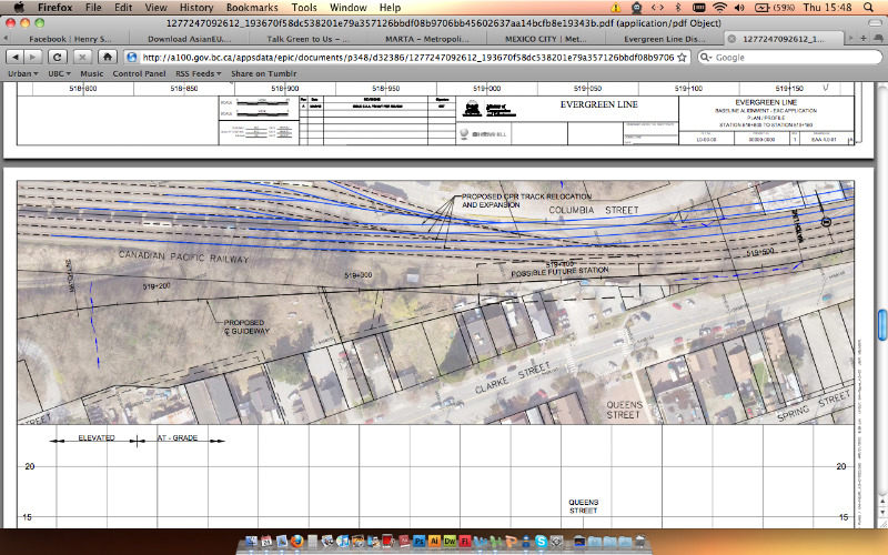
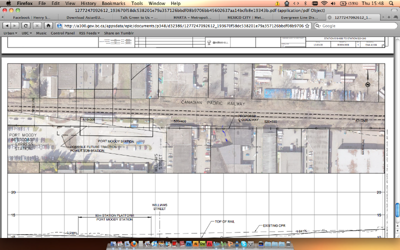
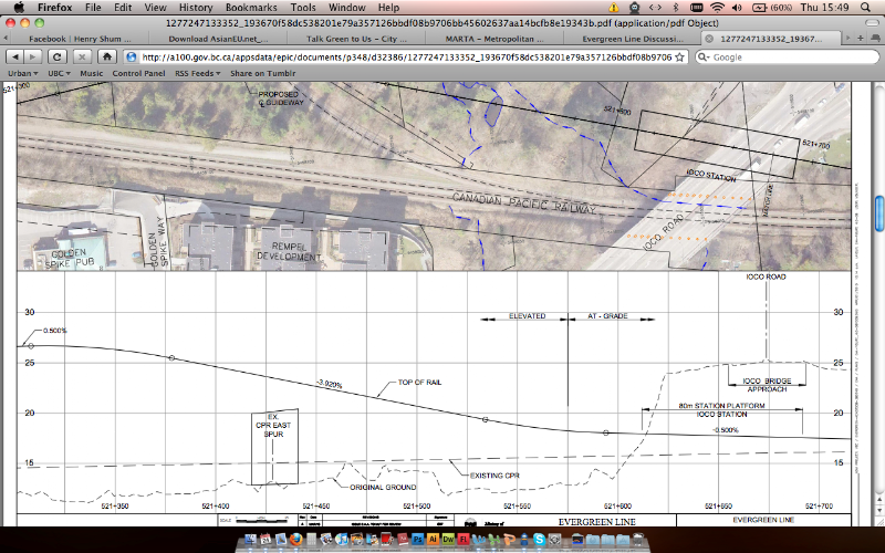
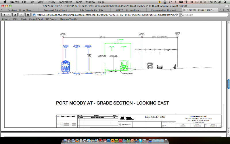
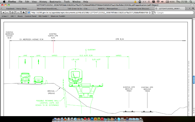
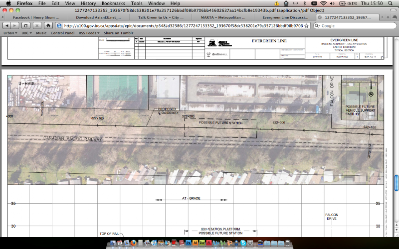
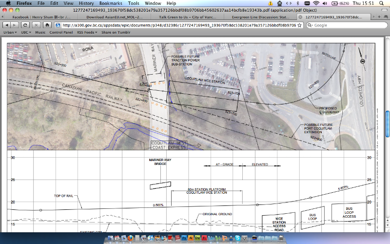
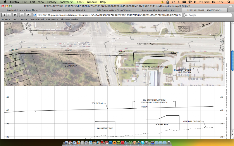
Not too much we don't know already, other than the precise exact alignment. The renderings we were show are quite accurate.


Notice
In the original LRT alignment, on the top right hand corner of this screenshot was to be the LRT OMC. In this case now, it is a future rail yard.


Notice
Future Coquitlam Spur Line


Notice
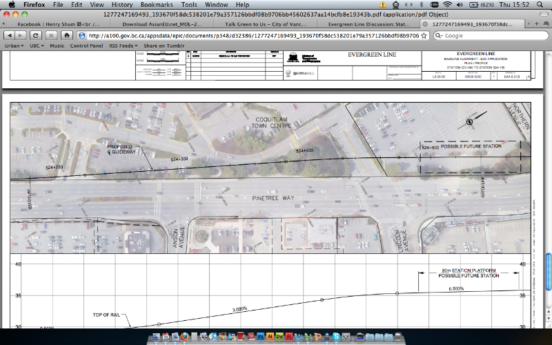
The guideway in Coquitlam is to be on the West side of the road rather than the centre, unlike what is proposed for Burnaby & Port Coquitlam on Clarke. Also, notice the location of Lincoln, still "proposed."


  #2909  
Old Posted Jun 24, 2010, 11:14 PM
tybuilding tybuilding is offline
Registered User
 
Join Date: Sep 2009
Posts: 898
I noticed that the Lincoln Ave station exists on Figure 3.5 of Volume 1 which is Coquitlam's neighbourhood plan.
     
     
  #2910  
Old Posted Jun 24, 2010, 11:49 PM
WarrenC12's Avatar
WarrenC12 WarrenC12 is online now
Registered User
 
Join Date: May 2007
Location: East OV!
Posts: 24,731
So one thing I see is a max of 6% gradient for various areas that require it. What is the current max on Skytrain, and where on the lines is it? I'm curious how this will compare.
     
     
  #2911  
Old Posted Jun 24, 2010, 11:53 PM
tybuilding tybuilding is offline
Registered User
 
Join Date: Sep 2009
Posts: 898
Quote:
Originally Posted by WarrenC12 View Post
So one thing I see is a max of 6% gradient for various areas that require it. What is the current max on Skytrain, and where on the lines is it? I'm curious how this will compare.
King George hill is 5 % but I think the steepest is coming out of Columbia. What it is I do not know.
     
     
  #2912  
Old Posted Jun 24, 2010, 11:55 PM
WarrenC12's Avatar
WarrenC12 WarrenC12 is online now
Registered User
 
Join Date: May 2007
Location: East OV!
Posts: 24,731
Quote:
Originally Posted by tybuilding View Post
King George hill is 5 % but I think the steepest is coming out of Columbia. What it is I do not know.
Interesting, so pretty much the same.

Great detail on these plans. Enough for SSP members to start shoveling.
     
     
  #2913  
Old Posted Jun 25, 2010, 2:00 AM
nname nname is offline
Registered User
 
Join Date: Aug 2005
Posts: 5,106
Quote:
Originally Posted by tybuilding View Post
King George hill is 5 % but I think the steepest is coming out of Columbia. What it is I do not know.
6% according to http://www.ottawa.ca/residents/public_consult/tmp/lrt/bombardier_en.pdf, page 15
     
     
  #2914  
Old Posted Jun 25, 2010, 5:40 AM
Metro-One's Avatar
Metro-One Metro-One is offline
Registered User
 
Join Date: Sep 2008
Location: Japan
Posts: 18,030
Nice to see all the station platforms displayed as 80 meters.

Also nice to see there will be provisions in place for a potential future station at Lincoln.

I hope Translink will be adamant in keeping the at grade section graffiti free. From riding the WCE the immediate surroundings of the CP rail line is among metro-Vancouver's worst vandalized areas. Lots of illegal dumping of garbage as well.
     
     
  #2915  
Old Posted Jun 25, 2010, 6:10 AM
Kwik-E-Mart Kwik-E-Mart is offline
A.H.-Ha!
 
Join Date: Mar 2008
Location: Cambie Village, Van City
Posts: 348
Good to see the layoff tracks not being on ground level with the terminus station located just north of Guildford Way instead of north of the Evergreen Cultural Centre parking lot.

However this brings the question on whether Lincoln will get built by 2014 given the close proximity to Douglas Station.
     
     
  #2916  
Old Posted Jun 25, 2010, 6:24 AM
aberdeen5698's Avatar
aberdeen5698 aberdeen5698 is offline
Registered User
 
Join Date: May 2010
Posts: 4,805
Quote:
Originally Posted by nname View Post
Actually page 35 of that PDF file says that the maximum grade is 10%.

Interesting about how much extra track they were able to avoid on the Columba-to-Skybridge segment by building it at a 6% grade.
     
     
  #2917  
Old Posted Jun 25, 2010, 7:28 AM
mr.x's Avatar
mr.x mr.x is offline
Registered User
 
Join Date: Dec 2003
Location: Stockholm
Posts: 12,805
Quote:
Originally Posted by Metro-One View Post
Nice to see all the station platforms displayed as 80 meters.
     
     
  #2918  
Old Posted Jun 25, 2010, 4:19 PM
Mininari Mininari is offline
Registered User
 
Join Date: Jul 2004
Location: Victoria (formerly Port Moody, then Winnipeg)
Posts: 2,447
Quote:
Originally Posted by WarrenC12 View Post
Interesting, so pretty much the same.

Great detail on these plans. Enough for SSP members to start shoveling.
Good, because we just might have to because last I checked, TransLink is still "broke and broken."

http://www.cbc.ca/canada/british-columbia/story/2010/06/25/bc-translink-no-expansion-report.html

Last edited by Mininari; Jun 25, 2010 at 4:35 PM.
     
     
  #2919  
Old Posted Jun 25, 2010, 5:16 PM
Zassk Zassk is offline
Registered User
 
Join Date: Sep 2009
Posts: 2,303
We're still waiting for the "pot of gold" Translink/Evergreen announcement from the Minister of Transportation that was supposed to be coming before the end of June.
     
     
  #2920  
Old Posted Jun 25, 2010, 5:30 PM
AlexYVR's Avatar
AlexYVR AlexYVR is offline
In Love With YVRthing
 
Join Date: Jan 2007
Location: Chicago:Vancouver
Posts: 441
Quote:
Originally Posted by Zassk View Post
We're still waiting for the "pot of gold" Translink/Evergreen announcement from the Minister of Transportation that was supposed to be coming before the end of June.
Here's the pot. It's empty.

No TransLink expansion says report
CBC News
Friday, June 25, 2010 | 9:22 AM PT

Read more: http://www.cbc.ca/canada/british-columbi...k-no-expansion-report.html#ixzz0rt3zhCaY


Quote:
Metro Vancouver's TransLink says there will likely be no further service expansions before 2013 because it's run out of money to add new services

Translink spokesperson Ken Hardie says the regional transit authority has enough money to sustain the previous five years' worth of expansion, but nothing more.

The news comes in a draft report that will be presented to Metro Vancouver's board on Friday morning. The report also suggests there could be another fare hike in 2013.

Despite the cash shortage, the transit authority is pursuing the expensive installation of fare-gates and smart cards, but Hardie said those are necessary improvements.

"Smart cards are going to be vitally important to us because we'll be able to tell who's using the system at what time for what length of trip — All of the data that we need to ensure that the various routes and the services and the schedules out there are as efficient and as effective as possible," said Hardie.

TransLink also launched as series of public consultations in April to get public imput on a new east-west rapid transit line intended to link UBC with the SkyTrain and Canada Line routes, but so far there appears to be no funding to build the route.

The regional transportation authority has also said it has no cash to build the much-delayed Evergreen rapid transit line linking Burnaby and the Tri-Cities area, east of Vancouver, despite promises from the provincial government that the line will get built.

Read more: http://www.cbc.ca/canada/british-columbi...k-no-expansion-report.html#ixzz0rt3hBAeh
Source: http://www.cbc.ca/canada/british-columbia/story/2010/06/25/bc-translink-no-expansion-report.html
     
     
This discussion thread continues

Use the page links to the lower-right to go to the next page for additional posts
 
 
Closed Thread

Go Back   SkyscraperPage Forum > Regional Sections > Canada > Alberta & British Columbia > Vancouver > Transportation & Infrastructure
Forum Jump


Forum Jump


All times are GMT. The time now is 5:43 PM.


Powered by vBulletin® Version 3.8.7
Copyright ©2000 - 2026, vBulletin Solutions, Inc.