HomeDiagramsDatabaseMapsForum About
     

Go Back   SkyscraperPage Forum > Regional Sections > Canada > Alberta & British Columbia > Vancouver > Transportation & Infrastructure


Closed Thread

 
Thread Tools Display Modes
     
     
  #3021  
Old Posted May 29, 2009, 3:01 AM
Gordon Gordon is offline
Registered User
 
Join Date: Jul 2008
Posts: 1,065
They do run some shuttle trains between Broadway and Waterfront AM peaks during the main UBC Sessions. The old short turn @ Metrotown may be something that that we'll see once the 2 vehicle orders 72 cars by end 2011) have been delivered on an as needed basis.

Would a plausible way of increasing the service levels In the tri cities be to feed more buses into Skytrain?
     
     
  #3022  
Old Posted May 29, 2009, 3:19 AM
deasine deasine is offline
Vancouver Moderator
 
Join Date: Mar 2007
Posts: 5,747
Quote:
Originally Posted by usog View Post
Here's a random thought I had today. How hard would it be to add an extra platform/track to Edmonds station on the side? If they did that then won't they be able to run the Waterfront<->Metrotown(or in this case Edmonds) shuttle runs that they wanted to? I doubt it would cost that much and the benefit would probably be enough to justifty it.
You don't need to build an extra platform to do that...

I see it more important to build a platform at Columbia but structurally, that would be challenging.

Edit:
Anyway... responding to an old comment made earlier about the signage at Waterfront Station: this is the kind of signs I want. Our signs aren't standardized enough... you can tell there are slight differences between Millennium Line & Expo Line (even the new ones). These signs I made are kind of quick doodles, but basically these signs should be used in all transit modes (other than bus stops of course).


My Photo

Some are a little small... but basically, you have these platform signs that are exactly like the Millennium Line ones except with added transit mode logos. Then, Station Information signs are just posted all over the platform on columns just so that commuters/tourists can have a snapshot of the overall area and decide which exit they want to take before leaving the platform... In SkyTrain stations (unlike MTR for instance), most of the exits are from the platforms... not from a large combined ticket concourse. So by the time you take one exit, it's too late before you realize you are supposed to take something else. On the map, it will state OUT (exits) that are relavant for your location. For instance, if you are on the SkyTrain platform at Waterfront, the Granville Mall exit at the Canada Line won't be a relevant exit, and thus, it won't be displayed. The map also displays streets, bus connections, and nearby attractions. Underneath the map, there are exits to which exits lead to what. Station Connections are also displayed below the map, if there are any that is.

The other sign I think they should add are train information signs at the platform. At many stations, yes they display where the train goes to, but not the exact terminus station but the city. If you are a tourist, you wouldn't be able to understand... so why not display the terminus so everyone knows where they are going. Also, I think a map should be placed to see where that train would be heading to... this is done in many systems including Hong Kong MTR, London DLR (which is what I based the sign on), etc. The map indicates stations it would be heading to, transfer points, as well as zones. On the Canada Line (I know it's like impossible to see, but "Zone Airport" is indicated, and it states that traveling within the Zone Airport is free.


Last edited by deasine; May 29, 2009 at 3:44 AM.
     
     
  #3023  
Old Posted May 29, 2009, 4:50 AM
fever's Avatar
fever fever is offline
Senior Member
 
Join Date: Nov 2001
Posts: 2,019
I think the train/seabus symbols on the main platform sign are a bit small. Do you think it's confusing that the main platform sign for the Canada line and Expo line take the colour of just one of the branches? Is there a way to incorporate both colours?

I don't like the WCE train symbol. It's too square. Maybe make the windows bigger?

You use Granville Mall instead of OUT: Granville on one of the Canada line signs, and a lot of the Expo line exit signs don't say OUT: <location>. That could be more consistent.
     
     
  #3024  
Old Posted May 29, 2009, 4:58 AM
deasine deasine is offline
Vancouver Moderator
 
Join Date: Mar 2007
Posts: 5,747
Quote:
Originally Posted by fever View Post
I think the train/seabus symbols on the main platform sign are a bit small. Do you think it's confusing that the main platform sign for the Canada line and Expo line take the colour of just one of the branches? Is there a way to incorporate both colours?

I don't like the WCE train symbol. It's too square. Maybe make the windows bigger?

You use Granville Mall instead of OUT: Granville on one of the Canada line signs, and a lot of the Expo line exit signs don't say OUT: <location>. That could be more consistent.
The WCE train symbol is straight from the one posted in paradigm's photos... so I kinda drafted it out XD I'll refine it when I have time.

I was thinking about the colour for main platform signs but I think taking it from the colour of one of the branches is fine. The main line of the two lines should have the colour. Another method is to have a line going through the bottom for the other colour... which might work. The symbols can definitely be larger.

Technically, I don't like any of the direction signs I drew... but they are sort of similar to the TransLink ones.

Many of stations don't specify the exit name and so I think it is important to have the location. TransLink should replace all the signs at stations (or add new ones depending) and there should be a consistent template. I wish we could just have London's branding scheme =S
     
     
  #3025  
Old Posted May 29, 2009, 9:28 AM
ravman ravman is offline
BANNED
 
Join Date: Mar 2008
Posts: 560
Quote:
Originally Posted by officedweller View Post
someone has ripped/peeled/ (whatever you call this thingy) a hole as of couple days ago
     
     
  #3026  
Old Posted May 29, 2009, 9:41 PM
deasine deasine is offline
Vancouver Moderator
 
Join Date: Mar 2007
Posts: 5,747
Quote:
Originally Posted by ravman View Post
someone has ripped/peeled/ (whatever you call this thingy) a hole as of couple days ago
This is what I mean by cheap. Anyways...

Quote:
399 King George B-Line
- The 399 “B-Line” will introduce a limited stop, express service with articulated buses along King George. The route begins in Guildford at 104 and 152, travels west along 104th, connects to Surrey Central and King George SkyTrain stations, travels south along King George Highway, connecting to Newton Exchange and the South Surrey Park and Ride, before turning south onto 152 St and ending at the Semiamoo Shopping Centre.
- Headways between Guildford and Newton were initially planned to be every 7.5 minutes - morning, noon, and night! Every second B-Line would go to White Rock, meaning headways of every 15 mins.
- Guildford to Surrey Central will take about 15 minutes. Surrey Central to Newton will take about 15 minutes. Newton to White Rock will take about 20 minutes.
- Local service would be reduced along the 320 Fleetwood and 321 Newton & White Rock. It would also eliminate the 394 peak hour route between White Rock and King George SkyTrain.
- The 399 is planned to begin service on March 1, 2010. This is of course subject to change, but the plan is to begin once the Olympics have wrapped.
- The 399 is an introductory service. It’s not a full BRT route. It will feature articulated buses, along with some possible queue jumpers and transit priority signals. It will not include “bus stations”, any new street furniture, nor will there be dedicated lanes or a busway.
- The 399 is being introduced several years earlier than initially planned due to the fact that it’s not a BRT. Furthermore, most of the route already has enough space to accomodate articulated buses (such as a dedicated area when a bus pulls over to drop off/pick up). Only Newton Exchange would require some slight modification to accomodate artics.
- The 399 is a working name. It was compared to the 145 which is noted on SkyTrain maps as a “B-Line like” rapid transit route, despite the fact that it’s not actually a B-Line. B-Line desgination is up to TransLink, not CMBC, and there is currently no strategy underway to consolidate the B-Line brand. It was also noted that the BRT type features, such as “bus stations” are quite expensive to install along roadways - money that just isn’t available.
- The 399 will use the buses from the 98 B-Line (Vancouver to Richmond), which will be discontinued once the Canada Line opens in September. The buses will be retrofit with primarily mechnical tune ups, but may include some interior adjustments. The buses will be back on the road for the Olympics, then come to Surrey.
Source: Paul Hillsdon
     
     
  #3027  
Old Posted May 29, 2009, 10:00 PM
hollywoodnorth's Avatar
hollywoodnorth hollywoodnorth is offline
Registered User
 
Join Date: Oct 2001
Location: Downtown Vancouver
Posts: 6,394
what about the HASTINGS B-LINE?

That is WAY more important than a Surrey Bline IMO.
__________________
Quote of the Decade on SSP: "what happens would it be?" - argon007

"orange vested guy" - towerguy3
     
     
  #3028  
Old Posted May 29, 2009, 11:20 PM
twoNeurons twoNeurons is offline
loafing in lotusland
 
Join Date: Aug 2002
Location: Lotusland
Posts: 6,122
Quote:
Originally Posted by hollywoodnorth View Post
what about the HASTINGS B-LINE?

That is WAY more important than a Surrey Bline IMO.
Politically, Surrey is FAR more important. You can't give Vancouver another B-Line, when the only major municipality that hasn't got one (or has rapid transit) is Surrey.
  • Burnaby had the 99 B-Line (during M-Line construction) and has lots of SkyTrain anyhow.
  • Richmond will have had the 98 B-Line
  • The Tri-Cities has the 97 B-Line
  • New West has excellent SkyTrain connections.

IN addition, Hastings does have some express buses there and there's no reason both can't be done.

The "#399" will be essentially the same as the SFU Express from Downtown until it's actually branded as a B-Line.
     
     
  #3029  
Old Posted May 30, 2009, 1:19 AM
Lover Fighter's Avatar
Lover Fighter Lover Fighter is offline
Registered User
 
Join Date: Apr 2004
Location: Van
Posts: 599
Sorry, if this has already been discussed in this thread as I don't follow it regularily, but have there been maps released detailing how Richmond busses will connect with the Canada Line? On the translink website it just points me in the direction of public consultation without any info.
Thanks.
     
     
  #3030  
Old Posted May 30, 2009, 2:18 AM
Gordon Gordon is offline
Registered User
 
Join Date: Jul 2008
Posts: 1,065
Has Translink said whether the frequencies of the #43 Joyce Stn . \UBC will be increased once the Canada Line opens because the April Timetable has only 10- 12 minute headways and that's no more than some of the trolley routes. 6-8 min frequencies might draw some riders away from the overburdened #99 B line.
     
     
  #3031  
Old Posted May 30, 2009, 2:28 AM
jlousa's Avatar
jlousa jlousa is offline
Ferris Wheel Hater
 
Join Date: Jun 2006
Posts: 8,371
Regarding the Hasting Bus lanes, they are coming very quickly

Quote:
BACKGROUND
On June 29, 2005 Council approved the installation of transit priority measures beginning with the Broadway corridor and expanding to four additional corridors including Main Street, Hastings Street, Burrard Street and 41st Avenue subject to funding and cost sharing approval.
The Hastings corridor is served by several high volume bus routes, including the #135, which connects Simon Fraser and Downtown Vancouver. As the #135 express bus service is replaced by the 95 B-Line service, the proposed transit priority measure will support the service and operation requirements of the 95 B-Line.
On May 5, 2009 Council received the Quick Start Recommendations from the Greenest City Action Team (GCAT). GCAT recommendation #29 is that the City should advocate for immediate investments and improvements in public transit. The recommendation contained in this report will help to achieve that.
DISCUSSION
Bus lanes are proposed on Hastings Street in the westbound direction from Boundary Road to Carrall Street during the AM peak hours and eastbound from Seymour Street to Boundary Road during the PM peak hours. The bus lanes would be implemented along the curb lane where parking is, at these times, currently restricted. There will be no changes to existing on-street parking. The installation of bus lanes in 2009 will simplify the creation of Olympic Lanes along the Hastings corridor in support of the 2010 Winter Olympics.
Benefits of Bus Lanes
TransLink states that, in principle, keeping the through traffic out of the curb lane will benefit transit by helping to maintain travel times and schedule reliability, and by promoting the status of transit. Although the travel time data measured from implementing the Broadway bus lanes showed little or no change to travel time, bus drivers were very supportive of the bus lanes. Staff are currently working with Translink and Burnaby staff to study Hastings Street for additional transit priority measures as part of the proposed 95 B-Line. The review is expected to be complete later this year and staff will report the details to Council once complete.
Public Response to the Hastings Bus Lanes
In April 2009, over 1,700 letters describing the proposed bus lanes were delivered to residents and businesses along the Hastings Corridor (Appendix B). Staff received fewer than 20 calls, most of which were seeking clarification. Also, staff spoke with the Hastings Business Improvement Association (BIA) and they did not have concerns with the proposed bus lane.
Bus Lanes on Hastings Street.
FINANCIAL IMPLICATIONS
The construction cost of the bus lanes was estimated to be $150,000. TransLink will fund the entire cost of the project.
CONCLUSION
It is recommended that the construction of bus lanes on Hastings Street from Boundary Road to Carrall Street proceed as shown in Appendix A.
Source
http://vancouver.ca/ctyclerk/cclerk/20090602/documents/ttra6.pdf
     
     
  #3032  
Old Posted May 30, 2009, 9:16 PM
Jared's Avatar
Jared Jared is offline
senior something
 
Join Date: Oct 2001
Location: Vancouver, Canada
Posts: 4,051
The main issue with the Broadway ones not being terribly useful seems to be that there is just so many right turners that the lanes are effectively clogged anyways. High pedestrian traffic along some parts of Broadway means that it takes a long time for cars to turn right, so the buses can get stuck there for quite a while, unless they pull into the middle lane. If Hastings has less right turning and less pedestrian traffic affecting the right turns, the bus lanes may work better.
__________________
My Diagrams My Photos

I'm not the guy from Subway.
     
     
  #3033  
Old Posted May 30, 2009, 10:07 PM
racc racc is offline
BANNED
 
Join Date: Oct 2008
Posts: 1,241
Quote:
Originally Posted by Jared View Post
The main issue with the Broadway ones not being terribly useful seems to be that there is just so many right turners that the lanes are effectively clogged anyways. High pedestrian traffic along some parts of Broadway means that it takes a long time for cars to turn right, so the buses can get stuck there for quite a while, unless they pull into the middle lane. If Hastings has less right turning and less pedestrian traffic affecting the right turns, the bus lanes may work better.
In Paris, where there are bus lanes, cars have to turn right from their lane instead of merging into the bus lane. It works a lot better.
     
     
  #3034  
Old Posted May 30, 2009, 10:19 PM
lightrail lightrail is offline
Registered User
 
Join Date: Oct 2007
Posts: 809
Quote:
Originally Posted by racc View Post
In Paris, where there are bus lanes, cars have to turn right from their lane instead of merging into the bus lane. It works a lot better.
In France - the vehicle on the right has the right-of-way, which is why this works. In this case, the bus has the right-of-way over right turning cars because the bus is to the right of the car.
     
     
  #3035  
Old Posted May 30, 2009, 10:52 PM
racc racc is offline
BANNED
 
Join Date: Oct 2008
Posts: 1,241
Quote:
Originally Posted by lightrail View Post
In France - the vehicle on the right has the right-of-way, which is why this works. In this case, the bus has the right-of-way over right turning cars because the bus is to the right of the car.
The vehicle in a lane has right-of-way over a vehicle turning into the lane so this would work here as well.
     
     
  #3036  
Old Posted May 31, 2009, 3:47 PM
deasine deasine is offline
Vancouver Moderator
 
Join Date: Mar 2007
Posts: 5,747
Quote:
Originally Posted by racc View Post
The vehicle in a lane has right-of-way over a vehicle turning into the lane so this would work here as well.
I wouldn't try that... can't imagine how many crashes will happen.

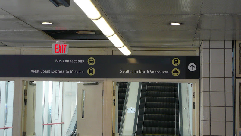
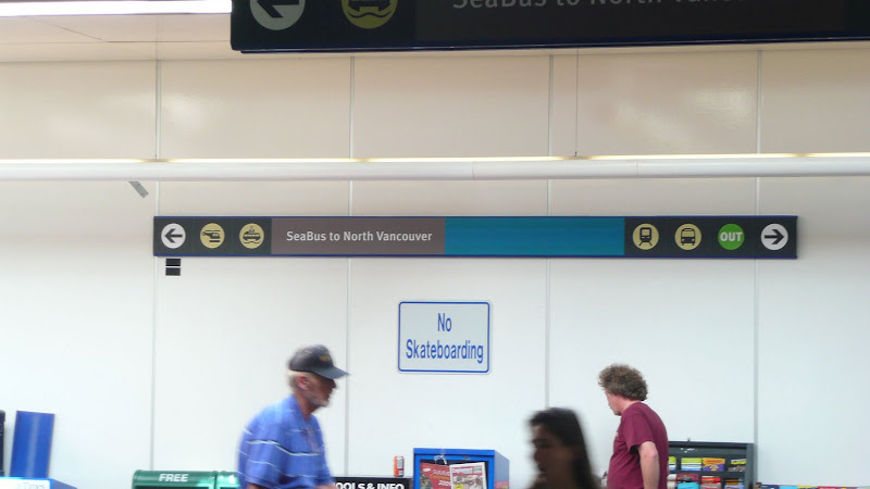
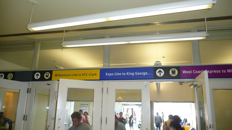
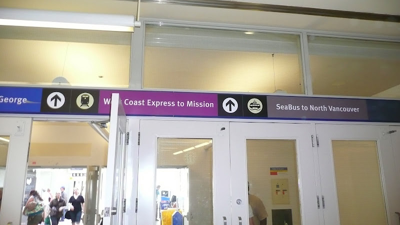
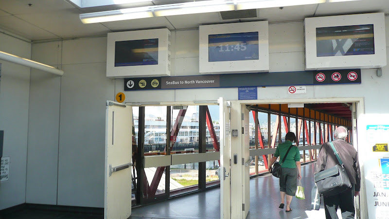
Anyways, more signs have been installed at Waterfront.


Taken by Deasine ∙ May 29 2009 ∙ Hosted on Picasa ∙ Creative Commons Protected


Taken by Deasine ∙ May 29 2009 ∙ Hosted on Picasa ∙ Creative Commons Protected


Taken by Deasine ∙ May 29 2009 ∙ Hosted on Picasa ∙ Creative Commons Protected


Taken by Deasine ∙ May 29 2009 ∙ Hosted on Picasa ∙ Creative Commons Protected


Taken by Deasine ∙ May 29 2009 ∙ Hosted on Picasa ∙ Creative Commons Protected


Taken by Deasine ∙ May 29 2009 ∙ Hosted on Picasa ∙ Creative Commons Protected

Notice the Canada Line signs are there... it's just taped. It also looks like the Canada Line would be branded as one... so much for having the red/blue lines =(
     
     
  #3037  
Old Posted May 31, 2009, 6:37 PM
deasine deasine is offline
Vancouver Moderator
 
Join Date: Mar 2007
Posts: 5,747
     
     
  #3038  
Old Posted May 31, 2009, 8:04 PM
Unregistered Unregistered is offline
Registered User
 
Join Date: Aug 2006
Posts: 78
And why light blue?
     
     
  #3039  
Old Posted May 31, 2009, 8:09 PM
mr.x's Avatar
mr.x mr.x is offline
Registered User
 
Join Date: Dec 2003
Location: Stockholm
Posts: 12,805
Rather dissapointing that Translink wasn't in charge of Canada Line branding.
     
     
  #3040  
Old Posted May 31, 2009, 9:01 PM
deasine deasine is offline
Vancouver Moderator
 
Join Date: Mar 2007
Posts: 5,747
Agreed.

@Usog: it's this aqua green... exactly the same colour used for the Canada Line signage. At least they got something right *rolls eyes*

I'm not sure if I want TransLink to be in charge of the Canada Line branding... they haven't been too successful at getting things done properly either.
     
     
This discussion thread continues

Use the page links to the lower-right to go to the next page for additional posts
 
 
Closed Thread

Go Back   SkyscraperPage Forum > Regional Sections > Canada > Alberta & British Columbia > Vancouver > Transportation & Infrastructure
Forum Jump


Forum Jump


All times are GMT. The time now is 1:20 PM.


Powered by vBulletin® Version 3.8.7
Copyright ©2000 - 2026, vBulletin Solutions, Inc.