HomeDiagramsDatabaseMapsForum About
     

Go Back   SkyscraperPage Forum > Photography Forums > Found City Photos


Reply

 
Thread Tools Display Modes
     
     
  #2061  
Old Posted Aug 8, 2026, 12:20 AM
Scott Charles's Avatar
Scott Charles Scott Charles is offline
Registered User
 
Join Date: Jan 2018
Location: Los Angeles
Posts: 693
Quote:
Originally Posted by Alkapone View Post
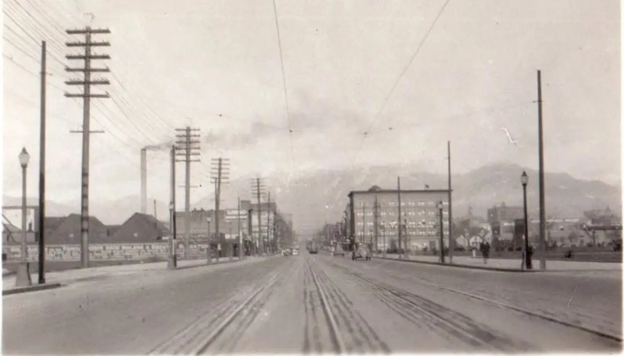
I’m digging up graves here from NLA v.1…..Here’s a shot on ebay (now relisted lower) that ER posted which could not be resolved: https://skyscraperpage.com/forum/showpost.php?p=10507101&postcount=63256

The alleged Los Angeles area street view….


old ebay listing linked above via NLA 1.

It’s a pretty low rez snap, but is there a chance in Hades that this could be a section of the old Broadway in Pasadena just down from Colorado well before the Arroyo Parkway project came along? Are the hills in similar formations? I’ve been puzzled for a while because this part of Pasadena is not very easy to explore.
Could the area be narrowed down by the telephone poles with the six horizontal bars? I haven't seen that type of pole all that often, but perhaps that's just me.

Perhaps the tall smokestack denotes an industrial area?

Whatever the case, that is a very wide street!
Reply With Quote
     
     
  #2062  
Old Posted Aug 8, 2026, 1:08 AM
HenryHuntington HenryHuntington is offline
Registered User
 
Join Date: Apr 2013
Location: The OC
Posts: 344
IIRC*, this scene eventually was traced to Salt Lake City.

* No warranty is expressed or implied.
Reply With Quote
     
     
  #2063  
Old Posted Aug 8, 2026, 1:13 AM
riichkay riichkay is offline
Registered User
 
Join Date: Jan 2016
Posts: 386
Quote:
Originally Posted by Alkapone View Post
Best I could get from trying to compare buildings in images, and that would be Loew’s State Theater on the NW corner, was to find those 3 diamond signs did exist in a triangular formation on the SE corner and the curved streetcar track was on the NW corner. Trying to match windows and awnings wasn’t working very well. Can’t quite make out that blade sign either. (It reads like GRAUMANS but that theater was up at the Edison Bldg. nearer 3rd.)

The sign you reference does indeed appear to read Graumans, and I think I see a marquee.....


...we also have a Kress 5-10-25 cents store....


....there was a Kress at 644-46 S Broadway, as seen in this 1936 photo from the UCLA Library...


So I think your initial guess of 7th and Broadway is correct.
Reply With Quote
     
     
  #2064  
Old Posted Aug 8, 2026, 10:46 AM
Alkapone Alkapone is offline
Registered User
 
Join Date: Nov 2016
Posts: 325
Quote:
Originally Posted by HenryHuntington View Post
IIRC*, this scene eventually was traced to Salt Lake City.

* No warranty is expressed or implied.
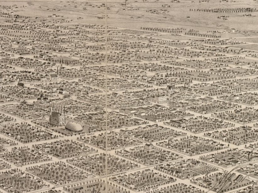
I had taken it to be a “greatly possible” suggestion rather than a conclusive decision. It did seem like we could be looking up Main or State, but from what I could find those hills to the north drop off abruptly on the west without any other hills left of that, while Pasadena does have those other features. To find poles with more than five crossarms in SLC I had to go back to a 1908 image on Main and there were as many as eight on some tall poles. Also, I could find lots of single smokestacks throughout SLC, but this one is a matched pair. (In Pasadena there was a pair at a powerhouse south of the city core, but that’s not anything conclusive.) As to an open space in SLC, we can go back to 1875 via LOC and find the 8th Ward Public Space down State (East 1st) shown here:
https://www.loc.gov/item/75696614/

Cropped section of 1875…


source LOC as linked.

I’m not sure if that sector survived into the 1920’s era to become what we see on the right of the photo. I only wish some details were clearer so something could be matched as a definite to give the location away. Colorado might even be hiding something, but I don’t think Pasadena is easily dismissed yet. They had a complex history of power generation and transmission which has gone beyond my abilities to be certain of anything yet. And while there are images on parts of Broadway, I don’t know if we have the full record of what was there and what was lost with all these improvement projects. And there were a lot of changes involving rail lines before earlier services were largely terminated with the Great Depression period. And whether SLC was far more developed by the ‘20’s than what we’re seeing in the photo is another problem. That town was on a roll back then.
Reply With Quote
     
     
  #2065  
Old Posted Aug 8, 2026, 2:45 PM
ethereal_reality's Avatar
ethereal_reality ethereal_reality is offline
Registered User
 
Join Date: Feb 2008
Location: Lafayette/West Lafayette IN, Purdue U.
Posts: 17,911
.

"Homes along the Pacific Coast Highway looking from the California Incline on February 14, 1970."


Photo by Leslie Storrs.


Do they mean the PCH incline or the lesser known funicular that used to be a mile or so north?


& are those cars parked in the middle of the highway?
.
Reply With Quote
     
     
  #2066  
Old Posted Aug 8, 2026, 2:47 PM
ethereal_reality's Avatar
ethereal_reality ethereal_reality is offline
Registered User
 
Join Date: Feb 2008
Location: Lafayette/West Lafayette IN, Purdue U.
Posts: 17,911
.

Just for fun here's the PCH Incline in 1934.


facebook


.
Reply With Quote
     
     
  #2067  
Old Posted Aug 8, 2026, 2:54 PM
ethereal_reality's Avatar
ethereal_reality ethereal_reality is offline
Registered User
 
Join Date: Feb 2008
Location: Lafayette/West Lafayette IN, Purdue U.
Posts: 17,911
.
Senior Trip to the La Brea Tar Pits.


Found on eBay


.
Reply With Quote
     
     
  #2068  
Old Posted Aug 8, 2026, 3:17 PM
ethereal_reality's Avatar
ethereal_reality ethereal_reality is offline
Registered User
 
Join Date: Feb 2008
Location: Lafayette/West Lafayette IN, Purdue U.
Posts: 17,911
.

I'm curious about the banner that has Sinatra's name on it. (I'm having difficulty reading the rest of it)


Described as:..."1940s Street Scene Taft Building Ticker Sign Hollywood Vine California"


.
Reply With Quote
     
     
  #2069  
Old Posted Aug 8, 2026, 4:01 PM
odinthor's Avatar
odinthor odinthor is offline
Registered User
 
Join Date: May 2015
Posts: 1,628


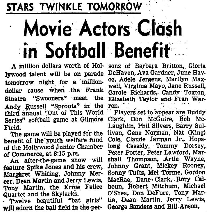
It talks about "Capt. Frank Sinatra" and "Capt. Andy Russell." It states August 23, so it's not the particular event in my clipping below, but is apparently rather a successor to that event.


LA Times, 7/31/1949

Play ball!
Reply With Quote
     
     
  #2070  
Old Posted Aug 8, 2026, 4:07 PM
ethereal_reality's Avatar
ethereal_reality ethereal_reality is offline
Registered User
 
Join Date: Feb 2008
Location: Lafayette/West Lafayette IN, Purdue U.
Posts: 17,911
.
Thanks, odinthor. ...I appreciate your help.


Mystery building.


Polaroid / eBay


.
Reply With Quote
     
     
  #2071  
Old Posted Aug 8, 2026, 4:55 PM
Noir_Noir Noir_Noir is offline
Registered User
 
Join Date: Feb 2018
Posts: 600
Quote:
Originally Posted by odinthor View Post


It talks about "Capt. Frank Sinatra" and "Capt. Andy Russell." It states August 23, so it's not the particular event in my clipping below, but is apparently rather a successor to that event.

It was the 1948 edition of The Swooners versus The Sprouts played on August 23rd.


cdnc.ucr.edu - Daily News (Los Angeles), 23 August 1948


A comprehensive report on the game, with lots of pictures, in the next day's LA Evening Citizen News is HERE and HERE .
Reply With Quote
     
     
  #2072  
Old Posted Aug 8, 2026, 5:59 PM
Martin Pal Martin Pal is offline
Registered User
 
Join Date: Sep 2013
Posts: 2,715
Quote:
Originally Posted by ethereal_reality View Post
.
Mystery building.


Polaroid / eBay


.
_______________________________________________________________
This is on the NW corner of Hollywood and La Brea. I recognized it because of the Christmas tree out front. "Mosaic" would have an unusual designed Christmas tree out front every year. One year it was all made out of wooden slats.


Yelp

The building at 7101 Hollywood Blvd. is now/was leased to a Christian church called Mosaic. It was the former Fifth Church of Christ Scientist, which was completed in 1959 and sold by church officials to the LeFrak Organization in 2008.

It seems Mosaic has lost their lease to the location in the fall of 2025 because of a developer and had to vacate. What's happening now is unclear. The structure is designated a cultural historical monument by the city.

But you know developers' stance on things like that: "Badges? We don't need no stinkin'badges."
Reply With Quote
     
     
  #2073  
Old Posted Aug 8, 2026, 6:32 PM
Alkapone Alkapone is offline
Registered User
 
Join Date: Nov 2016
Posts: 325
Quote:
Originally Posted by Martin Pal View Post
This is on the NW corner of Hollywood and La Brea. I recognized it because of the Christmas tree out front. "Mosaic" would have an unusual designed Christmas tree out front every year. One year it was all made out of wooden slats.


Yelp

The building at 7101 Hollywood Blvd. is now/was leased to a Christian church called Mosaic. It was the former Fifth Church of Christ Scientist, which was completed in 1959 and sold by church officials to the LeFrak Organization in 2008.

It seems Mosaic has lost their lease to the location in the fall of 2025 because of a developer and had to vacate. What's happening now is unclear. The structure is designated a cultural historical monument by the city.

But you know developers' stance on things like that: "Badges? We don't need no stinkin'badges."
Slightly right of this intersection was the improved cement irrigation ditch (or a flood control canal?) that John Bengtson was able to zero in on for Charlie Chaplin’s One A.M. mystery location…one of his readers finally spotted it. It might have been part of the very early Hollywood water system and maybe used for irrigation of those groves just south of Prospect, around the Bonnie Brier development to the east of La Brea. There was even a ditch remnant that ran down the land section that became Chaplin’s Studio, although it may then have been subducted or truncated as he built on the lot. I suspect this canal had something to do with water flows in the Outpost canyon area (west of the Highland corridor). It simply disappeared when a church was built on the property. Does anyone know more about that ditches’ history? Could it have just been filled in and still underlies the land over there?
Reply With Quote
     
     
  #2074  
Old Posted Aug 8, 2026, 6:47 PM
Alkapone Alkapone is offline
Registered User
 
Join Date: Nov 2016
Posts: 325
Quote:
Originally Posted by ethereal_reality View Post
.

"Homes along the Pacific Coast Highway looking from the California Incline on February 14, 1970."


Photo by Leslie Storrs.


Do they mean the PCH incline or the lesser known funicular that used to be a mile or so north?


& are those cars parked in the middle of the highway?
.
As an aside, coincidences being quite regular here, I was using the Calisphere link into the Santa Monica Public Library images which held about 225 pages of stuff. You can find another aerial taken from a low flying plane on the ocean side which captured that funicular/incline up there on the north end at what was once called Inspiration Point. The beach properties have arrived and the incline might already be just another abandonment by then. (The photo itself might be part of an entire sequence of survey images which have popped up individually in different institutional files. I just don’t know how many joyriding air photographers were out tweaking off shots of the Santa Monica bluffs in about 1920 or so.)
Reply With Quote
     
     
  #2075  
Old Posted Aug 8, 2026, 7:20 PM
Alkapone Alkapone is offline
Registered User
 
Join Date: Nov 2016
Posts: 325
Quote:
Originally Posted by ethereal_reality View Post
.

I'm curious about the banner that has Sinatra's name on it. (I'm having difficulty reading the rest of it)


Described as:..."1940s Street Scene Taft Building Ticker Sign Hollywood Vine California"


.

Notice how the roadway from this angle looks like it’s a messy jumble of laid in sections? The orginal Franklin Avenue loop line on the PE used to connect to Hollywood Boulevard at a switch here. That’s how they got the material down from Bronson Canyon quarries to build all the new roadways like the Sunset Boulevard extension into Sherman (now W. Hollywood). There were a couple of crossover tracks along Hollywood Blvd. and that curvature down at Highland which could access the trackage along Santa Monica Boulevard. All freight type traffic was confined to late night hours and there just weren’t any photographers capturing that activity. Ever notice how few images capture construction of all those buildings in Hollywood? And there were not a lot of big trucks to move in construction materials in the early years. Everything just seems to magically appear during daylight hours. At any rate, the Franklin loop was cut back to a terminus and they had to fill in these road sections in a piecemeal manor. Who can be sure of what underlies the city thoroughfares until they start the digging.

Last edited by Alkapone; Aug 8, 2026 at 7:22 PM. Reason: Fixin with “not”.
Reply With Quote
     
     
  #2076  
Old Posted Aug 8, 2026, 7:49 PM
Snix Snix is offline
Registered User
 
Join Date: Jun 2016
Posts: 222
Quote:
Originally Posted by westcork View Post
The opening sequence of Batman Returns was filmed there. They had Figueroa dressed up like Gotham City.
Warner Bros. was sued by the artist Andrew Leicester, who calls these towers "Zanja Madre," over using his artwork in "Batman Returns" without his permission. He lost the case.


https://www.herrick.com/publications/usi...ral-works-in-film-and-media-productions/
Reply With Quote
     
     
  #2077  
Old Posted Aug 8, 2026, 7:56 PM
Snix Snix is offline
Registered User
 
Join Date: Jun 2016
Posts: 222
Here it is before the makeover.

Fifth Church of Christ, Scientist (1959, Howard George Elwell)
Security Pacific National Bank Collection/Los Angeles Public Library
In 2014, developers tried to build this.

https://www.gmpaarchitects.com/project/horizon-hollywood/
In 2015 the church was declared City of Los Angeles Historic Cultural Monument #1097

Quote:
Originally Posted by Martin Pal View Post
This is on the NW corner of Hollywood and La Brea. I recognized it because of the Christmas tree out front. "Mosaic" would have an unusual designed Christmas tree out front every year. One year it was all made out of wooden slats.


Yelp

The building at 7101 Hollywood Blvd. is now/was leased to a Christian church called Mosaic. It was the former Fifth Church of Christ Scientist, which was completed in 1959 and sold by church officials to the LeFrak Organization in 2008.

It seems Mosaic has lost their lease to the location in the fall of 2025 because of a developer and had to vacate. What's happening now is unclear. The structure is designated a cultural historical monument by the city.

But you know developers' stance on things like that: "Badges? We don't need no stinkin'badges."
Reply With Quote
     
     
  #2078  
Old Posted Aug 8, 2026, 11:37 PM
riichkay riichkay is offline
Registered User
 
Join Date: Jan 2016
Posts: 386
We covered the church at Hollywood and La Brea back in NLA v1....

https://skyscraperpage.com/forum/showthr...light=Fifth+Church+of+Christ#post7741760
Reply With Quote
     
     
  #2079  
Old Posted Aug 9, 2026, 4:52 AM
Alkapone Alkapone is offline
Registered User
 
Join Date: Nov 2016
Posts: 325
Quote:
Originally Posted by riichkay View Post
The sign you reference does indeed appear to read Graumans, and I think I see a marquee.....


...we also have a Kress 5-10-25 cents store....


....there was a Kress at 644-46 S Broadway, as seen in this 1936 photo from the UCLA Library...


So I think your initial guess of 7th and Broadway is correct.
I put The State Theater on the NW corner which should have been SW. We can see the “BU” in Bullocks for that NW corner’s building.The Lankershim Building is where the Sun Drug is. Boos Brothers is still sitting where Clifton’s will later be found. The Orpheum is just north. And the Homestead blog has an earlier aerial that seems to have a Graumans blade sign on 6th but further west near Hill as you head over toward Pershing Square. Maybe it was shifted?

Last edited by Alkapone; Aug 9, 2026 at 4:59 AM. Reason: Adding Graumans info.
Reply With Quote
     
     
  #2080  
Old Posted Aug 9, 2026, 11:40 PM
riichkay riichkay is offline
Registered User
 
Join Date: Jan 2016
Posts: 386
Alkapone, let's go back to the original image.....


You are correct with the 7th and Broadway i.d., and the building on the left is Bullock's (at 639-57 S Broadway), as you have noted....here's a 1920's photo from Calisphere.....


Let's zoom....


We see the north end of Bullock's and the Kress store (although the address I had for Kress, 644-46 S Broadway, can't be correct as we are on the odd number side of the street)....and there's the Grauman's sign...


....detail....


So I think the only mystery remaining is to what building was the Graumans sign affixed?....I can't find any indication that Sid Grauman was involved in any theatre in the 600 block of S Broadway. 

Reply With Quote
     
     
This discussion thread continues

Use the page links to the lower-right to go to the next page for additional posts
 
 
Reply

Go Back   SkyscraperPage Forum > Photography Forums > Found City Photos
Forum Jump


Forum Jump


All times are GMT. The time now is 7:20 PM.


Powered by vBulletin® Version 3.8.7
Copyright ©2000 - 2026, vBulletin Solutions, Inc.