HomeDiagramsDatabaseMapsForum About
     

Go Back   SkyscraperPage Forum > Regional Sections > Canada > Manitoba & Saskatchewan


Reply

 
Thread Tools Display Modes
     
     
  #13181  
Old Posted Apr 30, 2026, 10:20 PM
Carboy15's Avatar
Carboy15 Carboy15 is offline
CanAutoroute1
 
Join Date: Oct 2022
Location: Centerville of Canada
Posts: 610
Reply With Quote
     
     
  #13182  
Old Posted May 1, 2026, 10:07 AM
FactaNV FactaNV is offline
Registered User
 
Join Date: Sep 2023
Posts: 2,381
Sure would be nice to have realiable intercity travel.
Reply With Quote
     
     
  #13183  
Old Posted May 1, 2026, 10:19 AM
WayneShuster WayneShuster is offline
Registered User
 
Join Date: Apr 2026
Posts: 133
Quote:
Originally Posted by Carboy15 View Post
Portage La Prairie will also be served apparently.
Reply With Quote
     
     
  #13184  
Old Posted May 12, 2026, 11:42 AM
Wpg_Guy's Avatar
Wpg_Guy Wpg_Guy is online now
Moderator
 
Join Date: Aug 2002
Location: Winnipeg, Manitoba
Posts: 8,611
Quote:
Province must resume role in transit funding
By: Editorial
Tuesday, May. 12, 2026
Opinion


MIKAELA MACKENZIE / FREE PRESS FILES

Public transit is an essential service for many people.


For a province that claims to be serious about fighting climate change, reducing traffic congestion and building more livable communities, Manitoba’s approach to public transit makes very little sense.

The provincial government has found room in its budgets for broad-based tax cuts on gasoline and groceries — measures that disproportionately benefit higher-income households — yet it continues to leave Winnipeg Transit largely on its own financially.

That needs to change.

The Kinew government should restore the 50/50 transit funding agreement with the City of Winnipeg, a long-standing arrangement scrapped by the former Progressive Conservative government in 2016.

Under that model, transit operating costs were shared equally between the province and the city.

Its cancellation was penny-wise and pound-foolish. A decade later, the consequences are showing up every day at bus stops across Winnipeg.

Transit service has deteriorated. Riders routinely deal with buses that don’t show up, overcrowded buses that pass them by and unreliable schedules that make getting to work, school or appointments unnecessarily stressful.

Even the city’s much-publicized new transit network, implemented last year, failed to solve the core problem because it reshuffled routes and eliminated hundreds of bus stops without adding the resources needed to improve service.

You can redesign routes all you want, but if there aren’t enough buses, drivers and operating dollars behind the system, riders will still be stranded.

That frustration was on full display Saturday at the Manitoba legislature, where more than 100 demonstrators gathered to call for better transit funding.

Organized by Climate Action Team Manitoba and the Amalgamated Transit Union, the rally featured a simple but powerful message: more buses, more routes and more reliable service.

Public transit is not a luxury service, it is essential infrastructure. For many Winnipeggers — particularly students, seniors, low-income residents and people with disabilities — public transit is their primary connection to jobs, education, health care and daily life. When buses are unreliable, those residents pay the highest price.

The province often talks about reducing greenhouse gas emissions. Transportation is one of the largest contributors to emissions in Manitoba. If government genuinely wants fewer cars on the road, it must provide people with a realistic alternative.

Reliable public transit reduces congestion, lowers emissions and cuts wear and tear on roads and infrastructure.

But the City of Winnipeg cannot shoulder the burden alone.

Winnipeg will spend roughly $128.6 million on transit operations in 2026, increasing to $133.8 million in 2027, excluding fare revenue. Provincial operating support, meanwhile, has remained flat at about $42 million since 2017. Adjusted for inflation, that’s a funding cut.

The province deserves some credit for dedicating about $10 million in its 2026 budget to provide free transit for kindergarten to Grade 12 students in several Manitoba communities, including Winnipeg. That policy may help families with costs and encourage younger people to use transit.

But free fares are of limited value if buses are late, overcrowded or absent altogether.

Governments reveal their priorities through spending decisions, and right now Manitoba is prioritizing politically popular tax cuts over long-term investments in public infrastructure.

Broad-based tax reductions on gasoline and groceries may generate headlines, but they are poorly targeted tools for affordability. Higher-income households benefit the most because they spend more on fuel and consumer goods. Meanwhile, those tax cuts drain public revenues that could be used for more pressing needs.

Restoring 50/50 transit funding would not solve every challenge facing Winnipeg Transit overnight, but it would represent a serious commitment to building a transportation system that is reliable, accessible and capable of meeting the needs of a growing city.
Free Press
Reply With Quote
     
     
  #13185  
Old Posted May 12, 2026, 7:51 PM
Wpg_Guy's Avatar
Wpg_Guy Wpg_Guy is online now
Moderator
 
Join Date: Aug 2002
Location: Winnipeg, Manitoba
Posts: 8,611
Rapid Transit - Downtown


Help shape the future of rapid transit in Downtown Winnipeg.

We’re taking the first step toward rapid transit in Downtown Winnipeg.

Many buses travel in regular traffic, which can slow trips for everyone. Rapid transit provides dedicated lanes for Transit vehicles. Regardless of how you travel, rapid transit benefits all road users by offering an alternative that reduces traffic and emissions.

New rapid transit routes Downtown will help our transit system work the way people expect it to. Simple, reliable, and easy to use.


Early discussions are happening – sign-up to take part

This project is at an early stage. Before we start the design process, we’re meeting those who live, work, and own businesses in the project area. We want to understand how they use the streets and learn what matters to them.

In the coming days, we will be reaching out to these stakeholders directly to schedule meetings for June.

These meetings are just a starting point.

Starting in fall 2026, we will hold three more rounds of public and stakeholder engagement to gather feedback from all Winnipeggers. Each round will coincide with key design milestones. This will ensure your feedback can influence design recommendations.

We will use your feedback, along with technical studies, to guide the design.

Your input will help us see the full picture—what this project can do and what opportunities it can bring.

By summer 2028, we will have a design that will show what rapid transit in Downtown will look like. We will also have a cost estimate that we will use to apply for funding for construction.

Study area map:


Background
We’re planning rapid transit Downtown, together.

When buses mix with regular traffic, it can create a bottleneck at times. Removing buses from regular traffic will improve their speed and reliability.

In 2021, Council approved the Winnipeg Transit Master Plan (WTMP), including a plan for the future of rapid transit in Winnipeg. It includes three rapid transit lines that would meet in Downtown Winnipeg, with Union Station being the central hub.

Downtown rapid transit is the highest priority and will have the biggest impact on improving the transit system.

This project is just beginning and there’s still a lot more to do before we have rapid transit Downtown.

How we got here and where we are going
  • 2021: Winipeg Transit Master Plan
    Council approved the Winnipeg Transit Master Plan that gives us the next steps to expand rapid transit in Winnipeg.
  • 2024: Design funding announced
    Funding for the preliminary design of rapid transit in Downtown Winnipeg secured from all three levels of government through the Investing in Canada Infrastructure Program (ICIP).
  • 2025: Prepare for Rapid Transit - Downtown
    To get ready for the project, we hired experts in rapid transit design to ensure the design incorporates all the important aspects.
  • 2026-2028: Design and public engagement
    We are exploring what rapid transit in Downtown Winnipeg could look like.
    We are starting by gathering early input from those who live, work, and own businesses in the project area. This will help us understand how they use the streets and any concerns they have before we look at design options.
    We will also be looking for feedback from all Winnipeggers as the design progresses.
    We will use this feedback, along with technical information, to design a system that works for the people who use it.
    By summer 2028, we plan to have a preliminary design that will show what rapid transit in Downtown will look like, including station locations and other key details. We will also have cost estimate for construction.
  • To be determined: Detailed design and construction
    There is currently no funding set aside for construction. Once we have a preliminary design, we will apply for funding. Detailed design and construction would take years to complete.

Project area
The Rapid Transit - Downtown project includes four segments:
  • Dedicated on-street rapid transit on Main Street from Marion Street to Portage Avenue.
  • Dedicated on-street rapid transit on Main Street from Portage Avenue to Sutherland Avenue.
  • Dedicated on-street rapid transit on Portage Avenue from Maryland Street to Main Street.
  • Elevated transit-only infrastructure between Harkness Station and Portage Avenue. This is also known as the “High Line.”

For the segments along Main Street and Portage Avenue, the dedicated lanes could be located:
  • Curbside: Transit lanes located next to the sidewalk
  • Centre: Transit lanes running down the middle of the road
  • Same-side: Both directions of transit running together on one side of the street
  • Depending on the area, some sections of the project may use a combination of these designs.

We are also planning to:
  • Design Union Station as a central transit hub
  • Design stations along all segments
  • Add active transportation connections
Our rapid transit strategy
We’re developing our rapid transit network in stages, from Downtown moving outward.

The Winnipeg Transit Master Plan includes six rapid transit corridors that will connect to form three main lines running across the city. See the map to understand how this network is planned to connect all of Winnipeg.

The Southwest Transitway is our first roadway dedicated for rapid transit. It is an 11-kilometre roadway that keeps the BLUE Line separate from other traffic. This allows buses to travel faster, stay on schedule, and move more people without adding more cars. It opened for service in April 2020.

This is now Winnipeg Transit’s busiest route, with about 17,000 passengers using it every day to travel between Downtown and the University of Manitoba.
We can also see its success in how the area is growing. New homes, shops, and services are being built along the route. This shows that people want to live and work near fast, reliable transit.
All of this tells us the first phase of rapid transit worked. That’s why expanding rapid transit is important. It will help support a growing city and keep Winnipeg moving efficiently in the future.

In 2017, we started the Eastern Corridor Study. This study is on hold until we know how this corridor will connect to Downtown. The Rapid Transit – Downtown project will give us that information.

At this time, we are focused on designing bus rapid transit infrastructure that can be converted to light rail transit in the future.

- City of Winnipeg

Reply With Quote
     
     
  #13186  
Old Posted May 12, 2026, 8:00 PM
bomberjet bomberjet is offline
Registered User
 
Join Date: Nov 2012
Location: Winnipeg
Posts: 16,373
Should note, there's likely only one opportunity for residents to provide actual feedback during this process. The rest of the PE scope is public notification. So when they do let you give feedback, let em have it lol.
Reply With Quote
     
     
  #13187  
Old Posted May 12, 2026, 9:46 PM
ColdRain&Snow's Avatar
ColdRain&Snow ColdRain&Snow is online now
Registered User
 
Join Date: Apr 2023
Location: Winnipeg
Posts: 1,586
Nice to finally get an update. Will be looking out for the public consultation sessions in the fall.
Reply With Quote
     
     
  #13188  
Old Posted May 14, 2026, 4:16 AM
Carboy15's Avatar
Carboy15 Carboy15 is offline
CanAutoroute1
 
Join Date: Oct 2022
Location: Centerville of Canada
Posts: 610
Using the Centre Lanes of the Roads for BRT would be the best option. It has potential for LRT Futureproofing, which is what I believe should be done. Also, it can help improve crosswalks by narrowing the street, and create more driver awareness of a BRT station in the median. Kinda like the Pie IX Corridor in Montreal.

The curb lanes would be cost effective because they wouldn't have to install any new bus stops, just use what's there. But it's not enough for futureproofing. I'm hoping that Winnipeg could break the "BRT Creep" cycle (where the BRT is only in the advertising rather than the functionality).
Reply With Quote
     
     
  #13189  
Old Posted May 14, 2026, 4:29 AM
Carboy15's Avatar
Carboy15 Carboy15 is offline
CanAutoroute1
 
Join Date: Oct 2022
Location: Centerville of Canada
Posts: 610
I notice that most existing roads that are planned to use BRT (like Portage Ave, Main St, Regent Ave, etc) are pretty wide and they do have the space to retrofit a BRT Lane or Median into.

But St Mary's Road seems rather hard to do. Between Eugenie St and Caton St, it's a 4-lane undivided roadway. Whereas South of St Annes Road, St Mary's is an underbuilt street. Especially since there's sometimes onstreet parking, the roadway is sometimes down to one lane. Since it's very built up, it is hard to even widen the roadway to add an extra lane.

While in the long run it wouldn't be such a bad idea because it would help turn St Mary's into a slow moving Street rather than a Stroad. But it would initially be a bottleneck at first. In some areas they could find room for on-street parking, but most of St Mary's would be shrunk down to a divided 2-lane street with Median BRT.
Reply With Quote
     
     
  #13190  
Old Posted May 14, 2026, 2:35 PM
Wpg_Guy's Avatar
Wpg_Guy Wpg_Guy is online now
Moderator
 
Join Date: Aug 2002
Location: Winnipeg, Manitoba
Posts: 8,611
The only way rapid transit can work down St. Mary's without causing traffic Armageddon or bulldozing half the Norwood/Old St. Vital neighbourhood would be to tunnel under or build an elevated transit way.
Reply With Quote
     
     
  #13191  
Old Posted May 14, 2026, 2:47 PM
Carboy15's Avatar
Carboy15 Carboy15 is offline
CanAutoroute1
 
Join Date: Oct 2022
Location: Centerville of Canada
Posts: 610
Quote:
Originally Posted by Wpg_Guy View Post
The only way rapid transit can work down St. Mary's without causing traffic Armageddon or bulldozing half the Norwood/Old St. Vital neighbourhood would be to tunnel under or build an elevated transit way.
For sure. It's funny how I've never really acknowledged till now how underbuilt St Mary's Road is. It's rather ironic considering that it's part of the Trans Canada Highway and it goes right to downtown Winnipeg. Not saying it should be widened to a 6-lane divided road like Pembina, but it's hard to even retrofit BRT. I'm sure we could work around it without expropriation, but it would just leave St Mary's as a one lane per direction street, which can work with occasional on street parking.

Right now, when people are parked on St Mary's Road, the street is down to one lane per direction. And that's not good for Emergency vehicles.

Wait, I just realized that if we have a BRT in the median, that would work well for Emergency vehicles. We could probably have the Emergency vehicles use the Median BRT Lane kinda like the Blue Line does.

P.S. St Mary's North of St Annes Road would technically be the only portion that would need widening. Whereas South of that, it could just stay a 2-lane divided roadway, except near St Vital Centre. It would make perfect sense if Winnipeg could build a Park and Ride South of the Perimeter so that commuters can just ditch their vehicle and take the bus downtown. Not to mention this is what should be done in St Norbert.
Reply With Quote
     
     
  #13192  
Old Posted May 14, 2026, 3:16 PM
Wpg_Guy's Avatar
Wpg_Guy Wpg_Guy is online now
Moderator
 
Join Date: Aug 2002
Location: Winnipeg, Manitoba
Posts: 8,611
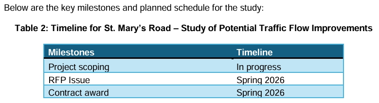
The city is in the process of commissioning a study to look at short term traffic flow improvements on St. Mary's:

Quote:
St. Mary’s Road / Downtown Corridor Study

Transportation2050 identified that some transportation corridors will need to change to take on new roles and new demands within the network, whereas other corridors will require some level of infrastructure upgrades to accommodate increased traffic, even with the impending shift to greater use of sustainable modes such as transit and active transportation. Consequently, several new, distinct corridor programs have been identified. These programs are:

• Rapid Transit Corridors Program
• Strategic Road Network (SRN) Program
• Multi-modal Corridors Program

The St. Mary’s corridor (Downtown to the Perimeter) is identified as a Rapid Transit dependent corridor (Transportation2050 Map 4). This corridor will eventually have a study led by Winnipeg Transit to determine corridor changes to allow for upgraded (rapid and/or high volume) transit service to be incorporated into the right-of-way, while continuing to permit vehicular travel. However, Winnipeg Transit is currently focusing on the Downtown Corridors (Portage Avenue and Main Street) and the Northern Corridor (Main Street from Sutherland Avenue to Inkster Boulevard).

Transportation2050 identifies this segment of St. Mary’s Road as a short-term road improvement need (2024-2033) with the footnote “St. Mary’s Road was advanced to the short term to undertake a corridor analysis study” (Transportation2050 Map 9). Subsequently, funding was identified in the Supplement to the 2025 Adopted Budget for the St. Mary’s Road (St. Anne’s Rd to Tache Ave) – Study of Potential Traffic Flow Improvements.

The purpose of the St. Mary’s Road (St. Anne’s Rd to Tache Ave) – Study of Potential Traffic Flow Improvements is to identify potential traffic flow and road safety improvements that can be implemented in the short to medium term at lower cost and without substantial changes to the St. Mary’s Road right-of-way. Significant changes to the roadway cross-section and right-of-way are not the goal of the study. More significant scale corridor changes may be considered as part of the future Rapid Transit corridor study.

Reply With Quote
     
     
  #13193  
Old Posted May 14, 2026, 4:04 PM
Mr Tall Forehead's Avatar
Mr Tall Forehead Mr Tall Forehead is online now
Registered User
 
Join Date: Jul 2024
Location: Winnipeg
Posts: 909
"The purpose of the St. Mary’s Road (St. Anne’s Rd to Tache Ave) – Study of Potential Traffic Flow Improvements is to identify potential traffic flow and road safety improvements that can be implemented in the short to medium term at lower cost and without substantial changes to the St. Mary’s Road right-of-way. Significant changes to the roadway cross-section and right-of-way are not the goal of the study. More significant scale corridor changes may be considered as part of the future Rapid Transit corridor study."

This really limits what solutions can be identified...other than maybe parking limitations and prohibiting left turns at a bunch of minor intersections. Left turners really slow the flow in the undivided stretch.
Reply With Quote
     
     
  #13194  
Old Posted May 14, 2026, 4:16 PM
Carboy15's Avatar
Carboy15 Carboy15 is offline
CanAutoroute1
 
Join Date: Oct 2022
Location: Centerville of Canada
Posts: 610
Quote:
Originally Posted by Mr Tall Forehead View Post
"The purpose of the St. Mary’s Road (St. Anne’s Rd to Tache Ave) – Study of Potential Traffic Flow Improvements is to identify potential traffic flow and road safety improvements that can be implemented in the short to medium term at lower cost and without substantial changes to the St. Mary’s Road right-of-way. Significant changes to the roadway cross-section and right-of-way are not the goal of the study. More significant scale corridor changes may be considered as part of the future Rapid Transit corridor study."

This really limits what solutions can be identified...other than maybe parking limitations and prohibiting left turns at a bunch of minor intersections. Left turners really slow the flow in the undivided stretch.
That Traverse/Coniston Intersection is awful for that. If it wasn't for the BRT Considerations, I'd just shrink St Mary's to a 2-lane divided roadway, and just put a roundabout there. But we know that can't be done for such a busy arterial. It would just create clogging.
Reply With Quote
     
     
  #13195  
Old Posted May 14, 2026, 4:52 PM
Wpg_Guy's Avatar
Wpg_Guy Wpg_Guy is online now
Moderator
 
Join Date: Aug 2002
Location: Winnipeg, Manitoba
Posts: 8,611
Quote:
Originally Posted by Mr Tall Forehead View Post
"The purpose of the St. Mary’s Road (St. Anne’s Rd to Tache Ave) – Study of Potential Traffic Flow Improvements is to identify potential traffic flow and road safety improvements that can be implemented in the short to medium term at lower cost and without substantial changes to the St. Mary’s Road right-of-way. Significant changes to the roadway cross-section and right-of-way are not the goal of the study. More significant scale corridor changes may be considered as part of the future Rapid Transit corridor study."

This really limits what solutions can be identified...other than maybe parking limitations and prohibiting left turns at a bunch of minor intersections. Left turners really slow the flow in the undivided stretch.
Public works mentioned they will be exploring reversible lanes, lanes that switch direction to handle rush hours, they specifically mentioned Calgary's use of them.
Reply With Quote
     
     
  #13196  
Old Posted May 14, 2026, 4:55 PM
Mr Tall Forehead's Avatar
Mr Tall Forehead Mr Tall Forehead is online now
Registered User
 
Join Date: Jul 2024
Location: Winnipeg
Posts: 909
Quote:
Originally Posted by Wpg_Guy View Post
Public works mentioned they will be exploring reversible lanes, lanes that switch direction to handle rush hours, they specifically mentioned Calgary's use of them.
Cool. Just like the old Main/Norwood Bridges or St James back when the Stadium and Arena were emptying out.
Reply With Quote
     
     
  #13197  
Old Posted May 14, 2026, 5:43 PM
cheswick's Avatar
cheswick cheswick is offline
Registered User
 
Join Date: Nov 2010
Location: South Kildonan
Posts: 3,012
Quote:
Originally Posted by Wpg_Guy View Post
Public works mentioned they will be exploring reversible lanes, lanes that switch direction to handle rush hours, they specifically mentioned Calgary's use of them.
We should definitely use these. I know Montreal has highways where they physically move barriers to accomplish lane directional changes during the day
Reply With Quote
     
     
  #13198  
Old Posted May 14, 2026, 6:13 PM
bomberjet bomberjet is offline
Registered User
 
Join Date: Nov 2012
Location: Winnipeg
Posts: 16,373
The lane switching thing wouldn't be the greatest with a median running BRT. Side running BRT on St Mary's could work but would require loss of access for some.

The case along St. Mary's isn't as bad as it looks. The City right of way is wider already in some location. "Wider". But it's hard to tell since the sidewalk is mostly at the curb, and not at the right of way.

In the northern portion, less demolitions needed. In the southern portion say from Caton, a bit more. But it's not full scale demolition of one side. I'll check what the preferred right of way would be for centre running BRT with 2 lanes either side.

Centre running get's messy when you have to make room for stations/stops. We'll see how they work it for the downtown corridors (Ie: it's get windy and not good for narrow row like St. Mary's.).

St. Mary's might be a good spot for dedicated curb lanes. Not diamond lanes, but separated with a barrier. And 4 traffic lanes in the middle. This is listed as an option in the transit master plan. Even downtown this might be the way to go.
Reply With Quote
     
     
  #13199  
Old Posted May 14, 2026, 7:00 PM
Carboy15's Avatar
Carboy15 Carboy15 is offline
CanAutoroute1
 
Join Date: Oct 2022
Location: Centerville of Canada
Posts: 610
Well, maybe for the Blue Line (which I consider the Mainline BRT) should of course try to be as seperate as possible. It would either have its own seperate BRT Way, and use the Median Lanes on Portage Ave, unless they just have BRT with both lanes on one side. The Blue Line would ensure Speed as a priority. My hope with BRT is that we can achieve something as close to Light Rail as possible.

The Frequent BRT Lines such as Rose and Orange should maybe just stick with the Curb Lanes for the most part. Especially where there's big box stores it would be rather scary to cross a massive stroad from a median BRT Lane.
Reply With Quote
     
     
  #13200  
Old Posted May 14, 2026, 7:33 PM
bomberjet bomberjet is offline
Registered User
 
Join Date: Nov 2012
Location: Winnipeg
Posts: 16,373
The orange and rose are to be separated mainline BRT similar to blue. Just not on a separate stand alone corridor like the southwest transitway. The downtown corridors plan has only a couple stations in the downtown on those lines and that's it. Orange on St. Mary's wouldn't have stops every block. It'd be like 600m intervals or something.
Reply With Quote
     
     
This discussion thread continues

Use the page links to the lower-right to go to the next page for additional posts
 
 
Reply

Go Back   SkyscraperPage Forum > Regional Sections > Canada > Manitoba & Saskatchewan
Forum Jump


Forum Jump


All times are GMT. The time now is 6:31 PM.


Powered by vBulletin® Version 3.8.7
Copyright ©2000 - 2026, vBulletin Solutions, Inc.