HomeDiagramsDatabaseMapsForum About
     

Go Back   SkyscraperPage Forum > Photography Forums > Found City Photos


Reply

 
Thread Tools Display Modes
     
     
  #821  
Old Posted Apr 20, 2026, 12:17 AM
Alkapone Alkapone is offline
 
Join Date: Nov 2016
Posts: 420
Quote:
Originally Posted by ethereal_reality View Post
I truly couldn't see what you were talking about until I enlarged it.


You're talking about this, right?


.

Exactly! And then there’s that odd traffic signal thing below it next to the telephone pole…like a target signal or a flash warning for a danger spot on a highway stretch.
Reply With Quote
     
     
  #822  
Old Posted Apr 20, 2026, 12:31 AM
Alkapone Alkapone is offline
 
Join Date: Nov 2016
Posts: 420
Quote:
Originally Posted by ethereal_reality View Post
.
I double checked my file and found one more of the '3966 Mission Road' photographs...They obviously made great strides by this point in time.


eBay


um. . .office of WHAT?


.
Looking at this shot, could the guy in photo 1 be cutting fence materials to go by the highway? And that raises the question of whether the much better cattle fencing along the hillside is protecting a rail line up there rather than this open roadway? If so, it would probably be the Southern Pacific main heading east to Arizona (the old Yuma Division beyond Los Angeles territory) on the Sunset Route. So that could explain the signal up there.
Reply With Quote
     
     
  #823  
Old Posted Apr 20, 2026, 4:49 AM
Noir_Noir Noir_Noir is offline
 
Join Date: Feb 2018
Posts: 601
Quote:
Originally Posted by ethereal_reality View Post
.


This last one is especially intriguing because, unless I am seeing things, there is a large sign made out of cut letters on top of the hill in the background!


Quote:
Originally Posted by Alkapone View Post
Given the letter spacing before the “S”, possibly for NEWMARK’S Coffee by the Newmark Brothers of Los Angeles? But what’s this lower on the hill…

Quote:
Originally Posted by ethereal_reality View Post


You're talking about this, right?


Here a panoramic view from 1924 of Ascot Motor Speedway in City Terrace.


hdl.huntington.org


The speedway was located not far south of 3966 Mission Road, the location of the ebay pictures.

On the high resolution version of the picture a zoom to the highlighted area gives this rear view of a sign in the hills.


One quick flip later we get our sign.


By November of 1924 another picture shows what maybe a direction sign to Ascot has been placed close by the Newmark's sign.


hdl.huntington.org


That sign lower on the hill also says "Ascot", likely advertising the speedway.
Reply With Quote
     
     
  #824  
Old Posted Apr 20, 2026, 5:03 AM
Flyingwedge's Avatar
Flyingwedge Flyingwedge is offline
 
Join Date: Jun 2012
Posts: 1,224
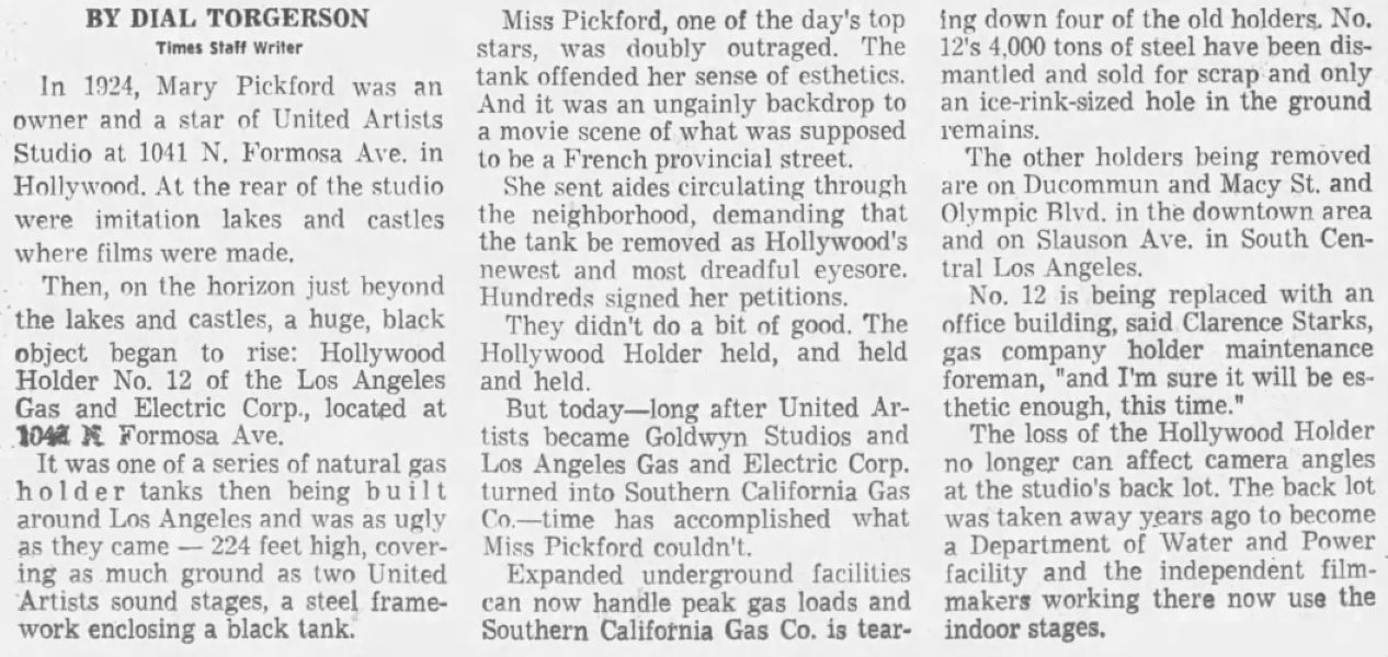
Gasometers

I'm a little late to the party on this, but I think most of the gasometer dismantling occurred c. 1971-74.

This article describes how Many Pickford hated the gas holder at Formosa Avenue just south of Santa Monica Blvd., which was one of
four being torn down:


November 26, 1971, Los Angeles Times @ Newspapers.com


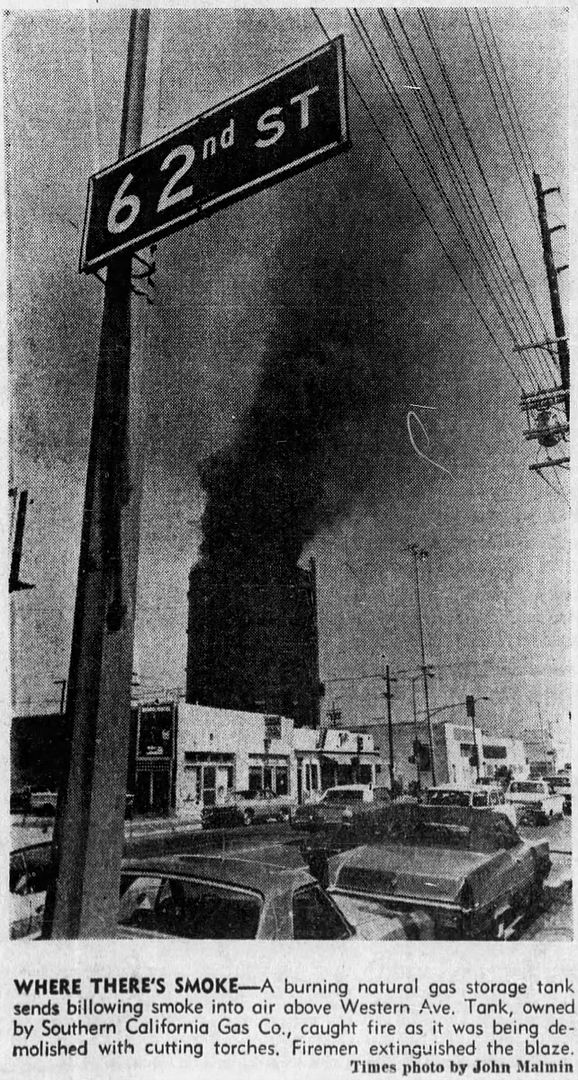
This photo caption describes the gasometer near Slauson and Western as being the 4th of 9 gasometers to be taken down:


August 24, 1972, Southwest Topics-Wave @ Newspapers.com


That gasometer had previously caught fire while it was being dismantled:


June 29, 1972, Los Angeles Times @ Newspapers.com


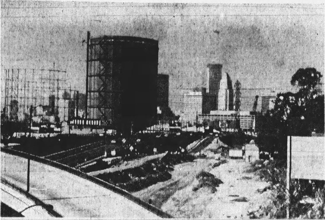
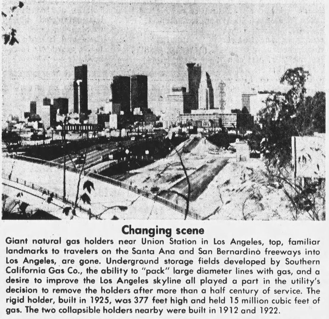
I can't see why these before-and-after photos were run in April 1974 unless the gasometers in the top photo had recently come down:


April 4, 1974, Highland Park News-Herald and Journal @ Newspapers.com

Last edited by Flyingwedge; Apr 20, 2026 at 5:26 AM.
Reply With Quote
     
     
  #825  
Old Posted Apr 20, 2026, 5:29 AM
Alkapone Alkapone is offline
 
Join Date: Nov 2016
Posts: 420
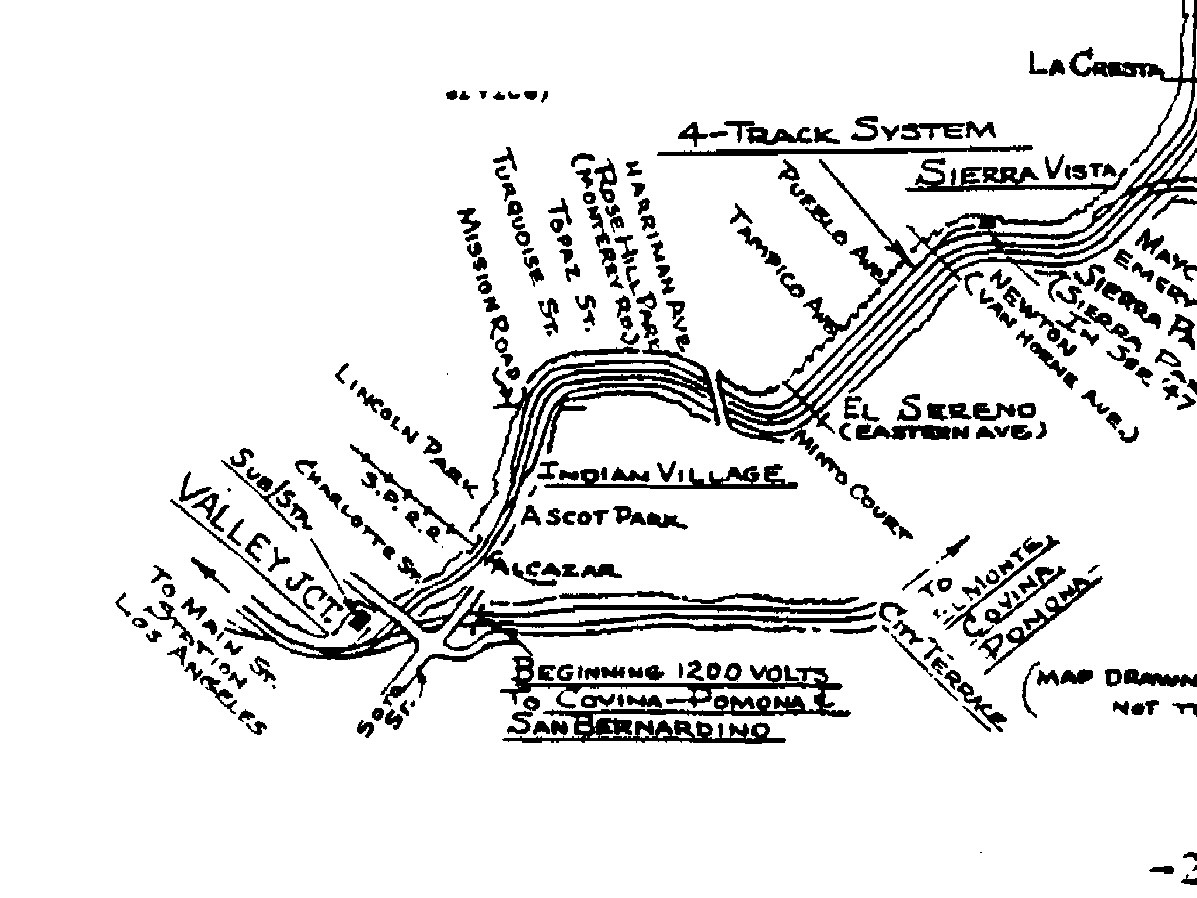
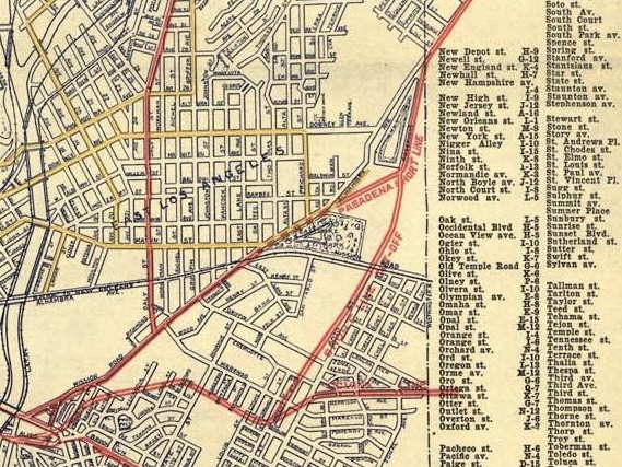
And since Noir Noir found the Ascot Park side of the hills, we can conclude this is North Mission Road and neither East Mission Road nor any Mission Streets. In short, that’s got to be Pacific Electric Railway trackage probably somewhere near the Indian Village area as portrayed on maps (originally generated by Raymond E. Younghans for Special 16 Lines of the Pacific Electric) and available on Wikimedia as here cropped to highlight that area:


sourced via wikimedia.
Reply With Quote
     
     
  #826  
Old Posted Apr 20, 2026, 2:52 PM
Scott Charles's Avatar
Scott Charles Scott Charles is offline
 
Join Date: Jan 2018
Posts: 715
Quote:
Originally Posted by Flyingwedge View Post
I can't see why these before-and-after photos were run in April 1974 unless the gasometers in the top photo had recently come down:


April 4, 1974, Highland Park News-Herald and Journal @ Newspapers.com
Wow, well done, Flyingwedge!

I agree with you completely – I can't imagine the newspaper waiting until 1974 to print the above photos if the gasometers had been torn down years (or even months) earlier. By definition, newspapers print things that are new... that's why they're not called oldspapers!

Quote:
The word “news” comes from the adjective “new.” In late Middle English (around the 14th–15th century), people started using “newes” to mean “new information” or “recent reports.”
Reply With Quote
     
     
  #827  
Old Posted Apr 20, 2026, 4:07 PM
Martin Pal Martin Pal is offline
 
Join Date: Sep 2013
Posts: 2,725
Flyingwedge, speaking of the gasometer on Formosa, south of Santa Monica Blvd., that Mary Pickford wasn't fond of, and I don't blame her, I don't know if it got caught on camera much in any of the films and TV series filmed at that location, but it does make an imposing appearance in a Best Picture winner: The Best Years of Our Lives.

AndrewSideA

Last edited by Martin Pal; Apr 20, 2026 at 4:18 PM.
Reply With Quote
     
     
  #828  
Old Posted Apr 20, 2026, 4:16 PM
ethereal_reality's Avatar
ethereal_reality ethereal_reality is offline
 
Join Date: Feb 2008
Posts: 18,086
.
.................................SOLVED!


Quote:
Originally Posted by odinthor View Post

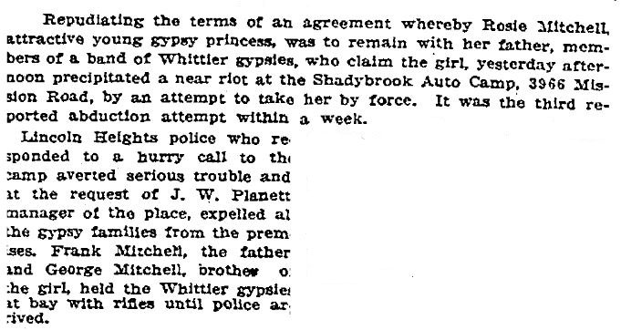
e_r, this was the Shadybrook Auto Camp:


LA Times, 10/18/1924
FANTASTIC SLEUTHING, ODINTHOR!!!

Honestly, I didn't think we would ever figure out why the eBay seller was using the 3966 Mission Road address. ..Now it all falls into place.

.

Last edited by ethereal_reality; Apr 20, 2026 at 4:50 PM.
Reply With Quote
     
     
  #829  
Old Posted Apr 20, 2026, 6:02 PM
HossC's Avatar
HossC HossC is offline
 
Join Date: Aug 2013
Posts: 4,737
Quote:
Originally Posted by ethereal_reality View Post

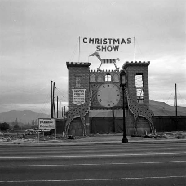
I happened upon this snapshot earlier today on eBay


eBay

We've seen this elaborate entrance to a 'Christmas show' many years ago on NLA but I don't remember where (along Wilshire) it was located.
I'm sure I also remember it from the old thread, but Google's site search doesn't seem to work nearly as well as it used to.

Here's another picture of the entrance that I found on Facebook.
Looking north across Wilshire Boulevard at the entrance to Santa's Circus, 5843 Wilshire Boulevard in Hancock Park. It was one of the activities offered at the Christmas Show held to benefit the British War Relief Association of Southern California, 1940

Facebook
Reply With Quote
     
     
  #830  
Old Posted Apr 20, 2026, 6:32 PM
Alkapone Alkapone is offline
 
Join Date: Nov 2016
Posts: 420
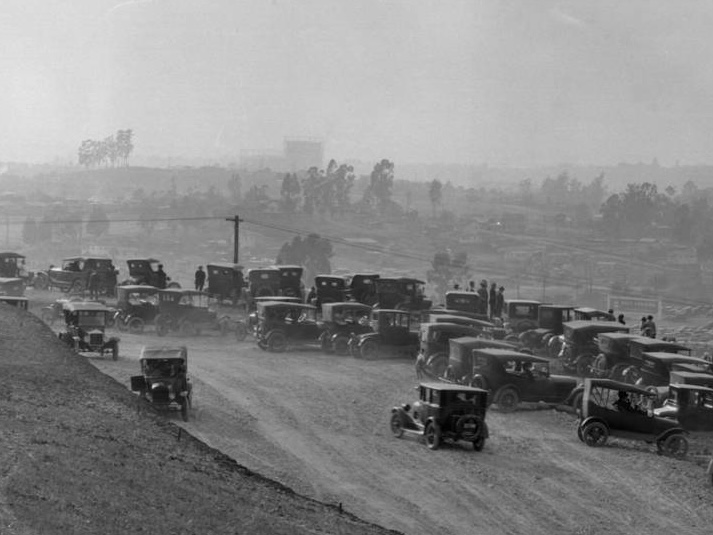
Not to get too over excited about coincidences in different subject postings, but did anyone notice the gazzo tanks appearing in the back of Noir Noir’s Legion Ascot link to the photo at Huntington? Looky here past the autos on the left section:

Reply With Quote
     
     
  #831  
Old Posted Apr 20, 2026, 6:36 PM
ethereal_reality's Avatar
ethereal_reality ethereal_reality is offline
 
Join Date: Feb 2008
Posts: 18,086
.
Thanks for answering my question about the war-time Christmas Show, Hoss... I was afraid my question had gotten lost.

Did you happen to notice one of the questions in the comments (on facebook) about a live reindeer?

This one:

"Anyone remember the real live reindeer atop the roof of some insurance bldg on Wilshire Blvd. just east of Highland?"

Now I want to know ALL abou that!
.

Last edited by ethereal_reality; Apr 20, 2026 at 7:11 PM.
Reply With Quote
     
     
  #832  
Old Posted Apr 20, 2026, 7:17 PM
Snix Snix is offline
 
Join Date: Jun 2016
Posts: 222

eBay

I've long been fascinated with the Lawry's empire along La Cienega. They kept the real estate but sort of musical chairs'd it. The original 1938 Lawry's was on the east side of the street and became Stears for Steaks when they built the new Wayne McAllister-designed Lawry's on the west side of the street in 1947. This photo shows that restaurant after an early 1960s remodel. Lawry's relocated to its original site with a new building constructed in 1993. The family had another restaurant called Richlor's just north of the original Lawry's which became Mediterranea in 1961. I can't make out what's between that and the Flying A station.
Reply With Quote
     
     
  #833  
Old Posted Apr 20, 2026, 7:23 PM
Alkapone Alkapone is offline
 
Join Date: Nov 2016
Posts: 420
Quote:
Originally Posted by ethereal_reality View Post
.
.................................SOLVED!


FANTASTIC SLEUTHING, ODINTHOR!!!

Honestly, I didn't think we would ever figure out why the eBay seller was using the 3966 Mission Road address. ..Now it all falls into place.

.
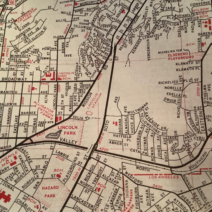
From my c.1954 Auto Club map, just about across from Duke Street below Broadway (where the 4000 block begins) with the PE tracks (Private ROW) being off to the right where Soto Street ran alongside, giving that line of sight to the Ascot Hills area with the Coffee advert.:


I believe an LARy shot (on PERYHS site) of the “9”-line looking along by Lincoln High views those hills just after a fire came through there. Probably not a good place to set up an auto camp!
Reply With Quote
     
     
  #834  
Old Posted Apr 20, 2026, 7:41 PM
Alkapone Alkapone is offline
 
Join Date: Nov 2016
Posts: 420
Quote:
Originally Posted by Snix View Post

eBay

I've long been fascinated with the Lawry's empire along La Cienega. They kept the real estate but sort of musical chairs'd it. The original 1938 Lawry's was on the east side of the street and became Stears for Steaks when they built the new Wayne McAllister-designed Lawry's on the west side of the street in 1947. This photo shows that restaurant after an early 1960s remodel. Lawry's relocated to its original site with a new building constructed in 1993. The family had another restaurant called Richlor's just north of the original Lawry's which became Mediterranea in 1961. I can't make out what's between that and the Flying A station.

If I understand this, you want to know what’s under that odd crown-and-wings like signage between the Flying A and the yellowish sign that might read Restaurants along its’ bottom? Perhaps an optical illusion but it seems to have an archway (flat) leading from a driveway into an open court area (with sun light hitting inside?). Might that not go with the yellow sign and the other one is actually further beyond?
Reply With Quote
     
     
  #835  
Old Posted Apr 20, 2026, 8:54 PM
Alkapone Alkapone is offline
 
Join Date: Nov 2016
Posts: 420
Quote:
Originally Posted by ethereal_reality View Post
I truly couldn't see what you were talking about until I enlarged it.


You're talking about this, right?


.
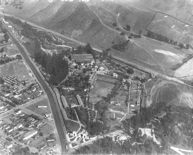
And here’s our aerial from 1924 c/o E.S.H.S. : https://www.facebook.com/photo/?fbid=558726324202767


Up by the triangular meet, look toward the group of structures below the rail line and running up a line from the mass of trees that thing on the lower hill is visible:


source FB as above.
Reply With Quote
     
     
  #836  
Old Posted Apr 20, 2026, 9:18 PM
HossC's Avatar
HossC HossC is offline
 
Join Date: Aug 2013
Posts: 4,737


The Selig Zoo can be seen at the bottom of the image.
Reply With Quote
     
     
  #837  
Old Posted Apr 20, 2026, 10:21 PM
Alkapone Alkapone is offline
 
Join Date: Nov 2016
Posts: 420
Quote:
Originally Posted by HossC View Post


The Selig Zoo can be seen at the bottom of the image.

And it gets even more bizzare with every go around. Before the Los Angeles Inter-urban (LAIU) built that line along the hillsides, the original route of the Pasadena Short Line ran on Mission Road to a turn north on Alhambra Avenue (renamed North Mission Road here after a name switch). From there it was supposed to run up the road to reach Indian Village. But a period transit map shows a quick deviation right across this section above Selig Zoo to connect to the upoer part of that hillside line area. How? Was there a trestle or bridgework across this slump? Are the guys in the auto camp re-using wood from such a structure if it was abandoned in 1907? We may have a tough time finding any earlier images. So who can explain this map detail? (Note that Downey Avenue is what became Broadway on the later maps.)


Reply With Quote
     
     
  #838  
Old Posted Apr 20, 2026, 11:50 PM
Alkapone Alkapone is offline
 
Join Date: Nov 2016
Posts: 420
Re: N. Mission Road auto camp/Selig Zoo lands…Henry Huntington sold 33 acres of land to Selig. The 1921 Baist map seems to hold some clues. In the upper section with the newer LAIU-built line, there’s a stub of track below the reservoir site which points toward the now Selig lands. It could be what was left of the original Short Line connection:
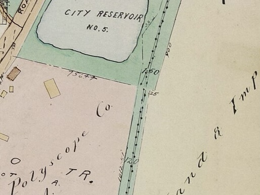


Additionally, at the entrance to the Zoo there’s another stub which is beyond the LARy line into the area (Broadway-Lincoln-Mission) and perhaps is another remnant of the old PERy R.O.W. (with guage conversions?):
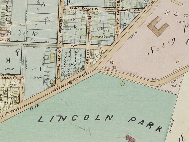


All Baist originally sourced from USC (dead link).

Some line or arc between those points could be where the 1902-06 cars ran through, with the auto camp built north of it later. But what happened to the reservoir? Was the auto camp sitting where flash floods could occur?

Reply With Quote
     
     
  #839  
Old Posted Apr 21, 2026, 6:14 AM
JeffDiego JeffDiego is offline
 
Join Date: Nov 2009
Posts: 258
Quote:
Originally Posted by Lwize View Post
From the LA Times:
Utterly sad. Clifton's Cafeteria owner gives up. To state the obvious, a basic issue here is untreated mental illness, which America's urban streets are awash in, with little or no medical or social infrastructure to deal with the problem - so businesses just leave.
Reply With Quote
     
     
  #840  
Old Posted Apr 21, 2026, 4:56 PM
ethereal_reality's Avatar
ethereal_reality ethereal_reality is offline
 
Join Date: Feb 2008
Posts: 18,086
Quote:
Originally Posted by Alkapone View Post


But what happened to the reservoir? Was the auto camp sitting where flash floods could occur?

If I remember correctly- due to heavy rains Reservoir #5 burst wiping out a bunch of cars that were parked at a roadhouse!
-We touched on it in the early years of the thread over a decade ago. .
and YES, there are photographs (well, at least one, which I am unable to find)


I'm hoping someone will remember the earlier post & find the photograph.
.

Last edited by ethereal_reality; Apr 21, 2026 at 5:11 PM.
Reply With Quote
     
     
This discussion thread continues

Use the page links to the lower-right to go to the next page for additional posts
   
Reply

Go Back   SkyscraperPage Forum > Photography Forums > Found City Photos
Forum Jump


Forum Jump


All times are GMT. The time now is 10:08 AM.


Powered by vBulletin® Version 3.8.7
Copyright ©2000 - 2026, vBulletin Solutions, Inc.