HomeDiagramsDatabaseMapsForum About
     

Go Back   SkyscraperPage Forum > Regional Sections > Canada > Ontario > Ottawa-Gatineau > Downtown & Urban Ottawa


Reply

 
Thread Tools Display Modes
     
     
  #41  
Old Posted Jan 27, 2026, 8:52 PM
J.OT13's Avatar
J.OT13 J.OT13 is online now
Moderator
 
Join Date: Mar 2012
Location: Ottawa
Posts: 28,576
Quote:
Originally Posted by Uhuniau View Post
They don't look very along-the-edge in those images.
Along the edge of the street here, with a park in between the roads.


Here as well, they are along the edge.


Image that shows Bronson has a generous buffer because Bronson is a highway.
Reply With Quote
     
     
  #42  
Old Posted Jan 28, 2026, 1:43 AM
lrt's friend lrt's friend is offline
Registered User
 
Join Date: Dec 2006
Posts: 12,749
Put all these towers up and Line 2 will be beyond capacity.
Reply With Quote
     
     
  #43  
Old Posted Jan 28, 2026, 2:45 AM
Williamoforange's Avatar
Williamoforange Williamoforange is offline
Registered User
 
Join Date: Sep 2020
Location: Ottawa
Posts: 857
Quote:
Originally Posted by lrt's friend View Post
Put all these towers up and Line 2 will be beyond capacity.
I doubt this, Tunneys, the old federal training area, or the one off of Tremblay will ever get farther then a tower or two before line 2 his capacity from other developments

All of which have the same issue of terrible urban planning or more specifically the planning of someone who takes " new urbanism" & strong towns as a guide for the planning of cities.
Reply With Quote
     
     
  #44  
Old Posted Jan 28, 2026, 3:39 PM
Uhuniau Uhuniau is offline
Registered User
 
Join Date: Jan 2010
Posts: 9,005
Quote:
Originally Posted by J.OT13 View Post
Along the edge of the street here, with a park in between the roads.
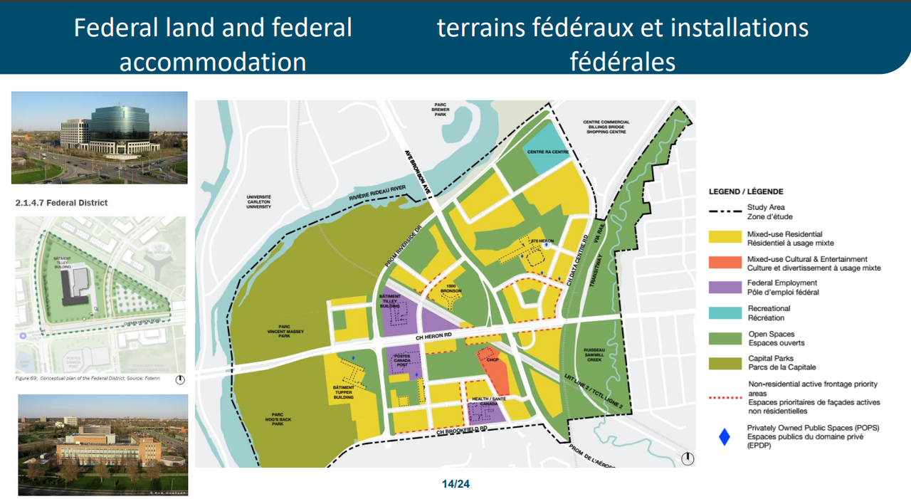
The map shows buildings set well back from the stroad frontages. Is the map as imaginary as the "Demonstration Images", whatever a "demonstration image" is?
__________________
___
Enjoy my taxes, Orleans (and Kanata?).
Reply With Quote
     
     
  #45  
Old Posted Jan 28, 2026, 4:11 PM
Williamoforange's Avatar
Williamoforange Williamoforange is offline
Registered User
 
Join Date: Sep 2020
Location: Ottawa
Posts: 857
Quote:
Originally Posted by Uhuniau View Post
The map shows buildings set well back from the stroad frontages. Is the map as imaginary as the "Demonstration Images", whatever a "demonstration image" is?
The images specifically the second one also show the buildings back from the edge, mostly so they can fit street trees in, which great but they need to remove the street parking so the ROW can be narrowed.
Reply With Quote
     
     
  #46  
Old Posted Jan 28, 2026, 5:30 PM
OTownandDown OTownandDown is offline
Registered User
 
Join Date: Jul 2018
Posts: 1,607
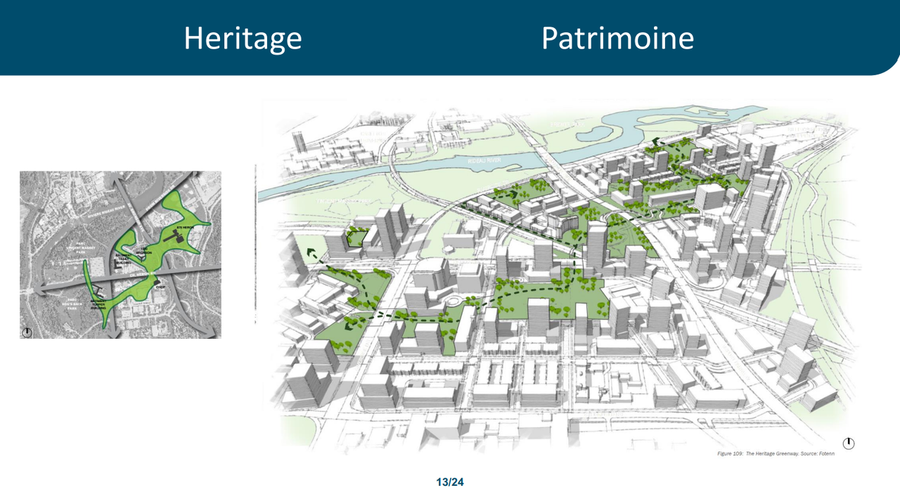
The first image, noting the 'Central Heating Plant' is showing that Canada Post, its parking garage, and surrounding rental office buildings are obliterated? The parking garage is currently right where the soccer pitch is.
Reply With Quote
     
     
  #47  
Old Posted Jan 28, 2026, 6:44 PM
rocketphish's Avatar
rocketphish rocketphish is offline
Planet Ottawa and beyond
 
Join Date: Feb 2009
Location: Greater Ottawa
Posts: 14,529
Quote:
Originally Posted by OTownandDown View Post
The first image, noting the 'Central Heating Plant' is showing that Canada Post, its parking garage, and surrounding rental office buildings are obliterated? The parking garage is currently right where the soccer pitch is.
You can see from the tiny little key map in the top-right corner that the large parking structure and surrounding lots are indeed gone (good riddance), but the main Canada Post buildings remain. They are behind the point-of-view.
Reply With Quote
     
     
  #48  
Old Posted Apr 1, 2026, 4:15 PM
rocketphish's Avatar
rocketphish rocketphish is offline
Planet Ottawa and beyond
 
Join Date: Feb 2009
Location: Greater Ottawa
Posts: 14,529
The DevApp has been posted:
https://devapps.ottawa.ca/en/applications/D01-01-25-0006/details

I like this view:

Reply With Quote
     
     
  #49  
Old Posted Apr 3, 2026, 7:04 PM
J.OT13's Avatar
J.OT13 J.OT13 is online now
Moderator
 
Join Date: Mar 2012
Location: Ottawa
Posts: 28,576
I need to see some concrete plans from the City on double tracking Line 2.
Reply With Quote
     
     
  #50  
Old Posted Apr 4, 2026, 2:13 AM
ponyboycurtis's Avatar
ponyboycurtis ponyboycurtis is offline
Cigritbutt enthusiast
 
Join Date: Apr 2021
Location: Blahttawa
Posts: 1,626
Quote:
Originally Posted by J.OT13 View Post
I need to see some concrete plans from the City on double tracking Line 2.
Indeed.

Confederation Heights is a comically terrible waste of land in its current configuration.
__________________
I don't understand how communism works.
Reply With Quote
     
     
  #51  
Old Posted Apr 5, 2026, 10:22 PM
lrt's friend lrt's friend is offline
Registered User
 
Join Date: Dec 2006
Posts: 12,749
Quote:
Originally Posted by J.OT13 View Post
I need to see some concrete plans from the City on double tracking Line 2.
There is no plan. Another 5 year shutdown, so it is not really feasible. Not in my lifetime.

It is just like REM in Montreal, where they planned to insert a station after the line opened. Not possible without a lengthy shutdown of the line, so it won't happen.
Reply With Quote
     
     
  #52  
Old Posted Apr 6, 2026, 3:51 PM
J.OT13's Avatar
J.OT13 J.OT13 is online now
Moderator
 
Join Date: Mar 2012
Location: Ottawa
Posts: 28,576
Quote:
Originally Posted by lrt's friend View Post
There is no plan. Another 5 year shutdown, so it is not really feasible. Not in my lifetime.

It is just like REM in Montreal, where they planned to insert a station after the line opened. Not possible without a lengthy shutdown of the line, so it won't happen.
It's not impossible to add an infill station without lengthy complete shutdowns. Vancouver is a prime example, recently completing Capstan Station.

If a City/transit agency respects its transit riders, they will find a way to build infills with minimal disruptions.

Unfortunately, the City of Ottawa/OC Transpo have proven time and time again that they don't respect transit riders and will find the cheapest option instead of the least disruptive option (and in the case of the entire Stage 2 south project, the cheapest option instead of the option that could deliver the best improvement for riders).
Reply With Quote
     
     
  #53  
Old Posted Apr 6, 2026, 10:15 PM
lrt's friend lrt's friend is offline
Registered User
 
Join Date: Dec 2006
Posts: 12,749
Quote:
Originally Posted by J.OT13 View Post
It's not impossible to add an infill station without lengthy complete shutdowns. Vancouver is a prime example, recently completing Capstan Station.

If a City/transit agency respects its transit riders, they will find a way to build infills with minimal disruptions.

Unfortunately, the City of Ottawa/OC Transpo have proven time and time again that they don't respect transit riders and will find the cheapest option instead of the least disruptive option (and in the case of the entire Stage 2 south project, the cheapest option instead of the option that could deliver the best improvement for riders).
The promised Griffintown infill REM station seems to be indefinitely deferred. Just like the Line 2 infill stations which took many years to build and this could only be accomplished during a lengthy line shutdown. It may be possible to build infills, but it is very challenging to do so on an active line. I wouldn't hold my breath on any proposed infill stations. So, it is highly unlikely that other originally proposed stations will be added to the Line 1 eastern extension. Build it during initial construction or we will be waiting for many, many years.

Line 2 double tracking is much more complicated than building an infill station. We can argue technical possibilities but I just don't see it happening. We built a line with no realistic expansion. I know I am being a Debbie Downer, but I just don't see it happening for decades to come. I have said it before, but we may be better off thinking of a Bank Street subway to expand capacity.

https://www.cbc.ca/news/canada/montreal/rem-griffintown-station-montreal-9.6983416

Last edited by lrt's friend; Apr 6, 2026 at 10:34 PM.
Reply With Quote
     
     
  #54  
Old Posted Apr 7, 2026, 8:19 PM
Uhuniau Uhuniau is offline
Registered User
 
Join Date: Jan 2010
Posts: 9,005
I don't think some of the things we think of as complicated and difficult are viewed in the same way in certain other international jurisdictions.
__________________
___
Enjoy my taxes, Orleans (and Kanata?).
Reply With Quote
     
     
  #55  
Old Posted Apr 8, 2026, 1:13 PM
J.OT13's Avatar
J.OT13 J.OT13 is online now
Moderator
 
Join Date: Mar 2012
Location: Ottawa
Posts: 28,576
Quote:
Originally Posted by lrt's friend View Post
The promised Griffintown infill REM station seems to be indefinitely deferred. Just like the Line 2 infill stations which took many years to build and this could only be accomplished during a lengthy line shutdown. It may be possible to build infills, but it is very challenging to do so on an active line. I wouldn't hold my breath on any proposed infill stations. So, it is highly unlikely that other originally proposed stations will be added to the Line 1 eastern extension. Build it during initial construction or we will be waiting for many, many years.

Line 2 double tracking is much more complicated than building an infill station. We can argue technical possibilities but I just don't see it happening. We built a line with no realistic expansion. I know I am being a Debbie Downer, but I just don't see it happening for decades to come. I have said it before, but we may be better off thinking of a Bank Street subway to expand capacity.

https://www.cbc.ca/news/canada/montreal/rem-griffintown-station-montreal-9.6983416
It's disappointing that they delayed the Griffintown station, one of the few urban locations, and you're right, it might never happen. Same with any of the infill stations in Ottawa (Gloucester High Station is the most friutrating for me).

Line 2 will need to be upgraded at some point to at least 8 minute service due to the significant TOD and major trauma centre u/c. Dow's Lake station could be dangerously overcrowded once the new Civic opens. Confederation heights as well as this are redevelops.

At some point though, a second n/s line (Bank) will be needed to take the pressure off Line 2 and Line 1 at Bayview Station.
Reply With Quote
     
     
  #56  
Old Posted Apr 8, 2026, 2:37 PM
lrt's friend lrt's friend is offline
Registered User
 
Join Date: Dec 2006
Posts: 12,749
Quote:
Originally Posted by J.OT13 View Post
It's disappointing that they delayed the Griffintown station, one of the few urban locations, and you're right, it might never happen. Same with any of the infill stations in Ottawa (Gloucester High Station is the most friutrating for me).

Line 2 will need to be upgraded at some point to at least 8 minute service due to the significant TOD and major trauma centre u/c. Dow's Lake station could be dangerously overcrowded once the new Civic opens. Confederation heights as well as this are redevelops.

At some point though, a second n/s line (Bank) will be needed to take the pressure off Line 2 and Line 1 at Bayview Station.
TOD is planned at Bayview, Gladstone, Carling, Confederation Heights, Walkley, South Keys and Limebank. How is this going to work with the limitations of Line 2?

There is no real upgrade path that is even somewhat achievable. If we wanted 8 minute frequency, how is this possible without full double tracking?

For example, if we ran a train every 8 minutes and didn't double track the Dow's Lake tunnel, that is a train every 4 minutes through the tunnel. Is that really feasible or safe? Likewise, at South Keys. We had difficulties finding a solution with 12 minute frequency, one of the reasons why opening was delayed so long. I watched the testing quite regularly and I saw the issues. Right now, there are 10 trains per hour on the south bound track at South Keys. If we increase frequency to 8 minutes, this increases the number of trains to 15 per hour, a train every 4 minutes on that south bound platform. Is it possible to get an airport train from the airport spur to South Keys station and back in less than 8 minutes?

Then, can we get the airport train to the airport in less than 8 minutes?

If we want to interline airport and Riverside South trains, we need to up the frequency to 7.5 minutes, which means that frequency has to be reduced south of South Keys on both corridors to 15 minutes. But, this also puts more pressure on the Dow's Lake tunnel. And then we introduce a further problem by having every second train at half length.

We have built very expensive infrastructure with so little flexibility for the future. We saved money in the short-term but we will pay a big price to ever upgrade this line.

Even the theory that double tracking Walkley Station would give us 10 minute frequency is not likely workable when you consider the limitations at South Keys station. I spoke to OC staff during public meetings when Line 2 testing was beginning and they were giving me BS when they told me that they would try for 10 minute frequency and better bus connectivity at stations. Lying at public meetings about Line 2 was routine to avoid addressing the difficult issues.
'
The blessing with Line 2 is the three Park n Ride lots, given the poor bus connectivity.

Last edited by lrt's friend; Apr 8, 2026 at 3:26 PM.
Reply With Quote
     
     
  #57  
Old Posted Apr 8, 2026, 3:00 PM
Richard Eade Richard Eade is offline
Registered User
 
Join Date: Mar 2008
Location: Nepean
Posts: 2,587
This is the thing. With the development and redevelopment happening along Line 2, more north-south transit capacity will be needed. And it is not as far into the future as people might believe. A second north-south line will be needed.

As always, things will get more expensive the longer we wait. And, if Line 2 is incrementally increased in capacity – although not enough to handle the future north-south demand – it will become increasingly indispensable.

Also of concern is the transit nightmare along Bank Street. Sure, dedicated, and semi-dedicated, transit lanes might help a bit, but they are not a real solution for moving a lot of people along that corridor. Bus lanes were added to Albert and Slater, and they were considered a blight that had to be removed.

The solution is a shallow subway running under Bank Street, from Billings Bridge to Wellington – or, even better, across the Ottawa River, into Gatineau. Trains from south of Billings Bridge must also have access to running in the subway. i.e., there should be a completely double-tracked route from Riverside South to Bank at Wellington. And this subway should be built soon – before the next shut-down of Line 2.

If Line 2 is off-loaded of passengers who are traveling directly from the south to the core, and vice-versa, I think that we will find that Line 2’s current configuration will handle the remaining demand for many years. When it does need to be shut-down and double-tracked, there will already be an alternative north-south line in operation to help take the load.
Reply With Quote
     
     
  #58  
Old Posted Apr 8, 2026, 3:16 PM
lrt's friend lrt's friend is offline
Registered User
 
Join Date: Dec 2006
Posts: 12,749
Quote:
Originally Posted by Richard Eade View Post
This is the thing. With the development and redevelopment happening along Line 2, more north-south transit capacity will be needed. And it is not as far into the future as people might believe. A second north-south line will be needed.

As always, things will get more expensive the longer we wait. And, if Line 2 is incrementally increased in capacity – although not enough to handle the future north-south demand – it will become increasingly indispensable.

Also of concern is the transit nightmare along Bank Street. Sure, dedicated, and semi-dedicated, transit lanes might help a bit, but they are not a real solution for moving a lot of people along that corridor. Bus lanes were added to Albert and Slater, and they were considered a blight that had to be removed.

The solution is a shallow subway running under Bank Street, from Billings Bridge to Wellington – or, even better, across the Ottawa River, into Gatineau. Trains from south of Billings Bridge must also have access to running in the subway. i.e., there should be a completely double-tracked route from Riverside South to Bank at Wellington. And this subway should be built soon – before the next shut-down of Line 2.

If Line 2 is off-loaded of passengers who are traveling directly from the south to the core, and vice-versa, I think that we will find that Line 2’s current configuration will handle the remaining demand for many years. When it does need to be shut-down and double-tracked, there will already be an alternative north-south line in operation to help take the load.
When you consider intensification planned for Billings Bridge, Lansdowne and the old bus terminal and also scattered intensification on the Bank corridor, I don't know how all this is sustainable with buses in mixed traffic or sporadic bus lanes. You will notice that nothing is going on at Billings Bridge. How long will those projects be deferred given the transportation limitations at the site, let alone redevelopment of the shopping centre as well.

A Bank Street subway will likely mean that the current level of service on Line 2 will be sufficient for a very long time.
Reply With Quote
     
     
  #59  
Old Posted Jun 24, 2026, 12:41 PM
J.OT13's Avatar
J.OT13 J.OT13 is online now
Moderator
 
Join Date: Mar 2012
Location: Ottawa
Posts: 28,576
Reply With Quote
     
     
  #60  
Old Posted Jun 25, 2026, 12:53 AM
rocketphish's Avatar
rocketphish rocketphish is offline
Planet Ottawa and beyond
 
Join Date: Feb 2009
Location: Greater Ottawa
Posts: 14,529
NCC approves plan for Ottawa's 'underutilized' Confederation Heights
Federal campus south of Carleton University ripe for 'mixed-use residential development,' NCC says

Cassandra Bellefeuille · CBC News
Posted: Jun 24, 2026 4:00 AM EDT | Last Updated: June 24


The National Capital Commission (NCC) has approved a master plan for the redevelopment of a parcel of prime federal land in Ottawa that a Crown corporation considers "underutilized."

Canada Lands Company and Public Services and Procurement Canada (PSPC) have been working to find new uses for federal sites including the Confederation Heights campus south of Carleton University.

On Tuesday, the NCC board approved recommendations for turning the area where Bronson Avenue, Heron Road and Riverside Drive meet into a new community.

Part of the process is the NCC allowing the sale of federal land and buildings.

Most of the land would be used for mixed-use residential development of three- to 40-storey buildings, according to the NCC.

The plan also includes a "heritage greenway" with public amenities, and involves the potential redevelopment of three buildings that are classified as federal heritage properties:
  • The Edward Drake Building at 1500 Bronson Ave., formerly CBC's headquarters in Ottawa, called the "jewel" of the Confederation Heights campus by the NCC.
  • The Canada Revenue Agency headquarters and Tax Data Centre at 875 Heron Rd.
  • The Sir Charles Tupper Building at 2720 Riverside Dr., designed as headquarters for the Department of Public Works in 1960 and one of five original buildings at Confederation Heights.

Other buildings in the area including Canada Post, Health Canada and the Tilley buildings are being retained for federal use

Any properties that are removed from the federal heritage list must be reclassified by the City of Ottawa under the Ontario Heritage Act, the NCC said.

The project would also improve access to nearby parks and adjust the boundaries of Hog's Back Park, and include a dedicated area for a recreational complex near Billings Bridge transit station, and a potential cultural and entertainment district near Mooney’s Bay transit station.

"There is an opportunity for many thousands of future residents to live there," NCC CEO Tobi Nussbaum said Tuesday of the potential redevelopment, calling it "hugely important" for the nation's capital.

"This is a project that will evolve over many years, I might even say decades."

In November 2021, Canada Lands and PSPC launched a public engagement process, and have since developed concept plans and drafted a master plan.

https://www.cbc.ca/news/canada/ottawa/co...lopment-community-construction-9.7246299

Reply With Quote
     
     
End
 
 
Reply

Go Back   SkyscraperPage Forum > Regional Sections > Canada > Ontario > Ottawa-Gatineau > Downtown & Urban Ottawa
Forum Jump


Forum Jump


All times are GMT. The time now is 9:37 PM.

     
SkyscraperPage.com - Privacy Statement - Top

Powered by vBulletin® Version 3.8.7
Copyright ©2000 - 2026, vBulletin Solutions, Inc.