HomeDiagramsDatabaseMapsForum About
     

Go Back   SkyscraperPage Forum > Discussion Forums > City Discussions


View Poll Results: Is the Midwest one region?
Yes 18 21.95%
No, split between Great Lakes and Great Plains 64 78.05%
Voters: 82. You may not vote on this poll

Reply

 
Thread Tools Display Modes
     
     
  #141  
Old Posted Dec 8, 2023, 4:44 PM
Docere Docere is offline
Registered User
 
Join Date: Jul 2014
Posts: 9,121
Per Capita Income, 1950

Connecticut $1,891
California $1,877
New York $1,858
Illinois $1,831
New Jersey $1,802
Michigan $1,718
Massachusetts $1,656
Ohio $1,606
Rhode Island $1,553
Pennsylvania $1,552
Indiana $1,524
Wisconsin $1,506
Minnesota $1,437


This is before the divergence between the Northeast (esp New England) and the Great Lakes regions. Both lost significant population share with the growth of the sunbelt, but the Northeast solidified as more of a low growth/high wealth region. Michigan was actually higher than Massachusetts in 1950. Today Mass is the highest per capita income state along with New Jersey and Connecticut.
Reply With Quote
     
     
  #142  
Old Posted Dec 8, 2023, 6:19 PM
Wigs's Avatar
Wigs Wigs is online now
Great White North
 
Join Date: Nov 2003
Location: Niagara Region
Posts: 16,562
Quote:
Originally Posted by Steely Dan View Post
Chicago is pretty economically diversified, so it doesn't tend to be very swingy, it's kind of a slow and steady tortoise these days.

But I do think downstate IL would've benefitted from a single city of consequence, instead of having all of the urban energy in the central part of the state divided up among the 5 triangle cities of Peoria, Springfield, Champaign, Bloomington, and Decatur.

I made a thread about it a little while ago:

Would IL have benefitted by concentrating development in its central region?
...
Predicting population trends is a very tricky business.
I wouldn't place any bets on the likelihood of such happening.
Yeah population estimates looking ahead decades are rarely correct

A Canadian forumer mentioned recently how both Toronto and Chicago are similar in that the economy has a bit of everything. The difference being, to me, that media and tech industry are centered in Toronto for Canada. Toronto in Canada has to function as both Chicago & NY, with parts of the Bay area and LA thrown in

That's interesting about the central Illinois triangle. I never realized all of those cities aligned like that. It would be prudent to market it as one region to hopefully one day turn into a powerhouse like say a Midwest Raleigh-Durham. University of Illinois Urbana-Champaign and Illinois State University are both mid to large size important institutions of higher education. With other colleges and universities, corporations I'm sure there's a decent amount of intellectual capital in central Illinois.
Reply With Quote
     
     
  #143  
Old Posted Dec 8, 2023, 6:32 PM
Obadno Obadno is offline
BANNED
 
Join Date: Jan 2010
Posts: 6,902
1 Region with at least 2 sub regions
Reply With Quote
     
     
  #144  
Old Posted Dec 8, 2023, 6:33 PM
Steely Dan's Avatar
Steely Dan Steely Dan is online now
devout Pizzatarian
 
Join Date: Jul 2001
Location: Lincoln Square, Chicago
Posts: 30,510
Quote:
Originally Posted by Chef View Post
It is more Indiana than Iowa in my mind.
Yeah, IN is a totally on target comparison too.

The reason the the downstate IL/IA comparisons always come up is because they are the #1 and #2 states in terms of percentage of land area dedicated to crop fields, and thus are also #1 and #2 in corn production. They are the two buckles of the great corn belt.

But IN grows a 🞵🞵🞵🞵-ton of corn too (#5), it's just not quite as dominated by it because of the large forests in the southern half of the state.

IN also brings more Rustbelt economy stuff into the picture, an aspect that downstate IL has to contend with more than IA does.
__________________
"Missing middle" housing can be a marvelous middle ground for many middle class families.
Reply With Quote
     
     
  #145  
Old Posted Dec 8, 2023, 6:34 PM
Steely Dan's Avatar
Steely Dan Steely Dan is online now
devout Pizzatarian
 
Join Date: Jul 2001
Location: Lincoln Square, Chicago
Posts: 30,510
Quote:
Originally Posted by Obadno View Post
1 Region with at least 2 sub regions
Yep.

The best answers are often the shortest ones.
__________________
"Missing middle" housing can be a marvelous middle ground for many middle class families.
Reply With Quote
     
     
  #146  
Old Posted Dec 8, 2023, 7:19 PM
edale edale is offline
Registered User
 
Join Date: Apr 2017
Posts: 2,815
Quote:
Originally Posted by Steely Dan View Post
Yeah, IN is a totally on target comparison too.

The reason the the downstate IL/IA comparisons always come up is because they are the #1 and #2 states in terms of percentage of land area dedicated to crop fields, and thus are also #1 and #2 in corn production. They are the two buckles of the great corn belt.

But IN grows a 🞵🞵🞵🞵-ton of corn too (#5), it's just not quite as dominated by it because of the large forests in the southern half of the state.

IN also brings more Rustbelt economy stuff into the picture, an aspect that downstate IL has to contend with more than IA does.
Also, Indianapolis is a sizable city/metro, and is like 2.5 x the size of Iowa's biggest city, Des Moines. Like Iowa, downstate IL has several smaller cities mixed in with all the corn. I get that, culturally, Illinois minus Chicagoland might more closely resemble Indiana's population, but Iowa and downstate IL have nothing comparable to Indy.
Reply With Quote
     
     
  #147  
Old Posted Dec 8, 2023, 9:29 PM
Docere Docere is offline
Registered User
 
Join Date: Jul 2014
Posts: 9,121
The three neighboring "I" states all have a lot of corn.
Reply With Quote
     
     
  #148  
Old Posted Dec 8, 2023, 10:18 PM
Wigs's Avatar
Wigs Wigs is online now
Great White North
 
Join Date: Nov 2003
Location: Niagara Region
Posts: 16,562
Quote:
Originally Posted by Steely Dan View Post
Yep.

The best answers are often the shortest ones.
I dunno, I look forward to your (hopefully) long format answers to get a better idea of Chicago, Illinois, Lake Michigan part of the Great Lakes, or any Midwest subject matter I don't know too much about.

But I agree it seems like 1 region with 2-3 sub regions depending on how detailed one wants to get
Reply With Quote
     
     
  #149  
Old Posted Dec 8, 2023, 11:50 PM
wwmiv wwmiv is offline
Registered User
 
Join Date: Sep 2009
Location: Austin -> San Antonio -> Columbia -> San Antonio -> Chicago -> Austin -> Denver -> Austin
Posts: 5,846
Quote:
Originally Posted by Docere View Post
The three neighboring "I" states all have a lot of corn.
Illicorn, Iocorn, and Indicorn.
__________________
Houston: 2.4m (+3.9%) + MSA suburbs: 5.4m (+12%) + CSA exurbs: 200k (+5%)
Dallas: 1.3m (+2%) / FtW: 1.0m (+10%) + suburbs: 6.4m (9%) + exurbs: 566k (+9%)
San Antonio: 1.5m (+6%) + MSA suburbs: 1.2m (+10%) + CSA exurbs: 82k (+3%)
Austin: 994k (+3%) + MSA suburbs: 1.6m (+18%)
Texas (whole): 31.29m (+7%) / Texas (balance): 8.6m (+3%)
Reply With Quote
     
     
  #150  
Old Posted Dec 9, 2023, 2:43 AM
Buckeye Native 001 Buckeye Native 001 is offline
E pluribus unum
 
Join Date: Aug 2003
Location: Arizona
Posts: 30,127
For whatever its worth, Indiana south of Indianapolis and along the Ohio River is relatively hilly.
Reply With Quote
     
     
  #151  
Old Posted Dec 9, 2023, 4:56 PM
Steely Dan's Avatar
Steely Dan Steely Dan is online now
devout Pizzatarian
 
Join Date: Jul 2001
Location: Lincoln Square, Chicago
Posts: 30,510
Quote:
Originally Posted by Buckeye Native 001 View Post
For whatever its worth, Indiana south of Indianapolis and along the Ohio River is relatively hilly.
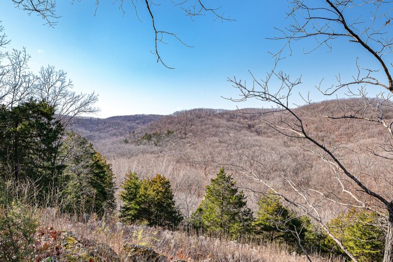
And you can find some of that in far southern IL too, down in the Shawnee National Forest area, but as a % of the state, IN has WAY more of that forested hilly terrain.

I mean, this kinda scene does exist in far southern IL, but it makes up a very tiny part of the state.


Source: https://quiltripping.com/garden-of-the-gods-illinois-in-shawnee-national-forest/


The vast majority of IL is literally giant rectangular corn fields sprawled across one of the flattest agricultural plains on the planet.
__________________
"Missing middle" housing can be a marvelous middle ground for many middle class families.

Last edited by Steely Dan; Dec 9, 2023 at 10:28 PM.
Reply With Quote
     
     
  #152  
Old Posted Feb 3, 2024, 9:09 PM
Steely Dan's Avatar
Steely Dan Steely Dan is online now
devout Pizzatarian
 
Join Date: Jul 2001
Location: Lincoln Square, Chicago
Posts: 30,510
Maybe Ohioans are more comfortably Midwestern than we previously thought?

Intrigued by their earlier finding that only 78% of Ohioans considered that they lived in "the Midwest", Emerson College polling did another poll there, and this time they found that 87% of Ohioans identified that the state is in "the Midwest", a significantly higher landslide finding.

Article: https://www.dispatch.com/story/news/state/2024/02/02/ohio-midwest-south-or-appalachia/72450466007/
__________________
"Missing middle" housing can be a marvelous middle ground for many middle class families.
Reply With Quote
     
     
  #153  
Old Posted Feb 3, 2024, 9:38 PM
Docere Docere is offline
Registered User
 
Join Date: Jul 2014
Posts: 9,121
Where else would they be? I think while the Midwest is a contested concept, it's not a matter of excluding themselves but the other half in the definition.

For example the Michigan resident wonders what they have to with the farmers out in North Dakota, while North Dakotan sees Michigan as too urban and eastern-looking to "really" be Midwestern.

Illinois and Wisconsin don't have this "issue" I don't think. Wisconsin has its rust belty east and Minnesota-like west, and most of Illinois outside Chicago might as well be Iowa.
Reply With Quote
     
     
  #154  
Old Posted Feb 3, 2024, 10:09 PM
MayDay's Avatar
MayDay MayDay is offline
Member of SSP since 1997
 
Join Date: Jul 2001
Location: Cleveland, Ohio
Posts: 7,090
Curious about the demographics and locations of the respondents, as well as the response options. Whatever the case I guarantee most would respond with something like “eh, Midwest but it’s complicated”
Reply With Quote
     
     
  #155  
Old Posted Feb 3, 2024, 10:48 PM
ColDayMan's Avatar
ColDayMan ColDayMan is offline
B!tchslapping Since 1998
 
Join Date: Jul 2001
Location: Columbus
Posts: 20,513
Quote:
Originally Posted by Steely Dan View Post
Maybe Ohioans are more comfortably Midwestern than we previously thought?

Intrigued by their earlier finding that only 78% of Ohioans considered that they lived in "the Midwest", Emerson College polling did another poll there, and this time they found that 87% of Ohioans identified that the state is in "the Midwest", a significantly higher landslide finding.

Article: https://www.dispatch.com/story/news/state/2024/02/02/ohio-midwest-south-or-appalachia/72450466007/
I'm with MayDay, dunno who they sampled in that article (it's behind a paywall for me) but I'll say Ohioans are the least likely to identify with the Midwest. This can be based on the regions of the state aka anything Southeast or Northeast of Columbus even though a majority would say they are in the Midwest.
__________________
Click the x: _ _ X _ _!
Reply With Quote
     
     
  #156  
Old Posted Feb 4, 2024, 12:25 AM
Velvet_Highground Velvet_Highground is offline
Doc Love 3.0
 
Join Date: Mar 2022
Location: Metropolitan Detroit
Posts: 714
Looking at the greater region today it’s convenient to label The Great Lakes and Upper Mississippi as the Midwest due to the economic interconnectivity and the prosperous western lake hub cities. Chicago, Milwaukee, Green Bay, Duluth & Thunder Bay are all important regional, national & international hubs that have grown up bridging the gap between navigable waterway systems.


https://www.researchgate.net/figure/Land...akes-Joint-Venture-Region_fig2_326811224

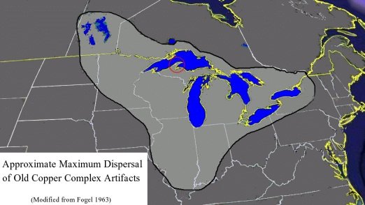
Taking a step back in time and looking at the original Great Lakes civilization the so called “Copper Culture” and their trade routes gives a glimpse at Great Lakes centered trade in albeit in a state of pre-sedentary civilization (6,500 BC - 1,000 BC). Lake Superior has the worlds largest deposit of Natural Copper or Copper appearing in the form we think of it as not a mineral which requires smelting to be useable.

Note that trade extended northwest from the Great Lakes to Lake Winnipeg and Lake Manatoba via the Rainy and Winnipeg Rivers head waters in and around The Lake of the Woods and its surrounding multitude of lakes, rivers and wetlands. The Black Swamp allowed easy canoe based trade from Lake Erie to the Maumee to Wabash & Illinois Rivers by the wetlands where Fort Wayne Indiana now is.

To the east the Ottawa River which nearly reaches Lake Huron and the chain of lakes, rivers & wetlands that surround the once secondary glacial outflow provided another route to take advantage. The Great Lakes were used in pre-Colombian trade but the hazards of navigation before the modern age on stormy waters likely played a role in where and when to travel. This is in addition to accessing tribes who were settled along these sometimes shallow or impassable waterways creating focal points and trade centers around portages.

The Potawatomi who lived in SW Oakland county had a trading hub at 14 mile and Halstead at Minnow Pond. It’s a wetlands at the headwaters of the Upper Rouge River on the edge of the Huron River watershed. I am extrapolating and scaling up to add context for my perspective. Based on what I know about local trade between watersheds which are filled with lakes, rivers & wetlands
https://www.mpm.edu/research-collections...-research/old-copper-culture/artifacts-0

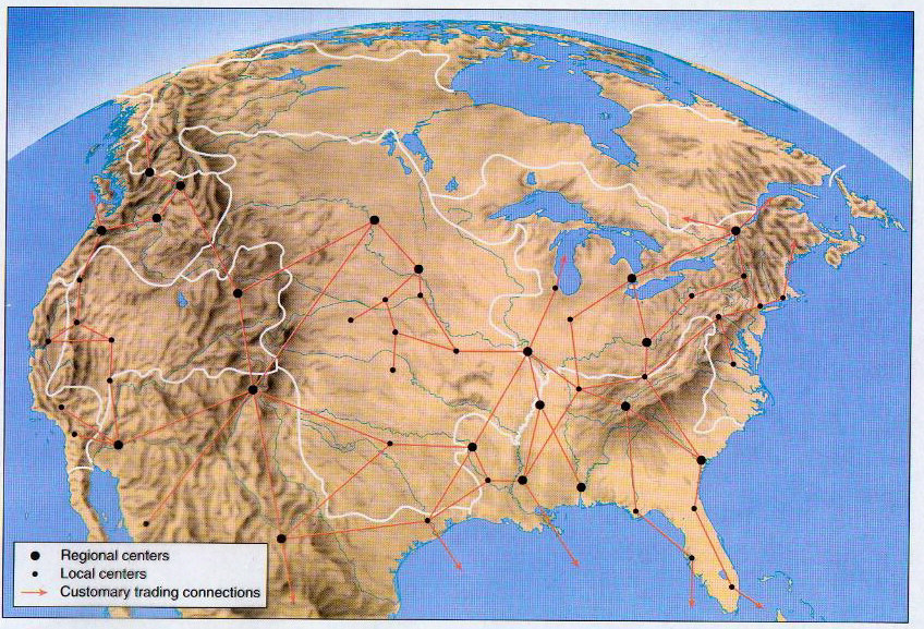
Here’s a suggested look at settled agrarian pre-Colombian North American civilization cities, trade hubs and routes. While the age of sail Europeans placed a much greater emphasis on access to deep navigable waters and ocean access getting a picture of the modern world isn’t hard when looking at this map.

http://chapter20projectgroup.weebly.com/pre-columbian-north-america.html

The French vision for North American Empire is another possibility of how North America may have been developed/settled/conquered. Just as New York City is the natural harbor on an eastern seaboard British based North America. The St Lawrence River & the Gulf of St Lawrence offers best path forward to the interior of North America. In another universe Montreal could have become the greatest city in North America though New York was always destined to be a great city full stop. The French use interior waterways following the Native American trade routes setting up forts in Manitoba with a Great Lakes alignment after losing their Hudson Bay claim in 1713.
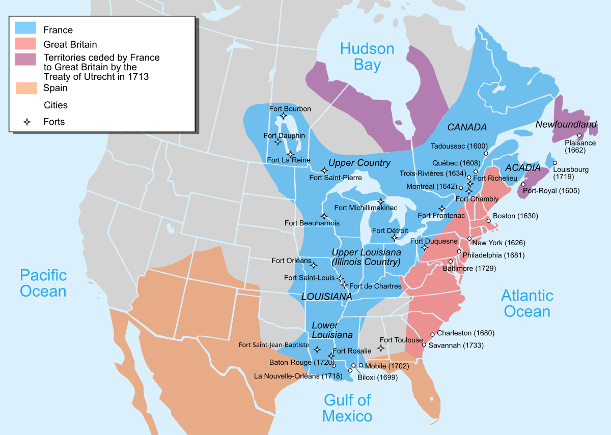

https://en.m.wikipedia.org/wiki/File:Nouvelle-France_map-en.svg

If Benedict Arnold wasn’t defeated storming the citadel of Quebec ironically due to a deserter tipping the British off that his frontal assault was a diversion to fix them in place. When he broke down the back gate instead facing an ambush in the narrow streets and getting a face full of British lead he may have brought Canada into the Continental fold. Without a hostile border and a long delay settling the Great Lakes while the Erie Canal was built the St Lawrence may have been a blue highway to the interior coast of America. It’s possible that the Great Lakes would have been settled on par with the Mississippi Valley or slightly quicker as it was more developed and had easier access to the old world.

You can’t look west at the plains without looking east to Ontario and Quebec the “Midwest” doesn’t work as a region truly unless you look at it from a North American perspective. Looking at it that way changes things Great Lakes & Upper Mississippi, Midwest, North East Central whatever. There is a border that makes Michigan and Upstate New York look like the end of the line but there aren’t two counties that have closer economic, political, military & cultural ties (with the exception of French culture going strong in Quebec while dying in Louisiana).

Definitely not apples to apples Canada spent a long time separated from the US as part of The British Empire before the post civil war rapprochement began to blur the lines again. Though that most of the population of Canada lives within 50 miles of the US border it’s hard to say with the exception of politics (Canada doesn’t have the post civil war & slavery baggage, maybe why they’re so polite) we’re pretty similar people’s. Pre 9/11 you didn’t feel the border though things have perhaps started to drift again due to that. Hopefully new high speed rail connections into Ontario from Michigan and hopefully New York will make travel easier and help bring a little Canadian perspective & cordiality into our lives.


*Map of US rivers & watersheds
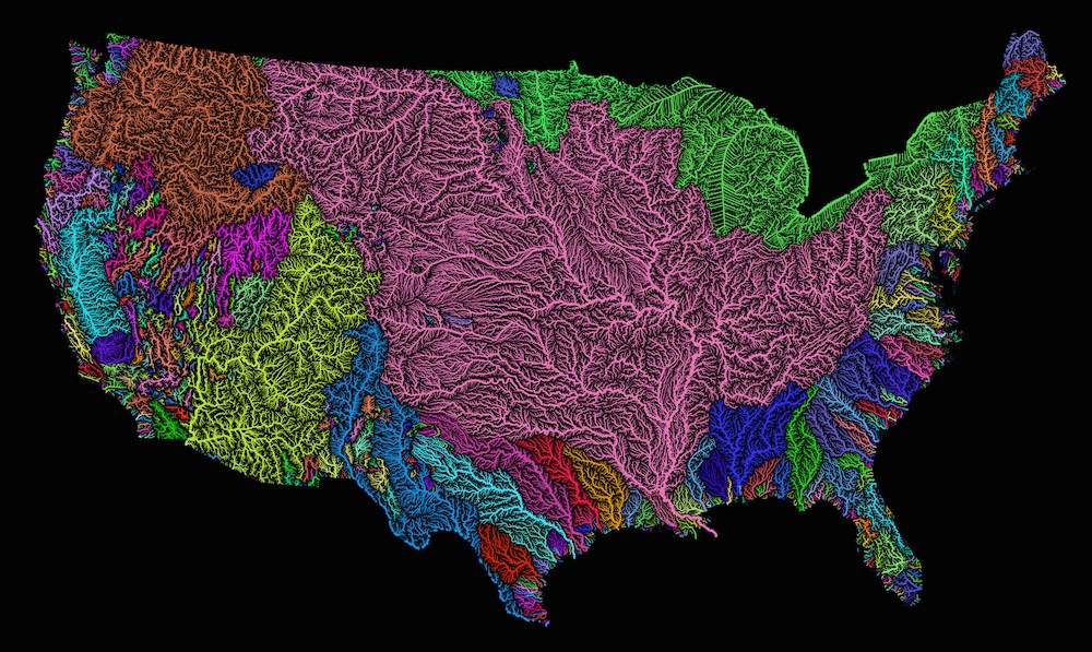
https://www.livescience.com/56751-visualization-of-united-states-rivers.html

Last edited by Velvet_Highground; Feb 4, 2024 at 12:36 AM. Reason: Canadian politeness joke-question / cool map
Reply With Quote
     
     
  #157  
Old Posted Feb 4, 2024, 2:52 AM
Docere Docere is offline
Registered User
 
Join Date: Jul 2014
Posts: 9,121
Excellent post.

Michigan and Ontario used to be more tied together. People moved and crossed borders easily in the 19th and early 20th centuries. 8% of Michigan's population was Canadian-born in 1900. In addition to geographical proximity and similarity, there were auto industry links too. Michiganders had cottages on the Canadian side of Lake Huron. The divergence really didn't occur until the rust belt to sunbelt shift in the US (and Toronto's emergence as a global city). Postwar economic policies and interventions benefitted California in the US and Ontario in Canada.
Reply With Quote
     
     
  #158  
Old Posted Feb 4, 2024, 3:08 AM
wwmiv wwmiv is offline
Registered User
 
Join Date: Sep 2009
Location: Austin -> San Antonio -> Columbia -> San Antonio -> Chicago -> Austin -> Denver -> Austin
Posts: 5,846
Quote:
Originally Posted by Velvet_Highground View Post
It is amazing to me how much this mirrors modern day reality, with major dots at roughly the locations of existing major cities.

Some obvious examples are the Pueblos / Santa Fe, Cahokia / St. Louis, and Hohokam Casa Grande / Phoenix.
__________________
Houston: 2.4m (+3.9%) + MSA suburbs: 5.4m (+12%) + CSA exurbs: 200k (+5%)
Dallas: 1.3m (+2%) / FtW: 1.0m (+10%) + suburbs: 6.4m (9%) + exurbs: 566k (+9%)
San Antonio: 1.5m (+6%) + MSA suburbs: 1.2m (+10%) + CSA exurbs: 82k (+3%)
Austin: 994k (+3%) + MSA suburbs: 1.6m (+18%)
Texas (whole): 31.29m (+7%) / Texas (balance): 8.6m (+3%)

Last edited by wwmiv; Feb 4, 2024 at 3:23 AM.
Reply With Quote
     
     
  #159  
Old Posted Feb 4, 2024, 5:05 PM
Centropolis's Avatar
Centropolis Centropolis is offline
disneypilled verhoevenist
 
Join Date: Nov 2009
Location: saint louis
Posts: 12,053
Quote:
Originally Posted by Steely Dan View Post
The vast majority of IL is literally giant rectangular corn fields sprawled across one of the flattest agricultural plains on the planet.
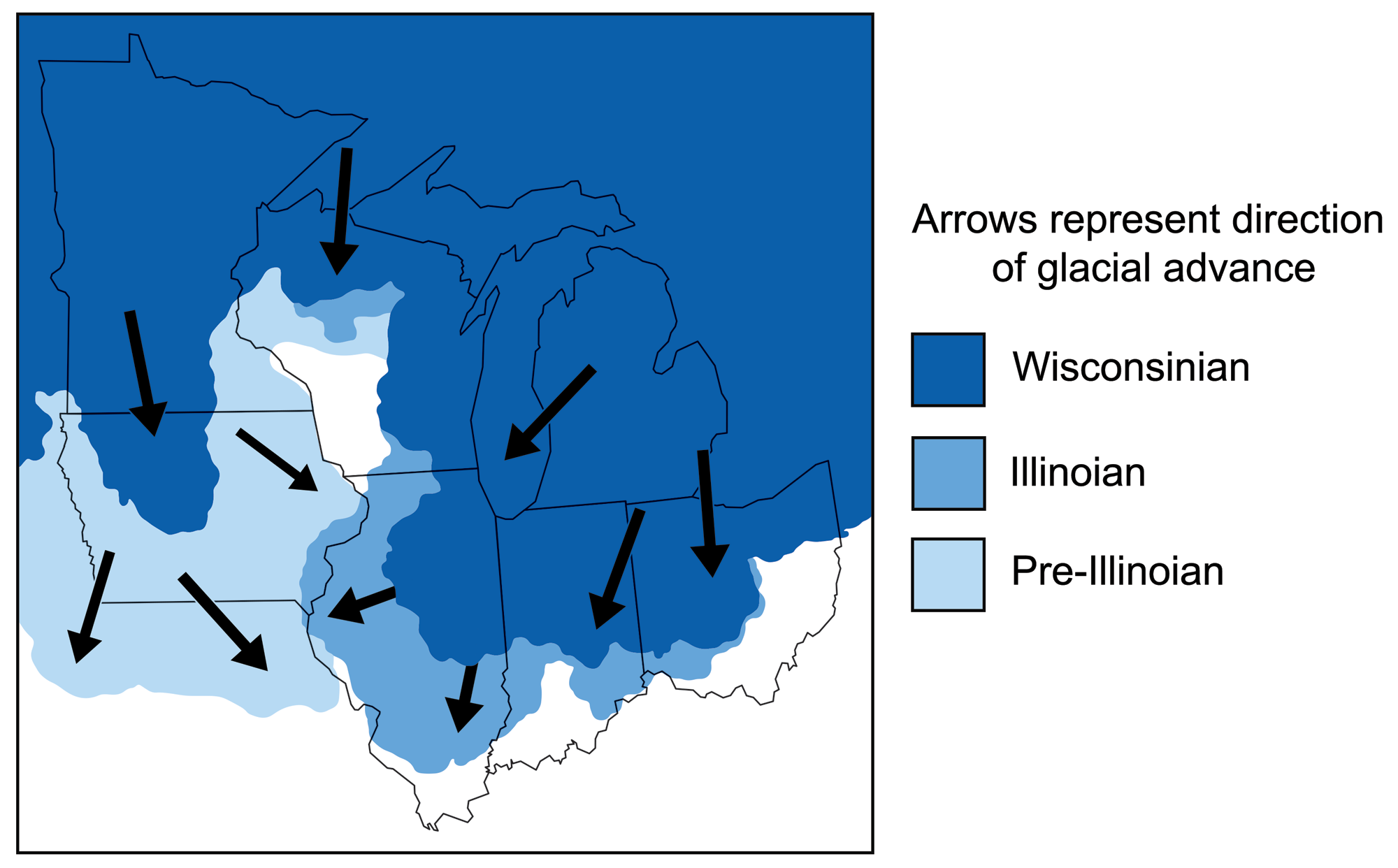
The most recent glacial maximums pushed furthest south in Illinois - great for corn, not so much for views. In St. Louis County, MO you can see where the glaciated area ends fairly dramatically in the western/southwestern suburbs right in St. Louis County along the Henry Shaw Ozark Corridor which is a long greenbelt preserving these hills, although Atlanta style hilltop sprawl is surrounding them. The landscape is just as dramatic as far southern Illinois as a result.


terrain-mag.com


earthathome.org
Reply With Quote
     
     
  #160  
Old Posted Feb 4, 2024, 8:20 PM
Centropolis's Avatar
Centropolis Centropolis is offline
disneypilled verhoevenist
 
Join Date: Nov 2009
Location: saint louis
Posts: 12,053
Quote:
Originally Posted by wwmiv View Post
It is amazing to me how much this mirrors modern day reality, with major dots at roughly the locations of existing major cities.

Some obvious examples are the Pueblos / Santa Fe, Cahokia / St. Louis, and Hohokam Casa Grande / Phoenix.
theres also old maps showing the overland trail when st. louis was a (french speaking) spanish possession going to santa fe which is cool. i’d like to get one of these maps framed. most of the maps are recreations of american maps.
Reply With Quote
     
     
This discussion thread continues

Use the page links to the lower-right to go to the next page for additional posts
 
 
Reply

Go Back   SkyscraperPage Forum > Discussion Forums > City Discussions
Forum Jump


Forum Jump


All times are GMT. The time now is 12:56 AM.


Powered by vBulletin® Version 3.8.7
Copyright ©2000 - 2026, vBulletin Solutions, Inc.