New subdivision developments


Well that's because people see forests as pretty and useful and must be protected against "teh ev0l deVel0perz!" even though farmland is much more important. I also get a feeling that some people are putting too much faith into the hopeful success of those stacked farm towers so to speak.

As part of an urban fabric, I find some natural area much more enhancing that farmland. I grew up near an urban forest and it was the highlight of my childhood. The nearby farmers fields contributed absolutely nothing.

Of course, the farmers fields are still there and the urban forest was developed with a few McMansions.
 
some background info...

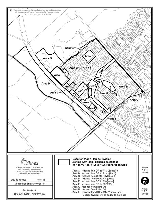
this is the subdivision in question (OPA/Zoning/Draft Plan staff report)

image014.jpg


a few overlays are shown here


the south part of it near Kizell Pond is already under development by Richcraft and Urbandale
kp-aerialimage.jpg

http://mykanatalakes.com/index.html
kanatatowns.jpg

http://richcraft.com/kanatatowns-aerial.htm


Google Streetview offers a nice view of the pristine natural setting these homes will be built in
(to be fair I think that's actually the Kanata North Catholic Elementary school site ;) )


there's also the Special Study Area (staff report) approved in 2004.... basically the area between the above subdivision and Terry Fox Drive. It is supposed to look something like this, but there was OMB hearing so it may be slightly different.

ssa-all.jpg

source of image http://kanata-forum.ca/special_study.htm


Regional/Uniform has submitted an application for part of these lands. They note in their planning application that they want to work with the existing terrain as much as possible and minimize blasting.


Richardson Ridge (Regional Group + Uniform)
Future Terry Fox @ Richardson Side Road

richardsonridge.jpg
 
Last edited:
As part of an urban fabric, I find some natural area much more enhancing that farmland. I grew up near an urban forest and it was the highlight of my childhood. The nearby farmers fields contributed absolutely nothing.

Of course, the farmers fields are still there and the urban forest was developed with a few McMansions.

Don't get me wrong, I much prefer forest to farmland, but farmland is incredibly useful and often needed. We do need to be capable of feeding ourselves after all. That said, I still feel that we should put high density in some parts of the Central Experimental Farm, and convert the rest into botanical gardens and expanding the Arboretum, truly making it like Central Park, but for Ottawa. We should also put medium to high-density in the parts of the greenbelt that are nothing more than fields and NCC-sponsored farms.
 
Don't get me wrong, I much prefer forest to farmland, but farmland is incredibly useful and often needed. We do need to be capable of feeding ourselves after all. That said, I still feel that we should put high density in some parts of the Central Experimental Farm, and convert the rest into botanical gardens and expanding the Arboretum, truly making it like Central Park, but for Ottawa. We should also put medium to high-density in the parts of the greenbelt that are nothing more than fields and NCC-sponsored farms.

You're preaching to the converted on the greenbelt, but I think the CEF should stay undeveloped, except for institutional uses like a museum or aquarium or something. I'd love to see it become like Central Park.
 
11th Hour Meeting On South March Highlands

Looks like Kanata North Coun. Marianne Wilkinson and the city managed to organize a public meeting before bulldozers start clearing way for a residential development in a Kanata forest.

The public meeting is scheduled for Thursday, 7 p.m., at John G. Mlacak Centre on Campeau Dr.

KNL Developments is ready to build a new subdivision in South March Highlands, which is home to threatened species of animals and trees and said to be the city’s richest ecological area. The developer has pretty much received the green light to begin the work and has indicated to Wilkinson it would begin this month, possibly as early as Monday. There is a complex history of this land going back decades. The land was designated for development long before KNL bought it in 2002.

At city council tomorrow, Wilkinson intends to have a motion ready that, if passed, could delay the clear-cutting. There seems to be some disagreement between KNL and the city whether or not the developer has the approval to begin building

...

article continued at The Sun's website http://blogs.canoe.ca/cityhall/general/11th-hour-meeting-on-south-march-highlands/

Councillor Wilkinson has uploaded the 2006 OMB decision, subdivision conditions, and tree preservation plan for anyone interested
http://www.mariannewilkinson.com/content.php?doc=147
 
11th Hour Meeting On South March Highlands


article continued at The Sun's website http://blogs.canoe.ca/cityhall/general/11th-hour-meeting-on-south-march-highlands/

Councillor Wilkinson has uploaded the 2006 OMB decision, subdivision conditions, and tree preservation plan for anyone interested
http://www.mariannewilkinson.com/content.php?doc=147

Thanks for the info...if you look at the OMB decision on the Councillors website, you can see that she participated as an agent/counsel for the local community association. I believe she has appeared as an expert witness on behalf of developers in the past in Ottawa before she was a City Councillor.
 
Councillor Wilkinson has uploaded the 2006 OMB decision, subdivision conditions, and tree preservation plan for anyone interested
http://www.mariannewilkinson.com/content.php?doc=147

She mentions there that the subject lands are valued at some $400M. Doing a little subtraction and addition from the numbers presented in the OMB report that she has posted, I get a total of about 160 hectares of land to be developed, which, looking at it on Google Earth, looks about right. So that means a value of about $2.5M/hectare, or $1M/acre.

Is it just me or does that not seem just a tad high for as yet unserviced land? I recall reading an article in the Citizen from 2005 by Mohammed Adam (iirc) in the run-up to the N-S LRT project that serviced land within the urban boundary was about $500,000/acre and that unserviced land was about a tenth of that, give or take, depending on where it was.

I think the $400M figure refers to the estimated final assessment value of this land once it is developed and not to its pre-development value. Using an arbitrary figure of $65,000/acre for this unserviced land, I get a total land value of about $25M.

Not that I think buying this land is a particularly good idea, but if we really wanted to we could do it.


Interestingly, in the UK land development has essentially been nationalized, a fact that basically removes the incentive to speculate on undeveloped land (except as a scam, of which apparently Canadians are semi-frequent victims). Governments essentially expropriate farmland or other undeveloped land at its economic value (i.e. its value as farmland, woodlot, etc., ignoring its locational or development value) and then direct its development, which varies from council to council. If a similar planning regime existed here, the City could buy up land at no more than a few thousand dollars per acre (possibly even less on the Canadian Shield) and proceed to service and develop it as it saw fit...
 
Interestingly, in the UK land development has essentially been nationalized, a fact that basically removes the incentive to speculate on undeveloped land (except as a scam, of which apparently Canadians are semi-frequent victims). Governments essentially expropriate farmland or other undeveloped land at its economic value (i.e. its value as farmland, woodlot, etc., ignoring its locational or development value) and then direct its development, which varies from council to council. If a similar planning regime existed here, the City could buy up land at no more than a few thousand dollars per acre (possibly even less on the Canadian Shield) and proceed to service and develop it as it saw fit...

We should definitely be doing the same.
 
Council votes to delay clear-cutting
Developer says conditions met for South March Highlands project
http://www.ottawacitizen.com/techno...cutting/3279234/story.html?cid=megadrop_story
BY KATE JAIMET, THE OTTAWA CITIZEN JULY 14, 2010 11:02 PM

City council passed a motion Wednesday that could delay the planned clear-cutting of 20 hectares of pristine forest in the South March Highlands.

The motion would stop the developer, KNL Development Limited, from cutting down trees in the area north of Kanata’s Beaver Pond until it has met certain conditions, including a city-approved tree planting and conservation plan.

KNL, a partnership between development companies Urbandale and Richcraft, has said it plans to begin clear-cutting the forest Monday. Before the meeting, the company sent a letter to city councillors saying it believed it had “followed all city policies and requirements for the draft plan approval in order to proceed with the development.”

The letter said the company understood the concerns of nearby residents, but it was just living up to the terms of an agreement made 28 years ago. It’s building on land that was approved for development when other property — including Trillium Woods — was preserved as natural area, and, now that it has met all the conditions, KNL plans to go ahead.

“The developer says their tree-preservation plan has been approved. City staff says it has not been approved,” Kanata North Councillor Marianne Wilkinson said. “I take the direction that city staff are the ones to tell us if something has been approved or not.”

Besides the tree conservation plan, the motion mentions four other plans that KNL must develop and have approved by the city before it can begin cutting trees:
-a communications strategy acceptable to the city’s director of planning;
-an archeological plan;
-a natural features and vegetation preservation plan; and
-a city-approved storm water management plan.

The required plans are among a list of 89 conditions that were agreed upon several years ago by KNL and the city and have been upheld by the Ontario Municipal Board.

Wilkinson said she was concerned that, if the city was lax in enforcing the conditions, it could face a lawsuit from citizens opposing the development, which would destroy part of the ecologically significant South March Highlands.

“I know the trees will come down eventually. I’m not trying to stop that.… I just want to make sure it’s squeaky-clean,” Wilkinson said. “Hopefully, if they look at it some more, they can find some place where they can save some trees. I don’t know.”

Mayor Larry O’Brien expressed concern that KNL could undertake legal action if the city delayed its development plans. In response to the mayor’s comments, city solicitor Tim Marc informed council that KNL filed documents with the Ontario Municipal Board on Wednesday morning, asking for clarification of the 89 conditions.

In accordance with the motion, city staff will send a letter to KNL saying that, until the conditions are met and approved by the city, “no clear cutting or other site modification can occur in the South March Highlands.”

As well, city staff are directed “to pursue all legal means, including an injunction, in the event that KNL fails to comply.”

Council also passed a motion asking staff to negotiate a land-exchange with KNL that would allow the city to retain a 20-metre-wide, wooded corridor through the KNL development lands, linking Beaver Pond to Trillium Woods. The specific land-exchange would have to be approved by council after the staff negotiations.

City staff and developers will also face questioning from the community tonight at a public meeting.

Councillors Jan Harder and Peter Hume supported the motion, but warned it would not change the fact that trees would eventually be cut and the area would be developed.

Councillors Diane Holmes and Alex Cullen said the city should go further to try to save the forest. “If we were interested in stopping development, we would be expropriating these lands and putting them to public use, and that would be what I think the public wants,” Cullen said.

© Copyright (c) The Ottawa Citizen
 
Last edited:
Council v
“I know the trees will come down eventually. I’m not trying to stop that.… I just want to make sure it’s squeaky-clean,” Wilkinson said. “Hopefully, if they look at it some more, they can find some place where they can save some trees. I don’t know.”

Councillors Diane Holmes and Alex Cullen said the city should go further to try to save the forest. “If we were interested in stopping development, we would be expropriating these lands and putting them to public use, and that would be what I think the public wants,” Cullen said.


Does anybody out there have an image of what a squeaky clean tree looks like when it is being clear cut. Honestly, Wilkinson has really been stretching on this matter (hmm, do you think it is election year) when the main damage to let these lands be developed occurred in approvals granted in 1982 IIRC.

Under what methodology do Holmes and Cullen think that they can expropriate these lands.....doesn't the Kanata Lakes neighbourhood already have a huge % of land already dedicated at a greater % level than what the Planning Act mandates.

This is going to get ugly before it gets better.

Yep, and this particular part of Kanata Lakes got a modified OPA, draft plan, and rezoning all approved by the City in 2004 (confirmed at OMB in 2006). There's been plenty of opposition to this development in the past, so it's not like this is happening out of the blue... but it's kind of late to wait until they have (or allegedly almost have) fulfilled all of their conditions and are ready to start construction to talk about buying or expropriating the land. At the very least, this campaign should have started 4 years ago once they got their draft plan and rezoning approval and development of these particular environmental lands was inevitable.

To be fair the "40% open space" includes things like a private golf course, stormwater management, hydro corridors, conservation woodlots, etc.... which wouldn't be included in regular parkland dedication.

I wonder what will happen on-site on Monday...
 
Last edited:
To be fair the "40% open space" includes things like a private golf course, stormwater management, hydro corridors, conservation woodlots, etc.... which wouldn't be included in regular parkland dedication.

I wonder what will happen on-site on Monday...

Ugh, a golf course...one of my most despised land uses.

I gather the 40% is really 60% not built upon.

This pre-election posturing by Wilkinson is all just tilting at windmills in my mind.
 
the Owner has filed with the City a residential draft plan of subdivision and implementing zoning by-law amendment for review. The land known as Minto's Mahogany Community Phase 1 is approximately 25.3 hectares in size. The Owner proposes to develop on full municipal services a total of 210 residential units; which includes a mix of housing types with varying lot sizes, parkland and open space. Access will be provided via a collector road off of Manotick Main Street which feeds a number of local roads and lanes. A secondary access is also provided off of Century Road.

http://app01.ottawa.ca/postingplans/appDetails.jsf?lang=en&appId=__7OF8H1
 
City throws up new hurdle to Kanata growth
http://www.ottawacitizen.com/City+throws+hurdle+Kanata+growth/3301573/story.html
Letter tells developers to add 10-metre buffer to housing plan

BY KATE JAIMET, THE OTTAWA CITIZEN JULY 20, 2010


A planned housing development north of Kanata’s Beaver Pond can’t go ahead until the development company agrees to preserve a buffer zone around natural areas and inventories the endangered species on the site, according to a letter sent to the developers Friday by the city of Ottawa.

But the director of planning for the “KNL” development says the buffer zone is already there, and that — apart from butternut trees — there are no endangered species living in the area of the future housing development.

“We’ve had a very respected biologist out to the site on three dates, looking for Blanding’s turtles and ginseng … and he did not see them,” said Mary Jarvis, director of planning and development with Urbandale (which is working with developer Richcraft on the KNL project). “We don’t think there are any endangered species in there.”

The letter represents the latest hold-up in the plans to blast and raze 20 hectares of mature forest inside the arc of the new Terry Fox Drive extension, in order to build Phase 9 of its Kanata Lakes housing subdivision. Two subsequent phases of the development will bring to 182 hectares the total amount of forest to be cut down.

The land is part of a

566-hectare parcel in Kanata that has been designated for development since 1983, subject to an agreement that 40 per cent of the total land be kept as open space.

But a group of citizens, spearheaded by Kanata resident Steve Hulaj, is trying to stop the latest phase of development, arguing the woodland should be preserved.

In the letter, Michael Wildman, the city’s manager of development review, says KNL should preserve an additional 10-metre-wide buffer alongside all lands identified as “Natural Environment Areas.”

In the case of the current subdivision, this would apply to the north side of Beaver Pond park.

But Jarvis pointed to a draft plan of the subdivision, which shows a 17-hectare buffer is already planned between the Beaver Pond park and the nearest housing units, as part of the agreement to keep 40 per cent of land open space.

“If they’re asking for additional lands, that’s contrary to the 40-per-cent agreement, and they (the city) would have to buy it,” she said.

The letter also asks the company to identify groupings of trees, located within the future subdivision, that could be protected. But Jarvis said that it is nearly impossible to protect trees on individual development lots, due to the hilly terrain and the need to blast the site in order to make it level. She said, however, that some trees might be kept in the back yards of lots adjacent to the natural environment areas.

The letter also asks KNL to prepare an inventory of species at risk on the site, focusing especially on American ginseng and Blanding’s turtle.

(Endangered butternut trees do exist on the site, and the company is working with the Ministry of Natural Resources to obtain cutting permits and develop a mitigation plan to minimize the damage to them.)

“If species at risk are identified on the site, or if they are likely to occur on site at some point during their life cycle, then the plan must include appropriate mitigation measures for their protection,” the letter says.

Although Jarvis said there are no Blanding’s turtles on the site, the animals are known to roam widely, and the environmental assessment report prepared for the nearby Terry Fox Drive extension identified all wetland and adjacent forest in the South March Highlands as possible Blanding’s turtle habitat.

Rick Watchorn, the area supervisor for the MNR in Kemptville, said the MNR is aware of the situation but he couldn’t speak about it until today.

© Copyright (c) The Ottawa Citizen
 
The Edelweiss Speedway just outside Cantley is doomed because of NIMBYS (once again) and will be replaced sadly apparently by another bland residential area. More sprawl :yuck:

With that leaves only two nearby raceways at Calabogie and the Capital City Speedway, but none of those host notable races (there wasn't even notable races at Edelweiss anyways), not even Nascar Canada.


Back
Top