HomeDiagramsDatabaseMapsForum About
     

Go Back   SkyscraperPage Forum > Regional Sections > Canada > Ontario > Ottawa-Gatineau > Transportation


Reply

 
Thread Tools Display Modes
     
     
  #1  
Old Posted Dec 3, 2025, 8:43 PM
J.OT13's Avatar
J.OT13 J.OT13 is offline
Moderator
 
Join Date: Mar 2012
Location: Ottawa
Posts: 29,075
Kettle Island Bridge | Planning Stage

Public participation report from the NCC: https://ncc-ccn.gc.ca/projects/eastern-b...sid=8ba2c511-01cb-f011-80f5-0050568ece72

EDIT from thread creation, September 2, 2026.

This thread has been created for the Kettle Island Bridge that is currently in development by the Federal Government.

For discussions about potential new bridges that are not in planning or being discussed by Government, please use the Interprovincial bridge crossing discussion: https://skyscraperpage.com/forum/showthread.php?t=144112&page=95
For discussions about the Alexandra Bridge replacement, please use the Alexandra Bridge replacement thread: https://skyscraperpage.com/forum/showthread.php?t=238717&page=27
For discussions about the King Edward Tunnel Jim Watson briefly proposed, please use the Sandy Hill Truck Tunnel thread: https://skyscraperpage.com/forum/showthread.php?t=212774&page=60

Last edited by J.OT13; Sep 2, 2026 at 4:27 PM.
Reply With Quote
     
     
  #2  
Old Posted Dec 4, 2025, 11:02 PM
rocketphish's Avatar
rocketphish rocketphish is offline
Planet Ottawa and beyond
 
Join Date: Feb 2009
Location: Greater Ottawa
Posts: 14,669
Getting trucks out of downtown tops list of benefits for Kettle Island bridge, NCC report finds
The survey results came from public consultation into the latest iteration of the plans for a potential sixth span linking Ottawa and Gatineau.

By Ben Andrews, Ottawa Citizen
Published Dec 04, 2025 | Last updated 17 minutes ago


Limiting truck traffic in the downtown core is viewed by residents on both sides of the Ottawa River as the top potential benefit of a proposed east-end bridge, a new National Capital Commission report has found.

Community consultation is underway on plans to build a sixth bridge across the river linking Ottawa’s Aviation Parkway to Gatineau’s Montée Paiement across Kettle Island.

Plans for a bridge in that location have been drawn up, shelved and dusted off again since the 1990s. The current attempt at getting the project off the ground was included in the federal government’s 2024 fall economic statement.

On Thursday, the NCC released a report summarizing the first round of public consultation into the latest iteration of the bridge plans.

Of 5,113 responses to an online survey, 38.5 per cent listed reducing truck traffic as the most important potential benefit. That issue ranked at the top of the list for residents in both Ontario and Quebec by a wide margin.

Reducing commute times and providing better options for public transit were a distant second and third.

Meanwhile, the top concern respondents raised about the project was the potential for traffic impacts on nearby neighbourhoods.

Results highlight longstanding divide

Building a new interprovincial bridge over Kettle Island has been a contentious issue for decades.

In 2012, politicians and residents in east-end neighbourhoods successfully scuttled an NCC proposal to revive the bridge proposal.

Then, in 2019, the federal government asked the NCC to resurrect the idea. Geotechnical studies were conducted in 2022.

Since then, the government has contracted technical advisors for the project.

Area MPs are divided on whether to forge ahead, with Ottawa-Vanier-Gloucester MP Mona Fortier opposing the current proposal, and Gatineau MP Steven MacKinnon vocally backing it. Community groups are likewise divided, with some praising the bridge’s potential to limit truck traffic downtown and others concerned that traffic would merely be diverted elsewhere.

As the latest survey shows, trucks are top of mind for many residents, though views are mixed among politicians as to whether another bridge is the best way to achieve that end.

According to an NCC study, about 3,500 trucks cross the Ottawa River each day, with 72 per cent of them taking the Macdonald-Cartier Bridge leading into Lowertown Ottawa.

The latest NCC report included demographic information on survey respondents. Young and racialized respondents were underrepresented, and the survey featured “strong participation” from middle- to upper-income households.

The next round of public input, which will include an opportunity for comment on early design concepts for the bridge, is scheduled for 2026.

https://ottawacitizen.com/news/trucks-downtown-ottawa-gatineau-bridge-ncc

Reply With Quote
     
     
  #3  
Old Posted May 25, 2026, 2:46 PM
J.OT13's Avatar
J.OT13 J.OT13 is offline
Moderator
 
Join Date: Mar 2012
Location: Ottawa
Posts: 29,075
Le sixième pont au cœur d’une joute politique à Gatineau
Par Mathieu Bélanger, Le Droit
24 mai 2026 à 04h05


Gatineau Ensemble poursuit ses efforts afin de forcer le conseil municipal à prendre rapidement une position formelle sur le projet de pont de l’Île Kettle, mais la démarche pourrait s’annoncer plus compliquée qu’anticipé par le parti d’opposition.

Les membres de la commission des transports sont venus mettre un peu de sable dans l’engrenage, jeudi, en adoptant à l’unanimité une recommandation qui sera acheminée au conseil municipal en juin. Si elle est adoptée par une majorité d’élus, cela pourrait ultimement prolonger l’exercice de positionnement auquel le conseil est convié par Gatineau Ensemble.

Alors que l’opposition souhaite simplement obtenir une position d’appui du conseil envers le projet fédéral, la commission des transports, suggère aux élus une séquence différente. Les membres de la commission proposent d’abord d’étudier le dossier du pont dans l’est afin d’être en mesure de faire une recommandation à l’intention des membres du conseil municipal. Ils jugent que cela s’inscrit clairement dans le mandat de la commission.

Pour ce faire, le conseil devrait accepter d’ajouter le dossier du pont au plan de travail de la commission des transports. Le plan pour 2026 a cependant déjà été adopté, ce qui pourrait repousser l’exercice à 2027. Une fois l’accord du conseil obtenu, la présidente de la commission, Catherine Craig-St-Louis, souhaiterait interpeller la Commission de la capitale nationale (CCN) afin que ses représentants viennent faire une présentation des données et des différentes études menées à ce jour entourant le projet de pont de l’île Kettle.

La commission demande aussi à obtenir, pour nourrir sa réflexion, les analyses faites par la Ville [si de telles analyses existent] concernant les impacts sur la circulation, les plans d’aménagement, ainsi que les coûts qu’un tel projet pourrait engendrer pour la municipalité.

«Notre recommandation au conseil pour un tel exercice va cheminer en parallèle de celle de Gatineau Ensemble, a noté Mme Craig-St-Louis. On ne croit pas que le conseil devrait se prononcer sur un projet pour lequel il n’a pas eu un portrait plus complet.»

Questionnée cette semaine quant à sa position sur le pont dans l’est, la mairesse de Gatineau, Maude Marquis-Bissonnette, a évité de répondre directement. Elle a rappelé que les démarches de Gatineau Ensemble allaient nécessairement engendrer des discussions sur le sujet au cours des prochaines semaines. La mairesse a ajouté qu’il n’y avait pour l’instant «rien de nouveau dans ce projet fédéral».

Le ministre fédéral des Transports et député de Gatineau, Steven MacKinnon, a pour sa part affirmé à Radio-Canada, plus tôt cette semaine, que le pont dans l’est «c’est un chantier, ce n’est plus un projet à l’étude, les études sont faites et elles sont disponibles».

https://www.ledroit.com/actualites/actua...e-a-gatineau-A7ATIWDTURE27MVHQJYUQTUEXY/
Reply With Quote
     
     
  #4  
Old Posted May 25, 2026, 3:50 PM
Uhuniau Uhuniau is offline
Registered User
 
Join Date: Jan 2010
Posts: 9,087
Quote:
Originally Posted by cprail View Post
Amen to that. Comfort is almost never even mentioned. To be honest that's 100% why I drive downtown from Aylmer. Bumpy, vibrating, winding, fogged up/dirty/covered in dots up windows, noisy buses make me want to puke (literally). I can handle it for 15 minutes, not 40. People who want to fix transit with buses don't ride buses.
Am I imagining things, or are things even bumpier than usual this spring?
__________________
___
Enjoy my taxes, Orleans (and Kanata?).
Reply With Quote
     
     
  #5  
Old Posted Jun 23, 2026, 10:40 PM
rocketphish's Avatar
rocketphish rocketphish is offline
Planet Ottawa and beyond
 
Join Date: Feb 2009
Location: Greater Ottawa
Posts: 14,669
NCC approves design principles for 6th bridge over Ottawa River
NCC aiming for final design by 2029, opening by 2034

Matthew Kupfer · CBC News
Posted: Jun 23, 2026 4:03 PM EDT | Last Updated: 2 hours ago


The National Capital Commission (NCC) has approved planning and design principles for a sixth interprovincial link between Ottawa and Gatineau, but construction remains years away.

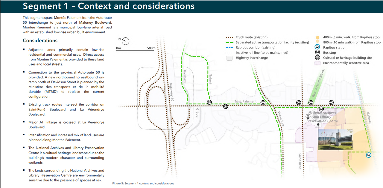
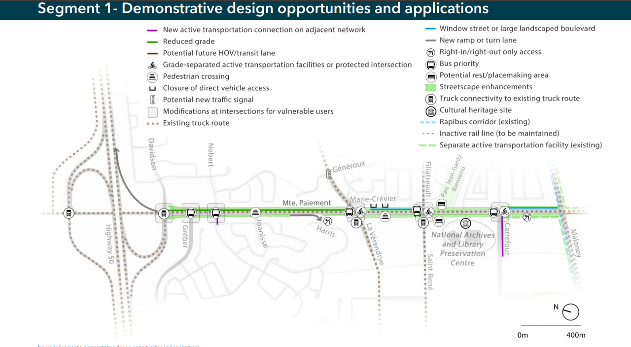
The project would connect a corridor from Highway 50 and Montée Paiement in Gatineau, Que., to the Aviation Parkway in Ottawa and eventually Highway 417, with the aim of diverting truck traffic from Ottawa's downtown core.

The NCC's board of directors received an update on the project and approved the planning and design principles document on Tuesday.

NCC staff divided the 11-kilometre corridor into five segments:
  1. Montée Paiement between Highway 50 and Maloney Boulevard.
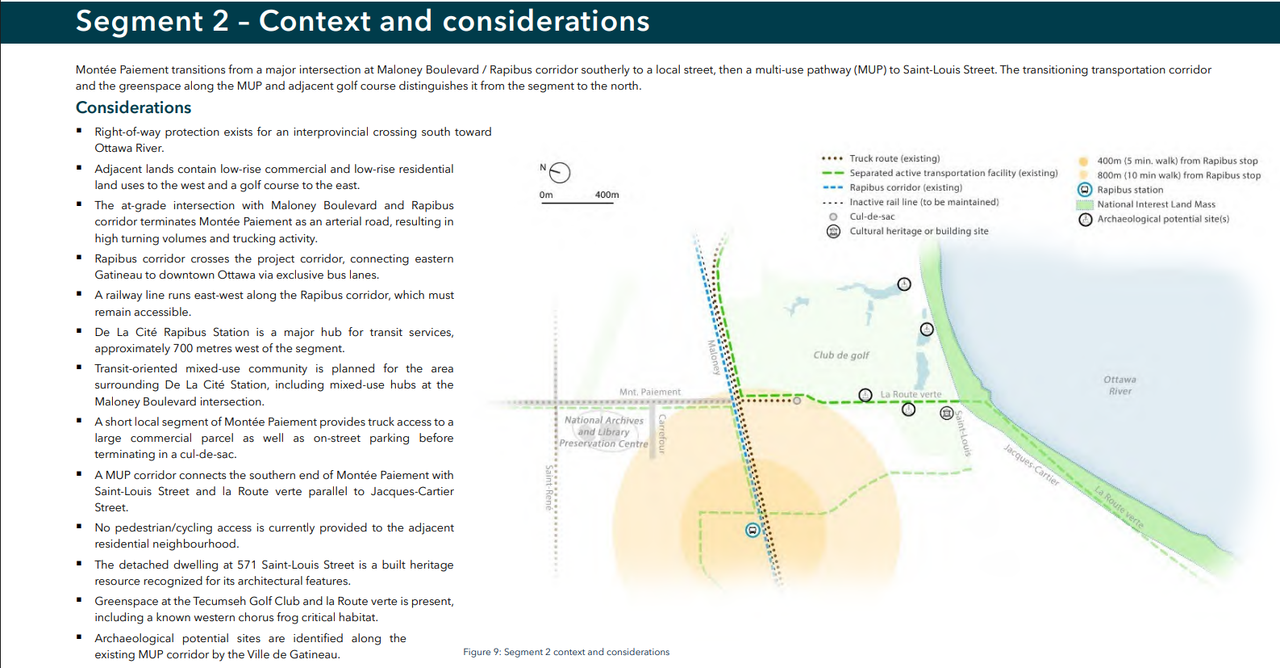
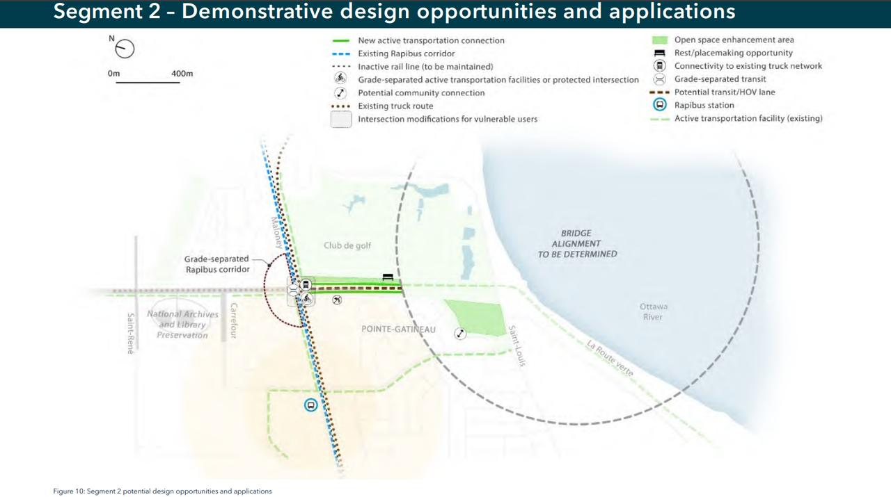
  2. Montée Paiement south of Maloney Boulevard to the shore of the Ottawa River.
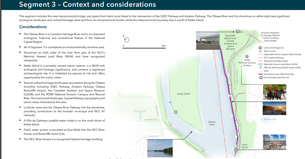
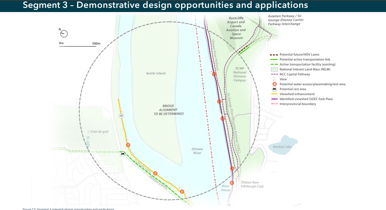
  3. The bridge spanning the Ottawa River with an alignment still to be determined.
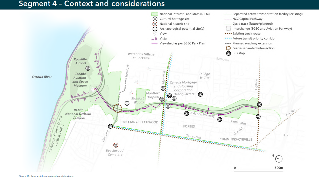
  4. Aviation Parkway from the Sir George-Étienne Cartier Parkway to the north of Ogilvie Road.
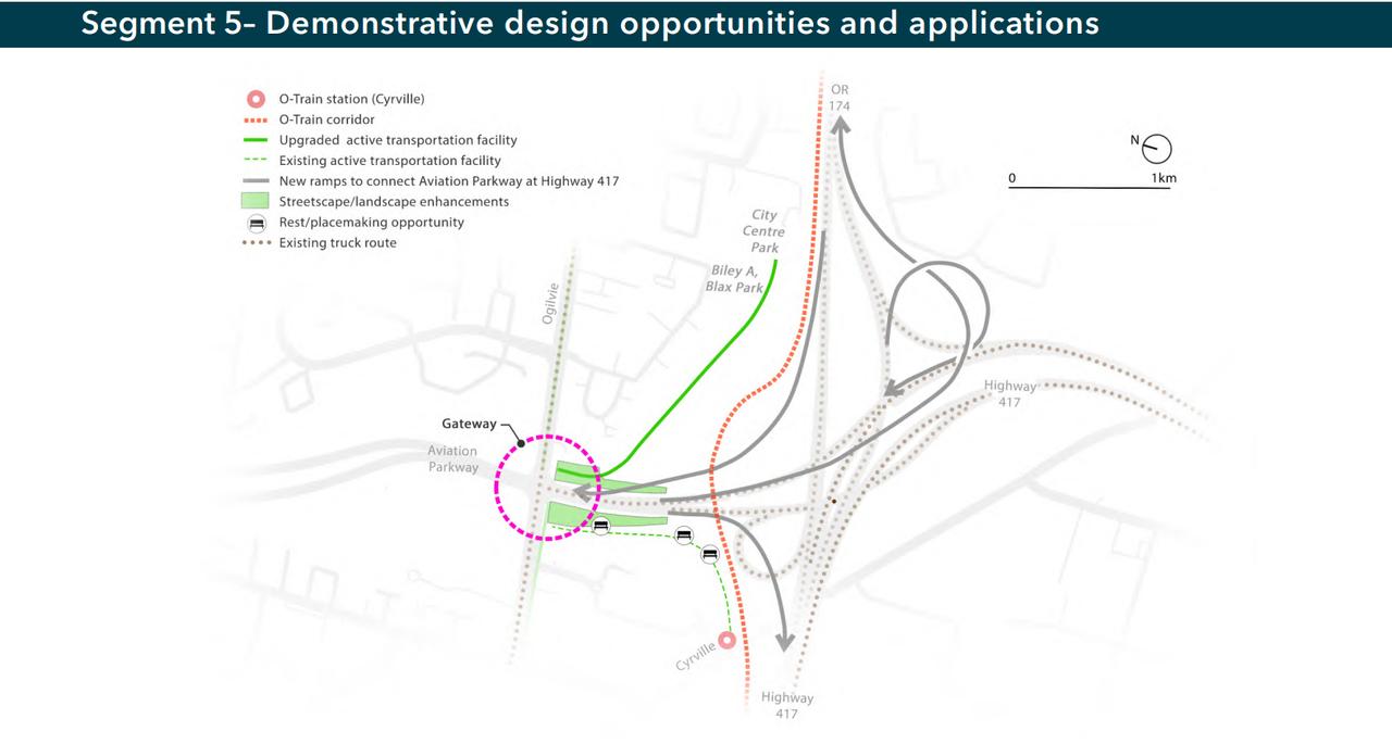
  5. Ogilvie Road to the interchange with highway 417 and 174.

The planning and design document sketches out a variety of options for dividing the right of way between general traffic, transit, cycling and pedestrian uses.

Staff said the different segments reflect the local geography, planning priorities and road uses in those areas.

The staff presentation also noted key approval milestones for achieving a 2034 opening, notably approving the corridor and part of the schematic design next year, with the final design by 2029.

Public Services and Procurement Canada is the lead agency on the project.


https://www.cbc.ca/news/canada/ottawa/nc...r-6th-bridge-over-ottawa-river-9.7246197
Reply With Quote
     
     
  #6  
Old Posted Jun 23, 2026, 11:05 PM
rocketphish's Avatar
rocketphish rocketphish is offline
Planet Ottawa and beyond
 
Join Date: Feb 2009
Location: Greater Ottawa
Posts: 14,669
Reply With Quote
     
     
  #7  
Old Posted Jun 24, 2026, 12:42 AM
dougvdh dougvdh is offline
Registered User
 
Join Date: Jun 2017
Posts: 373
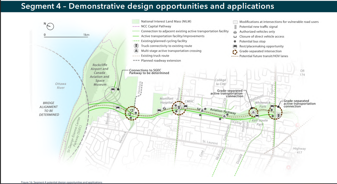
I guess we shouldn't be surprised that Hemlock/Beechwood and the Rockcliffe Parkway get protected from any additional traffic impacts by cutting off access.

Also looks like they're struggling to figure out the crossing align in such a way that it doesn't adversely impact the airport operations. Just a big vague oval. Not sure how they are going to pull that without push way far west so that either the new road can go under an elevated SGEC or that the new road can cross above SGEC. Either way, there's also an intersecting aircraft approach to deal with.

Also, there's some vague promise of a grade separated pedestrian crossing down at Ken Steeles park (where there's no no current cross and no real desire line), but not at la Cite where there is actually a lot of crossing pedestrian and cycling traffic.

Finally, traffic on the 417 between the split and downtown should be really fun for everyone once this opens - there's a lot of different things dumping all together in the same spot (plus toss in Tewin and a few 10 of thousands of new units in Orleans south.) We might finally get big city traffic jambs.
Reply With Quote
     
     
  #8  
Old Posted Jun 24, 2026, 8:51 AM
YOWetal YOWetal is offline
Registered User
 
Join Date: Oct 2006
Posts: 7,742
Quote:
Originally Posted by dougvdh View Post
I guess we shouldn't be surprised that Hemlock/Beechwood and the Rockcliffe Parkway get protected from any additional traffic impacts by cutting off access.
This makes some sense but does limit the usefulness a lot. Meanwhile are the Feds now paying for this and it's going ahead?
Reply With Quote
     
     
  #9  
Old Posted Jun 24, 2026, 9:22 AM
acottawa acottawa is offline
Registered User
 
Join Date: Aug 2009
Posts: 18,912
Quote:
Originally Posted by YOWetal View Post
This makes some sense but does limit the usefulness a lot.
Hemlock/Beechwood and the Parkway are well served by existing bridges.
Reply With Quote
     
     
  #10  
Old Posted Jun 24, 2026, 10:34 AM
YOWetal YOWetal is offline
Registered User
 
Join Date: Oct 2006
Posts: 7,742
Quote:
Originally Posted by acottawa View Post
Hemlock/Beechwood and the Parkway are well served by existing bridges.
Gatineau to RCMP, GAC, Byward Market,Vanier would all benefit from not having to go all the way south to the 417. The problem isn't the bridge it's the 50 into Gatineau so avoiding that would be a key benefit. The sprawl this bridge will encourage might make that point worse in fact.
Reply With Quote
     
     
  #11  
Old Posted Jun 24, 2026, 12:26 PM
kwoldtimer kwoldtimer is offline
Registered User
 
Join Date: Jan 2008
Location: La vraie capitale
Posts: 26,239
Quote:
Originally Posted by YOWetal View Post
This makes some sense but does limit the usefulness a lot. Meanwhile are the Feds now paying for this and it's going ahead?
Beechwood/Hemlock would be overwhelmed by direct access, as would the westbound Parkway.
Reply With Quote
     
     
  #12  
Old Posted Jun 24, 2026, 1:09 PM
J.OT13's Avatar
J.OT13 J.OT13 is offline
Moderator
 
Join Date: Mar 2012
Location: Ottawa
Posts: 29,075
This overall seems very good. Not providing access to the Parkway is a reasonable decision. The parkways weren't meant to be commuter routes, but scenic drives. same with Hemlock, which is a local street. Does seem Hemlock will be accessible to authorized vehicles.

I'm having trouble figuring out if Montreal and Ogilvie will be accessible. La Cité should absolutely be, but it doesn't seem like it. This might be ok if it gets bus stops, which are only shown as "potential".

If we lost access to GEC via Aviation, it might be worth adding one or two new accesses, like Blair, Wanaki or Codd's that could link up with Marina, otherwise there will be no access between Birch and Orleans.

I would like to have seen a more highwayfication of Monté Paiement.

Here are a few screenshots of the submission. The submission posted by rocketphish is what goes into great detail.


Reply With Quote
     
     
  #13  
Old Posted Jun 24, 2026, 2:26 PM
dougvdh dougvdh is offline
Registered User
 
Join Date: Jun 2017
Posts: 373
Quote:
Originally Posted by J.OT13 View Post
This overall seems very good. Not providing access to the Parkway is a reasonable decision. The parkways weren't meant to be commuter routes, but scenic drives. same with Hemlock, which is a local street. Does seem Hemlock will be accessible to authorized vehicles.

I'm having trouble figuring out if Montreal and Ogilvie will be accessible. La Cité should absolutely be, but it doesn't seem like it. This might be ok if it gets bus stops, which are only shown as "potential".

If we lost access to GEC via Aviation, it might be worth adding one or two new accesses, like Blair, Wanaki or Codd's that could link up with Marina, otherwise there will be no access between Birch and Orleans.
. . .
There's nothing sacred about the parkways. If there was, Aviation Parkway would not have been in the running as the truck corridor. So I don't see why one should be 'protected' and not the other. Same could be said about the west end. This project proves that we could make a west end truck route using Champlain Bridge and Kichi Zibi Mekane if there was political will.

I'm apathetic on access to SGEC, but it does raise the question of how exactly one would get to, say the Aviation Museum, or the Airport. Especially given the the SGEC and this road will be running roughly parallel for something like a km to get around the airport approach path.

My reading of the plans is that Montreal and Ogilvie will have access (since they refer to them as truck routes). This makes the decision to protect Hemlock even more illogical - it's not a truck route, so it would only see passenger vehicle access. And if, as other posters have noted, the area west is already well served by existing bridges, the traffic impacts would be minimal - so no reason to cut it off.

Personally, I'd like to see Montreal Rd grade separated and not connected. That's a constrained point in the corridor and not connecting it would eliminate the need for a bunch of turning lanes. It's already a dangerous intersection and it feeds into a constrained corridor to the west, so adding truck movements will only compound the issue.

The proposed grade separated pedestrian crossing is definitely in the wrong spot. It's much to far south (and too close to Ogilvie) to be of a great benefit to anyone. It makes me wonder if it would be feasible to partly cut the whole section from near the Hospital west entrance to just north of Ogilvie. That would allow make slightly elevated accesses to CMHC and the College from west side of the parkway (Rainsford), without connecting them to the parkway. This would make the new road much less of a divider to the neighbourhoods on either side.
Reply With Quote
     
     
  #14  
Old Posted Jun 24, 2026, 2:31 PM
J.OT13's Avatar
J.OT13 J.OT13 is offline
Moderator
 
Join Date: Mar 2012
Location: Ottawa
Posts: 29,075
Agreed, the grade separated crossing should be at La Cité. All pedestrian crossings should be grade separated really.
Reply With Quote
     
     
  #15  
Old Posted Jun 26, 2026, 7:05 PM
J.OT13's Avatar
J.OT13 J.OT13 is offline
Moderator
 
Join Date: Mar 2012
Location: Ottawa
Posts: 29,075
La CCN approuve la conception du pont de l’Est et évalue un lien avec la 417

Par Lise Denis, Le Droit
25 juin 2026 à 04h03


Le conseil d’administration de la Commission de la capitale nationale (CCN) a approuvé les principes de planification et de conception d’un sixième pont interprovincial entre Ottawa et Gatineau et évalue un lien avec l’autoroute 417.

Ce pont, qui devrait être opérationnel entre 2032 et 2034, relierait la montée Paiement, à Gatineau, à la promenade de l’Aviation, à Ottawa, dans le but de détourner les camions du centre-ville de la capitale fédérale.

«Concrètement, cela permet au gouvernement du Canada de commencer le design détaillé du nouveau pont et de préciser son alignement au dessus de la rivière des Outaouais», a réagi le député de Gatineau et ministre des Transports, Steven MacKinnon.

Dans un document de 80 pages présenté mardi, la CCN divise le corridor de 11 kilomètres en cinq segments :
  • La montée Paiement, entre l’autoroute 50 et le boulevard Maloney;
  • La montée Paiement, au sud du boulevard Maloney, jusqu’à la rive de la rivière des Outaouais;
  • Le pont traversant la rivière des Outaouais, dont le tracé reste à déterminer;
  • La promenade de l’Aviation, de la promenade Sir George-Étienne-Cartier jusqu’au nord du chemin Ogilvie;
  • Le chemin Ogilvie jusqu’à l’autoroute 417.

Chaque tronçon pourrait être aménagé différemment, partageant les voies selon les besoins, entre la circulation automobile, le transport en commun et lesinstallations pour les vélos et les piétons.

Bretelles vers la 417

On peut lire au fil du document que le pont «devra comporter quatre voies réservées aux véhicules, et accorder la priorité aux véhicules multioccupants et au transport en commun» lors des heures de pointe. «Il devra également accommoder les véhicules commerciaux lourds et offrir des aménagements de haute qualité pour le transport actif.»

Il est par ailleurs souligné que «les prolongements de l’O-Train sont en construction, et un projet de tramway qui relierait l’ouest de Gatineau au centre-ville est à l’étude». Les services de transport en commun «existants et prévus» seront donc pris en compte.

La CCN propose aussi de construire «de nouvelles bretelles reliant la promenade de l’Aviation à l’autoroute 417». Il est toutefois précisé que «ce tronçon se trouve dans la zone de gestion du corridor du ministère des Transports de l’Ontario».

Trop tard pour remplacer Alexandra

Bien que la CCN aimerait qu’un tel pont permette d’améliorer «la résilience du réseau» lors de «travaux de réfection majeurs sur les autres liens interprovinciaux», le pont dans l’Est ne devrait pas être opérationnel avant 2034.

Le corridor et une partie de la conception préliminaire doivent d’abord être approuvés l’an prochain. Puis la conception finale doit être complétée d’ici 2029, date à laquelle pourra débuter la construction.

Ces travaux sont donc prévus en même temps que la construction du nouveau pont Alexandra, qui doit débuter en 2028 et se terminer qu’en 2032.

https://www.ledroit.com/actualites/actua...nt-dans-lest-ABCE5PWZQJB5FFMZUDRUK3FP6I/
Reply With Quote
     
     
  #16  
Old Posted Jun 26, 2026, 7:50 PM
FrostyMug FrostyMug is offline
Registered User
 
Join Date: Jul 2023
Location: Ottawa
Posts: 107
I can't speak to the section of this on the Quebec side as I am totally unfamiliar with it. However on the Ontario Aviation parkway side I firmly believe it should be modeled on the Herb Gray Parkway in Windsor. Below grade, covered over by sections of greenspace above and limited access. This would keep the character of the existing parkway above, reduce noise and help keep or improve existing greenspace and public access.
Reply With Quote
     
     
  #17  
Old Posted Jul 13, 2026, 5:04 PM
dougvdh dougvdh is offline
Registered User
 
Join Date: Jun 2017
Posts: 373
There was a drill rig set up in Parking Lot 5 along the SGEC yesterday (https://maps.app.goo.gl/nBFVMbKPb4d2sdEt8). I presume it was related to geo-tech work for the new bridge. If so, it aligns with my expectation that the new bridge will be located quite far west.
Reply With Quote
     
     
  #18  
Old Posted Jul 14, 2026, 4:04 PM
J.OT13's Avatar
J.OT13 J.OT13 is offline
Moderator
 
Join Date: Mar 2012
Location: Ottawa
Posts: 29,075
Quote:
Originally Posted by dougvdh View Post
There was a drill rig set up in Parking Lot 5 along the SGEC yesterday (https://maps.app.goo.gl/nBFVMbKPb4d2sdEt8). I presume it was related to geo-tech work for the new bridge. If so, it aligns with my expectation that the new bridge will be located quite far west.
That seems right. Montée Paiement and Aviation are offside by about 1.5km, so the bridge has to do a hard turn left. Also want to avoid Kettle Island as much as possible.
Reply With Quote
     
     
  #19  
Old Posted Jul 14, 2026, 4:16 PM
OTownandDown OTownandDown is offline
Registered User
 
Join Date: Jul 2018
Posts: 1,635
Quote:
Originally Posted by J.OT13 View Post
That seems right. Montée Paiement and Aviation are offside by about 1.5km, so the bridge has to do a hard turn left. Also want to avoid Kettle Island as much as possible.
I kind of assumed a two-part bridge. Part 1 gets you across the 1km or so to the westernmost point of Kettle island. Part 2 gets you across the 500m(?) span to the base of Paiement.

That said, if it is to be a suspension bridge, you'd need the road to be up quite high by the time it reached that parking lot.
Reply With Quote
     
     
  #20  
Old Posted Jul 14, 2026, 4:42 PM
dougvdh dougvdh is offline
Registered User
 
Join Date: Jun 2017
Posts: 373
Quote:
Originally Posted by OTownandDown View Post
I kind of assumed a two-part bridge. Part 1 gets you across the 1km or so to the westernmost point of Kettle island. Part 2 gets you across the 500m(?) span to the base of Paiement.

That said, if it is to be a suspension bridge, you'd need the road to be up quite high by the time it reached that parking lot.
I'm not really expecting a suspension bridge (or cable stayed) because of the promixity to the Rockcliffe Airport. They've got a pretty narrow horizontal plane to work with, finding the sweet spot between navigation on the river (will need to be as high was McDonald Cartier), and being low enough to not impact the operations of the airport. Plus it looks like there will be grade separation of the SGEC and the new road since the consultation report suggests there will be no connection between the two.

Unless they sink the Parkway down, this probably means a fair significant overpass near Birch. The alternate approach would be to keep the new road on the north side of the parkway until closer to the museum, but this could create more issues with the western approach to the runway. Either way, the new bridge will have a pretty big impact to the views from the RCMP campus and Sandridge.
Reply With Quote
     
     
This discussion thread continues

Use the page links to the lower-right to go to the next page for additional posts
 
 
Reply

Go Back   SkyscraperPage Forum > Regional Sections > Canada > Ontario > Ottawa-Gatineau > Transportation
Forum Jump


Forum Jump


All times are GMT. The time now is 12:21 PM.


Powered by vBulletin® Version 3.8.7
Copyright ©2000 - 2026, vBulletin Solutions, Inc.