HomeDiagramsDatabaseMapsForum About
     

Go Back   SkyscraperPage Forum > Discussion Forums > City Discussions


Reply

 
Thread Tools Display Modes
     
     
  #1  
Old Posted Dec 1, 2025, 4:40 PM
Docere Docere is offline
Registered User
 
Join Date: Jul 2014
Posts: 8,753
Commuting flows

NBER, US county-county commuting flows (2016-2020):

https://www.nber.org/research/data/us-county-county-commuting-flows

Statistics Canada, Commuting flow by Census Division (2021 Census):

https://www150.statcan.gc.ca/t1/tbl1/en/tv.action?pid=9810046601
Reply With Quote
     
     
  #2  
Old Posted Dec 1, 2025, 5:05 PM
New Brisavoine New Brisavoine is offline
Registered User
 
Join Date: Nov 2007
Posts: 4,970
This is the percentage of people in employment who commute to work in Greater London (at the 2011 census). The percentages in all these administrative areas around Greater London are pretty low. This reflects the fact that most of these places are not suburbs of London, but they are their own labor pools and self-sufficient cities. It was a conscious policy of English authorities since the 1930s to stop the growth of London and establish new towns and poles of attraction that would bypass London.

__________________
New Axa – New Brisavoine
Reply With Quote
     
     
  #3  
Old Posted Dec 1, 2025, 5:11 PM
New Brisavoine New Brisavoine is offline
Registered User
 
Join Date: Nov 2007
Posts: 4,970
And these are the figures for Paris compared to London. The central pink area has the same surface as Greater London (1,572 km²). The blue circle is a radius of 50 km (30 miles) from the center of each city.

As can be seen, the percentages are much higher around Paris than around London, because these are real suburbs and exurbs of Paris whose economy is basically Paris-based, as opposed to the new towns and other cities surrounding London which are their own labor pools and function much more independently from London.


__________________
New Axa – New Brisavoine
Reply With Quote
     
     
  #4  
Old Posted Dec 1, 2025, 5:47 PM
Yuri's Avatar
Yuri Yuri is offline
Registered User
 
Join Date: Sep 2008
Posts: 6,157
Could you provide such data for London boroughs? Maybe some of them should be excluded from London metro area.

Or maybe if Spelthorne became a borough London, it would be magically part of London metro area.
__________________
London - São Paulo - Rio de Janeiro - Londrina - Frankfurt
Reply With Quote
     
     
  #5  
Old Posted Dec 1, 2025, 5:55 PM
Docere Docere is offline
Registered User
 
Join Date: Jul 2014
Posts: 8,753
What's the difference between these two maps of London?
Reply With Quote
     
     
  #6  
Old Posted Dec 1, 2025, 6:06 PM
Yuri's Avatar
Yuri Yuri is offline
Registered User
 
Join Date: Sep 2008
Posts: 6,157
In Beijing we don't have to bother to measure commute flows between jurisdictions separated by invisible lines.

City proper has 16,411 km² and hence everything inside it is automatically Beijing metropolitan area, regardless flows.
__________________
London - São Paulo - Rio de Janeiro - Londrina - Frankfurt
Reply With Quote
     
     
  #7  
Old Posted Dec 1, 2025, 6:34 PM
sopas ej's Avatar
sopas ej sopas ej is offline
Registered User
 
Join Date: Jul 2007
Location: South Pasadena, California
Posts: 8,075
When I saw the title of this thread, it made me think of animated GIFs I saw several years ago.

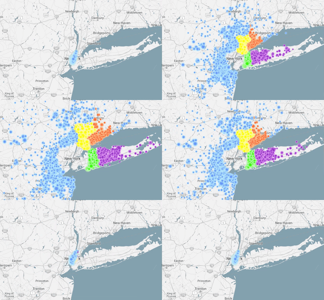
This is from 2018; it shows Greater Los Angeles commuting patterns.


This is people who work in LA County going to work and heading home:


This is people who live in LA County going to and from their jobs:


And these are both from 2016...

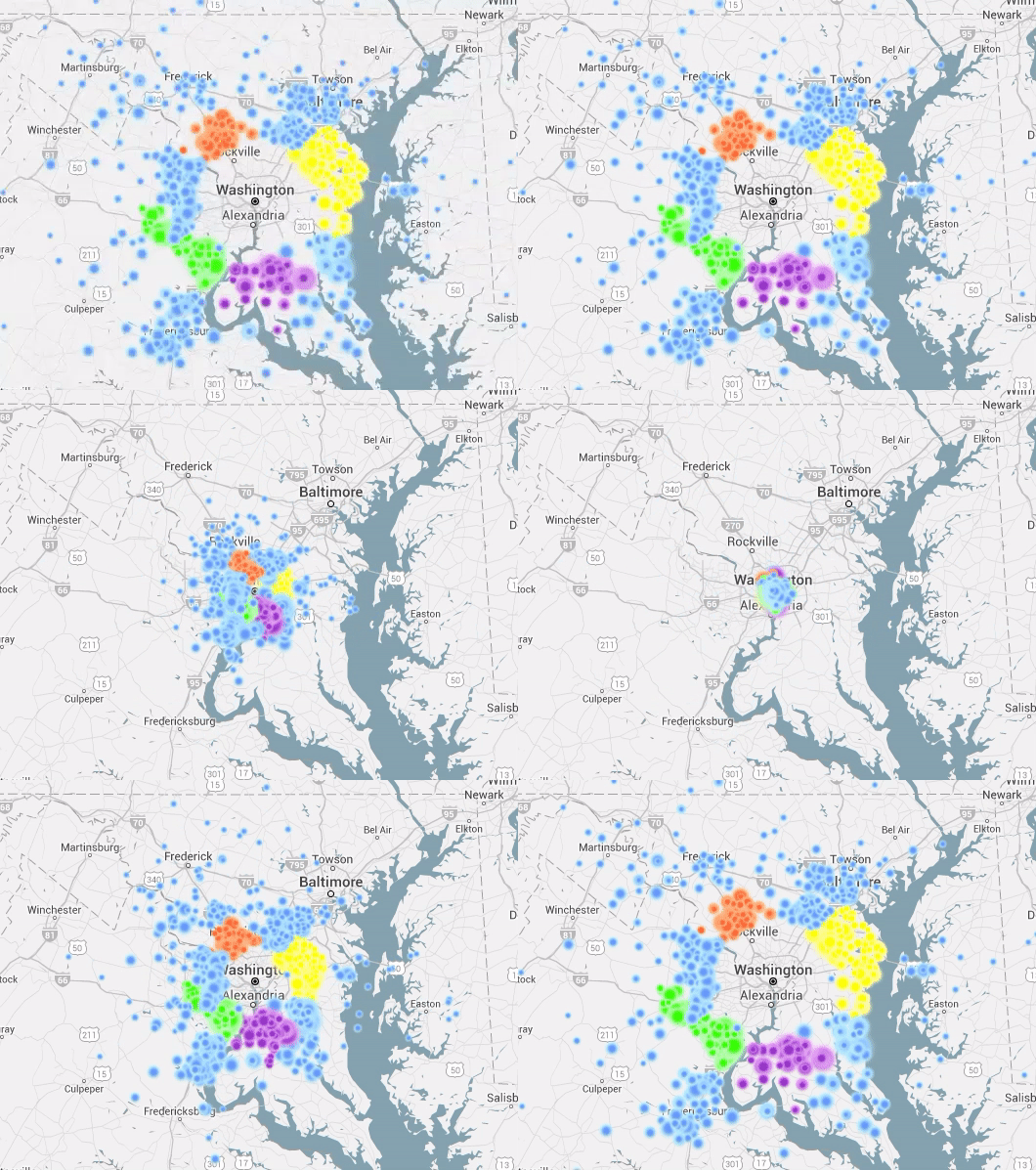
This shows people traveling between 20 and 100 miles to head to work into D.C.:


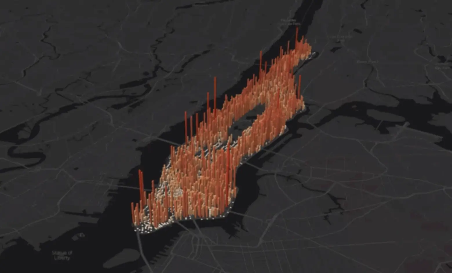
This shows people commuting to Manhattan from outside of it:
__________________
"I guess the only time people think about injustice is when it happens to them."

~ Charles Bukowski
Reply With Quote
     
     
  #8  
Old Posted Dec 1, 2025, 9:30 PM
New Brisavoine New Brisavoine is offline
Registered User
 
Join Date: Nov 2007
Posts: 4,970
Quote:
Originally Posted by Docere View Post
What's the difference between these two maps of London?
The 50 km circle.
__________________
New Axa – New Brisavoine
Reply With Quote
     
     
  #9  
Old Posted Dec 1, 2025, 9:32 PM
New Brisavoine New Brisavoine is offline
Registered User
 
Join Date: Nov 2007
Posts: 4,970
Quote:
Originally Posted by Yuri View Post
Could you provide such data for London boroughs?
This is the % of people in employment commuting to Greater London, so obviously all the London boroughs will have more than 90% commuting to Greater London.
__________________
New Axa – New Brisavoine
Reply With Quote
     
     
  #10  
Old Posted Dec 1, 2025, 10:14 PM
New Brisavoine New Brisavoine is offline
Registered User
 
Join Date: Nov 2007
Posts: 4,970
Quote:
Originally Posted by Yuri View Post
In Beijing we don't have to bother to measure commute flows between jurisdictions separated by invisible lines.

City proper has 16,411 km² and hence everything inside it is automatically Beijing metropolitan area, regardless flows.
False. 16,411 km² is the municipality of Beijing, which is like New York State. The city proper, called 城区 in Chinese (chengqu, or "city boroughs" literally), is what the Chinese authorities use as their statistical concept of the city.

At the 2020 Chinese census, the municipality of Beijing had 21,893,095 inhabitants, but the city proper of Beijing had only 17,751,681 inhabitants. The rest is either rural countryside, towns in the countryside, or cities totally distinct from Beijing (such as Yanqing for instance, which is located 70 km from Beijing and separated from Beijing by a mountain range).

This below is the ancient town of Yongning for instant. It lies 17 km from Yanqing and is separated from Yanqing by countryside. Yongning lies 71 km from Beijing and is separated from Beijing by the same mountain range that separates Yanqing from Beijing. Yongning is part of the municipality of Beijing, but it's extremely doubtful it would be considered part of the Beijing metro area. It's almost as far as Campinas from Sao Paulo.


__________________
New Axa – New Brisavoine
Reply With Quote
     
     
  #11  
Old Posted Dec 2, 2025, 12:14 AM
Yuri's Avatar
Yuri Yuri is offline
Registered User
 
Join Date: Sep 2008
Posts: 6,157
Quote:
Originally Posted by New Brisavoine View Post
This is the % of people in employment commuting to Greater London, so obviously all the London boroughs will have more than 90% commuting to Greater London.
And why is Greater London taken as reference? Why couldn't it be Inner London instead or London UA? It seems very arbitrary to me as the whole point is understand a city beyond invisible administrative borders.
__________________
London - São Paulo - Rio de Janeiro - Londrina - Frankfurt
Reply With Quote
     
     
  #12  
Old Posted Dec 2, 2025, 2:23 PM
MolsonExport's Avatar
MolsonExport MolsonExport is offline
Touching grass everyday.
 
Join Date: Oct 2003
Location: Otisburgh
Posts: 51,058
a great way to waste an hour or two: https://manpopex.us/

__________________
The whole problem with the world is that fools and fanatics are always so certain of themselves, and wiser people so full of doubts. (Bertrand Russell). Sweet Loretta fart thought she was a cleaner, but she was a frying pan. (John Lennon)
Reply With Quote
     
     
  #13  
Old Posted Dec 2, 2025, 10:04 PM
Docere Docere is offline
Registered User
 
Join Date: Jul 2014
Posts: 8,753
Toronto and Hamilton are sort of a borderline case in terms of a single or separate metro area. In 2016 just over 25% of Hamilton's workforce commuted to the Greater Toronto Area, though a lot of that was to neighboring Burlington. In 2021 it dropped slightly below 25% likely due to the pandemic.

Kitchener-Waterloo meanwhile doesn't even meet "CSA" criteria. Only around 5% commute to the Greater Toronto Area. There are regional transit links, but little direct commuting
Reply With Quote
     
     
  #14  
Old Posted Dec 3, 2025, 12:27 PM
Yuri's Avatar
Yuri Yuri is offline
Registered User
 
Join Date: Sep 2008
Posts: 6,157
Quote:
Originally Posted by Docere View Post
Toronto and Hamilton are sort of a borderline case in terms of a single or separate metro area. In 2016 just over 25% of Hamilton's workforce commuted to the Greater Toronto Area, though a lot of that was to neighboring Burlington. In 2021 it dropped slightly below 25% likely due to the pandemic.
Dpcere, I think it's important separated the "MSA" and the "metropolitan area" concept. The former is just a rule established by the US Census Bureau and the other is a concept that might be defined in countless ways.

For instance, Osaka-Kyoto-Kobe is widely regarded a single metro area since the 1960's at least and I highly doubt commute flows between them are big. They clearly have their own labour market and even distinct cultural identities.
__________________
London - São Paulo - Rio de Janeiro - Londrina - Frankfurt
Reply With Quote
     
     
  #15  
Old Posted Dec 3, 2025, 7:47 PM
Docere Docere is offline
Registered User
 
Join Date: Jul 2014
Posts: 8,753
Japan has the Urban Employment Area and the Major Metropolitan Area. The UEA is more like the US MSA and the MMA is more like the CSA. Osaka and Kyoto are separate UEAs but combined for the MMA.
Reply With Quote
     
     
  #16  
Old Posted Dec 4, 2025, 2:41 PM
PhilliesPhan's Avatar
PhilliesPhan PhilliesPhan is offline
Registered User
 
Join Date: Aug 2014
Location: Philadelphia
Posts: 1,350
Just taking a very quick glance at the data, I'm surprised that Montgomery (355) and Hartford (298) Counties, Maryland have more commuters into Philadelphia County than Cecil County, MD (283), especially since Cecil County, MD is considered part of the Philadelphia MSA. Cecil County is also a stone's throw away from SEPTA service in Newark, DE while Montgomery and Hartford County residents would have to take Amtrak.
__________________
No one outsmarts a Fox!

Temple University '18 ']['
Reply With Quote
     
     
  #17  
Old Posted Dec 4, 2025, 9:40 PM
Docere Docere is offline
Registered User
 
Join Date: Jul 2014
Posts: 8,753
Some London commuting data from 2011. Number of workers in Canary Wharf, City of London and Westminster.

https://data.london.gov.uk/download/e5mp...6bb8e/CIS2014-16%20Commuting%20Flows.pdf

This doesn't capture all commuting into Greater London; you won't find someone who lives in Slough and works at Heathrow Airport. London is a bit tricky to measure because in addition to the counties there are also a lot of unitary authorities that are counted separately. But the surrounding home counties of Essex, Hertfordshire, Kent and Surrey have a lot of commuters to London.
Reply With Quote
     
     
  #18  
Old Posted Dec 4, 2025, 10:02 PM
New Brisavoine New Brisavoine is offline
Registered User
 
Join Date: Nov 2007
Posts: 4,970
These figures are from 2011/2012:

__________________
New Axa – New Brisavoine
Reply With Quote
     
     
  #19  
Old Posted Dec 5, 2025, 3:45 AM
Docere Docere is offline
Registered User
 
Join Date: Jul 2014
Posts: 8,753
Don't have hard data but I see the London metro area or "MSA" equivalent would include Berkshire, Buckinghamshire, Essex, Hertfordshire, Kent and Surrey (including the unitary authorities within).
Reply With Quote
     
     
  #20  
Old Posted Dec 5, 2025, 2:15 PM
Yuri's Avatar
Yuri Yuri is offline
Registered User
 
Join Date: Sep 2008
Posts: 6,157
Quote:
Originally Posted by Docere View Post
Don't have hard data but I see the London metro area or "MSA" equivalent would include Berkshire, Buckinghamshire, Essex, Hertfordshire, Kent and Surrey (including the unitary authorities within).
Yes, with a population at 14 million or so: https://citypopulation.de/en/uk/agglo/. That's more UA than MSA though. Here it's London at several sizes (2021 Census numbers):


LONDON - 966 km²
6,886,883 inh.

LONDON - 1,572 km²
8,799,728 inh.

LONDON - 1,957 km²
9,426,220 inh.

LONDON - 2,170 km²
9,775,759 inh.

LONDON - 2,938 km²
10,694,252 inh.

LONDON - 2,073 km² (grouping of UAs around London, that's why the smaller size and higher population; empty spaces excluded)
12,056,039 inh.

LONDON - 5,747 km²
12,697,101 inh.

LONDON - 7,312 km²
13,250,179 inh.

LONDON - 4,769 km² (official urban agglomeration)
14,035,011 inh.

LONDON - 9,103 km²
14,595,583 inh.

LONDON - 11,190 km²
15,670,193 inh.

LONDON - 12,162 km²
15,876,845 inh.

LONDON - 17,586 km²
17,915,145 inh.
__________________
London - São Paulo - Rio de Janeiro - Londrina - Frankfurt
Reply With Quote
     
     
This discussion thread continues

Use the page links to the lower-right to go to the next page for additional posts
 
 
Reply

Go Back   SkyscraperPage Forum > Discussion Forums > City Discussions
Forum Jump


Forum Jump


All times are GMT. The time now is 10:09 AM.

     
SkyscraperPage.com - Privacy Statement - Top

Powered by vBulletin® Version 3.8.7
Copyright ©2000 - 2026, vBulletin Solutions, Inc.