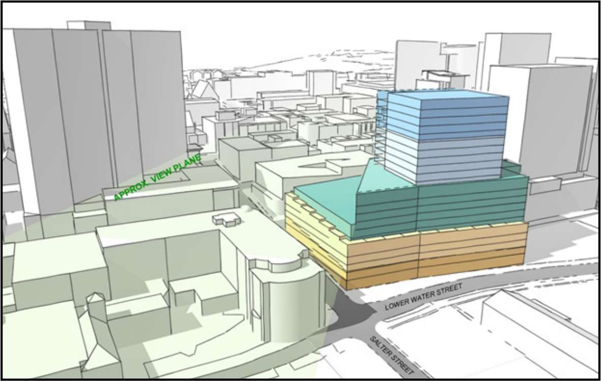
[Halifax] The Meridian (1567 Hollis) | 66 M | 21-11-6 FL | U/C
This thread is for the Canada Lands redevelopment of 1557 Hollis. This includes the Ralston Building and the small parking structure next to it on Salter Street.
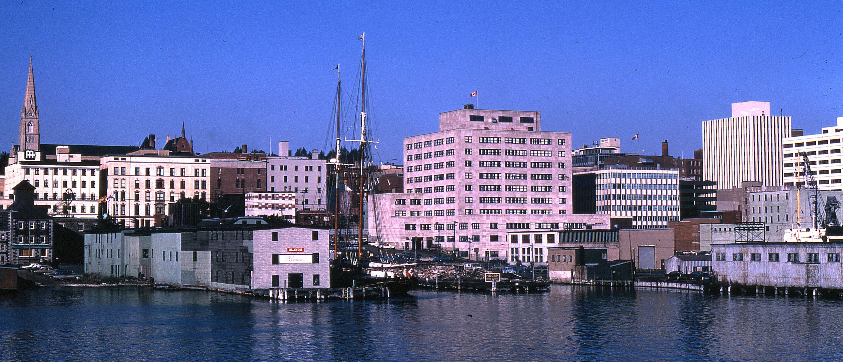
That latter photo is new to me and appears to be late 1960s given the two newer buildings (Centennial and what became the Radisson and now Hollis Hilton) on the right. That is a very rare shot of a lot of the structures in the area of Hollis and Salter that are now gone.
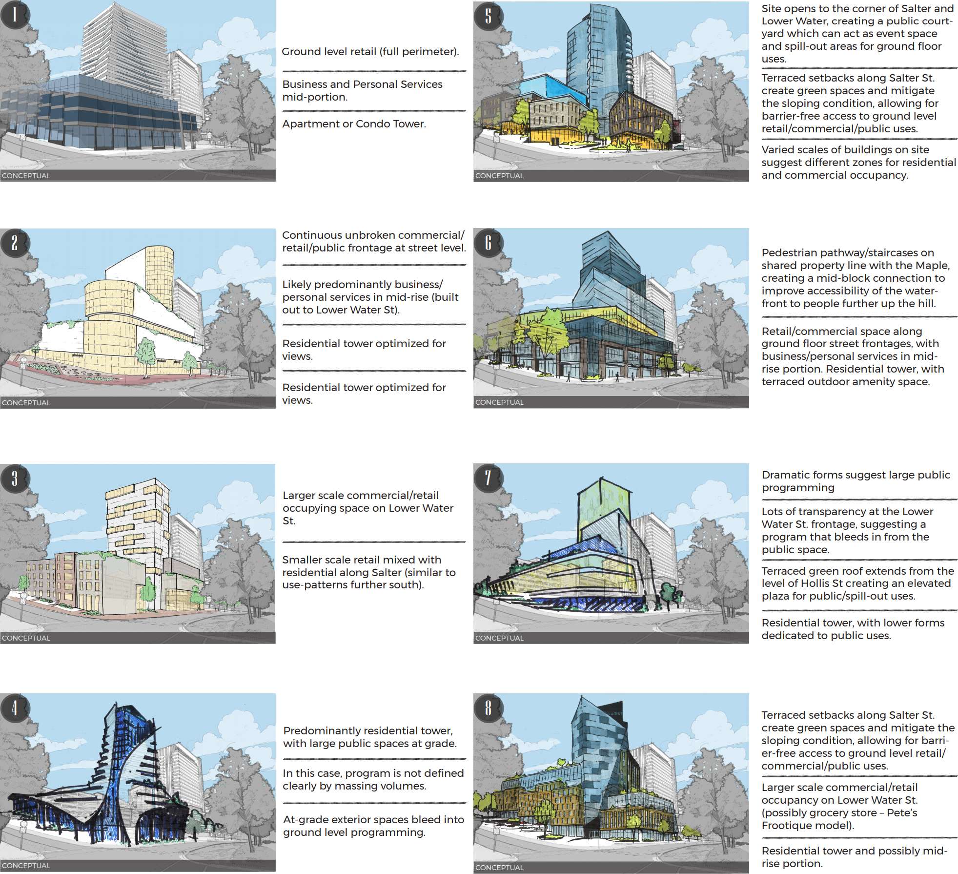
To me, concept #5 is the most interesting, but probably the least likely to be built.
That latter photo is new to me and appears to be late 1960s given the two newer buildings (Centennial and what became the Radisson and now Hollis Hilton) on the right. That is a very rare shot of a lot of the structures in the area of Hollis and Salter that are now gone.
To me, concept #5 is the most interesting, but probably the least likely to be built.
I would need to see other directional views for 5. Looks like the Maritime Centre from that drawing. I actually like number 6 but I'm wondering if it would be considered as it looks like our new Library.
__________________
I can't hear you with my eyes closed
I find concepts 2 and 3 interesting from the angle at which they're drawn... like the mid-block connection described in #6 though. #2 is maybe a bit too 80s looking, but I kind of like the hard edge on the Lower Water side. I like the way the forms manage the slope of Salter St in #3.
The concepts all show a bunch of good/bad characteristics and trade-offs.
I dislike the ones that look monolithic and/or have long uniform glass windows and storefronts at street level. The "fake village" look can also be cheesy. The Vic achieved a pretty good balance.
That latter photo is new to me and appears to be late 1960s given the two newer buildings (Centennial and what became the Radisson and now Hollis Hilton) on the right. That is a very rare shot of a lot of the structures in the area of Hollis and Salter that are now gone.
I have found very few pictures of Hollis Street or Sackville Street.
I think there might have been a time when the Maritime Centre was built but the old MT&T building, maybe both of them, were still standing where the hotel is today. Too bad they weren't preserved.
I've never found a good photo of the row of 5 storey brick buildings on Sackville Street below Hollis.
A bunch of the waterfront buildings in this picture look unremarkable but I wonder about the lighter one just east of the Ralston.
There were also a couple of random industrial buildings on the waterfront that were very old but used for up until the 1970's when they were torn down. Irving had an ironstone warehouse structure from circa 1800 that got torn down. The Historic Properties warehouses are only maybe 1/3 of the buildings of that age and type that survived until 1950. I am not sure when the Cunard building bit the dust; that one would have been worth saving too.
I see a rooftop girder structure on top of what appears to be the building on the southeast corner of Hollis and Salter, to support a neon sign of some sort. Unfortunately I cannot make out the sign.
Also of note is the Bluenose II, which was built in 1963 by Olands to promote its Schooner beer brand. Olands basically gave the schooner to the province in 1971, so given the prominent Olands branding on the pier, this would place the photo in between these two years.
Furthermore, the leftmost visible cars are from at least 1965, and I'm pretty sure the grey car in front on the left side is a 1967 Buick, due to the prominent sweep of the sheet metal down its side. So, 1967 - 1971 time period?
Its definitely post 1967 as the "new" Canadian flag is flying from the stern of the Bluenose.
I have found very few pictures of Hollis Street or Sackville Street.
The Halifax Municipal Archives have some and still appear to be adding more every now and then. Sometimes you have to poke around a little to find them, though.
I've never found a good photo of the row of 5 storey brick buildings on Sackville Street below Hollis.
Quote:
A bunch of the waterfront buildings in this picture look unremarkable but I wonder about the lighter one just east of the Ralston.
Quote:
There were also a couple of random industrial buildings on the waterfront that were very old but used for up until the 1970's when they were torn down. Irving had an ironstone warehouse structure from circa 1800 that got torn down. The Historic Properties warehouses are only maybe 1/3 of the buildings of that age and type that survived until 1950. I am not sure when the Cunard building bit the dust; that one would have been worth saving too.
The Irving warehouse had a fire in 1956:
Interestingly, you can see the Ralston Building being constructed in the background.
Post fire (dated 1957 on archives):
And was subsequently torn down (dated Oct 21, 1957 on archives site):
Edit: This looks like the same building a few years before (by the cars, I would guess 1953-54?) but with a sloped roof. From the photo it also looks like the aftermath of a fire by the holes in the roof and attached building:
Last edited by OldDartmouthMark; Jan 3, 2019 at 5:57 PM.
Reason: Found additional photo
I see a rooftop girder structure on top of what appears to be the building on the southeast corner of Hollis and Salter, to support a neon sign of some sort. Unfortunately I cannot make out the sign.
Is this the sign you're talking about? Looks like it says "Keith's Brewery".
It's in the center of the photo below (look for the "K" and you'll see the sign):


 Prev
Prev


 Linear Mode
