[Scroll down to skip the intro and get straight to the pics. The best ones - featuring rowhouses - are near the end.]
DC has a lot of temporary weekend sidewalk markets. My fiance frequently sets up booths at them selling her awesome
geography-themed stationery. Usually I spend most of the day in the booth with her, but at one particular event in the Shaw neighborhood last month it rained so heavily that there weren't very many shoppers. With extra time on my hands, I borrowed fiance's little pocket camera and set out to take a few pictures.
For more than a century after the Civil War, Shaw was the heart of DC's African-American community. It was Harlem before Harlem gained that reputation. It's where Duke Ellington led jazz bands,
go-go music was invented, and the bakery CakeLove launched the urban cupcake phenomenon that is now sweeping the nation.
However, this thread is not about the famous part.
According to DC's official neighborhood map, "Shaw" covers a huge area north of downtown, but most locals divide it into at least three distinct neighborhoods: "U Street", "Logan Circle", and "Shaw". The famous part is U Street. This thread will be about the part that locals still refer to as Shaw: the eastern section.
Here is a map, for reference. The blue shaded area is "official Shaw", but the red lettering corresponds to what locals actually call those areas.

For most of the latter half of the 20th Century, Shaw was a ghetto. Since the mid 1990s it has been gentrifying along a generally west-to-east pattern. U Street and Logan Circle have since both morphed into booming hipster neighborhoods. The eastern part, Shaw, has gentrified much more slowly, and although you cannot exactly say it is "neglected", it still bears the signs of the hurtful 20th Century.
We will start on 9th Street. Historically 9th has been a mix of residential and local-serving commercial. It is currently a pretty quiet street, but you can tell it is gentrification's next frontier. Condo infill has only barely begun to penetrate, with only a couple of new buildings.


Between 7th and 9th Streets the city built a gargantuan convention center. Most of the economic benefits have flowed south into Chinatown, leaving Shaw with little to show for it but an empty sidewalk for blocks on end.
In this first picture, the convention center is on the left.


The convention center is several blocks long, so to maintain the street grid they city punched all the cross-streets through.

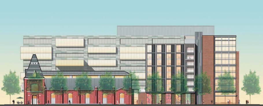
The historic heart of this area was the O Street Market, built in 1881. Now the market is one of the most visible remaining reminders of DC's neglected years. It has been empty for decades, and in 2003 the roof caved in.


If you looked closely, you may have noticed a fence around it. Ground was just broken this summer on the long-awaited redevelopment. The market building will be renovated and occupied as a Giant grocery store, and the existing obsolete suburban-style Giant store next door will be redeveloped with multifamily housing, a hotel, and additional streetfront retail.
Here are a couple of renderings, from
Shalom Baranes architects.

N Street is the northern edge of the convention center, and is the street on which the sidewalk market was held.


Here's are some closer views of that church in the distance of the previous picture.


7th Street (which becomes Georgia Avenue north of here) was the commercial heart of this area, but race riots and then urban renewal wiped it out. It's now lined mostly by ugly and urbanistically poor public housing.


Oh hai, housing projects.


To really see the neighborhood though, you have to leave the commercial streets. The rest of this post shows images from cross streets that are primarily residential, and more intact.


Here is some interesting 80s-era rowhouse infill.

And here is a very interesting condo building:


That's all, folks!


 Linear Mode
