article in today's Globe about this;
City planners take new look at urban vistas
FRANCES BULA
Special to the Globe and Mail
March 30, 2009
Vancouver is legendary as a city that has fought to prevent buildings from intruding on its spectacular mountain backdrop and ocean setting.
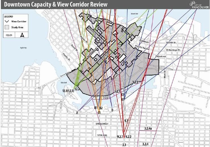
Unlike Calgary, which lost its chance to preserve views of the Rockies 25 years ago, or Toronto, which has allowed a highway plus a wall of condo towers to go up between the city and its lake, Vancouver set an aggressive policy almost two decades ago to protect more than two dozen designated view corridors.
But now the city is entertaining re-examining that controversial policy, one that has its fierce defenders and its equally fierce critics, especially the architects who have had to slice off or squish parts of buildings to make them fit around the corridors.
And the city's head planner is signalling that he's definitely open to change.
"I've got a serious appetite for shifting those view corridors," says Brent Toderian, a former Calgary planner hired two years ago, who has been working hard to set new directions in a city famous for its urban planning. "The view corridors have been one of the most monumental city-shaping tools in Vancouver's history but they need to be looked at again. We have a mountain line and we have a building line where that line is inherently subjective."
The issue isn't just about preserving views versus giving architects free rein. Vancouver has used height and density bonuses to developers with increasing frequency in return for all kinds of community benefits, including daycares, parks, theatres and social housing. A height limit means less to trade for those amenities.
Mr. Toderian, who thinks the city also needs to establish some new view corridors along with adjusting or eliminating others, says a public hearing on the issue won't happen until the fall, but he is already kicking off the discussion quietly in the hope that it will turn into a wide-ranging debate.
"The input for the last few years has been one-sided, from the people who think the view corridors should be abolished," he said.
"But we're looking forward to hearing what everyone thinks. Most people who would support them don't even think about them. They think the views we have are by accident."
The view-corridor policy, formally adopted in 1989, was the result of public complaints over some tall buildings going up, including Harbour Centre, which is now, with its tower and revolving restaurant, seen as a defining part of the Vancouver skyline. But then, it helped spur a public consultation process and policy development that many say confused the goal of preserving views with a mathematical set of rules that often didn't make sense.
One of those critics is prominent architect Richard Henriquez, who said the corridors don't protect the views that people have consistently said they value most from the city's many beaches and along streets that terminate at the water.
Instead, he says many of the view corridors are arbitrarily chosen points that preserve a shard of view for commuters coming into town.
That has resulted in the city losing billions of dollars of potential development "for someone driving along so they can get a glimpse of something for a second."
And, Mr. Henriquez argues, city residents have a wealth of exposure to the city's mountains throughout the region.
"Downtown Vancouver is a speck of urbanity in a sea of views," said Mr. Henriquez, who is feeling the problem acutely these days while he works on a development project downtown where the owners are trying to preserve a historic residential hotel, the Murray, while building an economically feasible tower on the smaller piece of land next to it.
The view corridor means the building has to be shorter and broader and is potentially undoable.
His project is one in a long list of projects that have been abandoned or altered because of view corridor rules in Vancouver. The Shangri-La Hotel, currently the tallest building in the city at 650 feet, is sliced diagonally along one side to prevent it from straying into the view corridor.
At the Woodward's project, which redeveloped the city's historic department store, one tower had to be shortened and the other raised to fit the corridor. And architect Bing Thom's plan for a crystal spire on top of a development next to the Hotel Georgia was eventually dropped because city officials refused to budge on allowing the needle-like top to protrude.
But one person wary about the city tinkering with the policy is former city councillor Gordon Price.
"When people talk about revisiting, it just means one thing: eroding," said Mr. Price, still a vocal advocate on urban issues. "People may only get this fragment of a view but it's very precious. And those fragments will become scarcer as the city grows. The longer they remain intact, the more valuable they become."
It's a debate that's unique to Vancouver. Mr. Toderian said that when he was in Calgary, there was no discussion about trying to preserve views from the downtown to the Rockies in the distance.
http://www.theglobeandmail.com/servlet/s...EW30/TPStory/TPNational/BritishColumbia/


 Prev
Prev


 )
)


 Bingo. I agree with you 100%


 Linear Mode
