[QUOTE=barbicels;9888244]Interesting thought about Bank/Riverside — I'm taking a look at it now.
Referring to this design:
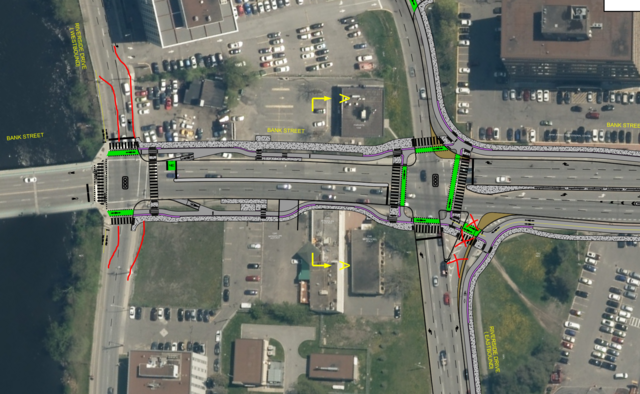
https://documents.ottawa.ca/sites/do...awing01_en.pdf
Seems that there are only two ways to go here — your way (collapse both directions of Riverside onto the current EB RoW) or the status quo (which is what the City proposes, with the addition of bike lanes and “smart channels”). Grade separation is impossible due to flood risk, and in any case the City is trying to put this junction on a diet, not add capacity as I was suggesting for Eagleson/417 and March/Teron.
Your design is limited by how many bidirectional lanes you can cram in between the property at 1355 Bank and the historic building at 1346. The treed lot at 1352 (City-owned?) and a partial expropriation at 1355 could make way for a big roundabout — was that your thinking? The plans for 1335–1339 (
https://heronpark.ca/2020/09/26/1335...t-development/) also have to be taken into account; maintaining the circulatory roadway around those buildings (and the Pebb Building) is probably essential.
My best idea, then, is to move the WB roadway south (as you suggested), converting today’s WB RoW to cycle tracks and a nice wide riverside pathway, retain the two “Michigan left” loops as clockwise circulatories to serve the properties between Riverside and the river, and grab some land around the unified intersection for either a roundabout or extra traffic lanes.
(We’re off-topic for this LRT S3 thread, so I guess this discussion should move elsewhere.)


 Prev
Prev


 Linear Mode
