HomeDiagramsDatabaseMapsForum About
     

Go Back   SkyscraperPage Forum > Regional Sections > Canada


Closed Thread

 
Thread Tools Display Modes
     
     
  #10221  
Old Posted Jun 21, 2023, 4:49 PM
Acajack's Avatar
Acajack Acajack is offline
Gros Méchant Loup
 
Join Date: Aug 2006
Location: Province 2, Canadian Empire
Posts: 72,949
Quote:
Originally Posted by q12 View Post


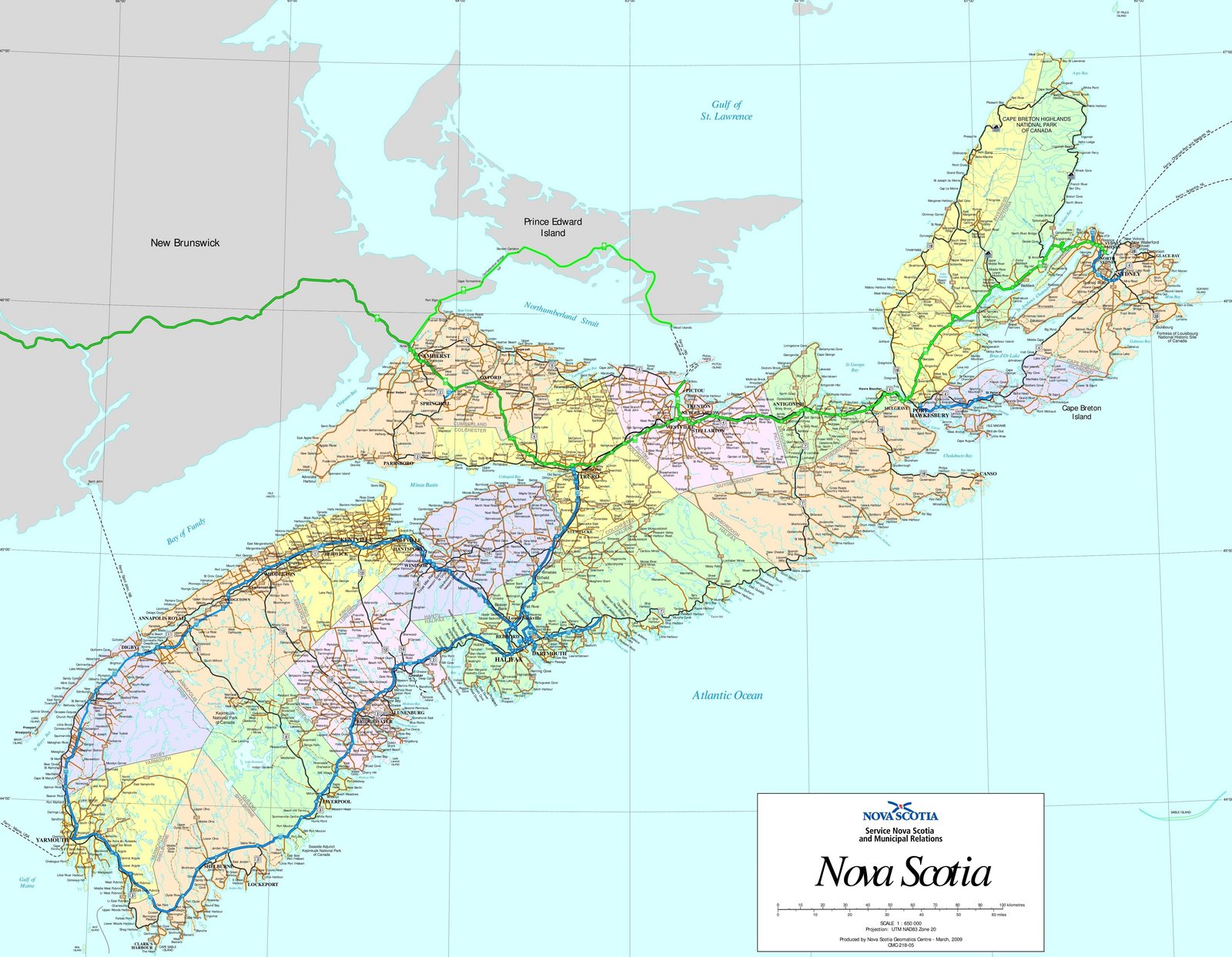
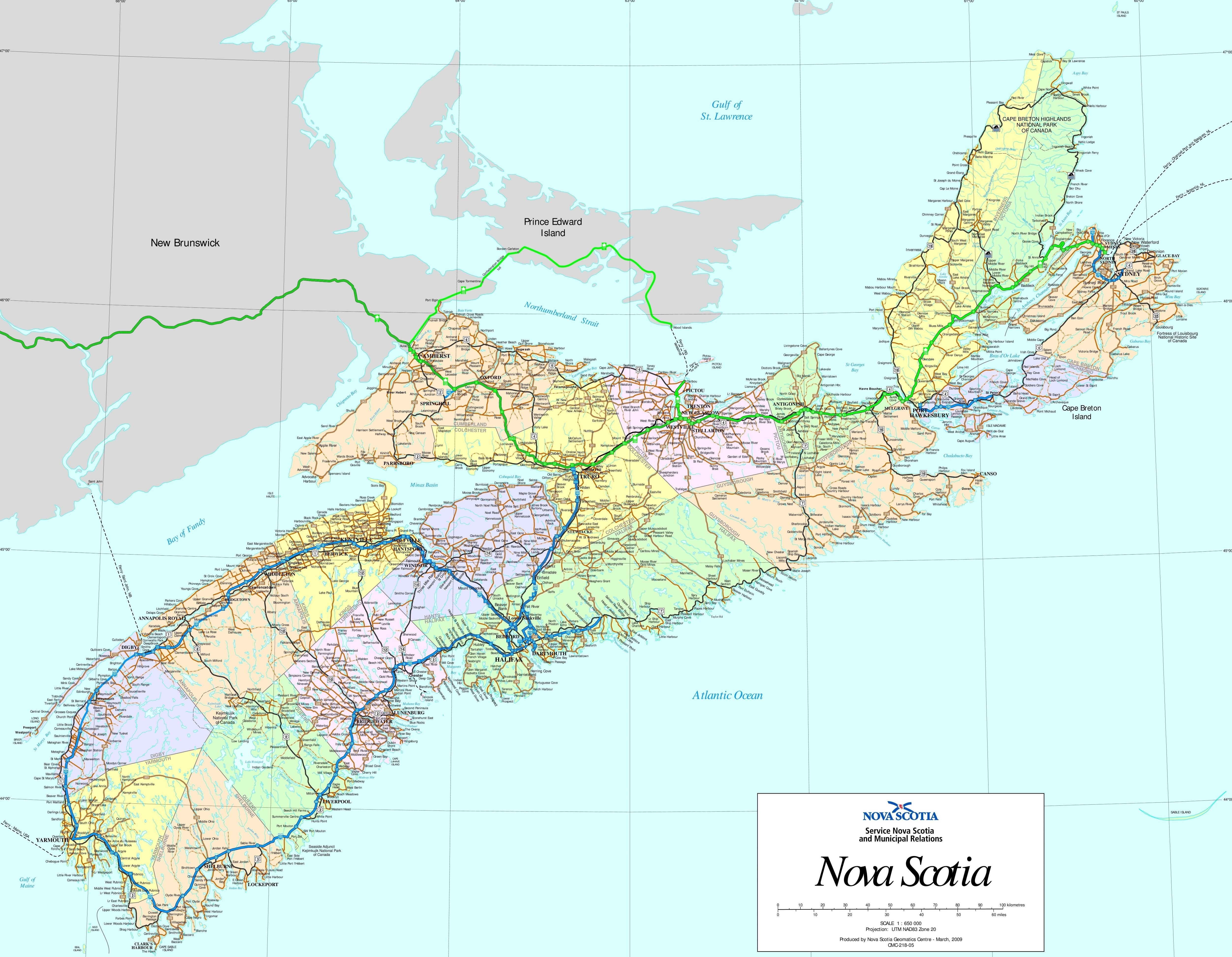
Nova Scotia has to have one of the easiest system to navigate with a simple system of the 101 runs parallel to the 1, 102 with the 2, 103 with the 3 etc.

High Res:
I think the Quebec system as described above is even easier to navigate.

The 307 is west of the 309, then going east from the 309 the numbers rise: 317, 321, 323, 327, 329, etc.

Also north-south highways are odd-numbered, east-west is even-numbered.

The autoroute the runs parallel to the two-lane Route 105 is Autoroute 5.

Autoroute numbers are generally laid out in this way, though often rounded to the nearest 5 or 10: Autoroute 40 for Route 138, Autoroute 50 for Route 148.

In Ontario you have something similar going on: the 417 and the 17, the 10 and the 410, the 416 and the 16, the 427 and the 27.

Though the 401 is roughly the same routing as old Highway 2.

That said there is no rhyme or reason either regional, geographic or sequential to Ontario's overall highway numbering.
__________________
Loin des yeux, loin du coeur.
     
     
  #10222  
Old Posted Jun 21, 2023, 4:50 PM
esquire's Avatar
esquire esquire is offline
Registered User
 
Join Date: Oct 2001
Posts: 37,480
Quote:
Originally Posted by hipster duck View Post
Kudos to Ontario for keeping the old monarchist flame alive! That's the Ontario I remember: the Lord's prayer in schools and a portrait of the Queen in every hockey rink.

Whether it was due to our province's old school conservative streak or our penny pinching fiscal conservatism (two sides of the same coin, I guess), we'll never know, but we resisted that designed-by-committee crap in the late 1980s unlike many other provinces.
I was thinking the same thing. Those highway signs are a prominent display of the fast-fading "old Ontario". I wonder how much longer they will last.
     
     
  #10223  
Old Posted Jun 21, 2023, 5:19 PM
manny_santos's Avatar
manny_santos manny_santos is offline
Registered User
 
Join Date: Jul 2006
Location: New Westminster
Posts: 5,141
Quote:
Originally Posted by swimmer_spe View Post
BC has poor standards. They like removable centre median guardrails. They have inadequate drainage for the weather they get. They also like traffic lights on highways that shouldn't have any.
I've only lived in BC since 2020, but what surprised me is that Highway 91 has only been a full freeway since 2018. They still had a traffic light at 72nd Avenue in Surrey until an interchange was completed there that year.

Highway 17, which was extended from Tsawwassen to Highway 1 in Surrey a decade ago, is built to poor standards - bad vertical geometry in places, and multiple traffic lights. They are slowly upgrading it, most recently with a new grade separation for Old Yale Road that just started construction this spring as part of the Pattullo Bridge replacement project.
     
     
  #10224  
Old Posted Jun 21, 2023, 5:20 PM
Innsertnamehere's Avatar
Innsertnamehere Innsertnamehere is offline
Registered User
 
Join Date: Jan 2010
Location: Hamilton
Posts: 12,831
I don't think Ontario's highway signage is going anywhere - Ontario attempted updating it's license plates from the same design it's more or less had since the late 1960's (minus some small tweaks) and got nowhere with that, so..

Also - "King's Highway" finally makes sense again for the first time since the 1950's when the modern freeway network was basically still just a glint in a traffic engineer's eye. Why change it now?

Regarding Ontario's highway numbering - agreed that it needs an overhaul. It's only gotten worse since the 1990's when half the provincial highway network was downloaded to municipalities which further splintered the highway naming scheme.

The worst part of Ontario's network to me is the mix of freeway numbering, with some freeways getting a 400 series designation (makes sense!), some retaining the original highway designation (7, 8, 85, etc.), some having a 100-series number (115, 174) for some reason (???), and some not even having a number as they are municipally owned (Gardiner, DVP, Linc, Red Hill Parkway, E.C. Row, etc.)!

It matters less these days because of the rise of GPS, but the province really needs to comprehensively look at the provincial highway numbering scheme and update it.
     
     
  #10225  
Old Posted Jun 21, 2023, 5:27 PM
manny_santos's Avatar
manny_santos manny_santos is offline
Registered User
 
Join Date: Jul 2006
Location: New Westminster
Posts: 5,141
Quote:
Originally Posted by Acajack View Post
I think the Quebec system as described above is even easier to navigate.

The 307 is west of the 309, then going east from the 309 the numbers rise: 317, 321, 323, 327, 329, etc.

Also north-south highways are odd-numbered, east-west is even-numbered.

The autoroute the runs parallel to the two-lane Route 105 is Autoroute 5.

Autoroute numbers are generally laid out in this way, though often rounded to the nearest 5 or 10: Autoroute 40 for Route 138, Autoroute 50 for Route 148.

In Ontario you have something similar going on: the 417 and the 17, the 10 and the 410, the 416 and the 16, the 427 and the 27.

Though the 401 is roughly the same routing as old Highway 2.

That said there is no rhyme or reason either regional, geographic or sequential to Ontario's overall highway numbering.
My only real complaint about Ontario's highway numbering is the County/Regional Road system:

- It is not numbered separately from the King's Highway network (e.g. there's Highway 6 and numerous roads signed as County Road 6 or Regional Road 6, at least one of which actually intersects with Highway 6)

- Numbers are routinely duplicated between counties/regions

- Numbers change at county/regional boundaries, which are generally meaningless boundaries to most drivers (unlike provincial or international borders)

- The numbering is quite excessive, especially in urban areas and is likely unnecessary. Notably, it leads to confusion for GPS users, as Google Maps sometimes insists on using Regional Road numbers in navigation and the numbers are either obscure or not signed. This is particularly an issue in Ottawa.

I've long believed that the full province of Ontario should either have a Secondary Highway system that is applied beyond just Northern Ontario, or a US-style County Road network that uses separate numbering from primary highways (e.g. California, where County Roads have a letter-number scheme, such as County Road S21 which is the former US-101 in San Diego County). It doesn't matter who owns the road, they can still be owned and maintained at the municipal level in Southern Ontario, but at least in rural areas there should be some sort of logical numbering system to differentiate them from primary Highways, as is done in almost every other jurisdiction in North America.

As I understand it, Ontario's County Roads existed before the province even owned highways within the province, but the numbering was an internal scheme developed independently of other counties and the numbers weren't posted until the 1960s or 70s.

     
     
  #10226  
Old Posted Jun 21, 2023, 5:38 PM
Innsertnamehere's Avatar
Innsertnamehere Innsertnamehere is offline
Registered User
 
Join Date: Jan 2010
Location: Hamilton
Posts: 12,831
many municipalities don't even use county road numbering (Toronto for example), while others use it sparingly (Hamilton only uses it as numbers on former provincial highways), and others plaster useless numbers on some, but not all urban arterial roads (Peel Region) for some reason.. It's just a massive mess.
     
     
  #10227  
Old Posted Jun 21, 2023, 5:43 PM
manny_santos's Avatar
manny_santos manny_santos is offline
Registered User
 
Join Date: Jul 2006
Location: New Westminster
Posts: 5,141
Quote:
Originally Posted by Innsertnamehere View Post
I don't think Ontario's highway signage is going anywhere - Ontario attempted updating it's license plates from the same design it's more or less had since the late 1960's (minus some small tweaks) and got nowhere with that, so..

Also - "King's Highway" finally makes sense again for the first time since the 1950's when the modern freeway network was basically still just a glint in a traffic engineer's eye. Why change it now?

Regarding Ontario's highway numbering - agreed that it needs an overhaul. It's only gotten worse since the 1990's when half the provincial highway network was downloaded to municipalities which further splintered the highway naming scheme.

The worst part of Ontario's network to me is the mix of freeway numbering, with some freeways getting a 400 series designation (makes sense!), some retaining the original highway designation (7, 8, 85, etc.), some having a 100-series number (115, 174) for some reason (???), and some not even having a number as they are municipally owned (Gardiner, DVP, Linc, Red Hill Parkway, E.C. Row, etc.)!

It matters less these days because of the rise of GPS, but the province really needs to comprehensively look at the provincial highway numbering scheme and update it.
Ontario highway shields erected in the past 30 years don't even mention "The King's Highway". I believe that was removed to ensure the sign met bilingual standards.

174 in Ottawa isn't even a King's Highway number, that's a number added by the City of Ottawa.
     
     
  #10228  
Old Posted Jun 21, 2023, 5:50 PM
Acajack's Avatar
Acajack Acajack is offline
Gros Méchant Loup
 
Join Date: Aug 2006
Location: Province 2, Canadian Empire
Posts: 72,949
Quote:
Originally Posted by manny_santos View Post
My only real complaint about Ontario's highway numbering is the County/Regional Road system:

- It is not numbered separately from the King's Highway network (e.g. there's Highway 6 and numerous roads signed as County Road 6 or Regional Road 6, at least one of which actually intersects with Highway 6)

- Numbers are routinely duplicated between counties/regions

- Numbers change at county/regional boundaries, which are generally meaningless boundaries to most drivers (unlike provincial or international borders)

- The numbering is quite excessive, especially in urban areas and is likely unnecessary. Notably, it leads to confusion for GPS users, as Google Maps sometimes insists on using Regional Road numbers in navigation and the numbers are either obscure or not signed. This is particularly an issue in Ottawa.
.
Yes, I have to say this is extremely annoying.

Quebec doesn't have county roads, so when in the countryside everything is either a provincial (numbered) highway or a (named) municipal road.

The provincial highway system seems to drill down deeper in Quebec, with third-tier highways numbered in the 300s north of the St Lawrence, and in the 200s south of the river.

More often than not in Quebec, if you're on the main road between any two towns or even two villages, it's going to be a numbered provincial highway.
__________________
Loin des yeux, loin du coeur.
     
     
  #10229  
Old Posted Jun 21, 2023, 6:02 PM
esquire's Avatar
esquire esquire is offline
Registered User
 
Join Date: Oct 2001
Posts: 37,480
Manitoba has three levels of provincial roads...

provincial roads - the lowest level of provincial highway, they can be gravel or paved. They usually connect small towns and rural areas. Some were offloaded to municipalities in recent decades

provincial trunk highways - the backbone of the highway network - the major highways fall in this class. Most are paved, some are twinned.

three-digit trunk highways (100, 101, 110, 190) which are urban expressways - I believe these are just a subclass of provincial trunk highways and not a formal standalone category, but they are effectively treated differently than regular trunk highways

Then of course there are local municipal roads below the provincial network.
     
     
  #10230  
Old Posted Jun 21, 2023, 6:20 PM
swimmer_spe swimmer_spe is offline
BANNED
 
Join Date: Apr 2014
Posts: 10,743
Quote:
Originally Posted by manny_santos View Post
I've only lived in BC since 2020, but what surprised me is that Highway 91 has only been a full freeway since 2018. They still had a traffic light at 72nd Avenue in Surrey until an interchange was completed there that year.

Highway 17, which was extended from Tsawwassen to Highway 1 in Surrey a decade ago, is built to poor standards - bad vertical geometry in places, and multiple traffic lights. They are slowly upgrading it, most recently with a new grade separation for Old Yale Road that just started construction this spring as part of the Pattullo Bridge replacement project.
BC does things as cheaply as they can get away with.

Quote:
Originally Posted by manny_santos View Post
My only real complaint about Ontario's highway numbering is the County/Regional Road system:

- It is not numbered separately from the King's Highway network (e.g. there's Highway 6 and numerous roads signed as County Road 6 or Regional Road 6, at least one of which actually intersects with Highway 6)

- Numbers are routinely duplicated between counties/regions

- Numbers change at county/regional boundaries, which are generally meaningless boundaries to most drivers (unlike provincial or international borders)

- The numbering is quite excessive, especially in urban areas and is likely unnecessary. Notably, it leads to confusion for GPS users, as Google Maps sometimes insists on using Regional Road numbers in navigation and the numbers are either obscure or not signed. This is particularly an issue in Ottawa.

I've long believed that the full province of Ontario should either have a Secondary Highway system that is applied beyond just Northern Ontario, or a US-style County Road network that uses separate numbering from primary highways (e.g. California, where County Roads have a letter-number scheme, such as County Road S21 which is the former US-101 in San Diego County). It doesn't matter who owns the road, they can still be owned and maintained at the municipal level in Southern Ontario, but at least in rural areas there should be some sort of logical numbering system to differentiate them from primary Highways, as is done in almost every other jurisdiction in North America.

As I understand it, Ontario's County Roads existed before the province even owned highways within the province, but the numbering was an internal scheme developed independently of other counties and the numbers weren't posted until the 1960s or 70s.

One of the issues is the downloading of highways in the 1990s. In some places, that is the cause for the mess you see now.
     
     
  #10231  
Old Posted Jun 21, 2023, 8:39 PM
craner's Avatar
craner craner is offline
Go Tall or Go Home
 
Join Date: Mar 2007
Location: Calgary
Posts: 7,373
Quote:
Originally Posted by Masoliantekw View Post
It is still logical and practical.
Here's a homemade diagram of our highway system :

Quote:
Originally Posted by Acajack View Post
Is it bad if we copied what might be a good idea the Americans had?
No it’s a great idea - if it’s a good, logical system why not copy it.
Nice diagram too. My only question is why the ‘73’ was not numbered ‘75’ ?
     
     
  #10232  
Old Posted Jun 21, 2023, 8:48 PM
SignalHillHiker's Avatar
SignalHillHiker SignalHillHiker is offline
I ♣ Baby Seals
 
Join Date: Jul 2012
Location: Sin Jaaawnz, Newf'nland
Posts: 36,268
We use highway numbers, official highway names, and then an often-separate name that everyone calls them.

I.E. Route 2's official name is Pitt's Memorial Drive or Peacekeeper's Way depending which section. Absolutely no one normal says Route 2, most say Pitt's Memorial Drive, older people say Harbour Arterial.

Route 230's official name is Discovery Trail, no one says Route 230, some say Discovery Trail (the type who don't have a discernible NL accent), and most people call it the Bonavista Highway.

Route 210's official name is Heritage Run, yada yada as above, most people call it the Burin Peninsula Highway.
__________________
Note to self: "The plural of anecdote is not evidence."
     
     
  #10233  
Old Posted Jun 21, 2023, 8:53 PM
harls's Avatar
harls harls is offline
Mooderator
 
Join Date: Jan 2002
Location: Aylmer, Québec
Posts: 21,386
Quote:
Originally Posted by craner View Post
No it’s a great idea - if it’s a good, logical system why not copy it.
Nice diagram too. My only question is why the ‘73’ was not numbered ‘75’ ?
I am guessing they planned to build a 75 east of the 73 one day.
     
     
  #10234  
Old Posted Jun 21, 2023, 9:15 PM
esquire's Avatar
esquire esquire is offline
Registered User
 
Join Date: Oct 2001
Posts: 37,480
Quote:
Originally Posted by harls View Post
I am guessing they planned to build a 75 east of the 73 one day.
I recently read a newspaper article about the Metro Route system in Winnipeg that was rolled out in the 1960s... it was a way to identify and develop major routes at a time when the road network in Winnipeg was pretty disjointed.

Initially there were round numbered routes (e.g., 50, 60 and so on) but for whatever reason people saw the signs and confused them with posted speed limits and thought it was carte blanche to drive 50 mph, etc. So Metro Winnipeg changed its approach and switched the routes to 52, 62, etc. to eliminate confusion and prevent that from happening.

Although on second thought that probably wasn't the thinking in Quebec given the various speed-limit like numbers in use for Autoroutes
     
     
  #10235  
Old Posted Jun 21, 2023, 10:48 PM
swimmer_spe swimmer_spe is offline
BANNED
 
Join Date: Apr 2014
Posts: 10,743
I wonder, does it actually make sense to have a special numbering system?

There are really only 2 provinces that have full freeways throughout enough of their provinces to matter. NS; Your super 2s don't count. BC; talk to me when your highways do not need a rebuild in winter. NB; 2 expressways does not equal a network. SK, MB and AB; Talk to me when they are true limited access. NL; Talk to BC about how to expand.

This leaves ON and QC. ON decided to take the old highway and just stick a 4 in front of it. QC, you want to be like the USA. Reality is, both are good enough and none is really better than the other.

What would be better is for the country to have one standard and the rest follow it. For instance, can someone tell the MTQ to build acceleration and deceleration lanes?
     
     
  #10236  
Old Posted Jun 22, 2023, 12:48 AM
q12's Avatar
q12 q12 is offline
Registered User
 
Join Date: Mar 2008
Location: Halifax
Posts: 5,131
Quote:
Originally Posted by swimmer_spe View Post
There are really only 2 provinces that have full freeways throughout enough of their provinces to matter. NS; Your super 2s don't count. BC; talk to me when your highways do not need a rebuild in winter. NB; 2 expressways does not equal a network. SK, MB and AB; Talk to me when they are true limited access. NL; Talk to BC about how to expand.

This leaves ON and QC.
Nova Scotia and New Brunswick (pop. 1,885,674) blow Ontario and Quebec (pop. 24,430,646) out of the water when it comes to freeways per capita.
     
     
  #10237  
Old Posted Jun 22, 2023, 3:11 AM
swimmer_spe swimmer_spe is offline
BANNED
 
Join Date: Apr 2014
Posts: 10,743
Quote:
Originally Posted by q12 View Post
Nova Scotia and New Brunswick (pop. 1,885,674) blow Ontario and Quebec (pop. 24,430,646) out of the water when it comes to freeways per capita.
All of the major cities in ON and QC are connected by a freeway. I don't think the same can be said for NS and NB.
     
     
  #10238  
Old Posted Jun 22, 2023, 10:11 AM
Innsertnamehere's Avatar
Innsertnamehere Innsertnamehere is offline
Registered User
 
Join Date: Jan 2010
Location: Hamilton
Posts: 12,831
Absolutely it can, other than maybe Sydney.. but Ontario and Quebec have towns around the same size off the freeway network as well.
     
     
  #10239  
Old Posted Jun 22, 2023, 11:12 AM
Dengler Avenue's Avatar
Dengler Avenue Dengler Avenue is offline
Road Engineer Wannabe
 
Join Date: Sep 2017
Location: Côté Ouest de la Rivière des Outaouais
Posts: 8,669
Quote:
Originally Posted by Innsertnamehere View Post
Absolutely it can, other than maybe Sydney.. but Ontario and Quebec have towns around the same size off the freeway network as well.
I always find it odd that roads connecting big places like Hamilton-Cambridge Highway (8), Guelph-Cambridge-Brantford Highway (24), Kitchener-Guelph Highway (7), Stratford - Kitchener Highway (7&8), Orangeville-King Highway (9), Whitby-Orillia Highway (12) only have 2 lanes. A lot of these are in Greater Golden Horseshoe too…
__________________
My Proposal of TCH Twinning in Northern Ontario
Disclaimer: Most of it is pure pie in the sky, so there's no need to be up in the arm about it.
     
     
  #10240  
Old Posted Jun 22, 2023, 1:16 PM
MonctonRad's Avatar
MonctonRad MonctonRad is offline
Wildcats Rule!!
 
Join Date: Jun 2008
Location: Moncton NB
Posts: 40,967
Quote:
Originally Posted by swimmer_spe View Post
NB; 2 expressways does not equal a network.
It's more than just Highways 1 & 2 which are divided in NB.

The entire length of NB-95 is divided to the US border (connecting to I-95). A decent chunk of Highways 11 & 15 are divided near Moncton (11 as far north as nearly Bouctouche). Parts of Highway 7 from SJ to Freddy are also divided.

All totaled, there are probably at least 850 km of totally grade separated dual carriageway in the province. Not bad for a province with less than 850k people.

How many provinces in the country can say you can drive their entire length on a divided highway? It doesn't even matter if you're talking about a pan Canadian route, or connecting traffic to the US! The statement is true in either event. In fact, we have two divided highways leading to the US (NB-1 & NB-95).
__________________
Go 'Cats Go
     
     
This discussion thread continues

Use the page links to the lower-right to go to the next page for additional posts
 
 
Closed Thread

Go Back   SkyscraperPage Forum > Regional Sections > Canada
Forum Jump


Forum Jump


All times are GMT. The time now is 8:21 AM.

     
SkyscraperPage.com - Privacy Statement - Top

Powered by vBulletin® Version 3.8.7
Copyright ©2000 - 2026, vBulletin Solutions, Inc.