HomeDiagramsDatabaseMapsForum About
     

Go Back   SkyscraperPage Forum > Regional Sections > Canada > Alberta & British Columbia > Vancouver > Metro Vancouver & the Fraser Valley


Reply

 
Thread Tools Display Modes
     
     
  #4301  
Old Posted Jul 25, 2022, 9:17 AM
Migrant_Coconut's Avatar
Migrant_Coconut Migrant_Coconut is offline
Registered User
 
Join Date: Oct 2015
Location: Kitsilano/Fairview
Posts: 10,027
Given that Burnaby Council won't even fund an overpass right now... let's not hold our breath.
Reply With Quote
     
     
  #4302  
Old Posted Jul 25, 2022, 2:51 PM
officedweller officedweller is offline
Registered User
 
Join Date: Jul 2001
Location: Vancouver
Posts: 41,447
I was wondering if the span over the tracks would touch down in the median between Central Blvd and Beresford
- and just provide an at grade access point between the building and the SkyTrain station.
Reply With Quote
     
     
  #4303  
Old Posted Jul 25, 2022, 5:28 PM
Sheba Sheba is offline
Registered User
 
Join Date: Jan 2015
Location: BC
Posts: 4,578
Quote:
Originally Posted by officedweller View Post
I was wondering if the span over the tracks would touch down in the median between Central Blvd and Beresford
- and just provide an at grade access point between the building and the SkyTrain station.
I think it's a pretty safe bet any Willingdon Skytrain would be underground at Metrotown - the area is on a ridge.
Reply With Quote
     
     
  #4304  
Old Posted Jul 25, 2022, 5:55 PM
jollyburger jollyburger is offline
Registered User
 
Join Date: Dec 2015
Posts: 15,526
Quote:
Originally Posted by Migrant_Coconut View Post
Given that Burnaby Council won't even fund an overpass right now... let's not hold our breath.
They just provided an update on civic buildings projects with budgets over $800 million and I think you discount the ability of politicians to fund a building that they'll be using.

https://pub-burnaby.escribemeetings.com/filestream.ashx?DocumentId=61695
Reply With Quote
     
     
  #4305  
Old Posted Jul 25, 2022, 6:00 PM
jollyburger jollyburger is offline
Registered User
 
Join Date: Dec 2015
Posts: 15,526


Quote:
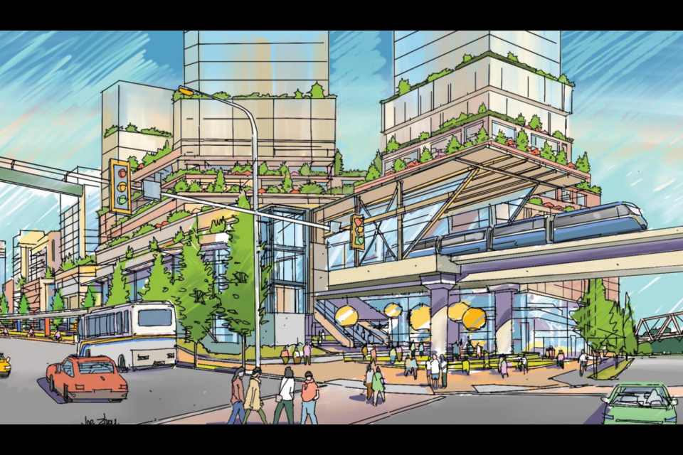
Burnaby prepares for urban village life at Bainbridge, Lochdale

Burnaby city staff have finalized plans for two new urban villages in Burnaby.

The Bainbridge and Lochdale urban villages are planned to be communities “bridging the gap” between larger town centres like Metrotown and Brentwood and smaller-scale residential neighbourhoods.

They’ve been designed with multi-family densities and accessible community services, working towards a “15-minute city.”

The plans are intended to guide incremental development over the next 30 years, with shorter-term plans beginning in the denser areas.

The urban villages will provide market and non-market housing options and types, including transit-oriented housing (dense, multi-family apartment housing), low- to mid-rise housing (multi-family apartment housing, often with townhouses at ground level), and ground-oriented housing like triplexes, fourplexes, townhouses and rowhouses.

Streetscapes would be designed as “urban ‘living rooms’” with public art, greenery and open spaces for socializing.

The plans would incorporate weather-protected areas, like awnings over pedestrian and seating areas, universal washrooms and publicly accessible bike facilities like repair tools, air pumps and e-bike chargers along high-traffic routes.

The plans have come out of three phases of public consultation.

Burnaby’s Bainbridge urban village
The Bainbridge urban village, to the northwest of Burnaby Lake and southeast of the Sperling-Burnaby Lake SkyTrain station, includes low-, medium- and high-densities for residential and commercial spaces, as well as land designated for park and community uses.

In the highest density area, buildings could be up to 20 storeys, with a landmark building of up to 25 storeys near the SkyTrain station.

Individual character areas within the Bainbridge urban village include a village centre with public plazas and dense transit-oriented development and a high street marked by retail businesses and a social atmosphere with restaurants and shopping.

Neighbourhood squares and residential cores also make up the character areas.

The report says an additional elementary school may be needed to serve the growing Bainbridge community. The plan also notes that high-density developments will bring “substantial child-care demand” and suggests on-site child-care facilities.

The finalized Bainbridge plan remains mostly the same as the draft plan, though densities in some areas were decreased.

Coun. Pietro Calendino expressed disappointment at the planning and development committee about the lowered densities, especially between Lougheed Highway and Collister Drive.

Coun. Alison Gu said she was concerned whether mobility infrastructure, like pieces of sidewalk and cycling lanes, would be built as development happens, which she said can expose people to unnecessary risk as riders follow a protected cycling lane before it ends and the lane “spits you out into traffic.” Gu hoped safe pedestrian and cycling mobility infrastructure could be pre-established.

The Bainbridge community is home to 1,635 people, according to the 2016 census, with more than half its housing stock (64 per cent) built in the 1970s.

According to city data, 48 per cent of the land is used for housing, most of it single-family.

Plans for the Lochdale urban village in Burnaby
The Lochdale urban village, between Capitol Hill on the west and Burnaby Mountain at its east, has a population of more than 3,000.

Almost half (47 per cent) of its housing stock was built pre-1970.

Character areas of the Lochdale urban village include a village centre oriented towards Hastings Street, between Kensington and Clare Avenues and including the Kensington Square Shopping Centre.

As a public realm space, with multi-purpose plazas, its imagined retail and commercial uses may “spill” onto the street, as in outdoor restaurant patios and retail displays, without obstructing transportation access.

Building heights would range from three to 20 storeys.

A parks district would be characterized by lower-scale four- to six-storey mixed-use and multi-family buildings, with some opportunities for live-work units and artist studios and workshops, fronting Hastings.

Ground-oriented residential areas would incorporate missing-middle housing to the village neighbourhood.
https://www.burnabynow.com/local-news/bu...lage-life-at-bainbridge-lochdale-5609312
Reply With Quote
     
     
  #4306  
Old Posted Jul 25, 2022, 9:43 PM
officedweller officedweller is offline
Registered User
 
Join Date: Jul 2001
Location: Vancouver
Posts: 41,447
Quote:
Originally Posted by Sheba View Post
I think it's a pretty safe bet any Willingdon Skytrain would be underground at Metrotown - the area is on a ridge.
I meant the west end of the existing Metrotown Station.


Last edited by officedweller; Jul 25, 2022 at 10:11 PM.
Reply With Quote
     
     
  #4307  
Old Posted Jul 25, 2022, 11:49 PM
Migrant_Coconut's Avatar
Migrant_Coconut Migrant_Coconut is offline
Registered User
 
Join Date: Oct 2015
Location: Kitsilano/Fairview
Posts: 10,027
I think they'll want to reserve the space around the SkyTrain for the Purple Line entrance. No sense in having another cross-the-street transfer when there's a perfectly good greenway right there.
Reply With Quote
     
     
  #4308  
Old Posted Jul 26, 2022, 1:21 AM
Sheba Sheba is offline
Registered User
 
Join Date: Jan 2015
Location: BC
Posts: 4,578
Quote:
Originally Posted by Migrant_Coconut View Post
No sense in having another cross-the-street transfer when there's a perfectly good greenway right there.
McKay doesn't cross the BC Parkway - it's a T intersection. That pic of officedweller's shows where the entrance could be at ground level just to the west of Metrotown Station.

If they have any plans to extend the line south of Central / Beresford then it would make more sense to have line and station under Willingdon so it doesn't have to swerve to get around the new towers underground parking.
Reply With Quote
     
     
  #4309  
Old Posted Jul 26, 2022, 1:49 AM
Migrant_Coconut's Avatar
Migrant_Coconut Migrant_Coconut is offline
Registered User
 
Join Date: Oct 2015
Location: Kitsilano/Fairview
Posts: 10,027
Quote:
Originally Posted by Sheba View Post
McKay doesn't cross the BC Parkway - it's a T intersection. That pic of officedweller's shows where the entrance could be at ground level just to the west of Metrotown Station.

If they have any plans to extend the line south of Central / Beresford then it would make more sense to have line and station under Willingdon so it doesn't have to swerve to get around the new towers underground parking.
That's my point - if I were TransLink, I'd start trying to option that stretch of the greenway (at least until the station was finished).

At any rate, why would the new city hall need that kind of overhang? Bragging rights?
Reply With Quote
     
     
  #4310  
Old Posted Jul 26, 2022, 2:16 AM
Sheba Sheba is offline
Registered User
 
Join Date: Jan 2015
Location: BC
Posts: 4,578
Quote:
Originally Posted by Migrant_Coconut View Post
That's my point - if I were TransLink, I'd start trying to option that stretch of the greenway (at least until the station was finished).
The plan is to keep the greenway pretty much as is. Ok they might add some seating around a plaza but there won't be any actual building projects on it for a very long time, if ever. I doubt TransLink really needs to do much beyond submit plans to Burnaby about what they want to do.

I'm not sure who owns the greenway now - BC Hydro or the cities it passes through. I doubt TransLink does, despite the BC Parkway running along it.
Reply With Quote
     
     
  #4311  
Old Posted Jul 26, 2022, 5:16 AM
officedweller officedweller is offline
Registered User
 
Join Date: Jul 2001
Location: Vancouver
Posts: 41,447
Quote:
Originally Posted by Migrant_Coconut View Post
That's my point - if I were TransLink, I'd start trying to option that stretch of the greenway (at least until the station was finished).

At any rate, why would the new city hall need that kind of overhang? Bragging rights?
Yeah - 'landmark architecture'.
Agreed reserving an RoW under the parkway for a transfer walkway / corridor from the new Willingdon Satation, although they could build that under either street (with more disruption).
Reply With Quote
     
     
  #4312  
Old Posted Aug 5, 2022, 5:14 AM
officedweller officedweller is offline
Registered User
 
Join Date: Jul 2001
Location: Vancouver
Posts: 41,447
Concert's $7.5 million donation recognized with new name for future BCIT building
https://dailyhive.com/vancouver/bcit-concert-properties-centre-for-trades-and-technology


Artistic rendering of the new trades and technology centre at BCIT Burnaby. (Hughes Condon Marler Architects)
https://dailyhive.com/vancouver/bcit-concert-properties-centre-for-trades-and-technology
Reply With Quote
     
     
  #4313  
Old Posted Aug 5, 2022, 5:25 PM
Lexus's Avatar
Lexus Lexus is online now
Registered User
 
Join Date: Jul 2018
Posts: 2,722
Apple Maps now with an updated Flyover 3D maps.

Untitled by Lexus LX570, on Flickr

Untitled by Lexus LX570, on Flickr
Reply With Quote
     
     
  #4314  
Old Posted Aug 8, 2022, 11:38 PM
hollywoodnorth's Avatar
hollywoodnorth hollywoodnorth is online now
Registered User
 
Join Date: Oct 2001
Location: Downtown Vancouver
Posts: 6,381
people have moved into Tower 1 at City of Lougheed. the NE rental tower that is. so we have 1 tower completed.

the connection to the mall is pretty well done. going to be very interesting when phase 1 finally fully opens.

I wonder how long they will take to move on to phase 2. I know it went to rezoning.
__________________
Quote of the Decade on SSP: "what happens would it be?" - argon007

"orange vested guy" - towerguy3
Reply With Quote
     
     
  #4315  
Old Posted Aug 15, 2022, 1:41 AM
Prometheus's Avatar
Prometheus Prometheus is offline
Reason and Freedom
 
Join Date: Jul 2009
Location: Vancouver/Toronto
Posts: 4,016
Quote:
Originally Posted by Lexus View Post
Apple Maps now with an updated Flyover 3D maps.

Untitled by Lexus LX570, on Flickr

Untitled by Lexus LX570, on Flickr
The update is now gone. Apple Maps has returned to showing a decade old version of aerial views.
Reply With Quote
     
     
  #4316  
Old Posted Aug 15, 2022, 7:35 PM
hollywoodnorth's Avatar
hollywoodnorth hollywoodnorth is online now
Registered User
 
Join Date: Oct 2001
Location: Downtown Vancouver
Posts: 6,381
cranes are now up for the BURNABY HOSPITAL EXPANSION

and the New Film Studio project next to Lake City Station.
__________________
Quote of the Decade on SSP: "what happens would it be?" - argon007

"orange vested guy" - towerguy3
Reply With Quote
     
     
  #4317  
Old Posted Aug 29, 2022, 11:26 PM
officedweller officedweller is offline
Registered User
 
Join Date: Jul 2001
Location: Vancouver
Posts: 41,447
TrishJewison over Metrotown:
https://twitter.com/i/status/1564247429448605698

Screenshot:

https://twitter.com/i/status/1564247429448605698

Highline is looking tall.

Last edited by officedweller; Aug 29, 2022 at 11:45 PM.
Reply With Quote
     
     
  #4318  
Old Posted Aug 30, 2022, 1:51 AM
Spr0ckets Spr0ckets is offline
Registered User
 
Join Date: Oct 2015
Posts: 1,947
Quote:
Originally Posted by officedweller View Post
TrishJewison over Metrotown:......

Screenshot:

https://twitter.com/i/status/1564247429448605698

Highline is looking tall.
I'm assuming the pit behind the old Esso station at Willingdon and Kingsway (or rather to the south west of it) is the Bosa rental tower on Kathleen ave.?

I normally see the crane when I pass by on the skytrain but had no idea that they had gotten so far and so deep.

And just off to the side just off-frame on the right you have Bosa's Central Park House and their underground parkade well underway along with Anthem's Nuvo just getting started on their pit.

It's also pretty funny to see the Dunblane-Marlborough cluster off on the other side separated from the main tower row and clusters on Beresford by the mass of the mall and Bonsor park.
Naturally, the Concord Metrotown project will fill much of that gap on Kingsway when they get done.
Reply With Quote
     
     
  #4319  
Old Posted Aug 30, 2022, 4:26 AM
FarmerHaight's Avatar
FarmerHaight FarmerHaight is offline
Peddling to progress
 
Join Date: Jul 2019
Location: Vancouver's West End
Posts: 1,631
Quote:
Originally Posted by Spr0ckets View Post
I'm assuming the pit behind the old Esso station at Willingdon and Kingsway (or rather to the south west of it) is the Bosa rental tower on Kathleen ave.?

I normally see the crane when I pass by on the skytrain but had no idea that they had gotten so far and so deep.

And just off to the side just off-frame on the right you have Bosa's Central Park House and their underground parkade well underway along with Anthem's Nuvo just getting started on their pit.

It's also pretty funny to see the Dunblane-Marlborough cluster off on the other side separated from the main tower row and clusters on Beresford by the mass of the mall and Bonsor park.
Naturally, the Concord Metrotown project will fill much of that gap on Kingsway when they get done.
What's the status of The Standard by Anthem? I haven't been by that lot in awhile; last time I saw the lot they had completed demolition of the previous structures but had not started excavation. That project will do a lot to give the Beresford row some depth along Willingdon.
__________________
“Nothing compares to the simple pleasure of riding a bike” – John F Kennedy
Reply With Quote
     
     
  #4320  
Old Posted Aug 30, 2022, 7:04 AM
officedweller officedweller is offline
Registered User
 
Join Date: Jul 2001
Location: Vancouver
Posts: 41,447
Quote:
Originally Posted by Spr0ckets View Post
I'm assuming the pit behind the old Esso station at Willingdon and Kingsway (or rather to the south west of it) is the Bosa rental tower on Kathleen ave.?

I normally see the crane when I pass by on the skytrain but had no idea that they had gotten so far and so deep.
Is that a pit or the shell of an old building being demolished?
The south wall looks taller than grade.

Screenshots of areas to the west and east:

Quote:
Originally Posted by Spr0ckets View Post
And just off to the side just off-frame on the right you have Bosa's Central Park House and their underground parkade well underway along with Anthem's Nuvo just getting started on their pit.

https://twitter.com/i/status/1564247429448605698

Quote:
Originally Posted by Spr0ckets View Post
It's also pretty funny to see the Dunblane-Marlborough cluster off on the other side separated from the main tower row and clusters on Beresford by the mass of the mall and Bonsor park.
Naturally, the Concord Metrotown project will fill much of that gap on Kingsway when they get done.

https://twitter.com/i/status/1564247429448605698
Reply With Quote
     
     
This discussion thread continues

Use the page links to the lower-right to go to the next page for additional posts
 
 
Reply

Go Back   SkyscraperPage Forum > Regional Sections > Canada > Alberta & British Columbia > Vancouver > Metro Vancouver & the Fraser Valley
Forum Jump


Forum Jump


All times are GMT. The time now is 3:06 PM.

     
SkyscraperPage.com - Privacy Statement - Top

Powered by vBulletin® Version 3.8.7
Copyright ©2000 - 2026, vBulletin Solutions, Inc.