HomeDiagramsDatabaseMapsForum About
     

Go Back   SkyscraperPage Forum > Discussion Forums > City Discussions


Reply

 
Thread Tools Display Modes
     
     
  #3661  
Old Posted Apr 22, 2022, 2:53 PM
SAN Man SAN Man is offline
BANNED
 
Join Date: Nov 2021
Location: San Diego, California
Posts: 725
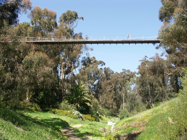
San Diego known for Balboa Park, Mission Bay beaches an of course the pacific ocean beaches has a lot of open space parkland with our canyons that are basically impossible to develop. I can't stress enough how much of an asset these are to city living. The city has done a great job with pedestrian access to these natural open areas.

Maple Canyon is just north of Downtown in Bankers Hill:
https://goo.gl/maps/5eu3R5Rb5ZkV6xbu7
https://goo.gl/maps/c6sncbtJN5pyVbCw7 (Quince St pedestrian bridge looking east)
https://goo.gl/maps/DMBJ6owJ6bv9s57i9 (Quince St. Ped Bridge looking west)

Next to Maple Canyon in the same neighborhood is Arroyo Canyon here's the Spruce Street Suspension Bridge (pedestrian):


All of these images are from just one of the many canyons that run throughout the city of San Diego. All images are from this area, just north of downtown:
https://www.google.com/maps/place/Banker...7ee45269!8m2!3d32.7308025!4d-117.1629493
Reply With Quote
     
     
  #3662  
Old Posted Apr 22, 2022, 7:13 PM
ChiSoxRox's Avatar
ChiSoxRox ChiSoxRox is offline
Registered User
 
Join Date: Mar 2007
Location: Boston, MA
Posts: 2,338
duplicate
__________________
Like the pre-war masonry skyscrapers? Then check out my list of the tallest buildings in 1950.

Last edited by ChiSoxRox; Apr 22, 2022 at 11:53 PM.
Reply With Quote
     
     
  #3663  
Old Posted Apr 22, 2022, 11:52 PM
ChiSoxRox's Avatar
ChiSoxRox ChiSoxRox is offline
Registered User
 
Join Date: Mar 2007
Location: Boston, MA
Posts: 2,338
Quote:
Originally Posted by Steely Dan View Post
Yeah, LA suburbia is some of these most consistently medium-high density suburbia in the nation. There's not a ton of low and ultra-low density sprawl on it's edges dragging the MSA number well below the city like in most other cities.

I'd be curious to see similar city vs. weighted density stats for a place Vegas that is probably even more uniform across the board (Vegas suburbia tends to be quite dense, and city proper Vegas doesn't have the urban core density spikes of LA).
Las Vegas winds up being very similar to its suburbia. The closest tract mapping winds up being 640,389 people, 1600 shy of the actual city (about half a tract's worth).

Las Vegas city: 7,308.8 ppsm

Clark County/Las Vegas MSA: 7,031.7 ppsm

The third densest MSA behaves more like its peers:

Honolulu CDP: 22,990.0 ppsm

Honolulu County/MSA: 12,581.9
__________________
Like the pre-war masonry skyscrapers? Then check out my list of the tallest buildings in 1950.

Last edited by ChiSoxRox; Apr 23, 2022 at 12:05 AM.
Reply With Quote
     
     
  #3664  
Old Posted Apr 23, 2022, 12:05 AM
Steely Dan's Avatar
Steely Dan Steely Dan is offline
devout Pizzatarian
 
Join Date: Jul 2001
Location: Lincoln Square, Chicago
Posts: 30,470
^ just as I suspected. Thanks for computing!

Vegas has to have the flattest density gradient of any major 1M+ MSA.

It's like an entire major metro area built out with a consistent 7,000 ppsm density. Nothing egregiously high, nothing egregiously low, just 500 sq. miles of tightly packed suburban tract homes and then abrupt desert wilderness. it's like the anti-minneapolis.
__________________
"Missing middle" housing can be a marvelous middle ground for many middle class families.

Last edited by Steely Dan; Apr 23, 2022 at 12:24 AM.
Reply With Quote
     
     
  #3665  
Old Posted Apr 23, 2022, 12:37 AM
ChiSoxRox's Avatar
ChiSoxRox ChiSoxRox is offline
Registered User
 
Join Date: Mar 2007
Location: Boston, MA
Posts: 2,338
Quote:
Originally Posted by Steely Dan View Post
^ just as I suspected. Thanks for computing!

Vegas has to have the flattest density gradient of any major 1M+ MSA.

It's like an entire major metro area built out with a consistent 7,000 ppsm density. Nothing egregiously high, nothing egregiously low, just 500 sq. miles of tightly packed suburban tract homes and then abrupt desert wilderness. it's like the anti-minneapolis.
A spreadsheet I have from making the numerical density threshold lists has all of the MSAs by population in each bin of 1000 people per square mile. Here is Las Vegas:

Left column is density bin. First is 0 to 1000 ppsm, second is 1000 to 2000 ppsm, so on. Second column is the population of the MSA in that bin. Vegas is indeed perhaps the flattest such metro.

0 126,576
1 91,951
2 182,783
3 114,542
4 175,593
5 250,593
6 215,058
7 246,083
8 271,481
9 149,291
10 140,289
11 114,517
12 45,741
13 26,909
14 19,161
15 38,318
16 12,863
17 10,611
18
19 6,987
20
21 12,002
22 10,246
23 3,866
24

By contrast, the Twin Cities with the suburban density cliff and the UM tracts:

0 893,053
1 483,736
2 652,542
3 481,756
4 296,589
5 229,308
6 114,352
7 143,292
8 82,454
9 71,285
10 47,632
11 37,216
12 19,914
13 29,521
14 18,449
15
16 10,291
17 12,421
18 9,833
19 3,619
20
21 16,992
22 10,332
23
24 2,746
25
26 7,770
27
28
29 6,524
30
31
32
33
34
35
36
37
38 4,314
39
40
41 4,320
42

Meanwhile, the New York City MSA has quite the long tail:
__________________
Like the pre-war masonry skyscrapers? Then check out my list of the tallest buildings in 1950.

Last edited by ChiSoxRox; Apr 23, 2022 at 12:58 AM. Reason: number instead of percentage might be clearer
Reply With Quote
     
     
  #3666  
Old Posted Apr 27, 2022, 10:24 PM
Yuri's Avatar
Yuri Yuri is offline
Registered User
 
Join Date: Sep 2008
Posts: 6,280
That's for Steely who doesn't like Chicago MSA and its cornfields:

---------------------- 2020 -------- 2010 -------- 2000 -------- 1990 --------- Area --------------- Growth % ---------- Density

CHICAGO --------- 8,977,679 --- 8,835,910 --- 8,568,905 --- 7,727,231 ---- 8,590 km² ---- 1.6% ---- 3.1% --- 10.9% ---- 1,045.1 inh./km²

- Chicago is the whole Cook, Du Page and Lake, IL counties. For the others, I used census "minor civil divisions" as units: Kane without the 1/3 western part (minus 5 divisions), Kendall with only 2 divisions (basically Oswego), McHenry without the western half (minus 9 divisions), Will without the 1/3 southern part (minus 9 divisions), Lake, IN without the 1/3 southern part (minus 3 divisions) and Porter with only 1 division (basically Portage). You can see the maps on citypopulation.de

That's 3,300 sq mi for a 2,700 inh/sq mi density. It's very close to Chicago's urban area. It's a 9 million people city.
__________________
London - São Paulo - Rio de Janeiro - Londrina - Frankfurt
Reply With Quote
     
     
  #3667  
Old Posted Apr 28, 2022, 12:30 AM
Steely Dan's Avatar
Steely Dan Steely Dan is offline
devout Pizzatarian
 
Join Date: Jul 2001
Location: Lincoln Square, Chicago
Posts: 30,470
^ i still prefer the finer grain of the "census tract" over the "minor civil division".

in 2010, the chicago UA had 8,608,208 people on 2,442.8 sq. miles of land.

though the CB splits it off into its own UA, i think a fairly reasonable "not by the letter of the law" case could be made to include the adjacent round lake UA into chicago's UA.

in 2010, the round lake UA had 290,373 people on 152.6 sq. miles of land.

so combined, that would be a "CUA" of 8,898,581 people on 2,595.4 sq. miles of land.

that's a pretty "real deal" picture of chicagoland IMO. granted those are all 2010 #s, but chicagoland only added ~150K last decade, and most of that was in cook county anyway, so the land area of new sprawl is fairly minimal, at least relative to the previous 6 decades of unrelenting cornfield gobbling.
__________________
"Missing middle" housing can be a marvelous middle ground for many middle class families.
Reply With Quote
     
     
  #3668  
Old Posted Apr 28, 2022, 12:43 AM
Yuri's Avatar
Yuri Yuri is offline
Registered User
 
Join Date: Sep 2008
Posts: 6,280
Quote:
Originally Posted by Steely Dan View Post
^ i still prefer the finer grain of the "census tract" than the "minor civil division".

in 2010, the chicago UA had 8,608,208 people on 2,442.8 sq. miles of land.

though the CB splits it off into its own UA, i think a fairly reasonable "not by the letter of the law" case could be made to include the adjacent round lake UA into chicago's UA.

in 2010, the round lake UA had 290,373 people on 152.6 sq. miles of land.

so combined, that would be a "CUA" of 8,898,581 people on 2,595.4 sq. miles of land.

that's a pretty "real deal" picture of chicagoland IMO. granted those are all 2010 #s, but chicagoland only added ~150K last decade, and most of that was in cook county anyway, so the land area of new sprawl is fairly minimal, at least relative to the previous 6 decades of unrelenting cornfield gobbling.
I think minor divisions have more flavour while census tracts are too technical.

Looking at it again, maybe I could have slashed 4 more low density divisions in Will, just south of Joliet and New Lenox, another 2 in McHenry. That alone would cut some 550 km² (210 sq mi) and few thousand people less.

That would bring its size very close to the official UA. Maybe even Portage could go as it's too far away, despite the continuous sprawl all the way there.
__________________
London - São Paulo - Rio de Janeiro - Londrina - Frankfurt
Reply With Quote
     
     
  #3669  
Old Posted Apr 28, 2022, 12:57 AM
Steely Dan's Avatar
Steely Dan Steely Dan is offline
devout Pizzatarian
 
Join Date: Jul 2001
Location: Lincoln Square, Chicago
Posts: 30,470
Quote:
Originally Posted by Yuri View Post
I think minor divisions have more flavour while census tracts are too technical.
While I freely admit that all methods have their shortcomings, we can agree to disagree on this one.

You can continue making up your own boundaries.

And I can continue waiting for the CB to finally fucking release the 2020 UA figures.

In chicagoland's case, the combined Chicago & Round Lake "CUA" will probably be just over 9M people on ~2,700 sq. miles of land.
__________________
"Missing middle" housing can be a marvelous middle ground for many middle class families.

Last edited by Steely Dan; Apr 28, 2022 at 5:14 AM.
Reply With Quote
     
     
  #3670  
Old Posted Apr 28, 2022, 5:03 AM
ChiSoxRox's Avatar
ChiSoxRox ChiSoxRox is offline
Registered User
 
Join Date: Mar 2007
Location: Boston, MA
Posts: 2,338
*Maybe* this weekend I can try my hand at a 2020 UA figure for Chicago using the (clear as mud) Census methology.
__________________
Like the pre-war masonry skyscrapers? Then check out my list of the tallest buildings in 1950.
Reply With Quote
     
     
  #3671  
Old Posted Apr 28, 2022, 3:46 PM
Gantz Gantz is offline
Registered User
 
Join Date: Mar 2013
Posts: 778
Quote:
Originally Posted by ChiSoxRox View Post
A spreadsheet I have from making the numerical density threshold lists has all of the MSAs by population in each bin of 1000 people per square mile. Here is Las Vegas:

Left column is density bin. First is 0 to 1000 ppsm, second is 1000 to 2000 ppsm, so on. Second column is the population of the MSA in that bin. Vegas is indeed perhaps the flattest such metro.
Are Yorkville towers really that dense or is that some kind of issue with border cut off points? They do not look like anything special in person in NYC context, typical tower in the park development.
Reply With Quote
     
     
  #3672  
Old Posted Apr 28, 2022, 4:05 PM
Crawford Crawford is offline
Registered User
 
Join Date: Nov 2003
Location: Brooklyn, NYC/Polanco, DF
Posts: 34,897
Quote:
Originally Posted by Gantz View Post
Are Yorkville towers really that dense or is that some kind of issue with border cut off points? They do not look like anything special in person in NYC context, typical tower in the park development.
Are you talking about Yorkville in Manhattan? Like the Upper East Side mini-neighborhood?

I can't think of any tower in the park developments in Yorkville. It's pretty much entirely newer urban towers or older tenements. It's almost certainly the densest residential neighborhood in U.S./Canada.
Reply With Quote
     
     
  #3673  
Old Posted Apr 28, 2022, 4:23 PM
iheartthed iheartthed is offline
Registered User
 
Join Date: Oct 2009
Location: New York
Posts: 12,071
Quote:
Originally Posted by Gantz View Post
Are Yorkville towers really that dense or is that some kind of issue with border cut off points? They do not look like anything special in person in NYC context, typical tower in the park development.
Looks like it's populated enough to be its own census tract. It's not anything special, but when a development is its own census tract it will look extremely dense. This would be the case in any city.
Reply With Quote
     
     
  #3674  
Old Posted Apr 28, 2022, 5:31 PM
Steely Dan's Avatar
Steely Dan Steely Dan is offline
devout Pizzatarian
 
Join Date: Jul 2001
Location: Lincoln Square, Chicago
Posts: 30,470
Quote:
Originally Posted by iheartthed View Post
Looks like it's populated enough to be its own census tract. It's not anything special, but when a development is its own census tract it will look extremely dense. This would be the case in any city.
yeah, in some cities the census bureau has some extremely tiny odd-ball census tracts that consist of just a couple highrise residential towers that can produce some outlandish density results.

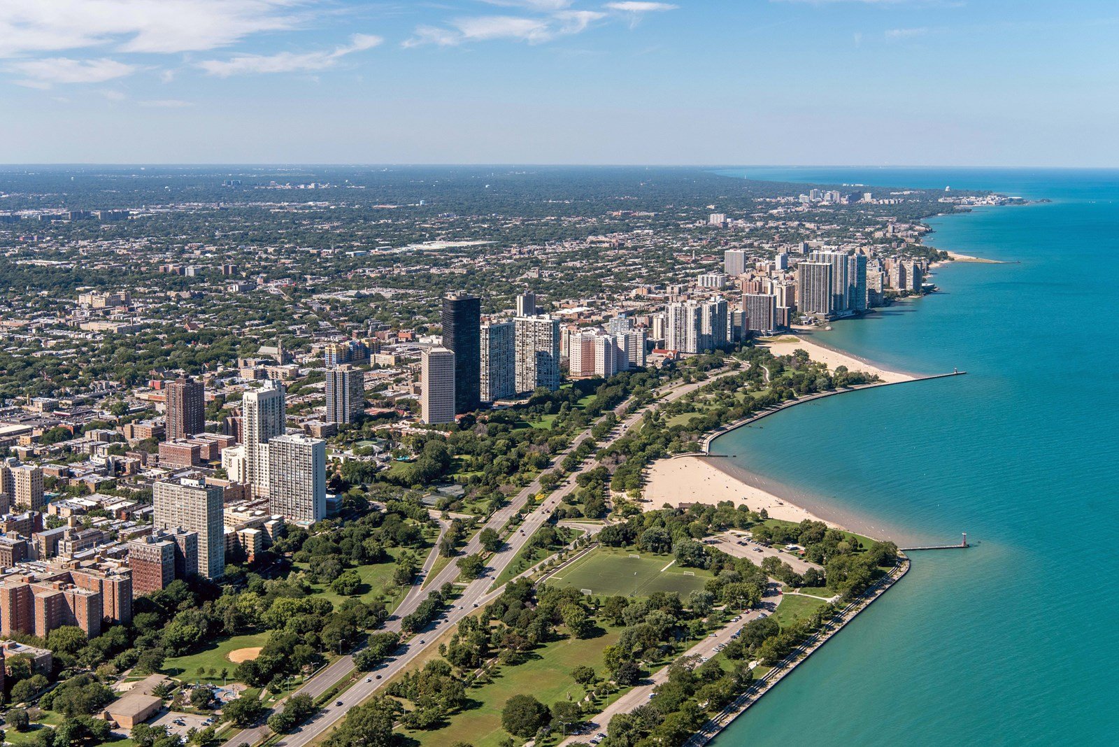
there's one of those up in chicago's edgewater neighborhood. census tract 307.02 has a population density of 270,944.7 ppsm!

but in reality, the entire tract consists of only the tall black Miesian skyscraper pictured below and the one immediately north of it. that's it.

my mom & dad actually live in the tall black building, so i'm quite familiar with the area. it's just a statistical quirk from a tiny little fly-speck tract.


Source: https://www.flatslife.com/blog/2019/09/05/lady-louise39s-introduction-to-chicago-neighborhoods/
__________________
"Missing middle" housing can be a marvelous middle ground for many middle class families.

Last edited by Steely Dan; Apr 28, 2022 at 8:19 PM.
Reply With Quote
     
     
  #3675  
Old Posted Apr 28, 2022, 5:33 PM
Crawford Crawford is offline
Registered User
 
Join Date: Nov 2003
Location: Brooklyn, NYC/Polanco, DF
Posts: 34,897
Edgewater, at least along the lakefront, is an unusually dense slice of Chicago, however. It isn't just census tract weirdness.

And Yorkville is an unusually dense slice of NYC. They're both outliers, even in their immediate neighborhood context.
Reply With Quote
     
     
  #3676  
Old Posted Apr 28, 2022, 5:40 PM
Steely Dan's Avatar
Steely Dan Steely Dan is offline
devout Pizzatarian
 
Join Date: Jul 2001
Location: Lincoln Square, Chicago
Posts: 30,470
Quote:
Originally Posted by Crawford View Post
Edgewater, at least along the lakefront, is an unusually dense slice of Chicago, however. It isn't just census tract weirdness.
well, the other lakefront tracts in edgwater around my parents' building are more normal-sized and fall in the 40,000 - 80,000 ppsm range.

so yeah, it's a very densely populated place by US standards, but that 270,000 ppsm ridiculousness stems from an extremely tiny odd-ball census tract.
__________________
"Missing middle" housing can be a marvelous middle ground for many middle class families.

Last edited by Steely Dan; Apr 28, 2022 at 8:15 PM.
Reply With Quote
     
     
  #3677  
Old Posted May 11, 2022, 7:50 PM
ChiSoxRox's Avatar
ChiSoxRox ChiSoxRox is offline
Registered User
 
Join Date: Mar 2007
Location: Boston, MA
Posts: 2,338
Does anyone know where one could find the land area of census subdivisions? I found the TIGER site, do I need to pull the ZIP files and find a land area column?

I am wanting to recalculate the weighted densities using census blocks, to get a far finer measurement than the census tract numbers. I have the population of each block off the Census Data Explorer, but I can't find the land area of each block.

(To give a sense of the improved granularity: Cook County, Illinois is 1,332 tracts but 83,018 blocks!

Edit: Found the Gazetteer files which have the areas for census tracts and other subdivisions, but not block groups or blocks. Looks like that would be a massive GIS undertaking to scrape the areas for the individual blocks.

Although it seems like we'll get the 2020 urban area delineations by October, as those will be included in this year's gazetteer files.
__________________
Like the pre-war masonry skyscrapers? Then check out my list of the tallest buildings in 1950.
Reply With Quote
     
     
  #3678  
Old Posted May 11, 2022, 8:16 PM
Yuri's Avatar
Yuri Yuri is offline
Registered User
 
Join Date: Sep 2008
Posts: 6,280
Quote:
Originally Posted by ChiSoxRox View Post
Does anyone know where one could find the land area of census subdivisions? I found the TIGER site, do I need to pull the ZIP files and find a land area column?

I am wanting to recalculate the weighted densities using census blocks, to get a far finer measurement than the census tract numbers. I have the population of each block off the Census Data Explorer, but I can't find the land area of each block.

(To give a sense of the improved granularity: Cook County, Illinois is 1,332 tracts but 83,018 blocks!

Edit: Found the Gazetteer files which have the areas for census tracts and other subdivisions, but not block groups or blocks. Looks like that would be a massive GIS undertaking to scrape the areas for the individual blocks.

Although it seems like we'll get the 2020 urban area delineations by October, as those will be included in this year's gazetteer files.
I thought Census tracts were the smallest divisions.
__________________
London - São Paulo - Rio de Janeiro - Londrina - Frankfurt
Reply With Quote
     
     
  #3679  
Old Posted May 11, 2022, 8:19 PM
Steely Dan's Avatar
Steely Dan Steely Dan is offline
devout Pizzatarian
 
Join Date: Jul 2001
Location: Lincoln Square, Chicago
Posts: 30,470
Quote:
Originally Posted by ChiSoxRox View Post

Although it seems like we'll get the 2020 urban area delineations by October
I want to believe that's true.

But I'll believe it when I see it.
__________________
"Missing middle" housing can be a marvelous middle ground for many middle class families.
Reply With Quote
     
     
  #3680  
Old Posted May 11, 2022, 8:23 PM
ChiSoxRox's Avatar
ChiSoxRox ChiSoxRox is offline
Registered User
 
Join Date: Mar 2007
Location: Boston, MA
Posts: 2,338
Quote:
Originally Posted by Yuri View Post
I thought Census tracts were the smallest divisions.
Tracts are divided into block groups, which in turn are divided into blocks.

However, for urban areas, sub-tract divisions get *very* numerous very quickly, so tracts strike a decent balance between granularity and amount of data.

__________________
Like the pre-war masonry skyscrapers? Then check out my list of the tallest buildings in 1950.
Reply With Quote
     
     
This discussion thread continues

Use the page links to the lower-right to go to the next page for additional posts
 
 
Reply

Go Back   SkyscraperPage Forum > Discussion Forums > City Discussions
Forum Jump


Forum Jump


All times are GMT. The time now is 8:52 AM.


Powered by vBulletin® Version 3.8.7
Copyright ©2000 - 2026, vBulletin Solutions, Inc.