HomeDiagramsDatabaseMapsForum About
     

Go Back   SkyscraperPage Forum > Regional Sections > Canada


Reply

 
Thread Tools Display Modes
     
     
  #1081  
Old Posted Dec 21, 2020, 5:39 PM
Denscity Denscity is offline
Registered User
 
Join Date: Jun 2008
Location: Laramidia
Posts: 12,781
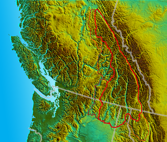
Wish I had a topo map to show of my region. We've got not 1 but 4 mountain ranges including half the Rockies.
And the valley Castlegar sits in compared to our highest mountain top is a huge difference.
__________________
Peak SSP:

28C is hotter than 42C
Vancouver is not on the ocean but Quebec City is.
Reply With Quote
     
     
  #1082  
Old Posted Dec 21, 2020, 6:26 PM
shreddog shreddog is offline
Beer me Captain
 
Join Date: Sep 2003
Location: Taking a Pis fer all of ya
Posts: 5,524
Quote:
Originally Posted by Denscity View Post
Wish I had a topo map to show of my region. We've got not 1 but 4 mountain ranges including half the Rockies.
And the valley Castlegar sits in compared to our highest mountain top is a huge difference.
Sorry but no. First, the Rockies only exist east of the Columbia trench, Roosvile to Valemont. Secondly, Castlegar completely exists within the Columbia mountains; to the north and east is the Selkirk range and to the south and west is the Monshee range.

Impressive mountains definitely, but only 2 ranges and no Rockies. Unless you have excellent vision like Michelle Jean!

__________________
Leaving a Pis fer all of ya!

Do something about your future.
Reply With Quote
     
     
  #1083  
Old Posted Dec 21, 2020, 7:02 PM
lio45 lio45 is offline
BANNED
 
Join Date: Aug 2007
Location: Quebec
Posts: 44,901
Quote:
Originally Posted by MonctonRad View Post


We do (I do at least)

Here's a topographical map of Moncton:


I realize the relief is exaggerated, but it is meaningful nonetheless. It allows you to see the breadth of the Petitcodiac River Valley, and explains why the river takes that 90 degree bend at Moncton, heading WSW rather than NNW.
It would explain that 90 degree turn perfectly if it flowed the other way, but the way I see it, this topographical map doesn't really (at that level of detail) show why the river doesn't just continue on its way to an outlet that would be north of Shediac (where that "Y" shaped river is).
Reply With Quote
     
     
  #1084  
Old Posted Dec 21, 2020, 7:21 PM
Denscity Denscity is offline
Registered User
 
Join Date: Jun 2008
Location: Laramidia
Posts: 12,781
Quote:
Originally Posted by shreddog View Post
Sorry but no. First, the Rockies only exist east of the Columbia trench, Roosvile to Valemont. Secondly, Castlegar completely exists within the Columbia mountains; to the north and east is the Selkirk range and to the south and west is the Monshee range.

Impressive mountains definitely, but only 2 ranges and no Rockies. Unless you have excellent vision like Michelle Jean!

I didn't mean the Castlegar region i meant the entire Kootenay region.
Big White to Field.
Some of those maps included entire provinces.
__________________
Peak SSP:

28C is hotter than 42C
Vancouver is not on the ocean but Quebec City is.
Reply With Quote
     
     
  #1085  
Old Posted Dec 21, 2020, 7:47 PM
MonctonRad's Avatar
MonctonRad MonctonRad is online now
Wildcats Rule!!
 
Join Date: Jun 2008
Location: Moncton NB
Posts: 41,157
Quote:
Originally Posted by shreddog View Post
Impressive mountains definitely, but only 2 ranges and no Rockies. Unless you have excellent vision like Michelle Jean!
Or Sarah Palin - "I can see Russia from my house!"
__________________
Go 'Cats Go
Reply With Quote
     
     
  #1086  
Old Posted Dec 21, 2020, 7:48 PM
MonctonRad's Avatar
MonctonRad MonctonRad is online now
Wildcats Rule!!
 
Join Date: Jun 2008
Location: Moncton NB
Posts: 41,157
Quote:
Originally Posted by lio45 View Post
It would explain that 90 degree turn perfectly if it flowed the other way, but the way I see it, this topographical map doesn't really (at that level of detail) show why the river doesn't just continue on its way to an outlet that would be north of Shediac (where that "Y" shaped river is).
It's the Petitcodiac. It's tidal. It flow both ways.
__________________
Go 'Cats Go
Reply With Quote
     
     
  #1087  
Old Posted Dec 21, 2020, 10:52 PM
davidivivid davidivivid is online now
Registered User
 
Join Date: Jul 2010
Location: Ville de Québec City
Posts: 3,066
__________________
"I went on a diet, swore off drinking and heavy eating, and in fourteen days I lost two weeks" Joe E. Lewis
Reply With Quote
     
     
  #1088  
Old Posted Dec 21, 2020, 11:36 PM
Djeffery's Avatar
Djeffery Djeffery is offline
Registered User
 
Join Date: Oct 2017
Location: London
Posts: 6,292
Quote:
Originally Posted by MonctonRad View Post
It's the Petitcodiac. It's tidal. It flow both ways.
As is the Shediac River (my parents live beside it), although the tidal flow only goes maybe 3 or 4 miles inland and doesn't create a bore like the Petitcodiac does or did anyway.
Reply With Quote
     
     
  #1089  
Old Posted Dec 21, 2020, 11:37 PM
MolsonExport's Avatar
MolsonExport MolsonExport is online now
Touching grass everyday.
 
Join Date: Oct 2003
Location: Otisburgh
Posts: 51,427
Quote:
Originally Posted by davidivivid View Post
Awesome
__________________
The whole problem with the world is that fools and fanatics are always so certain of themselves, and wiser people so full of doubts. (Bertrand Russell). Sweet Loretta fart thought she was a cleaner, but she was a frying pan. (John Lennon)
Reply With Quote
     
     
  #1090  
Old Posted Dec 22, 2020, 12:21 AM
MonctonRad's Avatar
MonctonRad MonctonRad is online now
Wildcats Rule!!
 
Join Date: Jun 2008
Location: Moncton NB
Posts: 41,157
Quote:
Originally Posted by Djeffery View Post
As is the Shediac River (my parents live beside it), although the tidal flow only goes maybe 3 or 4 miles inland and doesn't create a bore like the Petitcodiac does or did anyway.
Still does. They opened the floodgate under the causeway permanently about a decade back, and this instantly doubled the size of the bore.

Next year they are replacing the causeway with a bridge, which should double the width of the river channel. The hope is the tidal bore will be fully restored at that point.
__________________
Go 'Cats Go
Reply With Quote
     
     
  #1091  
Old Posted Dec 22, 2020, 12:56 AM
Architype's Avatar
Architype Architype is offline
♒︎ verified human
 
Join Date: Mar 2004
Location: 🍁 Canada
Posts: 14,067
Quote:
Originally Posted by Bishop2047 View Post


NS and PEI
...
I'd forgotten that Nova Scotia has mountains, you don't hear many references to mountains in NS.
Reply With Quote
     
     
  #1092  
Old Posted Dec 22, 2020, 1:07 AM
Acajack's Avatar
Acajack Acajack is offline
Gros Méchant Loup
 
Join Date: Aug 2006
Location: Province 2, Canadian Empire
Posts: 72,949
Quote:
Originally Posted by Architype View Post
I'd forgotten that Nova Scotia has mountains, you don't hear many references to mountains in NS.
Cabot Trail?
__________________
Loin des yeux, loin du coeur.
Reply With Quote
     
     
  #1093  
Old Posted Dec 22, 2020, 1:14 AM
Architype's Avatar
Architype Architype is offline
♒︎ verified human
 
Join Date: Mar 2004
Location: 🍁 Canada
Posts: 14,067
Quote:
Originally Posted by Acajack View Post
Cabot Trail?
That's highlands, not named as mountain ranges I think. The mountain ranges are the Cobequid and the South Mts., as seen on the map.
Reply With Quote
     
     
  #1094  
Old Posted Dec 22, 2020, 1:33 AM
Djeffery's Avatar
Djeffery Djeffery is offline
Registered User
 
Join Date: Oct 2017
Location: London
Posts: 6,292
Quote:
Originally Posted by MonctonRad View Post
Still does. They opened the floodgate under the causeway permanently about a decade back, and this instantly doubled the size of the bore.

Next year they are replacing the causeway with a bridge, which should double the width of the river channel. The hope is the tidal bore will be fully restored at that point.
That's good to hear. It was never anything special when I was younger, my mom used to tell me about it when she was a teenager.
Reply With Quote
     
     
  #1095  
Old Posted Dec 22, 2020, 5:22 AM
MonctonRad's Avatar
MonctonRad MonctonRad is online now
Wildcats Rule!!
 
Join Date: Jun 2008
Location: Moncton NB
Posts: 41,157
Quote:
Originally Posted by Djeffery View Post
That's good to hear. It was never anything special when I was younger, my mom used to tell me about it when she was a teenager.
They surf on the tidal bore now...........
__________________
Go 'Cats Go
Reply With Quote
     
     
  #1096  
Old Posted Dec 22, 2020, 12:45 PM
Acajack's Avatar
Acajack Acajack is offline
Gros Méchant Loup
 
Join Date: Aug 2006
Location: Province 2, Canadian Empire
Posts: 72,949
Quote:
Originally Posted by Architype View Post
That's highlands, not named as mountain ranges I think. The mountain ranges are the Cobequid and the South Mts., as seen on the map.
The highest point in Nova Scotia is in the Cape Breton Highlands, which are part of the Appalachian Mountain chain I am pretty sure.
__________________
Loin des yeux, loin du coeur.
Reply With Quote
     
     
  #1097  
Old Posted Dec 22, 2020, 2:00 PM
Architype's Avatar
Architype Architype is offline
♒︎ verified human
 
Join Date: Mar 2004
Location: 🍁 Canada
Posts: 14,067
You're correct, my meaning was actually just in reference to features actually labeled as "mountains" on the map. I am pretty familiar with NS, having spent some years there. So are the highlands technically mountains? I guess so but they are not named as such, perhaps a technicality. NL's Long Range Mountains are also an extension of the Appalachians.

Quote:
The Cape Breton Highlands (French: Plateau du Cap-Breton), commonly called the Highlands, refer to a highland or mountainous plateau across the northern part of Cape Breton Island in the Canadian province of Nova Scotia.

Considered an extension of the Appalachian mountain chain, the Highlands comprise the northern portions of Inverness and Victoria counties.
https://en.wikipedia.org/wiki/Cape_Breton_Highlands
Reply With Quote
     
     
  #1098  
Old Posted Dec 22, 2020, 4:50 PM
someone123's Avatar
someone123 someone123 is online now
hähnchenbrüstfiletstüc
 
Join Date: Nov 2001
Location: Vancouver
Posts: 35,889
There are lots of named mountains on Cape Breton, e.g. Franey Mountain. It is not all plateau, though some of it is.

Around mainland NS there are the South and North Mountains, etc. Most of them look more like rounded hills.
Reply With Quote
     
     
  #1099  
Old Posted Dec 22, 2020, 5:23 PM
shreddog shreddog is offline
Beer me Captain
 
Join Date: Sep 2003
Location: Taking a Pis fer all of ya
Posts: 5,524
Quote:
Originally Posted by Denscity View Post
I didn't mean the Castlegar region i meant the entire Kootenay region.
...
included entire provinces.
So if your saying your region is the Kootenays, we don't you just post a map of Columbia mtns which pretty much aligns with it?

__________________
Leaving a Pis fer all of ya!

Do something about your future.
Reply With Quote
     
     
  #1100  
Old Posted Dec 22, 2020, 6:29 PM
FrAnKs's Avatar
FrAnKs FrAnKs is offline
Registered User
 
Join Date: Jul 2005
Location: Ville de Québec / Quebec city
Posts: 5,932
Quote:
Originally Posted by Architype View Post
I'd forgotten that Nova Scotia has mountains, you don't hear many references to mountains in NS.
Really? If there is something I know from Nova Scotia, is it's not flat.
__________________
PROVINCE OF QUEBEC ==> 9 050 000
MONTREAL METRO ==> 4 600 000
QUEBEC CITY METRO ==> 900 000
Reply With Quote
     
     
This discussion thread continues

Use the page links to the lower-right to go to the next page for additional posts
 
 
Reply

Go Back   SkyscraperPage Forum > Regional Sections > Canada
Forum Jump


Forum Jump


All times are GMT. The time now is 5:08 PM.


Powered by vBulletin® Version 3.8.7
Copyright ©2000 - 2026, vBulletin Solutions, Inc.