HomeDiagramsDatabaseMapsForum About
     

Go Back   SkyscraperPage Forum > Regional Sections > Canada > Ontario > Ottawa-Gatineau > Transportation


View Poll Results: What should be given priority for LRT Stage 3?
Rural Rail 3 2.29%
Barrhaven 14 10.69%
South East 0 0%
Kanata 32 24.43%
Gatineau 19 14.50%
Orleans 0 0%
Bank St Subway 37 28.24%
Montreal Road 23 17.56%
Other 3 2.29%
Voters: 131. You may not vote on this poll

Reply

 
Thread Tools Display Modes
     
     
  #381  
Old Posted Apr 22, 2020, 2:28 PM
JHikka's Avatar
JHikka JHikka is offline
ハルウララ
 
Join Date: Jul 2009
Location: Toronto
Posts: 12,853
Quote:
Originally Posted by Acajack View Post
Is this type of power shift really in the offing?
I doubt it. For every new condo on Bank there's two new subdivisions in Kanata and Orleans. Of course, Ottawa's downtown is densifying, but I don't think the proportion is shifting any meaningful amount towards urban residents.
Reply With Quote
     
     
  #382  
Old Posted Apr 22, 2020, 2:32 PM
Acajack's Avatar
Acajack Acajack is offline
Gros Méchant Loup
 
Join Date: Aug 2006
Location: Province 2, Canadian Empire
Posts: 72,949
Quote:
Originally Posted by JHikka View Post
I doubt it. For every new condo on Bank there's two new subdivisions in Kanata and Orleans. Of course, Ottawa's downtown is densifying, but I don't think the proportion is shifting any meaningful amount towards urban residents.
Yeah. My guess is that the political power relationships and weighting will remain roughly the same.
__________________
Loin des yeux, loin du coeur.
Reply With Quote
     
     
  #383  
Old Posted Apr 22, 2020, 6:53 PM
Truenorth00 Truenorth00 is offline
Registered User
 
Join Date: May 2017
Posts: 28,809
Quote:
Originally Posted by Acajack View Post
Yeah. My guess is that the political power relationships and weighting will remain roughly the same.
I'd argue what really hurts Ottawa is the areas inside the Greenbelt that are also very suburban. Most of those voters aren't thinking like urbanites.
Reply With Quote
     
     
  #384  
Old Posted Apr 22, 2020, 7:12 PM
CityTech CityTech is offline
Registered User
 
Join Date: May 2016
Location: Ottawa
Posts: 2,798
Quote:
Originally Posted by Truenorth00 View Post
I'd argue what really hurts Ottawa is the areas inside the Greenbelt that are also very suburban. Most of those voters aren't thinking like urbanites.
Many of these neighbourhoods also really need to be urbanized. Stretches like Merivale from Baseline-Carling, Carling between Lincoln Fields and Westgate, Montreal east of St. Laurent, St. Laurent between Elmvale and Montreal, Bank between Billings Bridge and South Keys, are roads that really should be redeveloped as urban mainstreets.
Reply With Quote
     
     
  #385  
Old Posted Apr 22, 2020, 7:24 PM
J.OT13's Avatar
J.OT13 J.OT13 is offline
Moderator
 
Join Date: Mar 2012
Location: Ottawa
Posts: 28,594
And these mid-century suburban neighborhoods have sub-par transit.
Reply With Quote
     
     
  #386  
Old Posted Apr 22, 2020, 7:32 PM
On Edge On Edge is offline
Registered User
 
Join Date: Oct 2012
Posts: 159
Quote:
Originally Posted by CityTech View Post
Many of these neighbourhoods also really need to be urbanized. Stretches like Merivale from Baseline-Carling, Carling between Lincoln Fields and Westgate, Montreal east of St. Laurent, St. Laurent between Elmvale and Montreal, Bank between Billings Bridge and South Keys, are roads that really should be redeveloped as urban mainstreets.
Hard to see how that can be good under the present circumstances as these are major commuting routes. Bank Street is basically a key north-south artery and cannot be mainstreeted until alternatives pop up. Which will be never.
Reply With Quote
     
     
  #387  
Old Posted Apr 22, 2020, 8:39 PM
TransitZilla TransitZilla is offline
Registered User
 
Join Date: Dec 2006
Posts: 2,797
Quote:
Originally Posted by On Edge View Post
Hard to see how that can be good under the present circumstances as these are major commuting routes. Bank Street is basically a key north-south artery and cannot be mainstreeted until alternatives pop up. Which will be never.
The reconstruction of Bank Street coming up in the next few years will go a long way to making it a more welcoming street, and development will very likely follow.
Reply With Quote
     
     
  #388  
Old Posted Apr 22, 2020, 9:31 PM
CityTech CityTech is offline
Registered User
 
Join Date: May 2016
Location: Ottawa
Posts: 2,798
Quote:
Originally Posted by On Edge View Post
Hard to see how that can be good under the present circumstances as these are major commuting routes. Bank Street is basically a key north-south artery and cannot be mainstreeted until alternatives pop up. Which will be never.
The Airport parkway runs basically parallel to Bank in the section I'm talking about.

EDIT: It would be nice to, as part of a broad redevelopment of the South Keys area, break up Bank at Hunt Club so the southern part feeds into the airport parkway instead. Something like this (behold my MS Paint artistry):
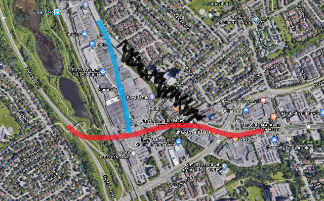


The red and blue are the two halves of Bank. The black X'ed out part of the road would be removed. In the resulting triangle, you'd create a nice space for high rise neighbourhood to be built. Moreover, by cutting the northern part of Bank off from the suburban traffic to the south (from Blossom Park, Finley Creek, Leitrim, Riverside South, etc), you'd significantly reduce the importance of the part of Bank between Billings & South Keys as a commuter roadway and pave the way for narrowing and urbanization of it. Basically separate the urban roadway from the suburban commuter roadway.

The airport parkway would have to be widened north of Hunt Club to accept this amount of traffic (this is planned anyway).

Further north, someone else on here once mentioned (IIRC this was years ago) the idea of breaking up the Airport Parkway from Bronson by building a new road under/over/adjacent to the Trillium Line to carry the Airport Parkway across Dows Lake to feed into Booth/Rochester instead; these two projects would go well together--would create a good north-south traffic route and would also have the perk of freeing up both Bank north of Hunt Club AND Bronson for better urbanization.


Last edited by CityTech; Apr 22, 2020 at 9:47 PM.
Reply With Quote
     
     
  #389  
Old Posted Apr 22, 2020, 9:44 PM
OCCheetos OCCheetos is offline
Registered User
 
Join Date: Aug 2017
Posts: 2,104
Quote:
Originally Posted by On Edge View Post
Hard to see how that can be good under the present circumstances as these are major commuting routes. Bank Street is basically a key north-south artery and cannot be mainstreeted until alternatives pop up. Which will be never.
I feel like this was part of the push for Stage 2 South. Specifically with the Park and Rides.
Reply With Quote
     
     
  #390  
Old Posted Apr 22, 2020, 10:25 PM
J.OT13's Avatar
J.OT13 J.OT13 is offline
Moderator
 
Join Date: Mar 2012
Location: Ottawa
Posts: 28,594
Sorry City Tech, but there's nothing I hate more than splitting roadways, forming multiple roadways of the same name.

Somehow separating Bronson from the Airport Parkway, that I find interesting. When it goes over the Trillium Line, I would have it go all the way up to Albert, with on/off ramps at the Queensway and normal intersections wherever it crosses streets and pedestrian bridges.

If ever that was built (basically a boulevard version of the Champagne expressway), then we could narrow/urbanize Bank all the way to Hunt Club.
Reply With Quote
     
     
  #391  
Old Posted Apr 23, 2020, 12:59 PM
Acajack's Avatar
Acajack Acajack is offline
Gros Méchant Loup
 
Join Date: Aug 2006
Location: Province 2, Canadian Empire
Posts: 72,949
Quote:
Originally Posted by swimmer_spe View Post
I guess it depends on your goals. If your goal is to bring higher order transit to as many people as possible, then, low hanging fruit is the way to go, as it is usually cheaper upfront.

Now, if your goal is to bring the most amount of higher order transit to the paces that really need it, then you are going to have problems.

Look at Calgary and Edmonton for example. One spent money burying the line downtown, one did not. One has a longer system, one does not.

With Phase 2 already underway, and with a stimulus package coming, we could see all the low hanging fruit gobbled up. Then it would be the needed services that get built, not the easy ones.
It's not often stated publicly, but I think that behind the scenes implementing some form of higher order transit on Rideau St-Montreal Rd or Bank St is seen as too complicated.

Which got me thinking that the last time I was in Rome I stayed in Trastavere which is a cool area of inner Rome where they inserted a new surface tram line in.... 1998. Along the main street of the district.

Now, I am not saying that they should shoehorn a tram line into the Glebe along Bank St (which is actually pretty narrow), but surely there are options. I have mentioned the Queen Elizabeth Dr corridor before.

As for Rideau-Montreal, that entire stretch is of comparable width to the street in Rome I am talking about, so it wouldn't be too difficult to implement there.
__________________
Loin des yeux, loin du coeur.
Reply With Quote
     
     
  #392  
Old Posted Apr 23, 2020, 1:29 PM
Proof Sheet Proof Sheet is offline
Registered User
 
Join Date: May 2009
Posts: 2,985
Quote:
Originally Posted by Acajack View Post
It's not often stated publicly, but I think that behind the scenes implementing some form of higher order transit on Rideau St-Montreal Rd or Bank St is seen as too complicated.

Which got me thinking that the last time I was in Rome I stayed in Trastavere which is a cool area of inner Rome where they inserted a new surface tram line in.... 1998. Along the main street of the district.

Now, I am not saying that they should shoehorn a tram line into the Glebe along Bank St (which is actually pretty narrow), but surely there are options. I have mentioned the Queen Elizabeth Dr corridor before.

As for Rideau-Montreal, that entire stretch is of comparable width to the street in Rome I am talking about, so it wouldn't be too difficult to implement there.

Look what they did in Nice

https://goo.gl/maps/YzHgH2isakYyy5kL8

I visited this area in 2016/17 when it looked like this.

https://goo.gl/maps/xpfSv2Xzi4X6cEBS7

and this is what it looked like before.

https://goo.gl/maps/vJ81uLnTuEBLC9kp7
Reply With Quote
     
     
  #393  
Old Posted Apr 23, 2020, 1:35 PM
Acajack's Avatar
Acajack Acajack is offline
Gros Méchant Loup
 
Join Date: Aug 2006
Location: Province 2, Canadian Empire
Posts: 72,949
Quote:
Originally Posted by Proof Sheet View Post
Look what they did in Nice

https://goo.gl/maps/YzHgH2isakYyy5kL8

I visited this area in 2016/17 when it looked like this.

https://goo.gl/maps/xpfSv2Xzi4X6cEBS7

and this is what it looked like before.

https://goo.gl/maps/vJ81uLnTuEBLC9kp7
They lost some nice palm trees in the process but other than that it's great for the city.

Most of the third-tier cities in France have inserted tramways along major streets in their inner cities.

Every single one AFAIK has been a tremendous success.
__________________
Loin des yeux, loin du coeur.
Reply With Quote
     
     
  #394  
Old Posted Apr 24, 2020, 2:48 AM
TheMatth69 TheMatth69 is offline
Registered User
 
Join Date: Apr 2019
Posts: 158
Quote:
Originally Posted by Acajack View Post
They lost some nice palm trees in the process but other than that it's great for the city.

Most of the third-tier cities in France have inserted tramways along major streets in their inner cities.

Every single one AFAIK has been a tremendous success.
I talked about that a few months back, Nice was actually a really interesting project, since they basically did the same thing as us. They converted their BRT into an LRT. The train runs between the airport and the west of downtown on what used to be a BRT stretch. Than the trains go underground for 5 stations, until they emerge in the port where the line ends. Other fun fact they opened their line in "sections", they opened the outside section first (took 2.5 years to complete) then opened the two first stations of the Tunnel in 2018, then opened the full line in fall 2019.

Last edited by TheMatth69; Apr 24, 2020 at 6:44 AM.
Reply With Quote
     
     
  #395  
Old Posted Apr 24, 2020, 2:56 PM
CityTech CityTech is offline
Registered User
 
Join Date: May 2016
Location: Ottawa
Posts: 2,798
A nice urban tram-style LRT route across the central city could be:

*Starting at Blair station
*Travel north on Blair in a new ROW built on the west side of Blair (using the federal property)
*Cut across the NRC property (lots of empty fields and forests that can be used) to the intersection of Bathgate & Den Haag
*Proceed on Den Haag (serving La Cite) to Montreal Road at Montfort - if necessary, some widening could be done to create a tram ROW as Den Haag has no driveways and a pretty wide buffer zone separating the road from the sidewalks and property lines
*Follow Montreal/Rideau down to Rideau station - there's bus lanes already, so enough room for both 2 car lanes and 2 tran lanes
*From Rideau, head down Elgin - have segregated tram and car lanes down to about Nepean (where the road narrows). From Nepean down to Argyle, have Elgin be a European-style tramway and pedestrian roadway, with no cars
*From Elgin, head down the QED, which would be turned into a tramway and closed to traffic, to reach Lansdowne and Carling station
*Proceed down Carling to Lincoln Fields

Much of this could have been done in conjunction with the ongoing/soon-to-be-started rebuilds of Elgin and Montreal.
Reply With Quote
     
     
  #396  
Old Posted Apr 24, 2020, 3:59 PM
lrt's friend lrt's friend is offline
Registered User
 
Join Date: Dec 2006
Posts: 12,750
Quote:
Originally Posted by Proof Sheet View Post
Look what they did in Nice

https://goo.gl/maps/YzHgH2isakYyy5kL8

I visited this area in 2016/17 when it looked like this.

https://goo.gl/maps/xpfSv2Xzi4X6cEBS7

and this is what it looked like before.

https://goo.gl/maps/vJ81uLnTuEBLC9kp7
It would be a bigger challenge on Bank because there are only 4 lanes. This shows at least 6 lanes originally so comparable to Rideau.
Reply With Quote
     
     
  #397  
Old Posted Apr 24, 2020, 4:07 PM
lrt's friend lrt's friend is offline
Registered User
 
Join Date: Dec 2006
Posts: 12,750
Quote:
Originally Posted by Acajack View Post
It's not often stated publicly, but I think that behind the scenes implementing some form of higher order transit on Rideau St-Montreal Rd or Bank St is seen as too complicated.

Which got me thinking that the last time I was in Rome I stayed in Trastavere which is a cool area of inner Rome where they inserted a new surface tram line in.... 1998. Along the main street of the district.

Now, I am not saying that they should shoehorn a tram line into the Glebe along Bank St (which is actually pretty narrow), but surely there are options. I have mentioned the Queen Elizabeth Dr corridor before.

As for Rideau-Montreal, that entire stretch is of comparable width to the street in Rome I am talking about, so it wouldn't be too difficult to implement there.
A Queen Elizabeth routing bypasses both the Elgin and Bank commercial strips, which I would argue that we would want to support in our planning towards the future and further densify. If we are going to the expense of building a tramway or even more so, a subway, it better support our commercial destinations to a max. After the Confederation Line is completed, which is mainly a commuter route, future urban routes need to go through destinations and not around destinations. I would even argue that the South Orleans Transitway is next to useless for our future, when an Innes corridor would be much more worthwhile, as current bus routes already suggest.
Reply With Quote
     
     
  #398  
Old Posted Apr 24, 2020, 4:23 PM
lrt's friend lrt's friend is offline
Registered User
 
Join Date: Dec 2006
Posts: 12,750
Quote:
Originally Posted by CityTech View Post
The Airport parkway runs basically parallel to Bank in the section I'm talking about.

EDIT: It would be nice to, as part of a broad redevelopment of the South Keys area, break up Bank at Hunt Club so the southern part feeds into the airport parkway instead. Something like this (behold my MS Paint artistry):


The red and blue are the two halves of Bank. The black X'ed out part of the road would be removed. In the resulting triangle, you'd create a nice space for high rise neighbourhood to be built. Moreover, by cutting the northern part of Bank off from the suburban traffic to the south (from Blossom Park, Finley Creek, Leitrim, Riverside South, etc), you'd significantly reduce the importance of the part of Bank between Billings & South Keys as a commuter roadway and pave the way for narrowing and urbanization of it. Basically separate the urban roadway from the suburban commuter roadway.

The airport parkway would have to be widened north of Hunt Club to accept this amount of traffic (this is planned anyway).

Further north, someone else on here once mentioned (IIRC this was years ago) the idea of breaking up the Airport Parkway from Bronson by building a new road under/over/adjacent to the Trillium Line to carry the Airport Parkway across Dows Lake to feed into Booth/Rochester instead; these two projects would go well together--would create a good north-south traffic route and would also have the perk of freeing up both Bank north of Hunt Club AND Bronson for better urbanization.
It is very important to route Airport Parkway traffic around Blossom Park and not through it. The current plans do that, which is my preference.
Reply With Quote
     
     
  #399  
Old Posted Apr 25, 2020, 2:36 PM
J.OT13's Avatar
J.OT13 J.OT13 is offline
Moderator
 
Join Date: Mar 2012
Location: Ottawa
Posts: 28,594
Quote:
Originally Posted by CityTech View Post
A nice urban tram-style LRT route across the central city could be:

*Follow Montreal/Rideau down to Rideau station -[B] there's bus lanes

Much of this could have been done in conjunction with the ongoing/soon-to-be-started rebuilds of Elgin and Montreal.
The ongoing Montreal Road project narrows the street to three lanes. Urban streetcars wouldn't work along that corridor because it is too narrow, too slow and too many traffic lights.

Urban streetcars could work well on the very wide Carling corridor. A tunnel could be built under the Glebe to terminate at Lansdowne (or Hurdman). Anything that serves Montreal-Rideau-Bank would need to be underground. We could use technology akin to Expo/Millenium lines or the Montreal REM with short 90-100 meter stations. It dosen't need to be a heavy subway like Toronto or even the Montreal Metro.

Quote:
Originally Posted by lrt's friend View Post
A Queen Elizabeth routing bypasses both the Elgin and Bank commercial strips, which I would argue that we would want to support in our planning towards the future and further densify. If we are going to the expense of building a tramway or even more so, a subway, it better support our commercial destinations to a max. After the Confederation Line is completed, which is mainly a commuter route, future urban routes need to go through destinations and not around destinations. I would even argue that the South Orleans Transitway is next to useless for our future, when an Innes corridor would be much more worthwhile, as current bus routes already suggest.
I agree with all of this. Better to serve commercial corridors. Q.E. would do little to promote transit usage and it runs parallel to the existing Confederation Line for part of the route.

I too think that Orleans South (Cumberland Transitway) is next in line as Stage 4 Confederation based on the City's current planning policies.
Reply With Quote
     
     
  #400  
Old Posted Apr 25, 2020, 4:25 PM
CityTech CityTech is offline
Registered User
 
Join Date: May 2016
Location: Ottawa
Posts: 2,798
Quote:
Originally Posted by lrt's friend View Post
It is very important to route Airport Parkway traffic around Blossom Park and not through it. The current plans do that, which is my preference.
The idea is that this route would really only be used by Blossom Park-area residents: for everyone else (including Finlay Creek-ers), continuing down the AP to Lester makes more sense. My proposal wouldn't add traffic to Blossom Park. It's not a rerouting of the AP (I should have made that clear), merely a reconfiguration of South Bank Street to merge into the AP.
Reply With Quote
     
     
This discussion thread continues

Use the page links to the lower-right to go to the next page for additional posts
 
 
Reply

Go Back   SkyscraperPage Forum > Regional Sections > Canada > Ontario > Ottawa-Gatineau > Transportation
Forum Jump


Forum Jump


All times are GMT. The time now is 1:24 PM.

     
SkyscraperPage.com - Privacy Statement - Top

Powered by vBulletin® Version 3.8.7
Copyright ©2000 - 2026, vBulletin Solutions, Inc.