HomeDiagramsDatabaseMapsForum About
     

Go Back   SkyscraperPage Forum > Regional Sections > Canada > Ontario > Ottawa-Gatineau > Transportation


Reply

 
Thread Tools Display Modes
     
     
  #521  
Old Posted Mar 17, 2020, 8:34 PM
J.OT13's Avatar
J.OT13 J.OT13 is online now
Moderator
 
Join Date: Mar 2012
Location: Ottawa
Posts: 28,855
Stage 2 update from February 25:

Public Notice: Shefford Road Construction Access
February 2020


As part of the Stage 2 O-Train Light Rail Transit (LRT) project, crews and equipment will be using Shefford Road, at Highway OR 174, as an access route onto the Highway. This activity is necessary to advance the project by widening the OR 174 before LRT construction of the East Extension can begin; once completed it will connect the existing Confederation Line at Blair Station out to Trim Road.

WHAT: Crews and equipment have been working on Shefford Road at OR 174 to access and relocate the watermain, to make way for the future at-grade and elevated LRT guideway, including the flyover rail bridge above Montreal Road, to accommodate the new infrastructure. Previously crews removed a small portion of the existing sound attenuation wall in order to access and work on the watermain; fencing is in place. The wall will remain open in order to allow trucks and crews to access OR 174 for highway relocation work, and for construction of the new multi-use pathway (MUP) along the north side of OR 174 between Montreal Station and Blair Station.

Traffic lanes in this area will be maintained in all directions, including access to all residences, and there are no anticipated delays to transit service.

WHEN: April 2020 through October 2020. Activity is expected during off-peak daytime hours between 7:00am and 5:00pm Monday to Friday. Please note that construction schedules are subject to change.

WHY: To gain access to the OR 174 in order to widen it before LRT infrastructure construction can move forward.

WHERE: Shefford Road, and East Acres Road, within the right-of-way on the north side of OR 174. Construction activity will be contained to west of the wall, closest to HWY 174 to minimize impact to residents and the community.

ANTICIPATED IMPACTS

Increased truck traffic will occur along Shefford Road. Equipment, such as, triaxle trucks will be kept on-site, within designated right-of-way areas. All access will be maintained for residents and other local traffic.
Noise and temporary disruptions are not anticipated to be significant.

The safety of workers and the public is paramount, and we thank you for your patience during construction.

Further updates will be provided as more information becomes available.
Reply With Quote
     
     
  #522  
Old Posted Mar 19, 2020, 1:23 PM
J.OT13's Avatar
J.OT13 J.OT13 is online now
Moderator
 
Join Date: Mar 2012
Location: Ottawa
Posts: 28,855
Highway 174 to fully close between Champlain Street and Tenth Line Road overnight on Saturday
March 17, 2020
Announcements and Events


A section of Highway 174 will close in both directions between Champlain Street and Tenth Line Road to remove signage. The westbound closure will start at 11 pm on Saturday, March 21 and will be in place until 6 am on Sunday, March 22. Eastbound lanes will be closed from 2 am until 9 am on Sunday, March 22.

Westbound lane reductions are scheduled to start at 10:30 pm on Saturday while eastbound lane reductions will start at 1:30 am on Sunday.

The following detours will be in effect during the closure:

Westbound


Eastbound


https://ottawa.ca/en/news/highway-174-fu...t-and-tenth-line-road-overnight-saturday
Reply With Quote
     
     
  #523  
Old Posted Mar 26, 2020, 5:53 PM
J.OT13's Avatar
J.OT13 J.OT13 is online now
Moderator
 
Join Date: Mar 2012
Location: Ottawa
Posts: 28,855
Shane's interview with Pat Scrimgeour gave us a better idea of what train frequencies will be post Stage 2. Big thanks to both of you for this informative video!

According to Mr. Scrimgeour, the Confederation Line service will be divided as follows if we use a 3 minute rush-hour frequency:
  1. Trains heading west will split past Lincoln Fields, so a 3 minute frequency in the central section, Baseline and Moodie branches will be serviced every 6 minutes.
  2. In the morning rush-hour, all Baseline bound trains will leave from Trim, while half the Moodie bound trains will leave from Trim. The other half of Moodie bound trains will leave from Blair. So trains every 3 minutes to Blair and every 4.5 minutes to Trim.
  3. In the afternoon, all trains will head to Trim, so 3 minute frequency.
  4. Outside rush hour, all trains would start at Trim and split at Lincoln Fields.
  5. After 11 pm, Monday to Thursday, all trains from Trim will head to Baseline. Anyone heading to Moodie will transfer at Lincoln Fields to catch a "shuttle train" (similar to the Airport line). Frequency after 11 pm for both the main line and Moodie shuttle will run every 15 minutes.

Of the 36 trains, 30 or 32 would be in service with 4 to 6 "spares" on any given day at rush hour, roughly matching the current, not too successful, ratio. Hopefully, train reliability will improve by then.
Reply With Quote
     
     
  #524  
Old Posted Mar 26, 2020, 5:57 PM
J.OT13's Avatar
J.OT13 J.OT13 is online now
Moderator
 
Join Date: Mar 2012
Location: Ottawa
Posts: 28,855
174 between Tenth Line and Trim will close the night of March 28/29 between 10:30 pm and 9:00 am for removal of overhead signage.
Reply With Quote
     
     
  #525  
Old Posted Apr 7, 2020, 1:05 AM
J.OT13's Avatar
J.OT13 J.OT13 is online now
Moderator
 
Join Date: Mar 2012
Location: Ottawa
Posts: 28,855


Construction Notice: Montreal Road Lane Reductions
April 2020

As part of the Stage 2 project, crews and equipment will be working on Montreal Road, at the Highway 174 interchange. Lanes will be reduced to one lane in each direction under the existing bridge in order to construct the new centre bridge piers. All on and off ramp movements will remain available, although some delays are expected. All pedestrians and cycling movements will be maintained.

WHAT: Montreal Road north side lanes will be closed to accommodate the work zone, and south side lanes will be used to accommodate bi-directional traffic. All on and off ramps will remain open, however one left turning lane on the Highway 174 eastbound off ramp will be closed.

The multi-use pathway on the north side will be closed, with pedestrians and cyclists directed to the new widened pathway on the south side.

WHEN: April 10th 2020, through to the summer.

WHY: Lane reductions are required to create a fenced off, safe work zone for various construction activities for the future Montreal Station, such as drill shaft use, construction of centre bridge piers, and bearings etc.

WHERE: Along Montreal Road between HWY 174 eastbound and westbound ramps.

HOURS: Daytime and overnight work is required between April 1st and Labour Day; a City of Ottawa Noise By-law Exemption permit is in effect.


ANTICIPATED IMPACTS

All pedestrian, cycling and vehicular access will be maintained, and directional signage will be in place. Pedestrians and cyclists should use extra caution as traffic patterns change. Moderate delays to vehicular traffic may occur at times. Motorists may wish to allow for a little extra travel time, and should adhere to traffic control signage, posted speed limits and instructions of traffic control personnel.

Overnight work will occur intermittently throughout construction.

The safety of workers and the public is paramount, and we thank you for your patience during construction.
Reply With Quote
     
     
  #526  
Old Posted Apr 11, 2020, 4:49 PM
DEWLine DEWLine is offline
Registered User
 
Join Date: Oct 2010
Location: Ottawa-Gatineau
Posts: 337
I understand that construction is ongoing...?
Reply With Quote
     
     
  #527  
Old Posted Apr 11, 2020, 8:40 PM
J.OT13's Avatar
J.OT13 J.OT13 is online now
Moderator
 
Join Date: Mar 2012
Location: Ottawa
Posts: 28,855
Quote:
Originally Posted by DEWLine View Post
I understand that construction is ongoing...?
Slowed down due to breaks in the supply chain, physical distancing guidelines and absenteeism, but still ongoing.
Reply With Quote
     
     
  #528  
Old Posted Apr 12, 2020, 3:51 AM
PHrenetic PHrenetic is offline
Registered User
 
Join Date: Jun 2016
Location: Ottawa
Posts: 1,029
Good Day.

Just a note that City has posted for "Stage 2 LRT Station Connectivity Enhancement Study".
https://ottawa.ca/en/city-hall/public-en...t-station-connectivity-enhancement-study
It describes the connectivity under contract, and proposed enhancements to those, for the 5 east stations, including a description of the Trim Rd. reconfiguration.

There is no update as to the April 6 East Information Session, whether it was held or delayed, nor is there yet any posting of display boards to have been used.
https://ottawa.ca/en/planning-developmen...2-lrt-east-extension-information-session

FYI.
Reply With Quote
     
     
  #529  
Old Posted Apr 13, 2020, 1:27 PM
J.OT13's Avatar
J.OT13 J.OT13 is online now
Moderator
 
Join Date: Mar 2012
Location: Ottawa
Posts: 28,855
Quote:
Originally Posted by PHrenetic View Post
Good Day.

Just a note that City has posted for "Stage 2 LRT Station Connectivity Enhancement Study".
https://ottawa.ca/en/city-hall/public-en...t-station-connectivity-enhancement-study
It describes the connectivity under contract, and proposed enhancements to those, for the 5 east stations, including a description of the Trim Rd. reconfiguration.

There is no update as to the April 6 East Information Session, whether it was held or delayed, nor is there yet any posting of display boards to have been used.
https://ottawa.ca/en/planning-developmen...2-lrt-east-extension-information-session

FYI.
Thanks for posting!
Reply With Quote
     
     
  #530  
Old Posted Apr 13, 2020, 1:45 PM
J.OT13's Avatar
J.OT13 J.OT13 is online now
Moderator
 
Join Date: Mar 2012
Location: Ottawa
Posts: 28,855
Quote:
Originally Posted by PHrenetic View Post
Good Day.

Just a note that City has posted for "Stage 2 LRT Station Connectivity Enhancement Study".
https://ottawa.ca/en/city-hall/public-en...t-station-connectivity-enhancement-study
It describes the connectivity under contract, and proposed enhancements to those, for the 5 east stations, including a description of the Trim Rd. reconfiguration.
Stage 2 LRT Station Connectivity Enhancement Study

Stage 2 LRT Station Connectivity Enhancement Study

Overview

The Stage 2 Light Rail Transit project will extend the O-Train farther south, east, and west, bringing 77% of residents within five kilometres of rail.

Construction is underway with design efforts advancing across all three extensions. In 2020, design work for connectivity to stations will be completed.

The City of Ottawa is looking for your feedback on how you will get to Stage 2 LRT stations.

Background

Ensuring that key local pedestrian and cyclist networks are integrated with Stage 2 LRT stations is a critical element of the project.

Stage 2 stations have been designed to include the following connectivity features:

· Barrier-free path of travel to entrances of stations;

· Accessible fare gates at each entrance, providing easy access for customers using mobility devices or service animals;

· Clear, open sight lines and pedestrian design that make wayfinding simple and intuitive; and,

Building on the Stage 2 LRT Connectivity Study completed in 2017, the City of Ottawa and Alta Planning and Design are leading a review of Stage 2 station connectivity. This team will be proposing additional measures to enhance connectivity for all modes of transportation and will be rolled out in three segments:
  • Confederation Line East
  • Trillium Line
  • Confederation Line West

Stage 2 Confederation Line East Connectivity Review

Overview

The Confederation Line East extension will see LRT continue from Blair Station to Trim Road, adding 12 kilometres of rail and 5 new stations to the O-Train network at Montreal Road, Jeanne d’Arc Boulevard, Orléans Boulevard, Place d’Orléans, and Trim Road.

The Confederation Line East will travel predominantly within the median of Highway 174 between Blair Road and Trim Road, providing stations that are equi-distant from communities on either side.

The connectivity review team has assessed a wide range of connectivity facilities and are proposing the following enhancements:

Montreal Station

Montreal Station will be constructed with entrances on both sides of Montreal Road, under Highway 174.

Connectivity Summary
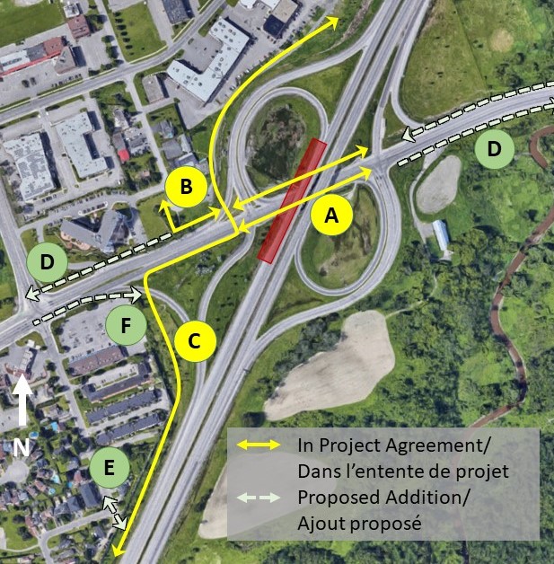


In Project Agreement:

A. Uni-directional cycle tracks and a 2.5m wide sidewalk on both sides of Montreal Road between the on and off ramps.

B. Multi-Use Pathway connecting the south end of Rainbow Street to Montreal Road.

C. Multi-Use Pathway along the north side of Highway 174 from Blair Road, continuing along the south side of Montreal Road with a cross ride/walk at signalised westbound off-ramp/ Montreal Road intersection, and continuing east to provide a connection to the Sir George Etienne Cartier Parkway.

Proposed Enhancements

D. Install an additional segment of cycle tracks along Montreal Road from Shefford Road to the on and off ramps.

E. Provide an opening to connect the East-West Multi-Use Pathway to the corner of Shefford Road and East Acres Road.

Additional Resources

Plan view: Montréal Road Cycle Tracks and Crossings


Jeanne d’Arc Station

Jeanne d’Arc Station will be constructed with entrances on both the east and west side of the Jeanne d’Arc Bridge. As the bridge structure has remaining lifespan, it is not being rebuilt, and therefore connectivity facilities are being designed within the existing width available.

Connectivity Summary


In Project Agreement:

A. Remove both free flow ramps on north side and direct traffic through the signalized intersection.

B. Multi-Use Pathway leading to the bicycle parking at Jeanne d’Arc Station from Fortune Drive (east side)

C. Bicycle parking shall be located immediately north and south of the Jeanne d’Arc Bridge (10 spaces each), on the east side.

D. Provide a 2m wide sidewalk on the east and west sides of Jeanne d’Arc Boulevard on the bridge.

Proposed Enhancements

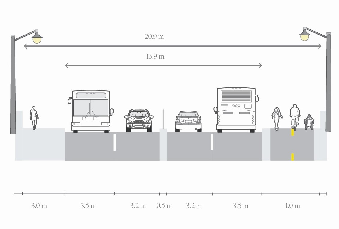
E. Modify road configuration over the bridge with narrow fenced centre median

F. Extend Multi-Use Pathway south, along east side of Jeanne d’Arc Boulevard, just past the eastbound on-ramp

Additional Resources

Plan view of Jeanne d’Arc Station
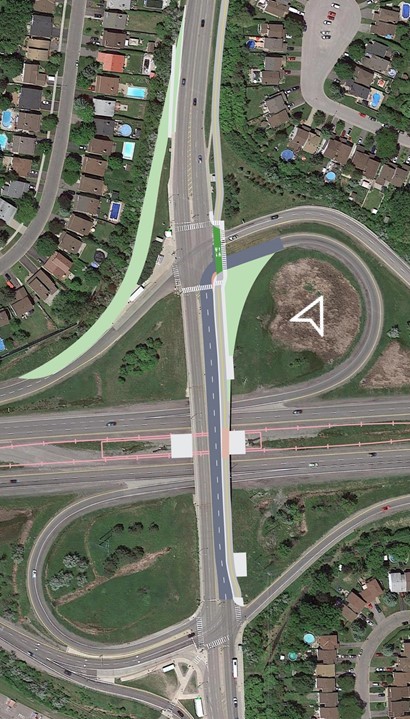


Proposed cross section of Jeanne d’Arc bridge


Orléans Boulevard Station

Orléans Boulevard Station will be constructed with entrances on both the east and west side of the Orléans Boulevard Bridge. As the bridge structure has remaining lifespan, it is not being rebuilt, and therefore connectivity facilities are being designed within the existing width available.

Connectivity Overview
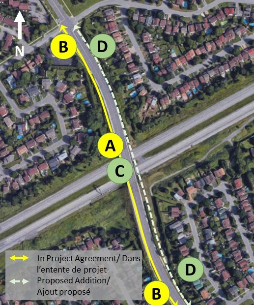


In Project Agreement:

A. Bicycle parking shall be located in equal quantities to the north and south of the station (10 each side), immediately adjacent to the Orléans Boulevard Bridge.

B. Widen the sidewalk from Lumberman Way and Fortune Drive to 2.5m, with the exception of the sidewalks on the bridge itself.

Proposed Enhancements

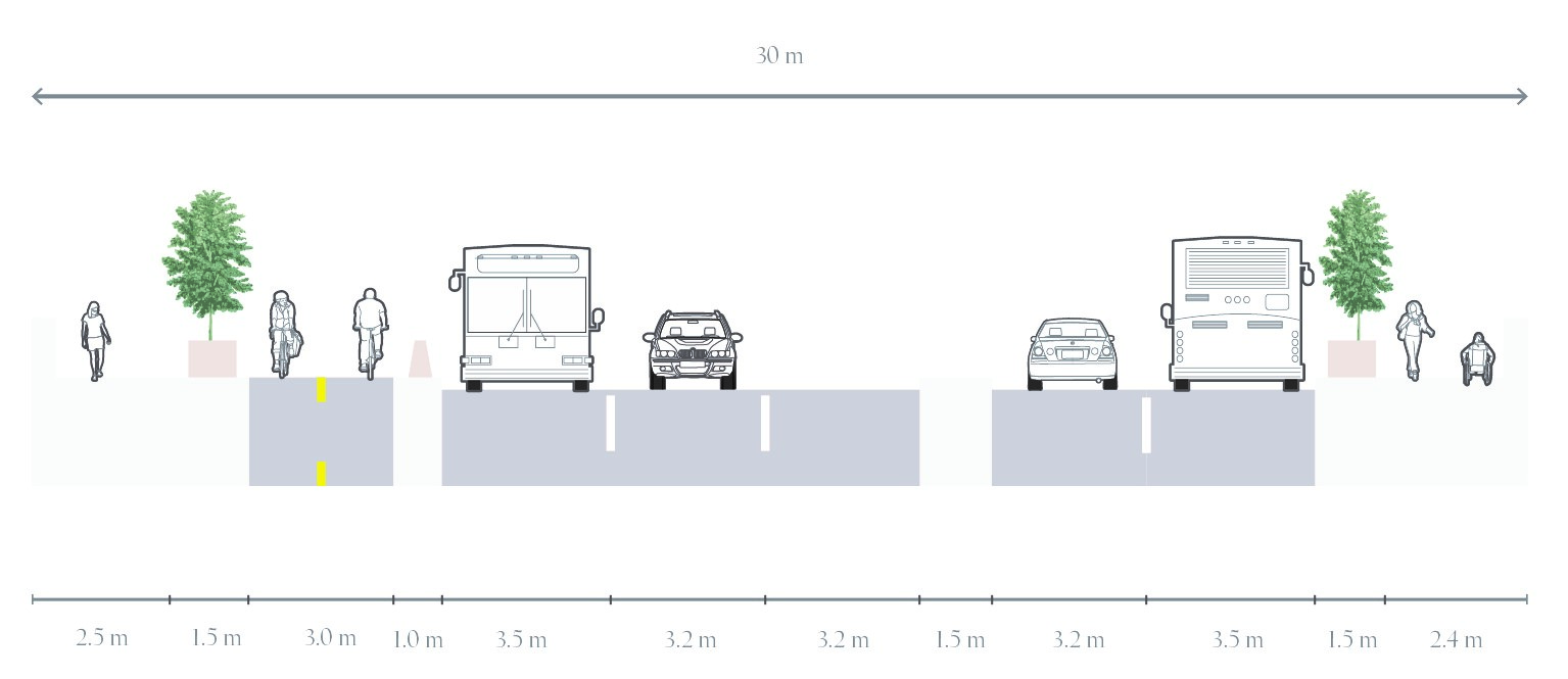
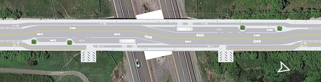
C. Reconfiguration of the Orléans Boulevard Bridge: Removal of 1 lane of traffic in each direction, Passenger Pick-up and Drop-off spaces, bus bays for buses stopped at the station, Multi-Use Pathway along east side, and uni-directional cycle track along west side.

D. Extend cycle tracks along Orléans Blvd. from Lumberman to Fortune

Additional Resources

Orléans Boulevard Bridge Reconfiguration


Place d'Orléans Station

Place d’Orléans Station will be constructed by utilizing existing transit infrastructure, with four entrances available from the following locations:
  • At the pedestrian bridge towards the train platform
  • At the pedestrian bridge towards the bus platform
  • At the Place d’Orléans Shopping Centre parking lot
  • From the Champlain Street Bridge

The Champlain Bridge structure is not being rebuilt as it has remaining lifespan. Improved connectivity facilities are being designed within existing width available.

Connectivity Overview
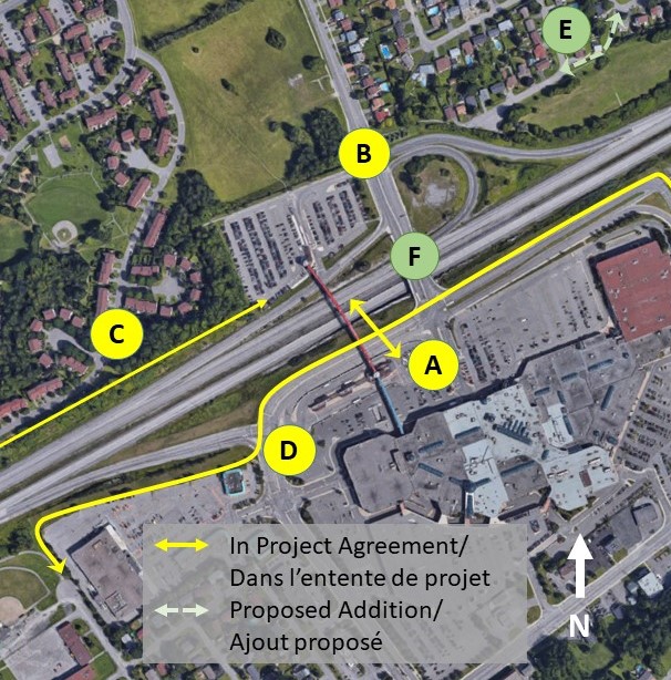


In Project Agreement:

A. New fare-paid pedestrian bridge from bus loop to station, permitting the existing pedestrian bridge to remain open for non-transit users.

B. Add a crossride at Champlain Street (north side) of Place d’Orléans and widen existing pathway between Alpine Street and Champlain

C. Formalize existing footpath between park and ride lot and Bilberry Drive to a standard Multi-Use Pathway

D. Provide a continuous Multi-Use Pathway along the south side of Highway 174, from the north end of St. Pierre Street, east to Champlain Street, connecting to Place d’Orléans Drive, and south to Centrum Boulevard

Proposed Enhancements

E. Upgrade Willow-Borland path to a multi-use path

F. Reconfigure Champlain Bridge to increase pedestrian and cycling safety and comfort

Additional Resources

Champlain Highway 174 Bridge Reconfiguration
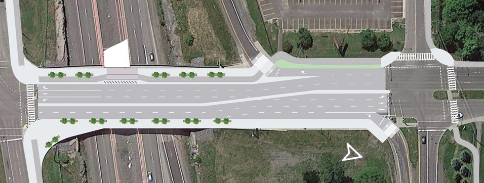


Proposed cross-section of Champlain Street bridge over OR-174, looking north.


Trim Station

Trim Station will be built within the centre median of Highway 174, requiring the realignment of Trim Road further east of the station, from Jeanne d’Arc Boulevard, to the roundabout south of the park and ride lot. The station will be built to permit the possibility of a future Highway Interchange in the original location of Trim Road, as a separate project. Station design will also protect for a future pedestrian bridge connecting to the north side of Highway 174, as a separate project.

Connectivity Overview
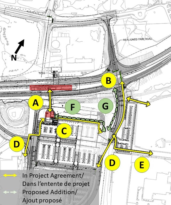


In Project Agreement:

A. A fare-paid pedestrian bridge from bus loop and park and ride lot on the south side of Highway 174, to Trim Station within the centre median.

B. Cross ride/walks on east and north legs of Trim Road/ OR 174 intersection

C. 3m wide sidewalk along north side of park and ride lot

D. A Multi-Use Pathway along the east side of the realigned Trim Road

E. Retention of Multi-Use Pathway connections to Cardinal Creek community

Proposed Enhancements

F. Upgrade sidewalk on north side of park and ride to a Multi-Use Pathway and extend to new realigned Trim Road

G. Add Multi-Use Pathway on west side of new realigned Trim Road

Let us know what you think!

If you have comments or questions related to Stage 2 Confederation Line East connectivity, please email [email protected] by Friday April 24, 2020.

All feedback will be captured in an “As We Heard It” report and published to Ottawa.ca/stage2.

Thank you for your participation!

Last edited by J.OT13; Apr 13, 2020 at 1:57 PM.
Reply With Quote
     
     
  #531  
Old Posted Apr 13, 2020, 2:23 PM
J.OT13's Avatar
J.OT13 J.OT13 is online now
Moderator
 
Join Date: Mar 2012
Location: Ottawa
Posts: 28,855
I'll take another crack at station names for the east segment. More controversial than before.

Montreal - Beacon Hill

Montreal Road is associated with Vanier, not the end of the street where it becomes St-Joseph. As the station only really serves Beacon Hill, it seems like a logical name.

Jeann d'Arc - Convent Glen

I previously had Orléans Boulevard as Convent Glen, but looking at the division of neighbourhoods, that section of Jeanne' d'Arc Boulevard seems more central.

The reason for eliminating the name Jeanne d'Arc, is that the Boulevard loops around the near entirety of Orléans, so the name cannot be associated to just one area.

Orléans Boulevard

The only station ever to be built at Orléans Boulevard, surrounded by neighbourhoods mostly named for Orléans.

Place d'Orléans - Queenswood

We don't want the name Orléans twice, so name it for neighbourhoods to the north and south.

Trim - Petrie's Landing

Trim is one of the longest streets in Ottawa, served by two stations (the other being Millenium), so the name is not representative of the area.

Furthermore, naming it Petrie's Landing could be part of the negotiations to build the pedestrian bridge to the north sooner rather than later.

I would even consider renaming Trim to Petrie between Petrie Island and Cardinal Creek park where it now turns (turn right from Trim to Trim).
Reply With Quote
     
     
  #532  
Old Posted Apr 13, 2020, 2:41 PM
Acajack's Avatar
Acajack Acajack is offline
Gros Méchant Loup
 
Join Date: Aug 2006
Location: Province 2, Canadian Empire
Posts: 72,949
Quote:
Originally Posted by J.OT13 View Post
I'll take another crack at station names for the east segment. More controversial than before.

Montreal - Beacon Hill

Montreal Road is associated with Vanier, not the end of the street where it becomes St-Joseph. As the station only really serves Beacon Hill, it seems like a logical name.
.
Not sure if you are suggesting calling it 'Montreal-Beacon Hill" or simply Beacon Hill.

I think the latter would be better.

They could also call this Green's Creek Station.

Also I think under the current naming convention this station would simply be called "Montreal" or "Montréal" which is even more confusing without the Road (or Chemin) added to it.

I agree it should be changed.
__________________
Loin des yeux, loin du coeur.
Reply With Quote
     
     
  #533  
Old Posted Apr 13, 2020, 2:44 PM
Acajack's Avatar
Acajack Acajack is offline
Gros Méchant Loup
 
Join Date: Aug 2006
Location: Province 2, Canadian Empire
Posts: 72,949
Quote:
Originally Posted by J.OT13 View Post
Jeann d'Arc - Convent Glen

I previously had Orléans Boulevard as Convent Glen, but looking at the division of neighbourhoods, that section of Jeanne' d'Arc Boulevard seems more central.

The reason for eliminating the name Jeanne d'Arc, is that the Boulevard loops around the near entirety of Orléans, so the name cannot be associated to just one area.

Orléans Boulevard

The only station ever to be built at Orléans Boulevard, surrounded by neighbourhoods mostly named for Orléans.

Place d'Orléans - Queenswood

We don't want the name Orléans twice, so name it for neighbourhoods to the north and south.
.
I don't see any scenario where the station at Place d'Orléans is named anything other than Place d'Orléans. That terminus and area has been known as that for almost 40 years. That counts for something.

As for the station at Orleans Blvd I dunno. Jeanne-d'Arc is also in Convent Glen I agree but I think it still works for this one,
__________________
Loin des yeux, loin du coeur.
Reply With Quote
     
     
  #534  
Old Posted Apr 13, 2020, 2:58 PM
J.OT13's Avatar
J.OT13 J.OT13 is online now
Moderator
 
Join Date: Mar 2012
Location: Ottawa
Posts: 28,855
Sorry for the confusion. To clarify, Old name - New name. So I'm proposing Beacon Hill as it's name. Green's Creek would also work, but it's probably less known than Beacon Hill (honestly did not know exactly where Green's Creek was until I Googled it just now).

God forbid they name it Montreal-Montréal, like Parliament-Parlement.

As for Place d'Orléans, I think you're right that there is no way it will ever have any other name. For me, it was more an exercise in figuring out the Jeanne d'Arc/Orléans Boulevard issue.
Reply With Quote
     
     
  #535  
Old Posted Apr 13, 2020, 3:21 PM
Acajack's Avatar
Acajack Acajack is offline
Gros Méchant Loup
 
Join Date: Aug 2006
Location: Province 2, Canadian Empire
Posts: 72,949
Quote:
Originally Posted by J.OT13 View Post

. For me, it was more an exercise in figuring out the Jeanne d'Arc/Orléans Boulevard issue.
Unless they name the Orleans Blvd station for some local notable person?
__________________
Loin des yeux, loin du coeur.
Reply With Quote
     
     
  #536  
Old Posted Apr 13, 2020, 3:30 PM
Acajack's Avatar
Acajack Acajack is offline
Gros Méchant Loup
 
Join Date: Aug 2006
Location: Province 2, Canadian Empire
Posts: 72,949
Quote:
Originally Posted by J.OT13 View Post
Sorry for the confusion. To clarify, Old name - New name. So I'm proposing Beacon Hill as it's name. Green's Creek would also work, but it's probably less known than Beacon Hill (honestly did not know exactly where Green's Creek was until I Googled it just now).

God forbid they name it Montreal-Montréal, like Parliament-Parlement.
.
Yeah,just thinking that Green's Creek might run into the classic Ottawa bilingual naming conundrum.

It's not like Beacon Hill which doesn't have a different name in French. I've never it referred to as Colline Beacon or Colline du Phare.

Green's Creek is NCC property and a geographic feature to boot, so my guess is that they'd pressure OC Transpo for a bilingual or language-neutral name (Ruisseau Green's Creek or simply Green).

Though we did avoid Pré Tunney's Pasture for Tunney's Pasture Station, somehow. It's Station Tunney's Pasture in French too. (I believe that "name" doesn't belong to the NCC, though.)

The City of Ottawa also seems less averse than it used to be to naming things only in English. For example when it took over the Airport Parkway from the NCC the official name of the road went from Airport Parkway-Promenade de l'Aéroport to Promenade Airport Parkway. Or only in French in some cases. Vanier used to have a White Fathers Road - Avenue des Pères-Blanc. I believe it's only Pères-Blancs now. Also in Vanier, Church St. near the Lourdes grotto was changed to Rue de l'Église Street. I believe this was because there was another Church St. elsewhere in the newly merged mega-Ottawa.

There aren't many bilingual names in Ottawa anymore - at least not that are used by the city. The only notable one I can think of is Sandy Hill - Côte-de-Sable.

Historic but informal French names for streets like St. Patrick (Saint-Patrice), St. Andrew (Saint-André) or Tenth Line (Dixième Ligne) have also fallen into disuse among local francophones.
__________________
Loin des yeux, loin du coeur.
Reply With Quote
     
     
  #537  
Old Posted Apr 13, 2020, 6:14 PM
CityTech CityTech is offline
Registered User
 
Join Date: May 2016
Location: Ottawa
Posts: 2,798
Quote:
Originally Posted by Acajack View Post
I don't see any scenario where the station at Place d'Orléans is named anything other than Place d'Orléans. That terminus and area has been known as that for almost 40 years. That counts for something.

As for the station at Orleans Blvd I dunno. Jeanne-d'Arc is also in Convent Glen I agree but I think it still works for this one,
How about Bilberry, after the nearby Bilberry Creek, for Orleans Boulevard?

I'd keep Jeanne d'Arc as is. It's an existing name and the major bus feeder routes connecting to it (38 and 30--they might be merged after Phase 2 is open) both follow Jeanne d'Arc.

Montreal could maybe be Canotek, after the nearby business park. Canotek business park commuters will probably be the main users of the station anyway.
Reply With Quote
     
     
  #538  
Old Posted Apr 13, 2020, 6:26 PM
CityTech CityTech is offline
Registered User
 
Join Date: May 2016
Location: Ottawa
Posts: 2,798
Quote:
Originally Posted by Acajack View Post
Yeah,just thinking that Green's Creek might run into the classic Ottawa bilingual naming conundrum.

It's not like Beacon Hill which doesn't have a different name in French. I've never it referred to as Colline Beacon or Colline du Phare.

Green's Creek is NCC property and a geographic feature to boot, so my guess is that they'd pressure OC Transpo for a bilingual or language-neutral name (Ruisseau Green's Creek or simply Green).

Though we did avoid Pré Tunney's Pasture for Tunney's Pasture Station, somehow. It's Station Tunney's Pasture in French too. (I believe that "name" doesn't belong to the NCC, though.)

The City of Ottawa also seems less averse than it used to be to naming things only in English. For example when it took over the Airport Parkway from the NCC the official name of the road went from Airport Parkway-Promenade de l'Aéroport to Promenade Airport Parkway. Or only in French in some cases. Vanier used to have a White Fathers Road - Avenue des Pères-Blanc. I believe it's only Pères-Blancs now. Also in Vanier, Church St. near the Lourdes grotto was changed to Rue de l'Église Street. I believe this was because there was another Church St. elsewhere in the newly merged mega-Ottawa.

There aren't many bilingual names in Ottawa anymore - at least not that are used by the city. The only notable one I can think of is Sandy Hill - Côte-de-Sable.

Historic but informal French names for streets like St. Patrick (Saint-Patrice), St. Andrew (Saint-André) or Tenth Line (Dixième Ligne) have also fallen into disuse among local francophones.
They did actually want to shorten the Tunney's Pasture station name to just "Tunney", in order to make it bilingual, but that proposal was dropped.

All street names in Ottawa are officially in one language. There's no way in Ontario law for a street to have different names in English and French.

A lot of the former leeway that used to be given to translate street names as you referred to with historic names like White Fathers Road - Avenue des Pères-Blanc, disappeared with the rollout of 911 emergency dialling, as that required consistent provincewide guidelines to be adopted for street names, and that included them being uniform in all languages.

Even the street type part (ie. Street/Rue, Road/Chemin, Boulevard/Promenade, etc.) is only unofficially translated, as for legal purposes, only the English street type word is technically valid; this is generally only relevant for things like property deeds.

One goofy example of how this can play out: in some Franco-Ontarian communities (like Casselman), property deeds for the main road of the town will say the home is on "Principale Street". Another odd historic example is that some townships in some francophone areas in Ontario used to have roads with type "Montée". Because Montée is not a legal street type in Ontario, technically such roads had Montée be part of the name itself and the street suffix would be null/blank. But with 911 dialing, many of those roads had the Montée dropped and simply became Roads.
Reply With Quote
     
     
  #539  
Old Posted Apr 13, 2020, 6:54 PM
J.OT13's Avatar
J.OT13 J.OT13 is online now
Moderator
 
Join Date: Mar 2012
Location: Ottawa
Posts: 28,855
Quote:
Originally Posted by CityTech View Post
How about Bilberry, after the nearby Bilberry Creek, for Orleans Boulevard?
Bilberry Creek Station. That works! Anything to eliminate the two Orléans. And it would emphasize a pretty cool natural feature in the middle of Orleans.

I've heard "Tenth Line - Dixième Ligne" a handful of times riding the bus over the years. Very inconsistent, but it has happened. I think that was a few years ago (2017-2019). I don't remember hearing that since Line 1 opened.

One thing that absolutely should changed in the guidelines is the allowing roads that are cut-off to maintain their current name. Trim Road, Fallowfield, Moodie and many more are cut-off or one has to make a turn at an intersection to continue on the same street (name). One would think that would be an issue.

Richmond, Old Richmond, Tenth Line, Old Tenth Line partially resolves this, but it's often historically inaccurate.
Reply With Quote
     
     
  #540  
Old Posted Apr 13, 2020, 7:51 PM
Acajack's Avatar
Acajack Acajack is offline
Gros Méchant Loup
 
Join Date: Aug 2006
Location: Province 2, Canadian Empire
Posts: 72,949
Quote:
Originally Posted by J.OT13 View Post
Bilberry Creek Station. That works! Anything to eliminate the two Orléans. And it would emphasize a pretty cool natural feature in the middle of Orleans.

I've heard "Tenth Line - Dixième Ligne" a handful of times riding the bus over the years. Very inconsistent, but it has happened. I think that was a few years ago (2017-2019). I don't remember hearing that since Line 1 opened.

One thing that absolutely should changed in the guidelines is the allowing roads that are cut-off to maintain their current name. Trim Road, Fallowfield, Moodie and many more are cut-off or one has to make a turn at an intersection to continue on the same street (name). One would think that would be an issue.

Richmond, Old Richmond, Tenth Line, Old Tenth Line partially resolves this, but it's often historically inaccurate.
And of course Wellington and West Wellington (or is it Wellington West?).
__________________
Loin des yeux, loin du coeur.
Reply With Quote
     
     
This discussion thread continues

Use the page links to the lower-right to go to the next page for additional posts
 
 
Reply

Go Back   SkyscraperPage Forum > Regional Sections > Canada > Ontario > Ottawa-Gatineau > Transportation
Forum Jump


Forum Jump


All times are GMT. The time now is 8:03 PM.


Powered by vBulletin® Version 3.8.7
Copyright ©2000 - 2026, vBulletin Solutions, Inc.