HomeDiagramsDatabaseMapsForum About
     

Go Back   SkyscraperPage Forum > Regional Sections > Canada > Alberta & British Columbia > Vancouver > Urban, Urban Design & Heritage Issues


Reply

 
Thread Tools Display Modes
     
     
  #281  
Old Posted May 30, 2019, 10:06 PM
Vin Vin is offline
Registered User
 
Join Date: Sep 2013
Posts: 8,738
Quote:
Originally Posted by Krissy View Post
Oh do explain...

(1)Vancouver's downtown is denser and more populated than Burnaby's town centres combined.

(2)Vancouver's single family neighbourhood is more compact than Burnaby's.

(3)Vancouver street grid is compact and walkable compared to Burnaby's .

(4)You post a link to a map but evidently you don't bother to look at it.
(1) Vancouver's downtown grid and compact plan was designed from the 1800s. I laud the planners of the past, and will always do so. The city has had more than a century of headstart to get to what it is today. The current generation is riding on the glory of the past, but slowly ruining it as the suburb cities today have better long-term visions.

(2) Numbers please? Which areas are you comparing? West side? East side? I've said before that Burnaby started out as a SFH suburb, but the City has been taking great steps in improving their density, and the results are showing today. Besides, Burnaby's SFH neighbourhoods do not occupy the entire city, leaving lots of parklands, woodlands and even agricultural lands, unlike Vancouver's. If Burnaby did not embark on the town centre developments, SFH would have engulfed all the available green and industrial spaces by now.

(3) Again see point (1). Other than downtown, where else is Vancouver really "walkable"? The city is blessed with a lot of coastal land which makes it rather walkable, but that's no excuse for the inability to improve the inland areas. At least Burnaby town centres are increasingly walkable as compared to 10 years ago, and will get more compact in the coming years.

(4) I think you are the one not looking at it. Either that or you fail to interpret it properly. I've already explained about it numerous times, but you and Squeezied could only utter "you are not looking at the map".
Reply With Quote
     
     
  #282  
Old Posted May 30, 2019, 10:07 PM
GenWhy? GenWhy? is online now
Registered User
 
Join Date: Jun 2017
Posts: 4,831
Quote:
Originally Posted by Vin View Post
Original Denny's site rental flat design:
https://dailyhive.com/vancouver/2538-birch-street-vancouver-1296-west-broadway-2018

The original tower at the W. Broadway Denny's site had a nicer design, IMO. Really dislike the "broken up" look to the new facade as per CoV's preference. However, the new rendering also seems to be showing a taller tower at 28 storeys. Perhaps the developer received hints of the general height allowance after the West Broadway plan was initiated? Still hoping for some 40-storey site allowance for many of the sites here.
Re-read the above posts, Vin.

The "broken up" façade is an architects doing, not the CofV.
Reply With Quote
     
     
  #283  
Old Posted May 31, 2019, 3:49 AM
misher's Avatar
misher misher is offline
BANNED
 
Join Date: Jul 2018
Posts: 4,537
Quote:
Originally Posted by GenWhy? View Post
Re-read the above posts, Vin.

The "broken up" façade is an architects doing, not the CofV.
Went to two of the Broadway walking tours. A lot more 1
On 1 then the open houses. Funnily the NIMBY lobby of old renters/homeowners showed up but there now pushing 12 stories or less (they gave up!). About a third of participants identified themselves as developers and half the room was pushing 40+ stories. Looks like we’re going to end up with around 20 by stations with even the NIMBY lobby not debating that.
Reply With Quote
     
     
  #284  
Old Posted May 31, 2019, 4:14 AM
Migrant_Coconut's Avatar
Migrant_Coconut Migrant_Coconut is offline
Registered User
 
Join Date: Oct 2015
Location: Kitsilano/Fairview
Posts: 10,154
Well hot damn, even our NIMBYs are progressive!
Reply With Quote
     
     
  #285  
Old Posted May 31, 2019, 4:30 AM
scryer scryer is offline
Registered User
 
Join Date: Feb 2014
Posts: 1,964
Quote:
Originally Posted by Migrant_Coconut View Post
Well hot damn, even our NIMBYs are progressive!
I sincerely doubt it .
Reply With Quote
     
     
  #286  
Old Posted Jun 3, 2019, 4:45 AM
squeezied's Avatar
squeezied squeezied is offline
Registered User
 
Join Date: Jul 2006
Location: Vancouver, BC
Posts: 1,625
Quote:
Originally Posted by Vin View Post
(1) Vancouver's downtown grid and compact plan was designed from the 1800s. I laud the planners of the past, and will always do so. The city has had more than a century of headstart to get to what it is today. The current generation is riding on the glory of the past, but slowly ruining it as the suburb cities today have better long-term visions.

(2) Numbers please? Which areas are you comparing? West side? East side? I've said before that Burnaby started out as a SFH suburb, but the City has been taking great steps in improving their density, and the results are showing today. Besides, Burnaby's SFH neighbourhoods do not occupy the entire city, leaving lots of parklands, woodlands and even agricultural lands, unlike Vancouver's. If Burnaby did not embark on the town centre developments, SFH would have engulfed all the available green and industrial spaces by now.

(3) Again see point (1). Other than downtown, where else is Vancouver really "walkable"? The city is blessed with a lot of coastal land which makes it rather walkable, but that's no excuse for the inability to improve the inland areas. At least Burnaby town centres are increasingly walkable as compared to 10 years ago, and will get more compact in the coming years.

(4) I think you are the one not looking at it. Either that or you fail to interpret it properly. I've already explained about it numerous times, but you and Squeezied could only utter "you are not looking at the map".
Well, since you brought up my name... Give it up Vin, you sound like a 12 year old. Your Vin logic is just getting worse and worse.

(1) So you think Vancouver is ruining itself by densifying its SF neighbourhoods by building a variety of compact housing types: townhomes, midrises and highrises? Are you so narrow minded that you think only highrises are the way to go? Again, you're fooling yourself if you think neighbourhoods with modest heights cannot be dense. Collingwood, Marpole, Kitsilano and especially the West End have modest heights but high densities. So what's my point? Stop pretending you actually care about density and just say you just like tall buildings, nothing more.

(2) Obviously obvious facts aren't obvious to you... Here's another density map with the numbers you so desire (yet you yourself aren't able provide any real facts other Vin facts).
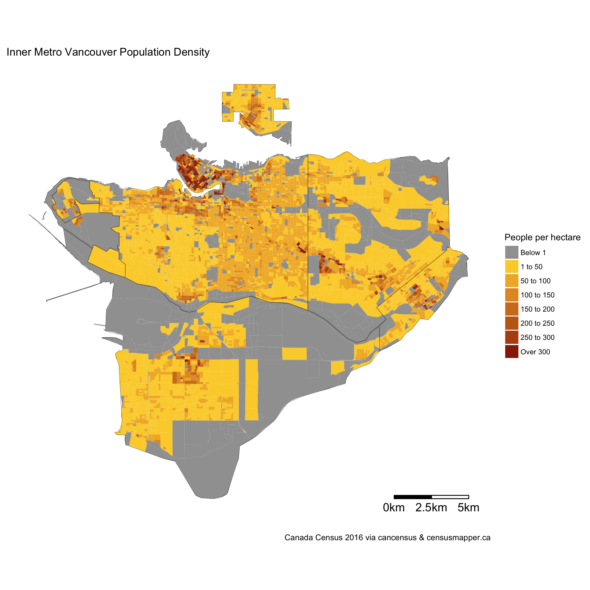
source: https://doodles.mountainmath.ca/blog/2017/09/08/the-vienna-model/

Burnaby's town centres are surrounded by low density SFH, with similar densities to Vancouver's SF West Side neighbourhoods. There's no comparison the much denser East side.

To save youself embarrassment, those grey areas are undeveloped/underdeveloped not because of Burnaby decided to build town centres to curb SFH development (which is seriously one of the most ridiculous things coming from you), they're grey because of geographical and land zoning reasons. Starting from the north, there's Burnaby mountain, Burnaby Lake, HWY 1 right-of-way, Deer Lake and the low-density industrial and office parks of south Burnaby. So applying Vin logic, you think if Burnaby didn't build high rises in its town centres they would instead build SFH on steep mountains or swampy grounds next to a lake? Put some logic into your thinking please. If Burnaby didn't build highrises in its town centres people would just live elsewhere. Would it cause sprawl in some outlying areas of the region? Probably. Would it cause a SFH to sprout out in the marshlands of Burnaby Lake? Get real.

(3) You really have no idea what walkability is. What does 'coastal' lands have anything to do with walkability? Inland areas can't be walkable? You make it sound as though only highrises allow neighbourhoods to be walkable, which is ludicrous. Again, Collingwood, Marpole, Kitsilano and the West End... all walkable. Even most of the SF neighbourhoods in Vancouver are very walkable with the grid layout with retail and shops lining a good portion of the arterial roads, particularily in the northern half of the city. Burnaby, as well as most other suburbs, has large-scale blocks with windy curvy streets and its arterials are just lined with more SFH. There's a good reason why people drive more in the suburbs than in Vancouver, because that's how it was designed. And frankly, while it's great that Burnaby is building high rises in its town centres, don't fool yourself into thinking these are in the same walkability level as you'd find in Vancouver. These towers are still very suburban in design with surface parking, driveways and empty lawn. Google Vantage in Brentwood if you have no idea what I'm talking about. I don't see much pedestrians there, for a good reason. Before you respond, look up what walkability is, because evidently you have no idea what it means.

(4) I think I've said enough. Clearly you're the one who doesn't look at maps or read up on facts. Instead you rely on your own misguided Vin logic and misinterpret things to suit your narrow ideals, namely 'taller is better, no argument!'. I would suggest that you get outside of your Yaletown bubble and really see the rest of the region for what it really is instead of coming up with this flawed logic of yours. Because seriously, your arrogance is only surpassed by your ignorance.

Reply With Quote
     
     
  #287  
Old Posted Jun 3, 2019, 5:23 AM
Changing City's Avatar
Changing City Changing City is online now
Registered User
 
Join Date: Nov 2016
Posts: 8,258
Quote:
Originally Posted by squeezied View Post
Collingwood, Marpole, Kitsilano and especially the West End have modest heights but high densities.
That fine grained density map really helps put the Broadway corridor is perspective - it's already got significant residential density (and of course, where there's low residential density in areas like West Broadway and Cambie, and in the Mount Pleasant industrial area, it's because there's high employment density instead).

It's interesting to note that Southeast False Creek - which was only maybe 50% built out in 2016 - still has density as high as Downtown and the West End. It's also good to see the density at Joyce station - that piece of T.O.D. often gets overlooked. The 2021 census data should see much more impact from the development up and down Cambie Street, and at Marine Drive, as well as filling in Main Street north from West Broadway.
__________________
Contemporary Vancouver development blog, https://changingcitybook.wordpress.com/ Then and now Vancouver blog https://changingvancouver.wordpress.com/
Reply With Quote
     
     
  #288  
Old Posted Jun 3, 2019, 3:49 PM
WarrenC12's Avatar
WarrenC12 WarrenC12 is online now
Registered User
 
Join Date: May 2007
Location: East OV!
Posts: 24,631
Interesting map. Kits is fairly dense as well, despite not having any tall towers and resisting a lot of redevelopment.

What's lacking is density nodes around Skytrain stations, particularly through East Van, as we all know, but also the Canada Line. I suspect we'll see a big change in the next census for that.
Reply With Quote
     
     
  #289  
Old Posted Jun 3, 2019, 7:44 PM
Krissy Krissy is offline
Registered User
 
Join Date: Jan 2016
Location: Burnaby
Posts: 63
Quote:
Originally Posted by Changing City View Post
It's interesting to note that Southeast False Creek - which was only maybe 50% built out in 2016 - still has density as high as Downtown and the West End. It's also good to see the density at Joyce station - that piece of T.O.D. often gets overlooked. The 2021 census data should see much more impact from the development up and down Cambie Street, and at Marine Drive, as well as filling in Main Street north from West Broadway.
Shhh... don't mention Southeast False Creek being dense... Vin refuses to believe it's dense with only mid-rises.
Reply With Quote
     
     
  #290  
Old Posted Jun 3, 2019, 8:03 PM
whatnext whatnext is offline
Registered User
 
Join Date: Feb 2009
Location: Vancouver
Posts: 27,855
Quote:
Originally Posted by Krissy View Post
Shhh... don't mention Southeast False Creek being dense... Vin refuses to believe it's dense with only mid-rises.
But it's gotta have a mall!!!
Reply With Quote
     
     
  #291  
Old Posted Jun 3, 2019, 8:30 PM
Vin Vin is offline
Registered User
 
Join Date: Sep 2013
Posts: 8,738
Quote:
Originally Posted by squeezied View Post
Well, since you brought up my name... Give it up Vin, you sound like a 12 year old. Your Vin logic is just getting worse and worse.

(1) So you think Vancouver is ruining itself by densifying its SF neighbourhoods by building a variety of compact housing types: townhomes, midrises and highrises? Are you so narrow minded that you think only highrises are the way to go? Again, you're fooling yourself if you think neighbourhoods with modest heights cannot be dense. Collingwood, Marpole, Kitsilano and especially the West End have modest heights but high densities. So what's my point? Stop pretending you actually care about density and just say you just like tall buildings, nothing more.

(2) Obviously obvious facts aren't obvious to you... Here's another density map with the numbers you so desire (yet you yourself aren't able provide any real facts other Vin facts).

source: https://doodles.mountainmath.ca/blog/2017/09/08/the-vienna-model/

Burnaby's town centres are surrounded by low density SFH, with similar densities to Vancouver's SF West Side neighbourhoods. There's no comparison the much denser East side.

To save youself embarrassment, those grey areas are undeveloped/underdeveloped not because of Burnaby decided to build town centres to curb SFH development (which is seriously one of the most ridiculous things coming from you), they're grey because of geographical and land zoning reasons. Starting from the north, there's Burnaby mountain, Burnaby Lake, HWY 1 right-of-way, Deer Lake and the low-density industrial and office parks of south Burnaby. So applying Vin logic, you think if Burnaby didn't build high rises in its town centres they would instead build SFH on steep mountains or swampy grounds next to a lake? Put some logic into your thinking please. If Burnaby didn't build highrises in its town centres people would just live elsewhere. Would it cause sprawl in some outlying areas of the region? Probably. Would it cause a SFH to sprout out in the marshlands of Burnaby Lake? Get real.

(3) You really have no idea what walkability is. What does 'coastal' lands have anything to do with walkability? Inland areas can't be walkable? You make it sound as though only highrises allow neighbourhoods to be walkable, which is ludicrous. Again, Collingwood, Marpole, Kitsilano and the West End... all walkable. Even most of the SF neighbourhoods in Vancouver are very walkable with the grid layout with retail and shops lining a good portion of the arterial roads, particularily in the northern half of the city. Burnaby, as well as most other suburbs, has large-scale blocks with windy curvy streets and its arterials are just lined with more SFH. There's a good reason why people drive more in the suburbs than in Vancouver, because that's how it was designed. And frankly, while it's great that Burnaby is building high rises in its town centres, don't fool yourself into thinking these are in the same walkability level as you'd find in Vancouver. These towers are still very suburban in design with surface parking, driveways and empty lawn. Google Vantage in Brentwood if you have no idea what I'm talking about. I don't see much pedestrians there, for a good reason. Before you respond, look up what walkability is, because evidently you have no idea what it means.

(4) I think I've said enough. Clearly you're the one who doesn't look at maps or read up on facts. Instead you rely on your own misguided Vin logic and misinterpret things to suit your narrow ideals, namely 'taller is better, no argument!'. I would suggest that you get outside of your Yaletown bubble and really see the rest of the region for what it really is instead of coming up with this flawed logic of yours. Because seriously, your arrogance is only surpassed by your ignorance.

Say what you want, and do continue with your insults, as those seem to be the only things you are good at anyways. I always maintain what I say, and that the direction suburb municipalities are heading is way better than Vancouver's in creating density. They can manage to increase their population by having compact city centres, and the only way at the moment to achieve that fast is to go tall. See the article below to see the rate of population increase in the Lower Mainland. If your argument is true, how come Vancouver does not attract the people to move in?

https://www.abbynews.com/news/surrey-port-moody-fastest-metro-vancouver-growers-in-new-census/

You just want to keep arguing that many parts of Vancouver are denser when compared to the suburbs, true, but if if the same map you just showed us exist for one showing what the 80s or 90s were like: it would probably show Burnaby and other municipalities to be almost entirely yellow, and Vancouver similar to what it is today. It's the rate of increase we are talking about today, and outside downtown, Vancouver is definitely is definitely falling behind compared to the burbs.
Reply With Quote
     
     
  #292  
Old Posted Jun 3, 2019, 8:34 PM
misher's Avatar
misher misher is offline
BANNED
 
Join Date: Jul 2018
Posts: 4,537
Quote:
Originally Posted by Vin View Post
Say what you want, and do continue with your insults, as those seem to be the only things you are good at anyways. I always maintain what I say, and that the direction suburb municipalities are heading is way better than Vancouver's in creating density. They can manage to increase their population by having compact city centres, and the only way at the moment to achieve that fast is to go tall. See the article below to see the rate of population increase in the Lower Mainland. If your argument is true, how come Vancouver does not attract the people to move in?

https://www.abbynews.com/news/surrey-port-moody-fastest-metro-vancouver-growers-in-new-census/

You just want to keep arguing that many parts of Vancouver are denser when compared to the suburbs, true, but if if the same map you just showed us exist for one showing what the 80s or 90s were like: it would probably show Burnaby and other municipalities to be almost entirely yellow, and Vancouver similar to what it is today. It's the rate of increase we are talking about today, and outside downtown, Vancouver is definitely is definitely falling behind compared to the burbs.
This is my feeling too although I don't have exact numbers to prove it.
Burnaby, Surrey, and Richmond have had crazily fast development.
Reply With Quote
     
     
  #293  
Old Posted Jun 3, 2019, 8:37 PM
Vin Vin is offline
Registered User
 
Join Date: Sep 2013
Posts: 8,738
Another one showing population density changes in recent times....

https://www.movinginalivableregion.ca/wp-content/uploads/2014/01/populationandemploymentdensity.jpg

Note that the most population increases occurred in centres with tall buildings. East Van's population density hadn't changed much. This diagram from 2011 was even before all the recent skyscrapers were completed in the suburb town centres.

Quote:
Originally Posted by misher View Post
This is my feeling too although I don't have exact numbers to prove it.
Burnaby, Surrey, and Richmond have had crazily fast development.
Those with eyes can definitely see that. Richmond for instance is creating a lot of high-density housing in a relatively small area, although the City was traditionally mostly industrial as well as agricultural.
Reply With Quote
     
     
  #294  
Old Posted Jun 3, 2019, 8:40 PM
Changing City's Avatar
Changing City Changing City is online now
Registered User
 
Join Date: Nov 2016
Posts: 8,258
Quote:
Originally Posted by Vin View Post
Another one showing population density changes in recent times....

https://www.movinginalivableregion.ca/wp-content/uploads/2014/01/populationandemploymentdensity.jpg

Note that the most population increases occurred in centres with tall buildings. East Van's population density hadn't changed much.
No it isn't - it's a guess by SFU at the future (to 2041). It may or may not be a very good guess.
__________________
Contemporary Vancouver development blog, https://changingcitybook.wordpress.com/ Then and now Vancouver blog https://changingvancouver.wordpress.com/
Reply With Quote
     
     
  #295  
Old Posted Jun 3, 2019, 8:44 PM
Vin Vin is offline
Registered User
 
Join Date: Sep 2013
Posts: 8,738
Quote:
Originally Posted by Changing City View Post
No it isn't - it's a guess by SFU at the future (to 2041). It may or may not be a very good guess.
Universities don't just publish fake stuff. They see the trends that I was talking about to make this prediciton. Obviously back in 2011 the trend already started.
Reply With Quote
     
     
  #296  
Old Posted Jun 3, 2019, 8:50 PM
Changing City's Avatar
Changing City Changing City is online now
Registered User
 
Join Date: Nov 2016
Posts: 8,258
Quote:
Originally Posted by misher View Post
This is my feeling too although I don't have exact numbers to prove it.
Burnaby, Surrey, and Richmond have had crazily fast development.
I do. Rate of growth isn't really meaningful - amount of growth is. If somewhere has a large population already, adding 5% to the population could be more people than 25% of a small municipality.

As Vin said 80s, 90s, here's 30 years change for the larger Metro Vancouver municipalities (1986-2016). No surprises, Surrey has the most. But then...

Surrey +336,440
Vancouver +199,101
Richmond +89,817
Burnaby +87,594
Coquitlam +70,018
Langley City +63,851
Maple Ridge +46,233
New Westminster +31,024
Port Coquitlam +29,497
Delta +22,628.

All other municipalities added under 20,000 in 30 years.
__________________
Contemporary Vancouver development blog, https://changingcitybook.wordpress.com/ Then and now Vancouver blog https://changingvancouver.wordpress.com/
Reply With Quote
     
     
  #297  
Old Posted Jun 3, 2019, 8:50 PM
Changing City's Avatar
Changing City Changing City is online now
Registered User
 
Join Date: Nov 2016
Posts: 8,258
Quote:
Originally Posted by Vin View Post
Universities don't just publish fake stuff. They see the trends that I was talking about to make this prediciton. Obviously back in 2011 the trend already started.
Who said it was fake?
__________________
Contemporary Vancouver development blog, https://changingcitybook.wordpress.com/ Then and now Vancouver blog https://changingvancouver.wordpress.com/
Reply With Quote
     
     
  #298  
Old Posted Jun 3, 2019, 8:52 PM
Galaxy's Avatar
Galaxy Galaxy is offline
Registered User
 
Join Date: Mar 2017
Location: Vancouver
Posts: 475
Vin is right about the overall amount of change happening out towards areas like Surrey/Langley/New West/Abbotsford. I grew up in those areas and remember a whole lot more trees and farmland and much smaller roads with a whole lot less traffic. The rate of change out there has been mind-boggling. Way more traffic/ Way more building/ way more retailers/ even within the City proper of Langley has been demoing large numbers of single-family homes and redeveloping them into midrise dense condos and apartments. The growth is reflected in why the schools are busting at the seams literally.

The housing market and sales out there are still very strong and people are still putting offers down and others are still loosing out on housing because someone else is offering a better price.

False Creek south is growing also and reflective of that growth though is the continuing protest of people in that area for the Vancouver School Board to build them a school because their kids want to go to the school that was part of the development plan.
Reply With Quote
     
     
  #299  
Old Posted Jun 3, 2019, 8:53 PM
Vin Vin is offline
Registered User
 
Join Date: Sep 2013
Posts: 8,738
Quote:
Originally Posted by Changing City View Post
Who said it was fake?
It's not a good guess. The map was made from population growth trends.

Quote:
Originally Posted by Changing City View Post
I do. Rate of growth isn't really meaningful - amount of growth is. If somewhere has a large population already, adding 5% to the population could be more people than 25% of a small municipality.

As Vin said 80s, 90s, here's 30 years change for the larger Metro Vancouver municipalities (1986-2016). No surprises, Surrey has the most. But then...

Surrey +336,440
Vancouver +199,101
Richmond +89,817
Burnaby +87,594
Coquitlam +70,018
Langley City +63,851
Maple Ridge +46,233
New Westminster +31,024
Port Coquitlam +29,497
Delta +22,628.

All other municipalities added under 20,000 in 30 years.
For a city the size of Vancouver, we should be able to house at least a million people by now. Yet over 30 years the population never increased too much. I bet a big proportion of the 199,101 population in the growth went into the downtown highrises. Would be nice to see a distribution map of that.
Reply With Quote
     
     
  #300  
Old Posted Jun 3, 2019, 9:01 PM
Changing City's Avatar
Changing City Changing City is online now
Registered User
 
Join Date: Nov 2016
Posts: 8,258
Quote:
Originally Posted by Vin View Post
It's not a good guess. The map was made from population growth trends.
Right - it's not a good guess because it doesn't take into account where growth might occur in Vancouver (for example). It significantly underestimates Cambie Corridor, it has no growth along East Hastings, but now there's a plan, and a whole series of higher density residential proposals that will see more growth than they indicate. I have no idea how good it is in suburban predictions, but it's not that good in Vancouver.

And to drag this back (again) to Broadway - it doesn't assume a plan for more density along Broadway because five years ago, when they made their guess, there wasn't a plan. In a couple of years there will be a plan, and by 2041 there's almost certain to be a lot more density than their guess shows.
__________________
Contemporary Vancouver development blog, https://changingcitybook.wordpress.com/ Then and now Vancouver blog https://changingvancouver.wordpress.com/
Reply With Quote
     
     
This discussion thread continues

Use the page links to the lower-right to go to the next page for additional posts
 
 
Reply

Go Back   SkyscraperPage Forum > Regional Sections > Canada > Alberta & British Columbia > Vancouver > Urban, Urban Design & Heritage Issues
Forum Jump


Forum Jump


All times are GMT. The time now is 11:51 PM.


Powered by vBulletin® Version 3.8.7
Copyright ©2000 - 2026, vBulletin Solutions, Inc.