HomeDiagramsDatabaseMapsForum About
     

Go Back   SkyscraperPage Forum > Regional Sections > Canada


Closed Thread

 
Thread Tools Display Modes
     
     
  #7241  
Old Posted Dec 31, 2018, 7:17 PM
sonysnob sonysnob is offline
Registered User
 
Join Date: Aug 2011
Posts: 1,797
^ Where? I don't recall any such signs, aside from the blue ones at the city limits.
     
     
  #7242  
Old Posted Dec 31, 2018, 7:21 PM
Dengler Avenue's Avatar
Dengler Avenue Dengler Avenue is offline
Road Engineer Wannabe
 
Join Date: Sep 2017
Location: Côté Ouest de la Rivière des Outaouais
Posts: 8,669
Quote:
Originally Posted by sonysnob View Post
^ Where? I don't recall any such signs, aside from the blue ones at the city limits.
Yea that
__________________
My Proposal of TCH Twinning in Northern Ontario
Disclaimer: Most of it is pure pie in the sky, so there's no need to be up in the arm about it.
     
     
  #7243  
Old Posted Dec 31, 2018, 8:48 PM
wave46 wave46 is offline
Closed account
 
Join Date: Aug 2016
Posts: 3,875
Quote:
Originally Posted by Acajack View Post
Funnily enough, Ottawa still has "Ottawa" as a control city in tons of places within the city limits. Often well within the city limits.

For example, this is just before St-Laurent Blvd. so well within the urbanized part of Ottawa (and well inside the Greenbelt too), but it still says "Ottawa" as the destination for the 417.

Fairly new (post-merger) signage in parts of Ottawa like Kanata, Orleans and Barrhaven also points to "Ottawa" as a control city.
I don't understand why the suburbs of Ottawa got special treatment either, especially post-merger.

You still see newer signs with "Nepean" and "Kanata" on them, while within Toronto, I've never seen "Scarborough" or "North York" listed, despite those cities having been merged at the same time.

Was there ever signage that indicated the suburb of Toronto one was in?

     
     
  #7244  
Old Posted Dec 31, 2018, 8:57 PM
sonysnob sonysnob is offline
Registered User
 
Join Date: Aug 2011
Posts: 1,797
^ I think the DVP used to have signs indicating what city you were in as you drove, but I don't ever recall any signs indicating the former cities on the 401.
     
     
  #7245  
Old Posted Dec 31, 2018, 9:04 PM
Acajack's Avatar
Acajack Acajack is offline
Gros Méchant Loup
 
Join Date: Aug 2006
Location: Province 2, Canadian Empire
Posts: 72,949
Quote:
Originally Posted by sonysnob View Post
^ I think the DVP used to have signs indicating what city you were in as you drove, but I don't ever recall any signs indicating the former cities on the 401.
Yes there were I am almost positive. Also a Municipality of Metro Toronto sign. All were blue.
__________________
Loin des yeux, loin du coeur.
     
     
  #7246  
Old Posted Dec 31, 2018, 9:04 PM
hipster duck's Avatar
hipster duck hipster duck is offline
Registered User
 
Join Date: Oct 2014
Location: Toronto
Posts: 4,854
Quote:
Originally Posted by wave46 View Post
Was there ever signage that indicated the suburb of Toronto one was in?

In the 90s, there were signs on major arterials when you crossed from one metro municipality into another.

E.g. "North York, pop. 5XX,XXX, the city with a heart!" and "East York. Canada's only borough."

They're long gone, though.
     
     
  #7247  
Old Posted Dec 31, 2018, 9:39 PM
sonysnob sonysnob is offline
Registered User
 
Join Date: Aug 2011
Posts: 1,797
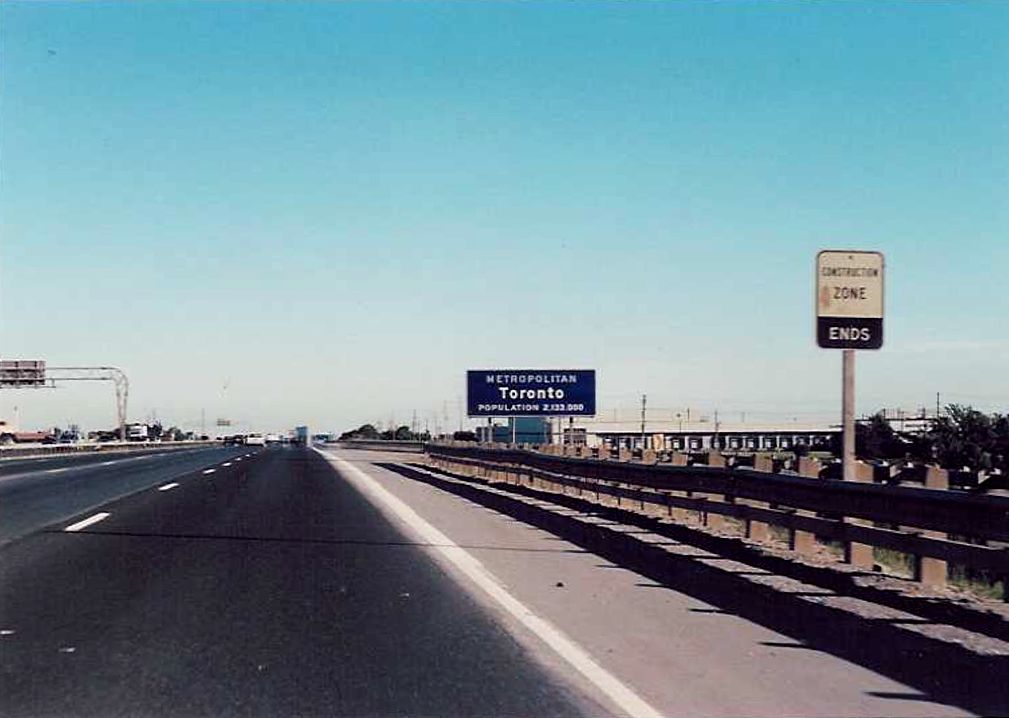
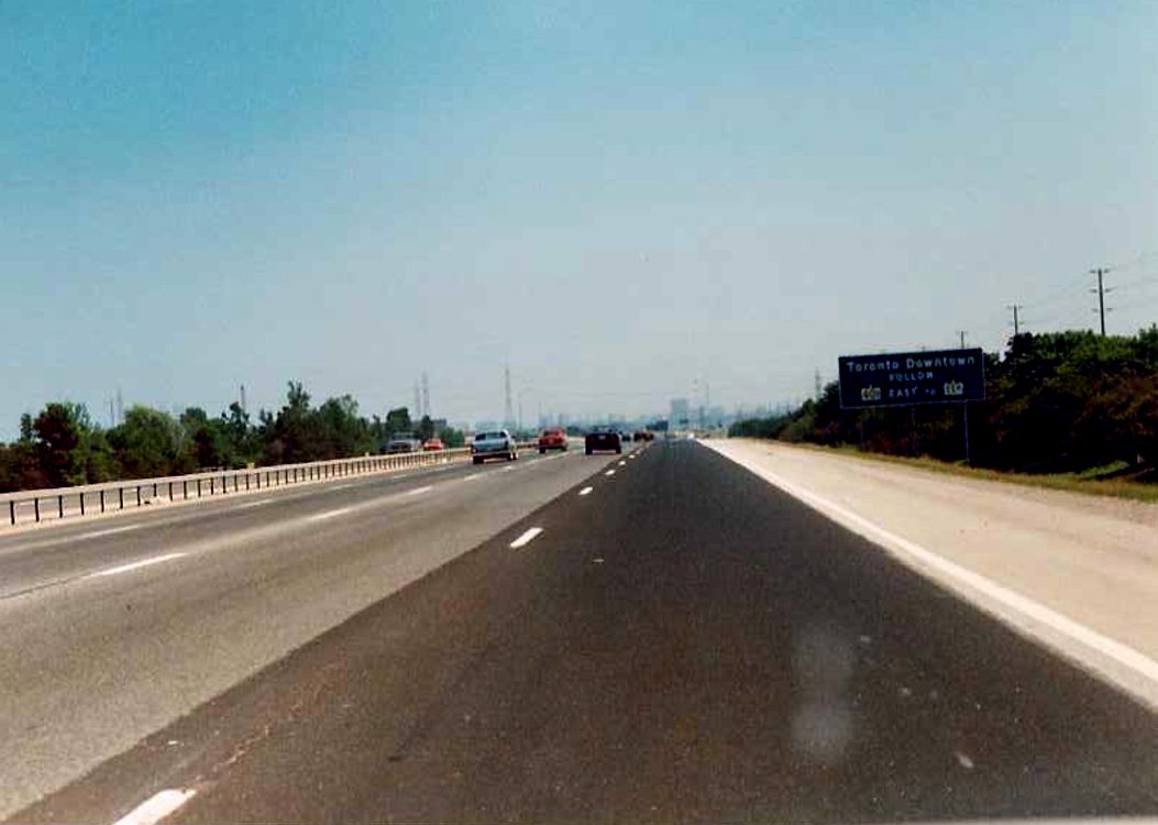
I went looking for old signs on the 400 series of highways, but I can't find anything for the former cities on the provincial roads. All I could find where signs for Metro:


These were from 1989 on the 400. I have some similarly old photos of the 401 and QEW, but I can't find any old signs for any of the former cities (and borough).
     
     
  #7248  
Old Posted Dec 31, 2018, 11:07 PM
Andy6's Avatar
Andy6 Andy6 is offline
Starring as himself
 
Join Date: Mar 2002
Location: Toronto Yorkville
Posts: 9,761
Quote:
Originally Posted by sonysnob View Post
I went looking for old signs on the 400 series of highways, but I can't find anything for the former cities on the provincial roads. All I could find where signs for Metro:

...

These were from 1989 on the 400. I have some similarly old photos of the 401 and QEW, but I can't find any old signs for any of the former cities (and borough).
I don’t remember any. It would have been unnecessary clutter on a highway like the 401.

On city roads there were sometimes a few, like the Borough of York sign at the foot of the Allen Road, announcing that it was the twin city of Aquila, Italy.
__________________
crispy crunchy light and snappy
     
     
  #7249  
Old Posted Jan 2, 2019, 2:06 PM
kxl kxl is offline
Registered User
 
Join Date: Dec 2015
Location: Winnipeg
Posts: 9
Quote:
Originally Posted by Acajack View Post
But it is also possible to head to Toronto on Hwy 417 west (via Hwy 7 from Carleton Place).
     
     
  #7250  
Old Posted Jan 2, 2019, 3:02 PM
sonysnob sonysnob is offline
Registered User
 
Join Date: Aug 2011
Posts: 1,797
^ Toronto is signed via Highway 7 from the 417:

https://goo.gl/nQaT8h
     
     
  #7251  
Old Posted Jan 2, 2019, 3:26 PM
Dengler Avenue's Avatar
Dengler Avenue Dengler Avenue is offline
Road Engineer Wannabe
 
Join Date: Sep 2017
Location: Côté Ouest de la Rivière des Outaouais
Posts: 8,669
Quote:
Originally Posted by sonysnob View Post
^ Toronto is signed via Highway 7 from the 417:

https://goo.gl/nQaT8h
I heard 7 was preferred over the oft-congested 2 before 401 was a thing. Perhaps that’s why? Also it’s bizarre that Peterborough isn’t signed. From Pet heading east, there will be a sign saying “Ottawa 279 km”.
__________________
My Proposal of TCH Twinning in Northern Ontario
Disclaimer: Most of it is pure pie in the sky, so there's no need to be up in the arm about it.
     
     
  #7252  
Old Posted Jan 3, 2019, 5:58 AM
swimmer_spe swimmer_spe is offline
BANNED
 
Join Date: Apr 2014
Posts: 10,743
Quote:
Originally Posted by Dengler Avenue View Post
Clarification: These are control cities as they should be.

Question though: There are so many cities that MTO will probably require 2 billboards instead of 1 due to sight line issues. Will that confuse people even more? Usually people will think the 2nd one’s just repeating what’s said on the 1st one in French.

401 east of Toronto needs to say the 4 cities in Durham Region first, before those 3. I’d still add Trenton in because of the CFB.
Highway 11 north leaving North Bay has 2 distance signs:
https://www.google.ca/maps/@46.3355161,-...C3gUDEOBdJTROIg!2e0!7i13312!8i6656?hl=en
     
     
  #7253  
Old Posted Jan 3, 2019, 6:01 AM
Dengler Avenue's Avatar
Dengler Avenue Dengler Avenue is offline
Road Engineer Wannabe
 
Join Date: Sep 2017
Location: Côté Ouest de la Rivière des Outaouais
Posts: 8,669
Quote:
Originally Posted by swimmer_spe View Post
Highway 11 north leaving North Bay has 2 distance signs:
https://www.google.ca/maps/@46.3355161,-...C3gUDEOBdJTROIg!2e0!7i13312!8i6656?hl=en
Very nice. One for immediate towns and another for farther major ones. Interesting that Hearst doesn’t make the list.
__________________
My Proposal of TCH Twinning in Northern Ontario
Disclaimer: Most of it is pure pie in the sky, so there's no need to be up in the arm about it.
     
     
  #7254  
Old Posted Jan 3, 2019, 12:17 PM
Acajack's Avatar
Acajack Acajack is offline
Gros Méchant Loup
 
Join Date: Aug 2006
Location: Province 2, Canadian Empire
Posts: 72,949
Quote:
Originally Posted by sonysnob View Post
^ Toronto is signed via Highway 7 from the 417:

https://goo.gl/nQaT8h
Yes, there is dumb, and then there is dumber.

So I assume at least some of those Russian or Brazilian tourists who don't instinctively know what the 401 is who miss the exit for the 416 5 km east of there, will take Highway 7 through the sticks to get from Ottawa to Toronto...

The worst is that this is all fairly new signage, installed after the 416 was completed.
__________________
Loin des yeux, loin du coeur.
     
     
  #7255  
Old Posted Jan 3, 2019, 12:57 PM
sonysnob sonysnob is offline
Registered User
 
Join Date: Aug 2011
Posts: 1,797
^ Why is that dumb? Highway 7 to Toronto is considerably shorter in distance than the routing via the 416.

https://www.google.ca/maps/dir/Toronto,+...d15ed!2m2!1d-75.6971931!2d45.4215296!3e0
     
     
  #7256  
Old Posted Jan 3, 2019, 1:04 PM
Acajack's Avatar
Acajack Acajack is offline
Gros Méchant Loup
 
Join Date: Aug 2006
Location: Province 2, Canadian Empire
Posts: 72,949
Quote:
Originally Posted by sonysnob View Post
^ Why is that dumb? Highway 7 to Toronto is considerably shorter in distance than the routing via the 416.

https://www.google.ca/maps/dir/Toronto,+...d15ed!2m2!1d-75.6971931!2d45.4215296!3e0
It's definitely a slower routing. (In addition to not being as safe.)

Directional signage should prioritize the fastest routes, not necessarily the shortest ones.
__________________
Loin des yeux, loin du coeur.
     
     
  #7257  
Old Posted Jan 3, 2019, 2:01 PM
The Chemist's Avatar
The Chemist The Chemist is offline
恭喜发财!
 
Join Date: Aug 2001
Location: 中国上海/Shanghai
Posts: 8,875
Quote:
Originally Posted by wave46 View Post
The US Interstate system is much better. An example: Interstate 10 in Phoenix lists the next western control city as Los Angeles, as opposed to some weird little place like Quartzsite, AZ.

The right way to do things IMO would be to list multiple control cities in order. A sign on Highway 401 in Scarborough would be have the cities of Kingston, Cornwall and Montreal listed in that order. A sign for Highway 2 north in Calgary would have Red Deer and Edmonton listed.
Chinese expressways are signed quite well, very similar to US Interstates. National Expressways (G expressways) typically list the terminal city of the expressway (particularly if it's Beijing or Shanghai) as well as the next provincial capital or other prefecture level city along the route. Provincial Expressways (S expressways) do tend to show smaller cities but the direction you need to go at a junction is typically very obvious regardless.
__________________
"Nothing is too wonderful to be true, if it be consistent with the laws of nature." - Michael Faraday (1791-1867)
     
     
  #7258  
Old Posted Jan 3, 2019, 3:30 PM
sonysnob sonysnob is offline
Registered User
 
Join Date: Aug 2011
Posts: 1,797
Quote:
Originally Posted by Acajack View Post
It's definitely a slower routing. (In addition to not being as safe.)

Directional signage should prioritize the fastest routes, not necessarily the shortest ones.
Highway signage should prioritize the most direct routes, not necessarily the most high speed ones.

Highway 7 is pretty comparable to most Toronto to Ottawa trips, particularly if the destination is anywhere in the north GTA. Google tends to overestimate travel times on two lane highways.

Is Highway 7 unsafe?
     
     
  #7259  
Old Posted Jan 3, 2019, 3:37 PM
sonysnob sonysnob is offline
Registered User
 
Join Date: Aug 2011
Posts: 1,797
Quote:
Originally Posted by The Chemist View Post
Chinese expressways are signed quite well, very similar to US Interstates. National Expressways (G expressways) typically list the terminal city of the expressway (particularly if it's Beijing or Shanghai) as well as the next provincial capital or other prefecture level city along the route. Provincial Expressways (S expressways) do tend to show smaller cities but the direction you need to go at a junction is typically very obvious regardless.
There is a lot of variability in US interstate signage between different states. For example, Los Angeles is the control city for I-10 west from Phoenix, but from Los Angeles, the eastbound control cities are first San Bernardino, Redlands and then Indio before finally switching to Phoenix once well into the Coachella Valley.
     
     
  #7260  
Old Posted Jan 3, 2019, 3:41 PM
Dengler Avenue's Avatar
Dengler Avenue Dengler Avenue is offline
Road Engineer Wannabe
 
Join Date: Sep 2017
Location: Côté Ouest de la Rivière des Outaouais
Posts: 8,669
Quote:
Originally Posted by sonysnob View Post
Highway signage should prioritize the most direct routes, not necessarily the most high speed ones.

Highway 7 is pretty comparable to most Toronto to Ottawa trips, particularly if the destination is anywhere in the north GTA. Google tends to overestimate travel times on two lane highways.

Is Highway 7 unsafe?
Not necessarily. But one slow driver in front of you doing less than 80 kph can piss you right off.
__________________
My Proposal of TCH Twinning in Northern Ontario
Disclaimer: Most of it is pure pie in the sky, so there's no need to be up in the arm about it.
     
     
This discussion thread continues

Use the page links to the lower-right to go to the next page for additional posts
 
 
Closed Thread

Go Back   SkyscraperPage Forum > Regional Sections > Canada
Forum Jump


Forum Jump


All times are GMT. The time now is 1:27 PM.

     
SkyscraperPage.com - Privacy Statement - Top

Powered by vBulletin® Version 3.8.7
Copyright ©2000 - 2026, vBulletin Solutions, Inc.