Quote:
Originally Posted by jmecklenborg

The Interstate system had nothing whatsoever to do with the military. It was simply a way to package a federal bill written by the automobile and oil industries. Recruiters use the interstates to drive to their strip mall offices, but otherwise, it serves no military purpose. Military equipment continues to be transported by the railroads that were built 100 years before the highways.
https://www.youtube.com/watch?v=HNJc_GU1wE4 |
Strategic Highways
During World War I, the Army quickly found that U.S. railroads could not serve its logistical needs and turned to truck convoys. Civilian motorists soon found that the convoy routes offered such unheard-of amenities as regular maintenance, snow plowing, and route markers.
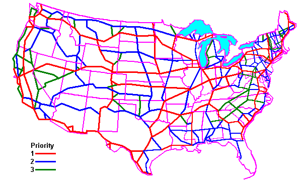
Shortly after the war, General Pershing proposed a national network of military and civilian highways. He ranked his routes by priority, shown here in red for highest priority, green for second and blue for third. The differences between this map and today's Interstate system are as interesting as the similarities. They reflect:
Military priorities: these were the days of Pancho Villa, who had raided into the U.S. in 1912; hence access to the Mexican border was a high priority. Note that there is no north-south link in Arizona. There is no link to Phoenix and Tucson is linked almost as an afterthought.
In an era before air power, attacks on the U.S. would come by sea if at all, so coastal routes are emphasized.
Technology: there is no Mackinac Bridge joining upper and lower Michigan on Pershing's map because the ability to build such a bridge was wholly beyond the technology of the day. Since Michigan consisted of two disconnected peninsulas with no easy surface connection, Michigan routes were of low priority.
Demographics: nobody at this time was very interested in traveling to Miami. Miami was little more than a village, and the only port of consequence on the Florida peninsula was Tampa. Defending southern Florida was of low priority because even if an enemy did land there, there were no roads suitable for moving an invasion force.
Economic Geology: access to coal fields is critical on Pershing's map, but not the oil fields of Oklahoma or west Texas, which had not yet been developed. Also there are numerous spurs to the iron ports on Lake Superior.
In 1919, the Army drove the first truck convoy across the United States, just to see if it could be done. It could, but only barely. The trip took several weeks. One of the participants was a young lieutenant named Dwight Eisenhower. Years later, as President, he signed the act creating the Interstate Highway System, officially called the Interstate and Defense Highway System. It looks very much like the network Pershing proposed. The fact that the system is the Interstate Defense Highway System accounts for the anomaly that Hawaii has Interstate highways: they connect all the major defense installations.
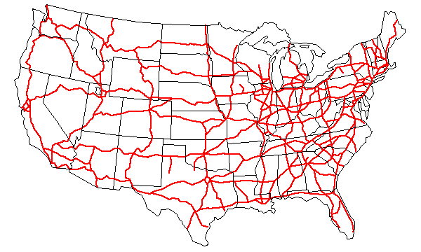
The first superhighways were in the U.S., and they in turn inspired the German Autobahn system, which mightily impressed the U.S. military during World War II. There had actually been plans for an American version in the 1930's, but World War II interrupted the plans. After the war, inspired in part by the Autobahns, Americans began building superhighways. So in reality, American and German superhighways inspired each other.
The U.S. love affair with the auto, with all its social and environmental impacts, would probably have happened anyway, but its actual development was strongly influenced by military considerations. It is all but impossible to overstate the environmental impact of the Interstate System. It is the largest engineering project in history.
http://www.uwgb.edu/dutchs/EnvirGeolNotes/Military.HTM





 Prev
Prev


 Linear Mode
