HomeDiagramsDatabaseMapsForum About
     

Go Back   SkyscraperPage Forum > Photography Forums > Found City Photos

Closed Thread

 
Thread Tools Display Modes
     
     
  #48501  
Old Posted Aug 25, 2018, 9:02 PM
HossC's Avatar
HossC HossC is online now
Registered User
 
Join Date: Aug 2013
Posts: 4,696
Quote:
Originally Posted by ethereal_reality View Post

'mystery' vantage point.

I've been trying to figure out where the photographer was standing when he/she took this slide back in 1967

"Amateur 35mm Original Slide 1967, Los Angeles Night Scene"


EBAY / no longer listed

As most of you know, the spectacular building on the right is the 17-story Dept. of Water and Power General Offices at 111 N. Hope Street. (it had opened two years prior to when this pic was taken)
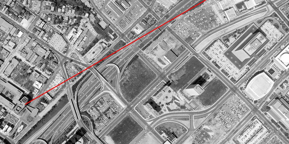
My guess would be the 1958 Union Oil Center/Unocal Center building. I've marked the rough line of signt below on a 1971 aerial view.


mil.library.ucsb.edu
     
     
  #48502  
Old Posted Aug 25, 2018, 9:07 PM
ethereal_reality's Avatar
ethereal_reality ethereal_reality is online now
Registered User
 
Join Date: Feb 2008
Location: Lafayette/West Lafayette IN, Purdue U.
Posts: 17,901
Giant Communion Wafer

'mystery' object.

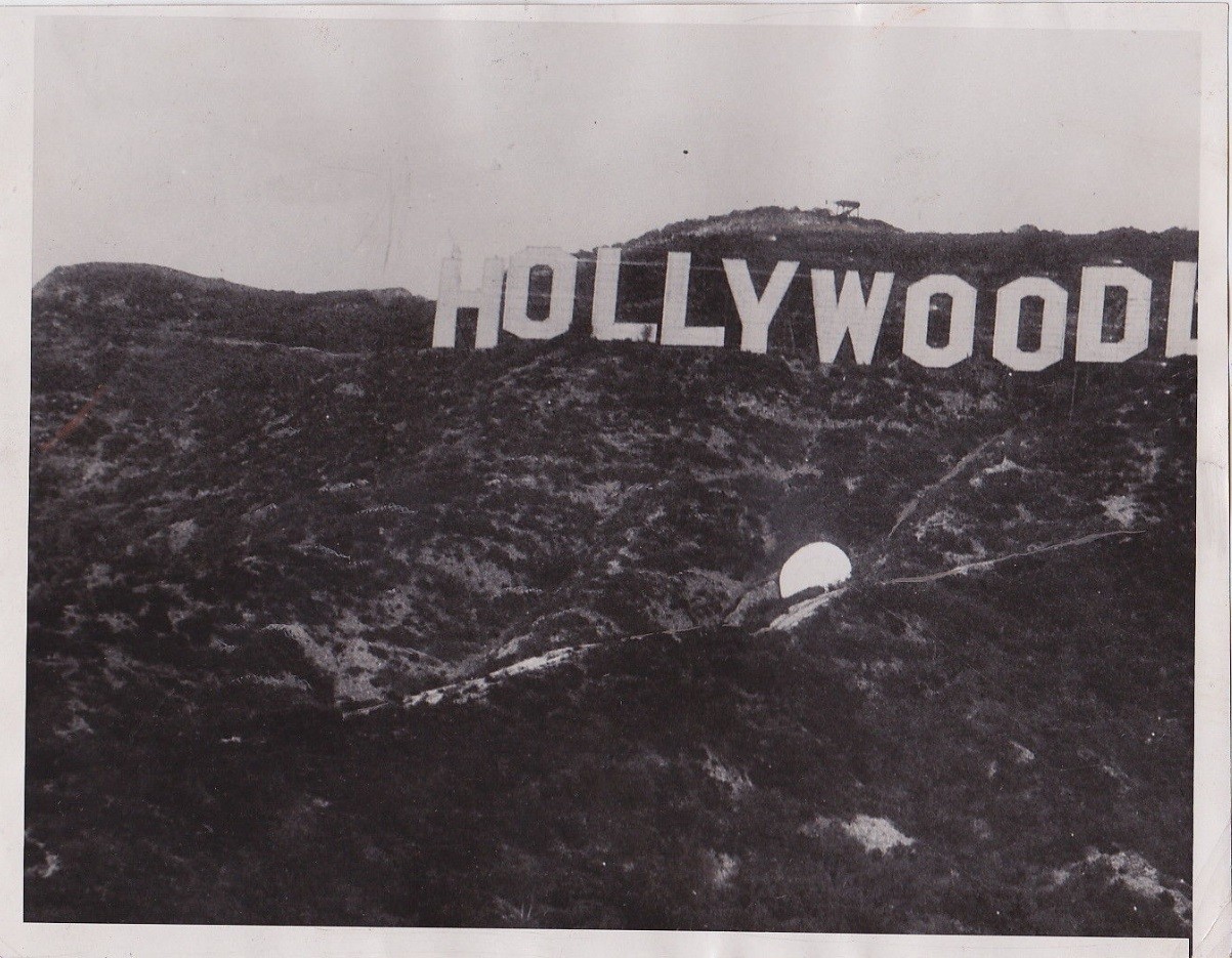
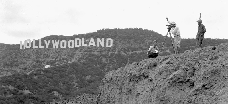
"Vintage Rare Classic 1932 Press Photo, Hollywoodland Sign Los Angeles"


EBAY

At first glance, I thought a dollop of white-out had landed on the photograph.


but if you take a closer look, there are trees and bushes in front of the object and a slight shadow on the rock behind it.


detail

Could it be a big PERIOD that was supposed to go at the end of the sign? (half kidding)


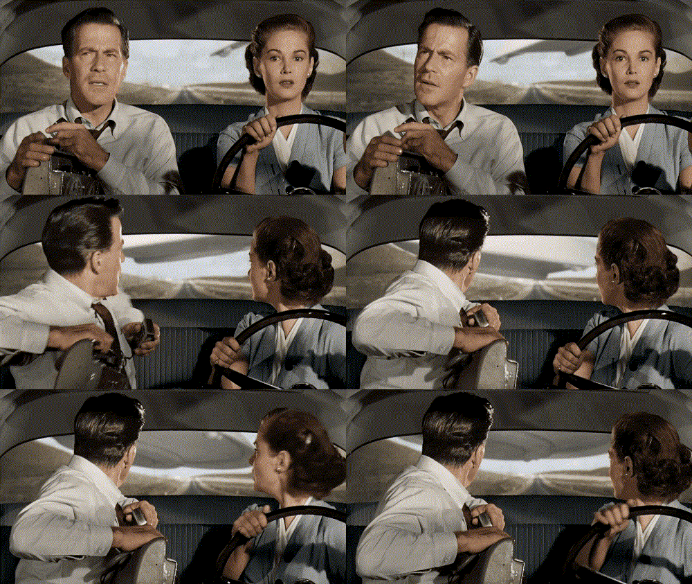
OR MAYBE......

earth vs the flying saucers 1956

___________________________________________________________


update:

Believe it or not, it shows up in other photographs as well.


cinemisery

Have we talked about this and I just forgot?


_
     
     
  #48503  
Old Posted Aug 25, 2018, 10:08 PM
HossC's Avatar
HossC HossC is online now
Registered User
 
Join Date: Aug 2013
Posts: 4,696


We discussed it nearly four years ago:

Quote:
Originally Posted by ethereal_reality View Post

'mystery spot'

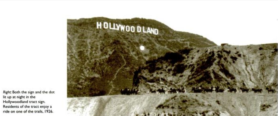
I've come across this photograph numerous times in the past and have always dismissed the spot as a quirky reflection, or a lens flare, or something of that order.
To my surprise the author below describes the 'dot' as a light that lit up along with the Hollywood sign.


http://www.storyofhollywood.com/

Is he correct? Is this actually a light of some sort?
Quote:
Originally Posted by HossC View Post

The story of the Hollywood(land) dot is corroborated by the articles below:

The legend of the Hollywood sign [Original link now dead] - "To add extra noticeability, a massive illuminated dot was added just beneath the sign as an exclamation point of sorts."

Why the Hollywood Sign Isn’t Lit (and Never Will Be) - "A searchlight below it lit up for emphasis, like an exclamation point."
Quote:
Originally Posted by ethereal_reality View Post

HossC, do you think this is the mystery 'dot'? (I can't believe they're calling it a 'dot')

I just found this on eBay.

http://www.ebay.com/itm/Hollywood-aka-Ho...?pt=Art_Photo_Images&hash=item20ec32ad09

I'm still a bit confused....was this 'dot' a searchlight/spotlight aimed at the Hollywoodland sign? -or was the Hollywoodland sign self-illuminated? -while this was just an illuminated 'dot'.
Quote:
Originally Posted by HossC View Post

Most of the articles I've read claim that 4000 electric light bulbs were used to illuminate the main sign, so I can't see the need for additional illumination from the dot. Apparently, the lights repeatedly flashed “Holly”, then “Wood” and finally “Land” before the whole sign lit up.

From www.hollywoodsign.org:

"Few know that a giant white dot (35 feet in diameter, with 20-watt lights on the perimeter) was constructed below the Sign to catch the eye. The Sign itself featured 4,000 20-watt bulbs, spaced 8 inches apart."

I found a video about the sign on YouTube. In Part 1: A History of the Hollywood Sign, 1923-2009, the contibutors discuss the sign's creation and the suicide of Peg Entwistle. The dot is described as "a searchlight that lit up like an exclamation point", but given the information above, I think the term "searchlight" is misleading, and it was just quite a bright dot.

Part 2: A History of the Hollywood Sign, 1923-2009 deals with the sign's restoration in the late-70s, and features Hugh Hefner talking about raising the funds to make it possible (he sponsored the "Y"). NB. Part 2 of the video doesn't appear to be available at the moment.
     
     
  #48504  
Old Posted Aug 25, 2018, 10:53 PM
BillinGlendaleCA BillinGlendaleCA is offline
Registered User
 
Join Date: Nov 2016
Posts: 570
Quote:
Originally Posted by Tourmaline View Post
Per GlendaleBill it may be more helpful to state that the Auto Wheel Cafe or similar was in "present day" Thousand Oaks. Newberry Park or Conejo Valley might be better starting points for a search since Thousand Oaks probably did not appear on many maps until the late '40s -'50s. The name evidently was decided by contest in the '20s, and as noted, the city was only incorporated in '64. https://www.toaks.org/departments/city-manager-s-office/public-information-office/history


If the business offered gas, food and lodging, as GlendaleBill pondered, it might have appeared on Auto Club "triptik maps of the period.


HWY 101 and Moorpark Rd., ~'62
https://i.pinimg.com/736x/61/09/06/610906774325613641e7c577d8d7d72b--gas-station-model-homes.jpg


Goebels Lion Park (present day - 2100 Thousand Oaks Blvd ?)
https://c1.staticflickr.com/8/7368/9011882456_84ac41cf49.jpg

https://web.archive.org/web/201206060456...ungleland_exhibit/jungleland_exhibit.htm

Jungleland went through several iterations but started out as Goebel's African Lion Park
https://web.archive.org/web/201203090511...oachmuseum.org/images/JL-JlandMap-LG.gif


http://tessa.lapl.org/cdm/singleitem/collection/photos/id/59245
I didn't know about the contest to name TO, but Newbury Park is a much older community than TO. That picture of Moorpark Road and TO Blvd brings back memories: you've got Dupar's at the upper left, then Conejo S&L, then across Moorpark, a gas station and then Treeland(the only nursery in town then) next to it and then across TO Blvd. some model homes for a Janss Real Estate development(their office was to the right just out of the frame.

I've been to Jungleland many, many times, we used to hear the lions and tigers from our house. They closed down in the late 60's and the property was vacant for a couple of decades. It's where the TO Performing Arts Plaza is now on TO Blvd. I went to the Stagecoach Inn last year for the tour(last time I'd been inside was the original building before it burned down) and they have some really good exhibits of Conejo Valley history(Jungleland, Conejo Valley Days...much of it I lived through).

Last edited by BillinGlendaleCA; Aug 25, 2018 at 11:15 PM.
     
     
  #48505  
Old Posted Aug 26, 2018, 12:06 AM
Tikiman's Avatar
Tikiman Tikiman is offline
Tikiman
 
Join Date: Jul 2017
Location: Seattle
Posts: 26
Quote:
Originally Posted by ethereal_reality View Post
Like this, odinthor?

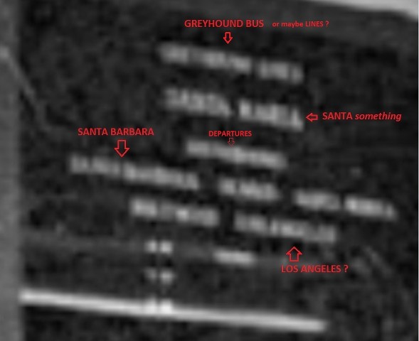
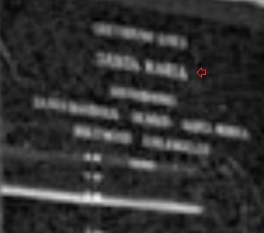
Could the one be Santa Isabel? It's just over the Mexican border.
     
     
  #48506  
Old Posted Aug 26, 2018, 1:56 AM
Scott Charles's Avatar
Scott Charles Scott Charles is offline
Registered User
 
Join Date: Jan 2018
Location: Los Angeles
Posts: 688
Quote:
Originally Posted by Tourmaline View Post
Per GlendaleBill it may be more helpful to state that the Auto Wheel Cafe or similar was in "present day" Thousand Oaks. Newberry Park or Conejo Valley might be better starting points for a search since Thousand Oaks probably did not appear on many maps until the late '40s -'50s. The name evidently was decided by contest in the '20s, and as noted, the city was only incorporated in '64. https://www.toaks.org/departments/city-manager-s-office/public-information-office/history

If the business offered gas, food and lodging, as GlendaleBill pondered, it might have appeared on Auto Club "triptik maps of the period.


Excerpt from 1913 So Cal Auto Club Map

http://digitallibrary.usc.edu/cdm/singleitem/collection/p15799coll59/id/339
Very interesting, Tourmaline, I did not know about the name change (a contest - wow!).

Is there any online archive of old Auto Club Triptik maps?

Quote:
Originally Posted by Tourmaline View Post
I just went through that entire flickr photo album. There was this interesting 1967 shot of the area in question (cropped below):

link

I also found this very large (6000 by 6000 pixel) image:

link


Quote:
Originally Posted by Tourmaline View Post
Now this is very interesting! I'd heard of the lion park before (in this thread) but I never put 2 and 2 together to realize that my father spoke of this place often.

My father (oddly enough) never mentioned any lions. But he did quite often talk about the “studio ranch in Thousand Oaks” where they “filmed the Tarzan movies”. Your link says:

Quote:
Many Hollywood producers also used Jungleland for the filming backdrops of many movies. Scenes from "Birth of a Nation," "Tarzan," and "The Adventures of Robin Hood" are some of the movies filmed here.


Apparently my father spent a lot of time on this “ranch”, working with my grandfather on various movies.

Quote:
Originally Posted by Tourmaline View Post
Wow, that looks very close to being the same car! I'm not much of a car guy, IS it the same car?

Many thanks for all of the great info, Tourmaline! It's great for me to discover the “studio ranch” my dad spoke of so often!
     
     
  #48507  
Old Posted Aug 26, 2018, 2:41 AM
Scott Charles's Avatar
Scott Charles Scott Charles is offline
Registered User
 
Join Date: Jan 2018
Location: Los Angeles
Posts: 688
Auto Wheel Cafe

I just stumbled across some information that one of my relatives sent me a while back. A photocopy of a letter was sent to me, but I never scanned it, since it wasn't a photo - I guess I subsequently forgot about it. Well, I just came across this photocopy now, and it includes a bit of information.

I've written about my great-uncle Hubert here before. He was a bit part actor, but primarily a stuntman. Here he is getting clobbered over the head by Oliver Hardy:


This is a photo of Hubert I never posted before. The letter I found today says that it was taken at the Auto Wheel Cafe:


Hubert's son Bert, the child on the right (above) is the young man on the left in the photo below, so the photo above would have been taken some time earlier.


I know that a photo of a man kneeling by an oak tree doesn't reveal much location information in a city literally called Thousand Oaks! But the letter (written by the son of Bert and the grandson of Hubert) says that he was taken to visit the tree, and that Bert said “we used to have a swing on that tree.” No date for this event is given, but I wonder if the tree outlived the cafe itself...
     
     
  #48508  
Old Posted Aug 26, 2018, 3:42 AM
Tourmaline Tourmaline is offline
Registered User
 
Join Date: May 2012
Posts: 996
Quote:
Originally Posted by Scott Charles View Post

Is there any online archive of old Auto Club Triptik maps?


I just went through that entire flickr photo album. There was this interesting 1967 shot of the area in question (cropped below):

link

I also found this very large (6000 by 6000 pixel) image:

link


Now this is very interesting! I'd heard of the lion park before (in this thread) but I never put 2 and 2 together to realize that my father spoke of this place often.

My father (oddly enough) never mentioned any lions. But he did quite often talk about the “studio ranch in Thousand Oaks” where they “filmed the Tarzan movies”. Your link says:


Apparently my father spent a lot of time on this “ranch”, working with my grandfather on various movies.


Wow, that looks very close to being the same car! I'm not much of a car guy, IS it the same car?


http://images.fineartamerica.com/images-...ssmuller-in-jungle-jim-silver-screen.jpg


We have had several Jungle Jim Weismuller posts, including one of mine: http://forum.skyscraperpage.com/showpost.php?p=7038928&postcount=28772. Whether or not he ever visited Monkey Island off of Cahuenga, he must have been familiar with it and possibly some of its inhabitants.

I have no idea what kind of records AAA keeps or, for that matter, whether their archival material is accessible and to whom. Of course many AAA photos and maps are available via the USC Digital Site, but one assumes AAA has their own treasure trove of archives. I am sure their membership information might be extremely interesting purely from historical perspective, similar to Census data and draft registration, except this data might include membership car ownership, etc. If you are a member, I suppose it might be worth a call.

When you mention "lion park," do not confuse it with the equally famous Gay's Lion Farm (Lincoln Park), in El Monte. NLA has posted many Gay's Lion Farm images. (See, e.g., http://forum.skyscraperpage.com/showpost.php?p=7740103&postcount=40552 ) Gay's evidently was on the decline at or after WWII. Jungleland survived until 1969. BRR posted a wonderful 1929 amusement map. http://forum.skyscraperpage.com/showpost.php?p=5717408&postcount=8035 Since the original Goebel's Lion Park didn't reportedly get started until 1927, it is unclear whether it is represented on the map, which is clearly not to scale. Curiously, the map refers to a Hollywd Zoo and Bird Wonderland near Encino on/off of Ventura Boulevard but east of the Ventura County line.

Both Lion venues reportedly have a connection with MGM's emblematic lion. https://www.kcet.org/shows/departures/el-montes-wild-past-a-history-of-gays-lion-farm http://www.weirdca.com/location.php?location=197 Another source claims "Leo" was interred at Jungleland. http://www.weirdca.com/location.php?location=197 One presumes that MGM made use of several lions from both locations.

Respecting the make, model and year of the car in your picture, I was unable to study the photo for any great degree of detail and wouldn't vouch for the '37 as being a match. However, I think it fair to say the car is prewar.

Note Uncle Bert's two tone shoes. Wingtips? Your Dad appears to be well dressed compared to his kin folk in the photo, he does not appear to be of military age, but all of them appear, to my untrained eyes, to be of high school age or younger. Did they attend school anywhere near the Auto Wheel Cafe, or where they visiting or helping out while on a school break? What was the dog's name and perhaps information regarding the dog might jog a few memories.


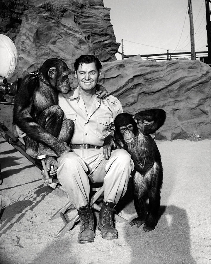
Tarzan and Superman?
https://ia.media-imdb.com/images/M/MV5BM...GdeQXVyMDMxMjQwMw@@._V1_SX640_SY720_.jpg

George and Johnny
https://ocdviewer.files.wordpress.com/2013/09/reeves-and-weissmuller.jpg


"Mr. Kent. watch out for Moon Men?"


https://www.moviemem.com/images/pictures/store/JUNGLE%20JIM/JUNGLEMOONMENLC5.jpg

Last edited by Tourmaline; Aug 26, 2018 at 4:01 AM.
     
     
  #48509  
Old Posted Aug 26, 2018, 4:12 AM
ethereal_reality's Avatar
ethereal_reality ethereal_reality is online now
Registered User
 
Join Date: Feb 2008
Location: Lafayette/West Lafayette IN, Purdue U.
Posts: 17,901
Quote:
Originally Posted by Tikiman View Post
Could the one be Santa Isabel? It's just over the Mexican border.
YES! Good suggestion Tikiman. That's definitely a L at the end of the word.


Does anyone know where to find old Greyhound bus routes or timetables?

__
     
     
  #48510  
Old Posted Aug 26, 2018, 4:50 AM
ethereal_reality's Avatar
ethereal_reality ethereal_reality is online now
Registered User
 
Join Date: Feb 2008
Location: Lafayette/West Lafayette IN, Purdue U.
Posts: 17,901
THE DOT


Quote:
Originally Posted by HossC
found this quote.
"Few know that a giant white dot (35 feet in diameter, with 20-watt lights on the perimeter)
was constructed below the Sign to catch the eye.
Let me get this straight: the developers thought people would notice the dot before they notice the thirteen 30 ft. TALL LETTERS that also lit up

AND THEN THERE'S THIS LINE
"A searchlight below the dot lit up for emphasis, like an exclamation point."

so one source says the dot was circled with lightbulbs and the other source says a spotlight was aimed at it. I wonder which source is correct.

Would one of you fine Los Angelenos hike up to there and see if there are any glass fragments? Thanks in advance.


_

Last edited by ethereal_reality; Aug 26, 2018 at 7:34 AM.
     
     
  #48511  
Old Posted Aug 26, 2018, 5:16 AM
ethereal_reality's Avatar
ethereal_reality ethereal_reality is online now
Registered User
 
Join Date: Feb 2008
Location: Lafayette/West Lafayette IN, Purdue U.
Posts: 17,901
Quote:
Originally Posted by Scott Charles

Here is my great-uncle Herbert getting clobbered over the head by Oliver Hardy:

Hey, your great-uncle is really good!


Giphy
     
     
  #48512  
Old Posted Aug 26, 2018, 6:08 AM
Scott Charles's Avatar
Scott Charles Scott Charles is offline
Registered User
 
Join Date: Jan 2018
Location: Los Angeles
Posts: 688
Quote:
Originally Posted by Tourmaline View Post
Note Uncle Bert's two tone shoes. Wingtips? Your Dad appears to be well dressed compared to his kin folk in the photo, he does not appear to be of military age, but all of them appear, to my untrained eyes, to be of high school age or younger. Did they attend school anywhere near the Auto Wheel Cafe, or where they visiting or helping out while on a school break? What was the dog's name and perhaps information regarding the dog might jog a few memories.
The cute little pup? Gosh, I have absolutely no idea!

As for my father, he attended Fairfax High School on Melrose. I would assume this would apply to his younger brother Jack, as well. My dad's family moved around quite a bit, but as far as I know, they were always in Hollywood or the general vicinity.

As for Hubert and his son Bert, I have no idea where they lived, nor do I have any idea where Bert went to school... possibly in Thousand Oaks?

The photograph is absolutely pre-war, as both my father and Jack served in the military during the war.

Quote:
Originally Posted by ethereal_reality View Post
Hey, your great-uncle is really good!


Giphy
Thanks, ER! I don't know how they did those Sennett style pratfalls without killing themselves!

The movie was called The Live Ghost, it came out in 1934, and here is Hubert's credit for the movie on IMDB: https://www.imdb.com/title/tt0025413/characters/nm0227126?ref_=ttfc_fc_cl_t8

Hubert was also in a number of Three Stooges features, as noted here. Here he is in Mr. Noisy (he's the ice cream man):


Hubert was also the (unseen) tractor driver in one of my favorite Our Gang features, 1936's Divot Diggers:


  #48513  
Old Posted Aug 26, 2018, 6:47 AM
ethereal_reality's Avatar
ethereal_reality ethereal_reality is online now
Registered User
 
Join Date: Feb 2008
Location: Lafayette/West Lafayette IN, Purdue U.
Posts: 17,901
Quote:
Originally Posted by odinthor View Post
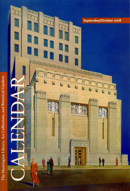
618 S. Spring Street, the Los Angeles Stock Exchange Building facade, 1929, Samuel E. Lunden.


Cover, Calendar, Huntington Library, September-October, 2018.
Thanks for posting this odinthor. It's been a looong time...years even...since we visited the Los Angeles Stock Exchange Building on NLA.


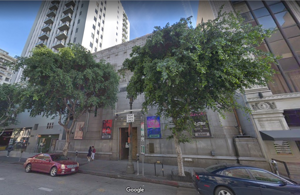
I think the average person might not even know it's there because it's rather difficult to see.


GSV

I know GW...the trees! the trees!
so you don't have to


Anywhoo...
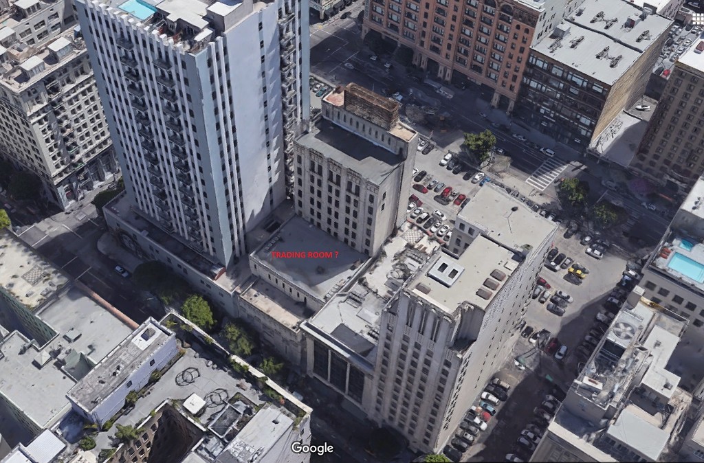
The tower portion of the building is so far back on the property it's virtually impossible to see from anywhere along Spring Street.

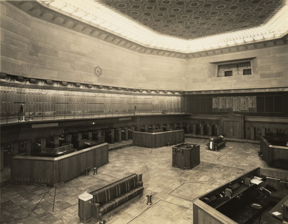
I think the architect had to avoid building it over the massive trading room floor.


The trading room sans support columns.


They didn't want the tower to come crashing through the trading room ceiling. (I'm kinda' making this up)

and speaking of crashes...the 'Great Crash' happened three days after construction began. (true!)

__

Last edited by ethereal_reality; Aug 26, 2018 at 9:12 AM.
     
     
  #48514  
Old Posted Aug 26, 2018, 7:59 AM
Noir_Noir Noir_Noir is offline
Registered User
 
Join Date: Feb 2018
Posts: 600
re The Auto Wheel Cafe

On the off chance Scott Charles that you have not found these references before.


newspaperarchive.com - Oxnard Daily Courier - 1936/37


The top one links Emma Diltz to a gas/service station in Thousand Oaks in 1936. But does it refer to the Auto Wheel Cafe? And where to look to turn that

Thousand Oaks Tract - Lot 4, Block 46

into an identifiable location and address.


I had a brief thwarted effort on this City Of Thousand Oaks/Ventura County assessor's interactive map -

City Of Thousand Oaks - Online Map

For some reason it's making my browsers lock up.

From my short foray, I don't think it'll bear fruit and it's likely a case of having to locate the old maps or record books.
     
     
  #48515  
Old Posted Aug 26, 2018, 8:12 AM
Scott Charles's Avatar
Scott Charles Scott Charles is offline
Registered User
 
Join Date: Jan 2018
Location: Los Angeles
Posts: 688
Quote:
Originally Posted by Noir_Noir View Post
On the off chance Scott Charles that you have not found these references before.


newspaperarchive.com - Oxnard Daily Courier - 1936/37


The top one links Emma Diltz to a gas/service station in Thousand Oaks in 1936. But does it refer to the Auto Wheel Cafe? And where to look to turn that

Thousand Oaks Tract - Lot 4, Block 46

into an identifiable location and address.


I had a brief thwarted effort on this City Of Thousand Oaks/Ventura County assessor's interactive map -

City Of Thousand Oaks - Online Map

For some reason it's making my browsers lock up.

From my short foray, I don't think it'll bear fruit and it's likely a case of having to locate the old maps or record books.
WOW. I have decidedly NOT seen that before - thank-you, Noir_Noir!

The map does work for me (though it's slow as molasses). But what, exactly, am I trying to find on it?

Here is the general location on the map, please click on it to see it full-sized:


  #48516  
Old Posted Aug 26, 2018, 8:27 AM
BillinGlendaleCA BillinGlendaleCA is offline
Registered User
 
Join Date: Nov 2016
Posts: 570
Quote:
Originally Posted by Scott Charles View Post
Very interesting, Tourmaline, I did not know about the name change (a contest - wow!).

Is there any online archive of old Auto Club Triptik maps?


I just went through that entire flickr photo album. There was this interesting 1967 shot of the area in question (cropped below):

link

I also found this very large (6000 by 6000 pixel) image:

link
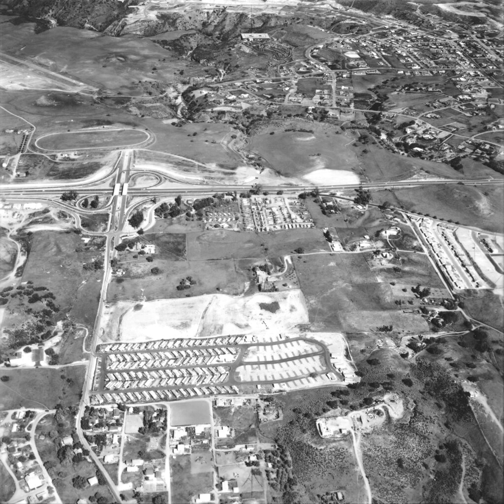
Scott Charles, for obvious reasons I follow the "Conejo though the Lens" Flickr group. I looked at the uncropped version of first photo that you linked to above and saw some additional things. Here's the uncropped version:

Ventu Park aerial, 1967 by Conejo Through the Lens, on Flickr

At the top left is Rancho Conejo Airport which was used in the film "It's A Mad, Mad, Mad World". At the top center is the Rockwell Science Center, which was a basic research facility for North American Rockwell(you can see it's large rectangular roof). The recently moved Stagecoach Inn is to the bottom left, it's a bit hard to see, but the new asphalt on it's parking lot really stands out.

You mentioned that some of your family may have attended school in the TO area. There was one school in the valley that dates back to the late 1800's called Timber School(a replica of the original schoolhouse is next to the Stagecoach Inn). Timber School was a bit west down Newbury Road from Ventu Park. In the 1920's a second school was established near the older portion of Thousand Oaks called Conejo School.
     
     
  #48517  
Old Posted Aug 26, 2018, 12:08 PM
GaylordWilshire's Avatar
GaylordWilshire GaylordWilshire is offline
Registered User
 
Join Date: Nov 2009
Location: NYC
Posts: 3,706
Quote:
Originally Posted by HossC View Post
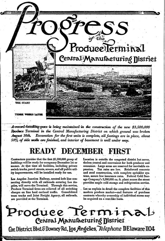
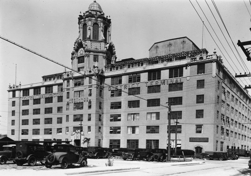
Although not seen in the recently posted detail views, the Central Manufacturing District Terminal building appears under the "Pro" of "Produce" at the top of the original artwork (below). It was already standing in the August 1, 1927 aerial I posted a couple of pages back. Having said that, the towers and flag poles on the mystery building certainly fit with the other buildings in the CMD. It's a shame that it looks like it was never built.


You are right again, Hoss-- the evidence was right in front of me.

Here's more--an ad from the Times, Sept 21, 1927:


As for the CMDT--any idea what the boxlike structure on top is--the one with the three cross-shaped grilles? A chapel??


  #48518  
Old Posted Aug 26, 2018, 12:18 PM
CityBoyDoug CityBoyDoug is offline
BANNED
 
Join Date: Apr 2013
Posts: 2,868
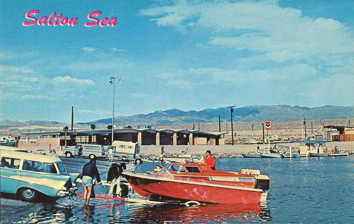
Boats being launched at the once popular Salton Sea in the 1960 era.


The Sea was a badly managed recreation site. Its now more like a dead sea.

Last edited by CityBoyDoug; Aug 26, 2018 at 2:16 PM.
     
     
  #48519  
Old Posted Aug 26, 2018, 2:37 PM
Tourmaline Tourmaline is offline
Registered User
 
Join Date: May 2012
Posts: 996
Quote:
Originally Posted by Noir_Noir View Post
On the off chance Scott Charles that you have not found these references before.


newspaperarchive.com - Oxnard Daily Courier - 1936/37

The top one links Emma Diltz to a gas/service station in Thousand Oaks in 1936. But does it refer to the Auto Wheel Cafe? And where to look to turn that Thousand Oaks Tract - Lot 4, Block 46 into an identifiable location and address.
Further on the Oxnard Courrier, the first '36 issue perused https://newspaperarchive.com/oxnard-daily-courier-aug-01-1936-p-1/ had a small classified ad reading:
Quote:
Goebel's African Lions
Farm will buy horses. Phone 189 Oxnard or Pacific Long Distance Thousand Oaks.
Unclear what purpose the horses would serve considering condition or age was not mentioned in the ad. Yum yum. The phone services obviously recognized the "Thousand Oaks" moniker and since real estate was part of a Thousand Oaks tract, the legal description was referenced in legal notices. Exactly when the name became commonly used by non-locals (Angelinos), remains uncertain. BTW, an ad for a "5" cu ft Electrolux water cooled refrigerator ($75 cash) illustrates that during the depression, appliances we now take for granted, had significant value. (Curious if this is a glorified swamp cooler with a wooden slat covered tower, as seen on many market roof tops - or a glorified ice box, discussed recently on NLA.)

Advertising food and petrol might have been a luxury for a business that probably catered to big city travelers. This might explain the lack of any Auto Wheel Cafe ads, although my search may not have been exhaustive. At a penny per word per day, the costs would ad up, especially in the '30s. There are at least 26 "Diltz" references that mention mundane events, e.g., hosting in-laws, "motoring to Santa Monica" and, many other things.

In May '37, Hubert Diltz Jr., provided a Conjeo Grammar School graduation address. https://newspaperarchive.com/oxnard-daily-courier-may-29-1937-p-4/

Grandma Diltz evidently passed away during the war and as reported on April 8, 1944, title of the property was transferred from her estate,https://newspaperarchive.com/oxnard-press-courier-apr-08-1944-p-5/

Best I can do on decaf.

Last edited by Tourmaline; Aug 26, 2018 at 7:14 PM.
     
     
  #48520  
Old Posted Aug 26, 2018, 6:30 PM
ProphetM ProphetM is offline
Registered User
 
Join Date: Jul 2012
Posts: 509
Quote:
Originally Posted by Scott Charles View Post
Thank you for taking the time to explain all of that to me, Bill - it truly is appreciated!

I didn't know that the 101 existed before it became a “freeway”. I was a bit confused when you said that Newbury Road possibly was the 101... but I just Googled a number of articles online, and I believe that I understand it now. The 101 is officially a route, much like Route 66, and not an interstate highway, like the I-5 or the I-10. And before that, it was El Camino Real. Whew!
I am rather completely surprised that you didn't know this! Maybe I'm too involved in the roadie community to know what is common knowledge outside that group.

The US Highway system was created in 1926, and US 101 was among the original routes created upon its inception (as was US 66). They were generally composed of local roads that already existed, signed to form long routes, and then often later upgraded piecemeal to larger highways, expressways or freeways over time. North-south routes are odd-numbered with major routes ending in 1, starting with US 1 on the east coast. East-west routes are even-numbered and starting in the north. When the interstate system was established, they reversed the starting points to avoid conflicts, which is why their numbers run west-to-east and south-to-north.

The interstates replaced many US Highways, with the older roads getting truncated, eliminated, or re-designated as state highways, such as US 99 which was replaced by I-5 and became CA-99, US 91 which was replaced by I-15 and largely ceased to exist, US 66 which was replaced by I-40 and I-44 and reverted to local roads and county-numbered 66, etc.

US 101 is one of the lucky ones, having been mostly not replaced by an interstate, except south of Los Angeles where it was replaced by I-5.
     
     
This discussion thread continues

Use the page links to the lower-right to go to the next page for additional posts

Closed Thread

Go Back   SkyscraperPage Forum > Photography Forums > Found City Photos
Forum Jump


Forum Jump


All times are GMT. The time now is 8:42 PM.


Powered by vBulletin® Version 3.8.7
Copyright ©2000 - 2026, vBulletin Solutions, Inc.