I am so happy to hear of reform bills making their way through the legislature. Hopefully something gets passed this year. I can't afford another heartbreak like the
Ranked Ballot Vote bill last year.

So, to keep me give me something to do other than be nervous, here is the rest of my East-West commuter rail idea. We've gone from Tooele to Salt Lake Central to Park City, but I think there is more utility that can be wrung out from such an alignment. By making it an X, with Salt Lake Central in the middle, we could add two more locations: the Airport and the Cottonwood Canyons.
For the airport segment I got lazy. In the Google Map I show an elevated line crossing overtop of the spaghetti bowl and parking lots, ending up near the Welcome Center in the parking structure like the old elevated TRAX line would have, except on the west side rather than the east. I took licence to do this from Toronto's
Union-Pearson Express, a 'light commuter rail' that runs to the airport in a traditional railroad ROW, with the last 2 miles being on a double-track elevated structure.


There's probably a better way to do it - such as potentially sharing some of the TRAX line into the airport property - but with the airport still under construction and so much up in the air I didn't bother to think too hard about the actual alignment. Instead, here are some arguments in favor of building
another rail line to the airport:
- One-seat ride to Salt Lake Central Station, Sugarhouse, and Foothill Drive
- One-seat ride to Park City
- One-seat ride to the Cottonwood Canyons
- A faster express service between FrontRunner and the airport. (10-ish minutes vs 20-ish minute trip times)
- Contingency route in case something blocks the street-running North Temple TRAX line.
- Capacity, as two lines can move more people per hour than a single line.
- Division of local use vs express use
*-*-*-*-*-
The final leg of the 'X' will go out to the Cottonwood Canyons. This line will branch off of the main I-80 line just beyond the Foothill Drive station, so that both the Park City and Cottonwood trains can stop at that BRT station.
I've drawn my junction between the two lines like this:

At that location, the elevation difference between I-80 and I-215 is enough to allow the branch lines to sink down below I-80, cross underneath the eastbound side, then enter a bridge over the northbound lanes of I-215 before descending into the median of that freeway. All in all, it'll cost about the same as a normal freeway junction.
From here the line runs south, making two intermediate stops. The first I've drawn in at 39th South:

The second will be at about 62nd South. At this point the line will have crossed over to the east side of I-215 on some sort of grade-separation, either a bridge or tunnel over or under the northbound lanes of I-215. The station itself will be built on the north side of Big Cottonwood Road, right across from the business park:

The line will then proceed for the last half-mile along the north and east side of Big Cottonwood Road until reaching the Quarry site, which is where the Cottonwood Canyons Transportation Center will be built:

This is a facility for people to park their cars or arrive by transit, then cross through a plaza that connects them to shuttle buses to either Big or Little Cottonwood Canyons. There will be visitor's centers on either side of the plaza, like a national park, and perhaps event spaces and whatnot.
The inspiration for this is, of course, Zion National Park, where visitors can park their cars or ride the free public buses from their hotels to the visitors center, then board the shuttle buses into the park:
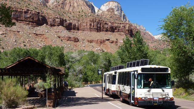
The shuttle buses up the Cottonwood Canyons can be paid for by a small toll for regular vehicles in the canyons. Banning private vehicles from the Cottonwood Canyons is a bad idea; in fact banning anything is probably a bad idea, just price it so that it becomes a manageable problem.
A toll appears to be in the works anyway, so why not use it to pay for something that will actually be a useful alternative to sitting in traffic? Shuttle buses are needed, and in order for them to work, they need to have a place where people can park their cars or transfer from public transit and get on board. Hence the Cottonwood Canyons Transportation Center.
I've also drawn in some commercial areas in the back of the center, because I don't think that the construction and upkeep of the Transportation Center can or should be paid for on its own. This would be a public-private partnership, where the fees paid by the hotel/commercial developers and operators would pay for the construction and upkeep of the public facilities.
There is all kinds of demand for hotels closer to the cottonwood canyons, and these hotels would likely be high-end resorts. That's OK, so long as the public gets some benefit too. I think that free shuttles to the Cottonwood Canyons are a fair trade for allowing private companies to build so close to the canyons.
I estimate that a rail line like this could get you from Salt Lake Central Station to the Cottonwood Canyons Transportation Center in about half an hour. A train from Park City could connect to the CCTC in about 45 minutes. Imagine how friendly this would be for tourists - they could board a train at the airport, be taken in a one-seat ride to either Park City or the Cottonwood Canyons, and then take a day trip to the other side of the Wasatch Mountains all on the same train. Do I need to spell out how fantastic it would be?
This is the sort of thing, IMO, that should be in the long-range plans rather than talk of a narrow-gauge cog railway into the canyons, or tunnels under the mountains. Those projects have some merit, but by building in Freeway medians and going around the mountains, we can serve so many more destinations, and do so more conveniently, than if we focus just on tunnels.
If you're interested, check out the linked Google Map in my signature line for the entire alignment.





 Prev
Prev


 ), I hope we can at least do this.
 If a train comes every minute at those stations, then each line could have a peak frequency of 5 minutes. I like this idea a lot. I wish UTA could get rid of their time-tables and schedules and just follow this rule: during Rush Hours, all trains and buses run every 5 minutes. During daytime off-peak hours, all trains and buses run every 10 minutes. During late-evening/early-morning off-peak hours, all trains and buses run every 15 minutes. That way nobody needs to memorize any schedule, and UTA can run buses and trains at whatever frequency is required to handle the travel demand. Elevators do not run on set schedules, transit should not either.

 Linear Mode
