HomeDiagramsDatabaseMapsForum About
     

Go Back   SkyscraperPage Forum > Regional Sections > Canada > Alberta & British Columbia > Vancouver > Downtown & City of Vancouver


Reply

 
Thread Tools Display Modes
     
     
  #1001  
Old Posted Dec 11, 2017, 9:16 PM
Vin Vin is offline
Registered User
 
Join Date: Sep 2013
Posts: 8,739
People keep forgetting that we need the available roadspace for future increase in transit vehicles. What makes cities like Hong Kong, London, Singapore, etc great as good public transport cities? Look at the roads: buses seem to stream down constantly. You need ample roadspace for dedicated bus lanes to achieve that. As we densify our urban areas, it would make sense that there will be more shuttle buses to service the new neighbourhoods and connect them to streetcar or skytrain stations. Removing roadways is not the answer, especially around the northest part of Falsecreek and the surrounding areas, which are going to see great density increases in the near future.

Oxford Street, London:

https://www.google.ca/maps/@51.5147627,-...vpXaZZiYmAeAbeS7Q3SBg!2e0!7i13312!8i6656
Reply With Quote
     
     
  #1002  
Old Posted Dec 11, 2017, 10:19 PM
WarrenC12's Avatar
WarrenC12 WarrenC12 is offline
Registered User
 
Join Date: May 2007
Location: East OV!
Posts: 24,737
Quote:
Originally Posted by Vin View Post
Great example. It's one lane each direction, with only buses, cabs and bicycles. Is that your ideal future?
Reply With Quote
     
     
  #1003  
Old Posted Dec 11, 2017, 10:20 PM
Migrant_Coconut's Avatar
Migrant_Coconut Migrant_Coconut is offline
Registered User
 
Join Date: Oct 2015
Location: Kitsilano/Fairview
Posts: 10,187
It's not like we're running buses on the Viaducts now - not to mention that as discussed in other threads, transit works best when off the road. The best thing to do right now is advocate for a wide Pacific Boulevard and Malkin/National Connector, and for a streetcar and Hastings SkyTrain that prevents that from filling up immediately on Day 1.
Reply With Quote
     
     
  #1004  
Old Posted Dec 12, 2017, 12:13 AM
Changing City's Avatar
Changing City Changing City is offline
Registered User
 
Join Date: Nov 2016
Posts: 8,349
Quote:
Originally Posted by WarrenC12 View Post
Great example. It's one lane each direction, with only buses, cabs and bicycles. Is that your ideal future?
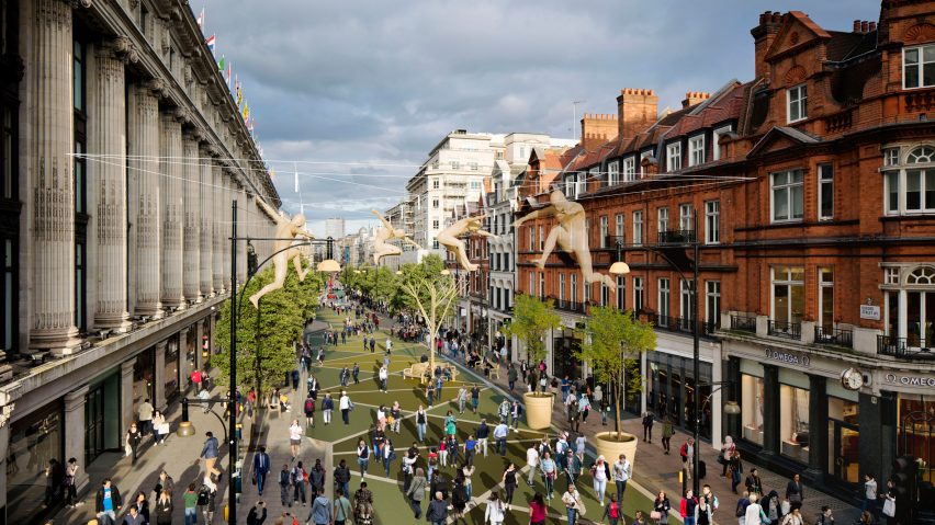
Even better - next year they plan to remove the buses as well...


(source: dezeen)
Reply With Quote
     
     
  #1005  
Old Posted Dec 12, 2017, 6:10 AM
Vin Vin is offline
Registered User
 
Join Date: Sep 2013
Posts: 8,739
Quote:
Originally Posted by WarrenC12 View Post
Great example. It's one lane each direction, with only buses, cabs and bicycles. Is that your ideal future?
I knew you would pick on that and say something irrelevant. FYI, there are multiple roads parallel to Oxford street able to handle other vehicles, and some of these roads have steams of buses too: no dedicated bike lanes. Certainly bikes, although not many, share Oxford street with so many buses on it. The shear number of buses makes driving unnecessary.
Reply With Quote
     
     
  #1006  
Old Posted Dec 12, 2017, 6:12 AM
Vin Vin is offline
Registered User
 
Join Date: Sep 2013
Posts: 8,739
Quote:
Originally Posted by Migrant_Coconut View Post
It's not like we're running buses on the Viaducts now - not to mention that as discussed in other threads, transit works best when off the road. The best thing to do right now is advocate for a wide Pacific Boulevard and Malkin/National Connector, and for a streetcar and Hastings SkyTrain that prevents that from filling up immediately on Day 1.
That's because we aren't even close to being densely built like many other great cities. One day we would and we need the road space.

Quote:
Originally Posted by Changing City View Post
Even better - next year they plan to remove the buses as well...


(source: dezeen)
Do you know there is a high capacity tube system directly beneath Oxford street? There are also multiple cross tube trains along the entire stretch. Buses will simply be moved to the next streets, which have not seen any lane reductions.
Reply With Quote
     
     
  #1007  
Old Posted Dec 12, 2017, 6:43 AM
Changing City's Avatar
Changing City Changing City is offline
Registered User
 
Join Date: Nov 2016
Posts: 8,349
Quote:
Originally Posted by Vin View Post

Do you know there is a high capacity tube system directly beneath Oxford street? There are also multiple cross tube trains along the entire stretch. Buses will simply be moved to the next streets, which have not seen any lane reductions.
Your statement started "People keep forgetting that we need the available roadspace for future increase in transit vehicles." Then you offered Oxford Street as an example. Clearly London doesn't think they need the available roadspace for future increase in transit vehicles.

Having worked on Oxford Street at one time, I'm possibly more familiar with it than you seem to be. There actually aren't many alternate streets to divert buses to. Bus passengers will be forced to use trains because a lot of bus routes are going to be cut short. Transport for London is effectively giving up on the nine bus routes that currently travel along Oxford Street. Only two will be re-routed to the nearest parallel street north, while two more will be routed away from the area entirely.

In the case of Northeast False Creek the City are replacing one short route with another that will have more capacity than it does today. Combined there should be enough capacity for the traffic that currently exists. That traffic will have more options about finding alternatives that don't exist today, because you can't turn off the viaducts if an incident occurs. Traffic isn't expected to go up overall, it's expected to stay around the same. That doesn't seem unreasonable because as SFU showed, traffic volumes didn't go up in the 2000s, and as the census showed, the number of people driving to and from work (mostly during the peak travel times) actually went down in the City of Vancouver, although there were 35,000 more people travelling to work.

Reply With Quote
     
     
  #1008  
Old Posted Dec 12, 2017, 7:07 AM
SFUVancouver's Avatar
SFUVancouver SFUVancouver is offline
Registered User
 
Join Date: Dec 2006
Location: Hamilton
Posts: 6,731
Quote:
Originally Posted by cornholio View Post
This is what percentage of people use what mode of transit to get to/from"work". The region and city has grown considerably, the city has not improved road infrastructure at all and in fact has constrained it in the listed years. There is no real room for growth during peak periods (which is really what these numbers are looking at). So as the city grows the percentages of people driving goes down, and that's fine. However that tells us nothing about the need for roads, and the demand for driving. So the point still stands. Demand is higher and it has not gone anywhere. People should be given options. As transit is improved, especially in the core, so too should roads be improved and bi-passes. That's how cities grow.


Vehicle ownership has been growing year over year in this region along with vehicle use. Only modes of travel during work commuting hours (peak rush hour) have been stagnating in total numbers due to congestion with a near zero investment in infrastructure. That should come as no surprise. The region needs to invest more in road and highways at the same time as it invests in transit. Yes you most definitely can build your self out of congestion by providing people options. The viaducts are not down yet and there is plenty of corruption to be uncovered in the entire debacle that someone can do if they so please, enough — that it would shut down the entire process overnight and burn through city council and various servants like a wild fire.
Commuting to work stats are the golden standard for transport planning for a CBD/downtown district, so they are definitely relevant. Furthermore, the screenline count data are trip-purpose-agnostic; they just count vehicle movements.

I really don't understand some people's response to this information. Metro Vancouver in general, and the City of Vancouver in particular, is doing a great job moving the needle on mode share. The StatsCan data confirms a success story playing out and some see it as bad news; the carpocalypse is imminent.
Reply With Quote
     
     
  #1009  
Old Posted Dec 12, 2017, 7:13 AM
Hourglass Hourglass is offline
Registered User
 
Join Date: Jun 2006
Location: Here and there
Posts: 754
Quote:
Originally Posted by Vin View Post
Do you know there is a high capacity tube system directly beneath Oxford street? There are also multiple cross tube trains along the entire stretch. Buses will simply be moved to the next streets, which have not seen any lane reductions.
Not a great example IMHO. I used to work in Soho just off Oxford Street, and I really can't think of any other parallel streets for buses to move to. And if you've ever driven in central London, you'll know that traffic is awful to begin with.

The reason they probably feel they can close Oxford Street is likely due to Crossrail which opens up in a couple of years time. But either way, there's still a lot of pressure on existing east-west underground lines
Reply With Quote
     
     
  #1010  
Old Posted Dec 12, 2017, 4:17 PM
WarrenC12's Avatar
WarrenC12 WarrenC12 is offline
Registered User
 
Join Date: May 2007
Location: East OV!
Posts: 24,737
Quote:
Originally Posted by Vin View Post
That's because we aren't even close to being densely built like many other great cities. One day we would and we need the road space.

Do you know there is a high capacity tube system directly beneath Oxford street? There are also multiple cross tube trains along the entire stretch. Buses will simply be moved to the next streets, which have not seen any lane reductions.
One thing that will get us closer to your dense utopia is the redevelopment of NEFC.

As for high capacity, we have a Skytrain line running above instead of below the street in the viaduct area. If we get a streetcar to compliment that, we'll have plenty of capacity for moving people. Other posters have done a great job describing what's happening in London, and what's happening in NEFC. The sky is not falling.
Reply With Quote
     
     
  #1011  
Old Posted Dec 28, 2017, 5:57 AM
Feathered Friend Feathered Friend is offline
Registered User
 
Join Date: Jun 2016
Posts: 2,557
Chinatown Historic Area Planning Committee - Dec 14, 2017 Minutes

http://vancouver.ca/files/cov/minutes-chapc-20171214.pdf
Quote:
Cynthia Lau, Lead Rezoning Planner, advised that the refined area plan is almost complete and will be considered by Council in early 2018. Rezonings for other sites, e.g. Plaza of Nations, Concord Development, and BC Place, will occur later in the year. The two sites involved in this application are owned by the City of Vancouver, which may partner with developers and involve the Hogan’s Alley Working Group moving forward.
Quote:
Discussion ensued on: support for the idea of smaller scale buildings; parceling the land at 25 to encourage smaller scale development and building; the idea of the ground plane and step forms with different design characteristics; need to find a way of making 25 foot commercial feasible with shared loading and other agreements; interest to achieve a richness of diversity on the site; encouragement for the City to maintain ownership; and concern about the project moving too far ahead in rezoning before the neighbourhood plan has been adopted.
I snipped out two sections of interest from the minutes of the latest CHAPC meeting, which covered the city lands portion of the NEFC. As I've been told, the area plan will be coming to council before the election, but it is nice to see it confirmed in writing.

The second paragraph really get's me, as I take it that the committee is essentially calling for the entire city owned portion to be scrapped and redesigned with buildings less than 7 stories and with frontages no more than 25 ft wide. Encourage diversity by making it look the rest of Chinatown , and to heck with what the Hogan's Alley Group desires. Hopefully that's just too much turkey talking, and others have a more hopeful read of it.
Reply With Quote
     
     
  #1012  
Old Posted Jan 13, 2018, 7:37 AM
Feathered Friend Feathered Friend is offline
Registered User
 
Join Date: Jun 2016
Posts: 2,557
December 13th, 2017 UDP Meeting - Heights and Approval

Quote:
Originally Posted by LeftCoaster View Post
Probably worth noting that the original Gateway towers for the Granville St Bridge were to be 425' and ended up over 500, so with that precedent there's a decent chance these gateway towers could end up the same way:

http://guidelines.vancouver.ca/H005.pdf
Quote:
Civitas introduced options that sought to increase the height of the Georgia Gateway towers beyond the 425 ft. currently being considered. The 425 ft. (approx. 43 storey) height was set to keep the buildings below the mountain ridge line. Civitas illustrated two options taking the easterly tower to 46 storeys and 50 storeys, demonstrating that the easterly tower sits in front of a higher portion of the mountain ridge line and as such would not break beyond the ridge as viewed from the Council-approved View Cone origin. In general, the Panel thought more height could be considered on the easterly tower from a city skyline perspective, but if considered, that additional height should be in the interests of further reduction of density at lower levels.
http://vancouver.ca/files/cov/urban-design-panel-minutes-2017-12-13.pdf

Well, it look's like Left Coaster should get a cookie, as he was completely right! Concord is now proposing that the two gateway towers go even taller. The UDP has supported the move, and hopefully it comes to pass.

------------

Also, the UDP has completed their analysis of the City Lands, and passed it through with the following recommendations:
Quote:
THAT the Panel SUPPORT the project with the following recommendations to be reviewed by City Staff:
  • Carry the 25 ft. module to grade, especially on Union Street
  • Ensure and maintain the strong identity of Hogan’s Alley
  • The shoreline expression on the West Block needs design development
  • The West Block should have more permeability and connection to the park
http://vancouver.ca/files/cov/urban-design-panel-minutes-2017-12-13.pdf

I think it's safe to say we should expect the City Lands project, and with it the Viaduct removal, to be at council in the near future.
Reply With Quote
     
     
  #1013  
Old Posted Jan 17, 2018, 10:29 PM
LeftCoaster's Avatar
LeftCoaster LeftCoaster is offline
Moderator
 
Join Date: Nov 2005
Location: Toroncouver
Posts: 13,166
Ooooh a cookie! I'll take an oatmeal chocolate chip, heavy on the cinnamon please!

I'm not surprised this is happening (as could be expected given my prediciton), but I sure am pleased. I'm not a pure heightist but in Vancouver I'll take it where I can and the gateway buildings already proposed/UC seem to be architecturally adventurous and well positioned to showcase such designs.
Reply With Quote
     
     
  #1014  
Old Posted Jan 25, 2018, 5:59 AM
the_prof the_prof is offline
Registered User
 
Join Date: Aug 2014
Posts: 54
Reply With Quote
     
     
  #1015  
Old Posted Jan 25, 2018, 6:50 AM
logan5's Avatar
logan5 logan5 is offline
Registered User
 
Join Date: Feb 2011
Location: Mt.Pleasant - The New Downtown South
Posts: 8,193
The first post from this thread is almost exactly 9 years old. The original renderings are no longer available. I wonder how different the original vision was vs today's vision.
Reply With Quote
     
     
  #1016  
Old Posted Jan 25, 2018, 11:47 PM
officedweller officedweller is offline
Registered User
 
Join Date: Jul 2001
Location: Vancouver
Posts: 41,814
Here you go:

Quote:
Originally Posted by officedweller View Post
Thought it would be interesting to compare the old concept for the NEFC Park to the current design.

Use Carrall Street at the top edge as a reference line marking east and west.
You can see that the Concord lands have encroached from the west to almost in line with Carrall.

Old Concepts:


http://vancouver.ca/home-property-development/northeast-false-creek.aspx


http://vancouver.ca/home-property-development/northeast-false-creek.aspx

Current Design (Nov 2017):


http://vancouver.ca/home-property-development/northeast-false-creek.aspx
Reply With Quote
     
     
  #1017  
Old Posted Jan 26, 2018, 1:58 AM
VancouverOfTheFuture's Avatar
VancouverOfTheFuture VancouverOfTheFuture is offline
Registered User
 
Join Date: Apr 2014
Posts: 3,481
Quote:
Originally Posted by officedweller View Post
Thought it would be interesting to compare the old concept for the NEFC Park to the current design.

Use Carrall Street at the top edge as a reference line marking east and west.
You can see that the Concord lands have encroached from the west to almost in line with Carrall.

Old Concepts:


http://vancouver.ca/home-property-development/northeast-false-creek.aspx
i like this one the best personally.
Reply With Quote
     
     
  #1018  
Old Posted Jan 26, 2018, 4:25 AM
logan5's Avatar
logan5 logan5 is offline
Registered User
 
Join Date: Feb 2011
Location: Mt.Pleasant - The New Downtown South
Posts: 8,193
Thanks.
Reply With Quote
     
     
  #1019  
Old Posted Jan 26, 2018, 6:15 AM
Migrant_Coconut's Avatar
Migrant_Coconut Migrant_Coconut is offline
Registered User
 
Join Date: Oct 2015
Location: Kitsilano/Fairview
Posts: 10,187
Thank you officedweller, now I remember why I'm on board with the new plan - the last thing we need downtown is another run-of-the-mill bedroom community and empty grass swamp.
Reply With Quote
     
     
  #1020  
Old Posted Jan 26, 2018, 6:38 AM
Alex Mackinnon's Avatar
Alex Mackinnon Alex Mackinnon is offline
Can I has a tunnel?
 
Join Date: May 2008
Location: East Van
Posts: 2,220
Quote:
Originally Posted by Migrant_Coconut View Post
Thank you officedweller, now I remember why I'm on board with the new plan - the last thing we need downtown is another run-of-the-mill bedroom community and empty grass swamp.
Ok, and you can't do that with the shape of the old park because?
Reply With Quote
     
     
This discussion thread continues

Use the page links to the lower-right to go to the next page for additional posts
 
 
Reply

Go Back   SkyscraperPage Forum > Regional Sections > Canada > Alberta & British Columbia > Vancouver > Downtown & City of Vancouver
Forum Jump


Forum Jump


All times are GMT. The time now is 12:38 PM.


Powered by vBulletin® Version 3.8.7
Copyright ©2000 - 2026, vBulletin Solutions, Inc.