Quote:
Originally Posted by Northwest

I would guess its only going far enough for a grand entrance to the hotel and residences, and the parking structure. So I guess it would end at the fourth stub of a tower.
This one has to deal with a very wide and expensive three-level street, as well as a street grid extension below the tower. We normally think of streets as a tax funded thing, but is Wanda picking up the entire tab for this? There must be lots of rules associated with air rights over public street right of ways, but I don't recall seeing detailed renderings of where exactly this thing will end.
|
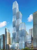
It's not really detailed, but here's a diagram that shows it:
/cdn0.vox-cdn.com/uploads/chorus_asset/file/4390657/IMG_4587.0.jpg)
Taken from this this Curbed article:
http://chicago.curbed.com/2015/10/27...second-meeting.
The first rendering in the article also shows the end of Upper Wacker, if you look carefully:
/cdn3.vox-cdn.com/uploads/chorus_image/image/47866459/IMG_4545-thumb.0.jpg)


 Threaded Mode