HomeDiagramsDatabaseMapsForum About
     

Go Back   SkyscraperPage Forum > Regional Sections > Canada > Alberta & British Columbia > Vancouver > Downtown & City of Vancouver


Reply

 
Thread Tools Display Modes
     
     
  #5861  
Old Posted Mar 17, 2016, 12:56 AM
officedweller officedweller is online now
 
Join Date: Jul 2001
Posts: 41,827
Reply With Quote
     
     
  #5862  
Old Posted Mar 17, 2016, 1:26 AM
BCPhil BCPhil is offline
 
Join Date: Jun 2009
Posts: 2,578
So where is the streetcar supposed to go? Why not make E 1st in that spot the same width as West 1st is with the Median? Is East 1st really going to pinch there compared to the rest of the street?
Reply With Quote
     
     
  #5863  
Old Posted Mar 17, 2016, 1:28 AM
officedweller officedweller is online now
 
Join Date: Jul 2001
Posts: 41,827
I think Building 1 is cut at the corner for streetcar RoW.

But you're right - it's weird that 1st Ave is narrow there.


http://council.vancouver.ca/20050301/p4-f.pdf
Reply With Quote
     
     
  #5864  
Old Posted Mar 17, 2016, 2:24 AM
WarrenC12's Avatar
WarrenC12 WarrenC12 is online now
 
Join Date: May 2007
Posts: 24,743
I've heard the next phase of the Creek will start selling this summer. I don't see why that won't happen given the hot market.
Reply With Quote
     
     
  #5865  
Old Posted Mar 17, 2016, 3:12 AM
mcminsen's Avatar
mcminsen mcminsen is offline
 
Join Date: Sep 2007
Posts: 9,980
Quote:
Originally Posted by officedweller View Post
Thanks.

That's the site of this affordable housing:


Image: Concert Properties
http://www.vancitybuzz.com/2016/03/the-creek-concert-properties-affordable-housing-false-creek/


March 16 '16, my pics


Reply With Quote
     
     
  #5866  
Old Posted Mar 17, 2016, 3:24 AM
mcminsen's Avatar
mcminsen mcminsen is offline
 
Join Date: Sep 2007
Posts: 9,980
Quote:
Originally Posted by officedweller View Post


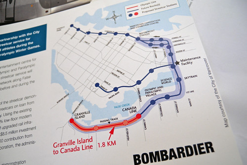
I can't remember the last time I walked this stretch of Quebec Street so I was intrigued to see the old unused streetcar stop. On the diagram above I think it's just below and to the right of Science World.


March 16 '16, my pics


Reply With Quote
     
     
  #5867  
Old Posted Mar 17, 2016, 3:48 AM
officedweller officedweller is online now
 
Join Date: Jul 2001
Posts: 41,827
Yeah, it was used until a few years before the Olympics and before Olympic Village was built.
The tracks used to curve across the excavated parking lot and run on the north side of 1st Ave.
Reply With Quote
     
     
  #5868  
Old Posted Mar 17, 2016, 4:33 AM
urbancanadian urbancanadian is offline
 
Join Date: Aug 2014
Posts: 713
The overall ROW is actually the same I believe. They've just decided to construct separated bikes lanes on each side in place of the median. The bike lanes are a part of the Central Valley Greenway, and are meant to extend from Ontario through to Thornton.

I think this is an odd case where they will have to tear the bike lanes out when the streetcar is actually built, which could take who knows how long (only this block would need to be torn out). Normally I would be nervous that the installation of bike lanes means bad news for the streetcar, but the current CVG route along 1st is actually a "temporary" one, meant to be superceded by a route along Central Street.

I edited the map to show the future separated bike lanes in the area. YELLOW is the portion of the Ontario Bikeway that has been completed - it will be extended south somehow. GREEN is the Seaside Greenway (Seawall) which will be upgraded through the site. BLUE is the Quebec Bikeway which has been planned for a while now. The City installed (cheap/temporary) separated lanes around Union, of which these will be an extension.

RED is the recently approved extension of the CVG, continuing from Thornton Street, that will end at Ontario. PURPLE is the future route of the CVG, which will see a small section built through the development site. The section between Quebec and Main was partially built in conjunction with Onni's Central (south of the McDonalds). My guess is that once it's complete (I think the route is still undetermined), the 1st Avenue route will just become another AAA bikeway.

Reply With Quote
     
     
  #5869  
Old Posted Mar 17, 2016, 4:50 AM
WarrenC12's Avatar
WarrenC12 WarrenC12 is online now
 
Join Date: May 2007
Posts: 24,743
Quote:
Originally Posted by urbancanadian View Post
RED is the recently approved extension of the CVG, continuing from Thornton Street, that will end at Ontario. PURPLE is the future route of the CVG, which will see a small section built through the development site. The section between Quebec and Main was partially built in conjunction with Onni's Central (south of the McDonalds). My guess is that once it's complete (I think the route is still undetermined), the 1st Avenue route will just become another AAA bikeway.
]
Thanks for the picture.

That laneway south of McDonald's is a confusing mess, since there are no real bike routes on either side today. Does that mean there will be a light and intersection at Quebec and Central?

Also on the Main side, how will this connect to the CVG that is still on 1st Ave East of Main?

It seems far easier to just have the CVG continue up first and meet the Ontario bikeway, the way it does today.
Reply With Quote
     
     
  #5870  
Old Posted Mar 17, 2016, 5:20 AM
Pinion Pinion is offline
 
Join Date: Jul 2007
Posts: 5,167
Quote:
Originally Posted by officedweller View Post
Yeah, it was used until a few years before the Olympics and before Olympic Village was built.
The tracks used to curve across the excavated parking lot and run on the north side of 1st Ave.
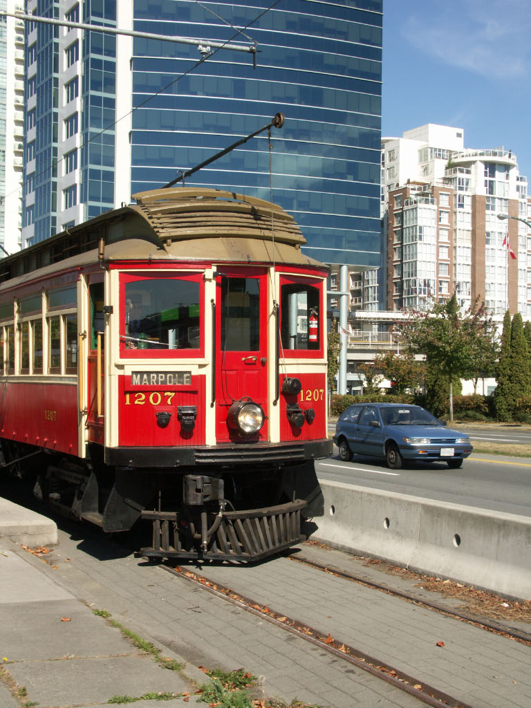
It was used heavily during the olympics/after the village was built (every six minutes) with a modern car, and from 1998 until one year after the olympics with old timey cars on weekends and holidays only.

Reply With Quote
     
     
  #5871  
Old Posted Mar 17, 2016, 6:55 AM
VancouverOfTheFuture's Avatar
VancouverOfTheFuture VancouverOfTheFuture is offline
 
Join Date: Apr 2014
Posts: 3,481
Quote:
Originally Posted by Pinion View Post
It was used heavily during the olympics/after the village was built (every six minutes) with a modern car, and from 1998 until one year after the olympics with old timey cars on weekends and holidays only.
science world station was never used for the Olympic Line Street Car - the modern one. it only went from Granville island - Olympic Village Station at the Canada Line. that is the only part they updated with new tracks.


rebecca bollwitt

this is at science world

wikipedia

if i am correct, i belive the heritage railway stopped going to Science World in 2009, because looking at google street view, the tracks are gone in 2009 but there in 2007.

2007


google chrome

2009


google chrome

Last edited by VancouverOfTheFuture; Mar 17, 2016 at 7:19 AM.
Reply With Quote
     
     
  #5872  
Old Posted Mar 17, 2016, 10:37 AM
officedweller officedweller is online now
 
Join Date: Jul 2001
Posts: 41,827
Thanks for the info.

That's correct WRT the streetcar east of Cambie Bridge.
Once 1st Ave was improved for the Olympic Village, the tracks were ripped out in favour of a future RoW in the middle of the street.
The demonstration project never ran east of Cambie Bridge.

Quote:
Originally Posted by WarrenC12 View Post
Also on the Main side, how will this connect to the CVG that is still on 1st Ave East of Main?
It won't - it'll be continuous east and west of Main St. along Central Street (though I don't see an easy connection east of Main St. to the Emily Carr area).

Quote:
Originally Posted by urbancanadian View Post

... the current CVG route along 1st is actually a "temporary" one, meant to be superceded by a route along Central Street.
Reply With Quote
     
     
  #5873  
Old Posted Mar 17, 2016, 2:10 PM
Metro-One's Avatar
Metro-One Metro-One is online now
 
Join Date: Sep 2008
Posts: 18,038
Quote:
Originally Posted by Pinion View Post
It was used heavily during the olympics/after the village was built (every six minutes) with a modern car, and from 1998 until one year after the olympics with old timey cars on weekends and holidays only.

I remember riding that. I lived in the burbs at the time, was thrilled to take the sky train to Olympic Village, and then take this streetcar to Granville Island (usually I drove when i went there) Fantastic place and the Streetcar really made if feel so much more accessible (I know there is a bus, but this was just so... visible, and enjoyable).

I also remember that Gregor and Vision were super happy to be there for all the photo opps and environmental fanfare about the streetcar.... and slowly killed it very silently... This has always hit me as particularly disingenuous.

For me I still feel with so much of the ROW separated and a good chunk of the infrastructure already in place, running a streetcar from Science World to Granville Island just makes so much sense, a shame it is not being invested on now (a much better use of funds than tearing down the viaducts of the entire CP Arbutus joke IMO)

The only logical excuse I can accept for this is that they are waiting for the M-Line to be extended and have a proper transfer point at Broadway Station with the Canada Line. Otherwise maybe people would have crowded the Streetcar too much from Science World to Olympic Village as a de facto skytrain link between systems?
Reply With Quote
     
     
  #5874  
Old Posted Mar 17, 2016, 3:31 PM
WarrenC12's Avatar
WarrenC12 WarrenC12 is online now
 
Join Date: May 2007
Posts: 24,743
Quote:
Originally Posted by officedweller View Post
It won't - it'll be continuous east and west of Main St. along Central Street (though I don't see an easy connection east of Main St. to the Emily Carr area).
So then it will have to cross Main St. at Central (where there are no lights or control), and even worse, cross train tracks to hook back up to Emily Carr.

Ridiculous.
Reply With Quote
     
     
  #5875  
Old Posted Mar 17, 2016, 3:36 PM
WarrenC12's Avatar
WarrenC12 WarrenC12 is online now
 
Join Date: May 2007
Posts: 24,743
Quote:
Originally Posted by Metro-One View Post
I also remember that Gregor and Vision were super happy to be there for all the photo opps and environmental fanfare about the streetcar.... and slowly killed it very silently... This has always hit me as particularly disingenuous.

For me I still feel with so much of the ROW separated and a good chunk of the infrastructure already in place, running a streetcar from Science World to Granville Island just makes so much sense, a shame it is not being invested on now (a much better use of funds than tearing down the viaducts of the entire CP Arbutus joke IMO)

The only logical excuse I can accept for this is that they are waiting for the M-Line to be extended and have a proper transfer point at Broadway Station with the Canada Line. Otherwise maybe people would have crowded the Streetcar too much from Science World to Olympic Village as a de facto skytrain link between systems?
It was a great project, I rode it a few times. That section in particular from OV station to Granville Island would have been ideal on its own. Transit to Granville Island is crappy at best.

Suzanne Anton gave a last second promise to open the line at a cost of $40M(?) at the 2011 mayoral election. That got my vote, but didn't convince enough people I guess.

For Gregor, I think the Broadway line is their singular focus right now, and I can't find too much fault with that. Translink was also very silent on the streetcar, so I don't know how it would integrate with the rest of the system without their involvement. On it's own, I don't know if it could survive.

If it was a separate fare system, I'd probably consider taking one of the few water taxi services instead to get around False Creek. Although if the streetcar made it all the way to Stanley Park, that would be an option.

I'm happy to see the ROW continue to exist in all official plans. If the massive development around the OV in the last decade can't make the streetcar happen, I don't know what can. Granville Island is set to grow commercially when Emily Carr vacates as well. Hopefully that will make it even more of a destination.

Reply With Quote
     
     
  #5876  
Old Posted Mar 17, 2016, 8:17 PM
officedweller officedweller is online now
 
Join Date: Jul 2001
Posts: 41,827
Quote:
Originally Posted by WarrenC12 View Post
So then it will have to cross Main St. at Central (where there are no lights or control), and even worse, cross train tracks to hook back up to Emily Carr.

Ridiculous.

That's because it's not complete yet.

They'd install lights to cross Main when that part of the route is built.

You're just looking at pieces right now because the developers are building them now (rather than putting money into a fund for future construction?)

I think it may eventually connect to the separated bike lane on Northern Street, since a connection to the Emily Carr area doesn't have a north-south street east of Main Street due to the railway tracks.

It's not shown on this map, from the False Creek Planning materials (May 2015) but that seems to be the most logical connection.


http://vancouver.ca/files/cov/false-creek-flats-launch-event-open-house-information-displays.pdf
Reply With Quote
     
     
  #5877  
Old Posted Mar 17, 2016, 8:52 PM
city-dweller's Avatar
city-dweller city-dweller is offline
 
Join Date: Jul 2008
Posts: 357
Re: CVG
Look at google maps (with "bicycle network on") The Cottrell St to Station Street route is floating only needs a connection at both and ends and your get the connection to the seawall.

Re: Streetcar

The ROW is part of the SEFC area plan and every development next to it has had to not block it. Unless Telus or someone ponies up the money, it will be a decade before they build it. I just hope they separate any tracks from parallel bicycling routes. Perpendicular crossings not an issue can reduce track gap. Parallel = accidents.

Re: Housing

I am guessing building 5 will be last since that is where they built the showroom.

Re: Public Space

The gazebo behind the showroom is slated to go?
Reply With Quote
     
     
  #5878  
Old Posted Mar 17, 2016, 8:56 PM
WarrenC12's Avatar
WarrenC12 WarrenC12 is online now
 
Join Date: May 2007
Posts: 24,743
I know it isn't complete, but they are making a huge problem out of nothing. Why not keep existing routing up 1st ave? There's already a bike/ped only crossing of Main St at first. It's so much simpler than this convoluted plan, and could be easily completed with The Creek development.

Look at the Northern St. orphaned AAA path. It makes no sense. Where is it going further to the east? Over a dozen rail lines?! The path as it exists today along Great Northern way is excellent.

Save the extra crossing of Main St, which will piss off motorists since there's already big lights at Terminal and 2nd Ave, and a controlled crossing at 1st Ave.

They can make Quebec an AAA path if they want, and Ontario is already an established bikeway.
Reply With Quote
     
     
  #5879  
Old Posted Mar 17, 2016, 8:59 PM
WarrenC12's Avatar
WarrenC12 WarrenC12 is online now
 
Join Date: May 2007
Posts: 24,743
Quote:
Originally Posted by city-dweller View Post
Re: CVG
Look at google maps (with "bicycle network on") The Cottrell St to Station Street route is floating only needs a connection at both and ends and your get the connection to the seawall.
You have to know the area. It all looks simple on a map, but if you take the route to Cottrell today it's a complete dead end with no way to get up to Clark without backtracking all the way to get back on Great Northern Way.
Reply With Quote
     
     
  #5880  
Old Posted Mar 17, 2016, 9:04 PM
city-dweller's Avatar
city-dweller city-dweller is offline
 
Join Date: Jul 2008
Posts: 357
My point is there has to be long-term plan.
Reply With Quote
     
     
This discussion thread continues

Use the page links to the lower-right to go to the next page for additional posts
 
 
Reply

Go Back   SkyscraperPage Forum > Regional Sections > Canada > Alberta & British Columbia > Vancouver > Downtown & City of Vancouver
Forum Jump


Forum Jump


All times are GMT. The time now is 7:31 PM.


Powered by vBulletin® Version 3.8.7
Copyright ©2000 - 2026, vBulletin Solutions, Inc.