HomeDiagramsDatabaseMapsForum About
     

Go Back   SkyscraperPage Forum > Photography Forums > Found City Photos

Reply

 
Thread Tools Display Modes
     
     
  #31361  
Old Posted Sep 30, 2015, 5:11 PM
Matt Maxwell Matt Maxwell is offline
Registered User
 
Join Date: May 2015
Posts: 24
Yeah, I was bummed about that picture because it was shot through a bus window. And I didn't get more time to come back to the neighborhood and shoot it properly. But it is great to see the old buildings getting a facelift and not just ripped down.
Reply With Quote
     
     
  #31362  
Old Posted Sep 30, 2015, 5:57 PM
tovangar2 tovangar2 is offline
Registered User
 
Join Date: Nov 2012
Location: West Los Angeles
Posts: 2,625
Hollywood Western Building


Even through a bus window, it's very nice just the same (I actually took it for fog).

- brainy quote

I shamelessly stole your shot for a post I once did on that building. It makes a good update to the Hollywood Western's incredible history.

Thx.
Reply With Quote
     
     
  #31363  
Old Posted Sep 30, 2015, 7:09 PM
HossC's Avatar
HossC HossC is offline
Registered User
 
Join Date: Aug 2013
Posts: 4,245
Julius Shulman only had to move a few blocks north on Pacific Boulevard to photograph this branch of Bank of America. The photoset goes by the title "Job 1030: Bank of America (Huntington Park, Calif.),1951". This time there was definitely a ship on the shield above the entrance (to the left of the flag), but all the large lettering was sans-serif.


Here's a wider view from just north of Randolph Street. The bank building had an impressive roof, and Roberts Furniture had a big roof sign.


The high roof is probably due to the HP (Huntington Park) Ballroom being on the second floor. I love the shop two doors down - an appliance store that modestly calls itself Dorn's House of Miracles.


All from Getty Research Institute

The first floor has been modified, but the bank building survives as a 99 cent store. The buildings across the alley to the north are now a parking lot.


GSV

The bank building retains its high roof and cupola.


GSV

I can't provide color screengrabs as old as e_r's ones of the previous branch, but I can go back to the late '70s. This is another Bank of America that appeared in season 3 of 'CHiPs'. The episode, 'Hot Wheels', centered on a group of criminals who used stolen emergency vehicles to commit robberies, and this bank (redressed for the show) was their first target. Funnily enough, the building with the sunburst on the left of the first image below was a later target. The second image is looking south on Pacific Boulevard from outside the bank, and the third gives the best view I could get of the bank itself. In the last image, the crooks make their escape down the alley next to the bank, which still had buildings on the north side.


MGM TV/Rosner TV
Reply With Quote
     
     
  #31364  
Old Posted Sep 30, 2015, 9:17 PM
Flyingwedge's Avatar
Flyingwedge Flyingwedge is offline
Registered User
 
Join Date: Jun 2012
Location: Los Angeles
Posts: 1,127
Quote:
Originally Posted by tovangar2 View Post
I've seen this photo a number of times:

ucla/islandora depository

Many of the digital libraries seem to agree on the description, "Last Mexican Capital. S Side Plaza. Office of Gov. Pio Pico. The capital of the State of California -(1895)"

(the Bella Union Hotel also claims this honor)


The building shown in the photo above is the building west of the 1884 Plaza fire station, with the brick wall of Pico House (1870) across Sanchez St and the Baker Block (1877-1942) in the distance. I think that is the north wall of the Garnier Building behind. Sostenes Sepulveda's building (now the Chinese American Museum) wasn't built until 1898.

Pio Pico was Mexican governor of Alta California (for the second time) in 1845-46. Was the adobe really that old?

Many of you know a lot more about the Plaza than I ever will, but I thought I'd gather some images of the building through time to try to pin down its age to see if the caption is justified.

Wow that's going to be tough to determine, given the dearth of pre-1850s maps of the plaza area. Perhaps the adobe
is mentioned in a book by an old-timer of the period (e.g., Horace Bell) or in one of the Historical Society of Southern
California articles from the late 1800s or early 1900s.


I think the sign over the door says JAPANESE FANCY GOODS / EMPLOYMENT OFFICE:

HDL -- http://hdl.huntington.org/cdm/single...id/3538/rec/11

Your post mentioned Sanchez Street . . . I discovered I'd saved this:

March 2, 1861 Los Angeles Star @ USCDL -- http://digitallibrary.usc.edu/cdm/re...coll68/id/2096
Reply With Quote
     
     
  #31365  
Old Posted Sep 30, 2015, 9:49 PM
sopas ej's Avatar
sopas ej sopas ej is offline
Registered User
 
Join Date: Jul 2007
Location: South Pasadena, California
Posts: 6,862
I'm loving the Huntington Park photos. I was just there a few weeks ago on Pacific Boulevard. Huntington Park has some really good Mexican restaurants.

Because I can be a streetlight and street furniture freak, I thought I'd post this photo from 1938, of downtown Huntington Park/Pacific Boulevard. Notice the streetlights. These obviously pre-date the style that was installed some time after, I assume during the 1940s, that you can see in HossC's BofA photos. I assume the style of lamps that are there now are kind of a throwback to these older ones, though they obviously don't hit the mark.


LAPL
__________________
"I guess the only time people think about injustice is when it happens to them."

~ Charles Bukowski
Reply With Quote
     
     
  #31366  
Old Posted Sep 30, 2015, 10:18 PM
tovangar2 tovangar2 is offline
Registered User
 
Join Date: Nov 2012
Location: West Los Angeles
Posts: 2,625
Quote:
Originally Posted by Flyingwedge View Post
Your post mentioned Sanchez Street . . . I discovered I'd saved this:

March 2, 1861 Los Angeles Star @ USCDL -- http://digitallibrary.usc.edu/cdm/re...coll68/id/2096
That's interesting that the clipping says Sanchez St will "commence at Aliso" because I've only ever seen it running from Arcadia to the Plaza. Had street names been rearranged between 1861 and 1910?

historicmapworks 1910 plate 3

Last edited by tovangar2; Oct 1, 2015 at 2:24 AM. Reason: larger map
Reply With Quote
     
     
  #31367  
Old Posted Sep 30, 2015, 11:42 PM
srk1941 srk1941 is offline
Registered User
 
Join Date: Aug 2011
Location: Los Angeles
Posts: 67
Those are the only photos I've been able to find online too... I was looking because I'm researching landscape architect Tommy Tomson, and this was one of his projects. It was a high-end Hollywood Regency apartment building, built around a garden court with pool. Red Skelton bought it and owned it for some time... The Maynard Parker collection has, I believe, photographs, but they aren't digitized. I just have to get over to the Huntington to access them... And yes, Ava lived here with Mickey.


Quote:
Originally Posted by ethereal_reality View Post
Here's a pretty rare document:


Ava Gardner's completed questionnaire for employment at MGM.


http://www.royalbooks.com/pages/book...nt-at-mgm-1941


After googling the address Ms. Gardner listed, 10331 Wilshire Boulevard, I was struck by how many famous people have lived at this same address.


-here's a list:


https://books.google.com/books?id=BI...levard&f=false


But the only photographs of 10331 (Wilshire Palms Apartments) I have been able to locate
were from the time Alfred Hitchcock lived there with his wife and young daughter.

below: Here is Mr. Hitchcock looking out over the courtyard of the Wilshire Palms in 1939.


http://www.allposters.com/-sp/Alfred..._i7104617_.htm

I assume the wide street at upper right is Wilshire Boulevard; if that's the case, the street directly in front of Mr. Hitchcock is Comstock Avenue.
(I need some vintage aerials Hoss )


"Film director Alfred Hitchcock, his wife Alma, and their daughter walk their dogs near their apartment at the Wilshire Palms." (also 1939)


http://whataboutbobbed.tumblr.com/po...1/alma-reville

After looking at this for awhile, I believe they're actually within the courtyard of the Wilshire Palms. (not simply near, as stated in the above description)
...if you look closely, the flagpole with cross beam is also visible in the balcony photograph.
__


Lastly, here are the nondescript towers that replaced the Wilshire Palms Apartments.


gsv
__
Reply With Quote
     
     
  #31368  
Old Posted Oct 1, 2015, 5:09 AM
BifRayRock BifRayRock is offline
Registered User
 
Join Date: Apr 2012
Posts: 1,366


Halliburton Luggage


Quote:
Zero Halliburton’s History

The original ‘Halliburton’ aluminum travel cases were hand made for Erle P. Halliburton’s personal use in 1938. A globetrotting oil field engineer by trade, Halliburton was often disappointed with luggage that failed to protect his wardrobe and documents when exposed to the harsh conditions of extreme dirt, heat and dust. Drawing upon the engineering knowledge of his staff, Halliburton guided the development of the world’s first aluminum cases. These unique cases, equipped with smooth sides and an air-tight sealed gasket kept moisture, dirt and dust out. Friends and business associates soon persuaded Halliburton to make additional cases. As a result, a small factory was opened in Southern California. http://zerohalliburton.com/our-heritage

1939 CD Listing > 4059 Goodwin Ave.


1939 Ad

http://digitallibrary.usc.edu/cdm/co...id/72582/rec/2


http://lv-nyc.com/wp-content/uploads...7/IMG_5572.jpg


1946 Ad
Retro reveries


Reply With Quote
     
     
  #31369  
Old Posted Oct 1, 2015, 6:08 AM
BifRayRock BifRayRock is offline
Registered User
 
Join Date: Apr 2012
Posts: 1,366


May 18, 1917 James Jefferies and 'splodin powder. (There were quite a number of James Jeffries' NLA posts discussing his boxing career and saloon keeping business, many of which had images that have evaporated. I don't recall any mention of his venture into explosives.)

http://www.scvhistory.com/gif/sw_for...inel051817.jpg


Jeffries in 1929
http://wesclark.com/burbank/james_jeffries_1929.jpg


Fighter Tom Sharkey, Fmr. Cal. Athletic Commissioner, Everett L. Sanders, Jim Thorpe and James Jeffries. Photo date is in dispute. Probably from '40s.
http://i999.photobucket.com/albums/a...peJeffries.jpg


Jefferies is buried in Inglewood.

http://image2.findagrave.com/photos/...0829298966.jpg

http://image2.findagrave.com/photos/...0829301763.jpg


Fascinating history of explosives manufacturing in the Saugus area> http://www.scvhistory.com/scvhistory/tlp_lat010236.htm


Circa 1935 - Halafax Explosives with factory in Saugus.


http://www.scvhistory.com/gif/tlp_lat042235b.jpg


Reply With Quote
     
     
  #31370  
Old Posted Oct 1, 2015, 1:41 PM
HossC's Avatar
HossC HossC is offline
Registered User
 
Join Date: Aug 2013
Posts: 4,245
Quote:
Originally Posted by CityBoyDoug View Post

Other News: ! ALERT ! - After 9/25/15 9:00PM EST HistoricAerials Map Images will be offline due to upgrades. Thank you for your patience and we be back online soon
They're in the process of adding new cities, etc.
Update: Historic Aerials is still down, but they posted this message yesterday:

Jeff T. on Sep 30 2015 3:47PM

Guys, Thanks for your patience and sorry for the delays and issues. We are testing some software for an "upgrade" and that has led to MANY issues, mostly with compatibility to our previous system. Not to mention some hardware issues coming up during the process. We fix one thing something else happens... that sort of situation. In all honesty we've been working on it since Friday, get something up for a bit and then it's down again. We haven't even been able to start tweaking settings to work on the performance, so currently the new "better" software doesn't seem like much of an improvement. We are aware things seem slow, when they're up. The site will continue to go up and down as we try to correct some of the problems. Even when it is up, certain areas and years may not be populating properly. For instance a tab for a year shows up but you still get a black "we're sorry" screen. As of right now, we're still working and hope to have it more stable in the next couple days (barring anymore setbacks).

Jeff
Reply With Quote
     
     
  #31371  
Old Posted Oct 1, 2015, 2:55 PM
CityBoyDoug CityBoyDoug is offline
BANNED
 
Join Date: Apr 2013
Posts: 2,868
Quote:
Originally Posted by HossC View Post
Update: Historic Aerials is still down, but they posted this message yesterday:

Jeff T. on Sep 30 2015 3:47PM

Guys, Thanks for your patience and sorry for the delays and issues. We are testing some software for an "upgrade" and that has led to MANY issues, mostly with compatibility to our previous system. Not to mention some hardware issues coming up during the process. We fix one thing something else happens... that sort of situation. In all honesty we've been working on it since Friday, get something up for a bit and then it's down again. We haven't even been able to start tweaking settings to work on the performance, so currently the new "better" software doesn't seem like much of an improvement. We are aware things seem slow, when they're up. The site will continue to go up and down as we try to correct some of the problems. Even when it is up, certain areas and years may not be populating properly. For instance a tab for a year shows up but you still get a black "we're sorry" screen. As of right now, we're still working and hope to have it more stable in the next couple days (barring anymore setbacks).

Jeff
Reminds of the old saw...don't try to fix things that aren't broken.
Reply With Quote
     
     
  #31372  
Old Posted Oct 1, 2015, 5:38 PM
HossC's Avatar
HossC HossC is offline
Registered User
 
Join Date: Aug 2013
Posts: 4,245


Like Google Maps!


---------------


Quote:
Originally Posted by BifRayRock View Post

Circa 1935 - Halafax Explosives with factory in Saugus.
Another page at scvhistory.com identifies the location as "just southeast of Bouquet Junction". Amongst the other information is this brief history:
Halafax went bankrupt and was acquired in 1942 by Bermite Powder Co., which was already manfacturing fireworks on adjacent property. Bermite continued to make fireworks and munitions on on its 996-acre property until 1987 when it was forced to shut down (then as a division of Whittaker Corp.), leaving behind dozens of toxic and hazardous materials.
Coincidentally, 1987 was the year that Santa Clarita was incorporated as the union of several previously existing communities, including Canyon Country, Newhall, Saugus, and Valencia. The street names in the area give away their previous use - I spotted Bermite Road, Squib Street, Photoflash Road and Fireworks Road. In the top-left corner is Saugus Speedway which we visited in post #13002 and post #13003 (the pictures are missing from the second post, but it still contains a lot of info). The stadium was a popular filming location in the '80s for shows like 'The Dukes of Hazzard', 'CHiPs' and 'Knight Rider'.


Google Maps

I'm not sure if Jato Road got its name from the factory - to me, JATO stands for "jet-assisted take off", which reminds me of a great urban myth that you can read about at snopes.com.
Reply With Quote
     
     
  #31373  
Old Posted Oct 1, 2015, 8:17 PM
HossC's Avatar
HossC HossC is offline
Registered User
 
Join Date: Aug 2013
Posts: 4,245
Quote:
Originally Posted by ethereal_reality View Post

below: Here is Mr. Hitchcock looking out over the courtyard of the Wilshire Palms in 1939.


http://www.allposters.com/-sp/Alfred..._i7104617_.htm

I assume the wide street at upper right is Wilshire Boulevard; if that's the case, the street directly in front of Mr. Hitchcock is Comstock Avenue.
(I need some vintage aerials Hoss )
I finally managed to get Historic Aerials working long enough to look at this location. The earliest image they have is 1947 (below). I'm assuming Wilshire Palms is the light-colored building in the center, and the trees on Comstock Avenue seem to match those in front of Mr. Hitchcock.


Historic Aerials
Reply With Quote
     
     
  #31374  
Old Posted Oct 1, 2015, 8:25 PM
HossC's Avatar
HossC HossC is offline
Registered User
 
Join Date: Aug 2013
Posts: 4,245
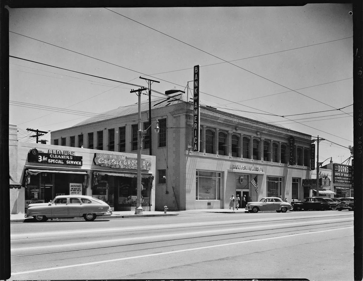
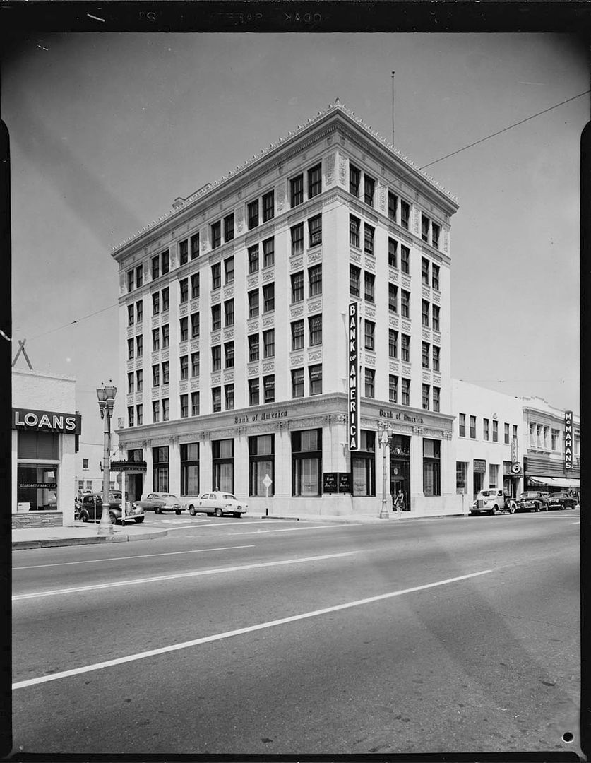
For this Bank of America photoset, Julius Shulman took a trip to the coast (well, a couple of streets away). This is "Job 1005: Bank of America (Santa Monica, Calif.),1951".


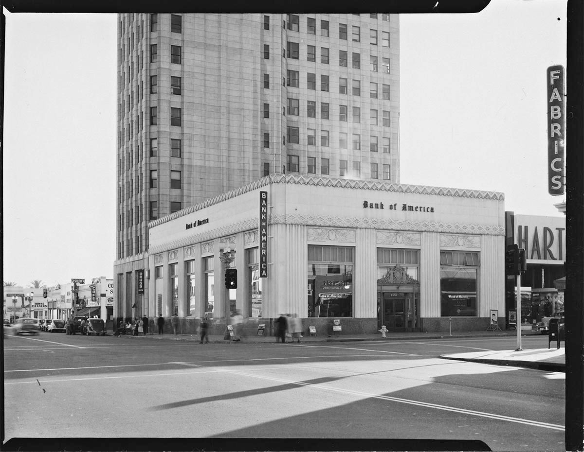
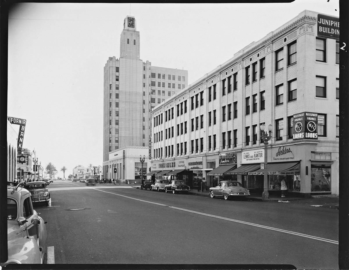
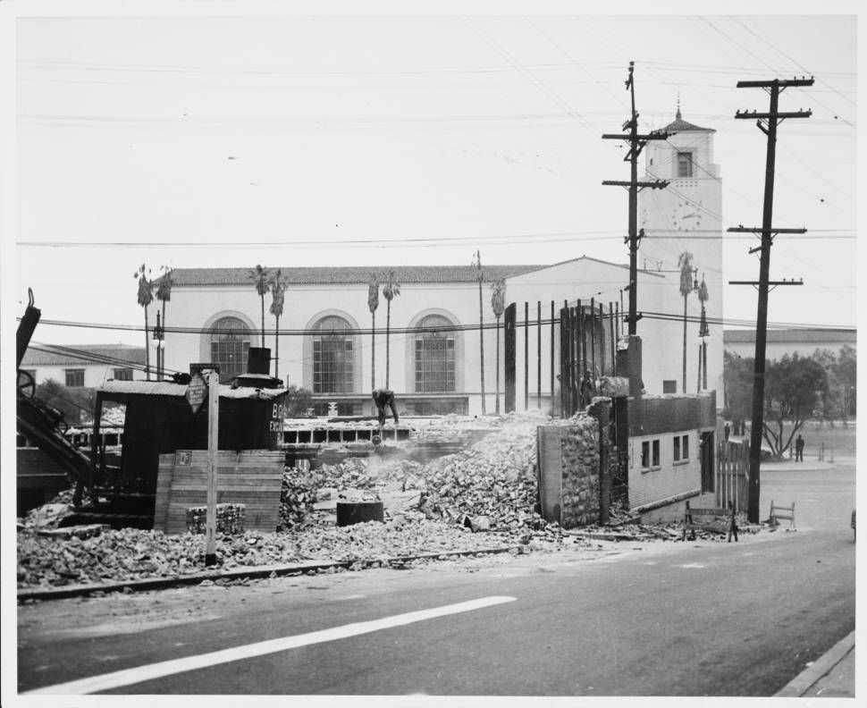
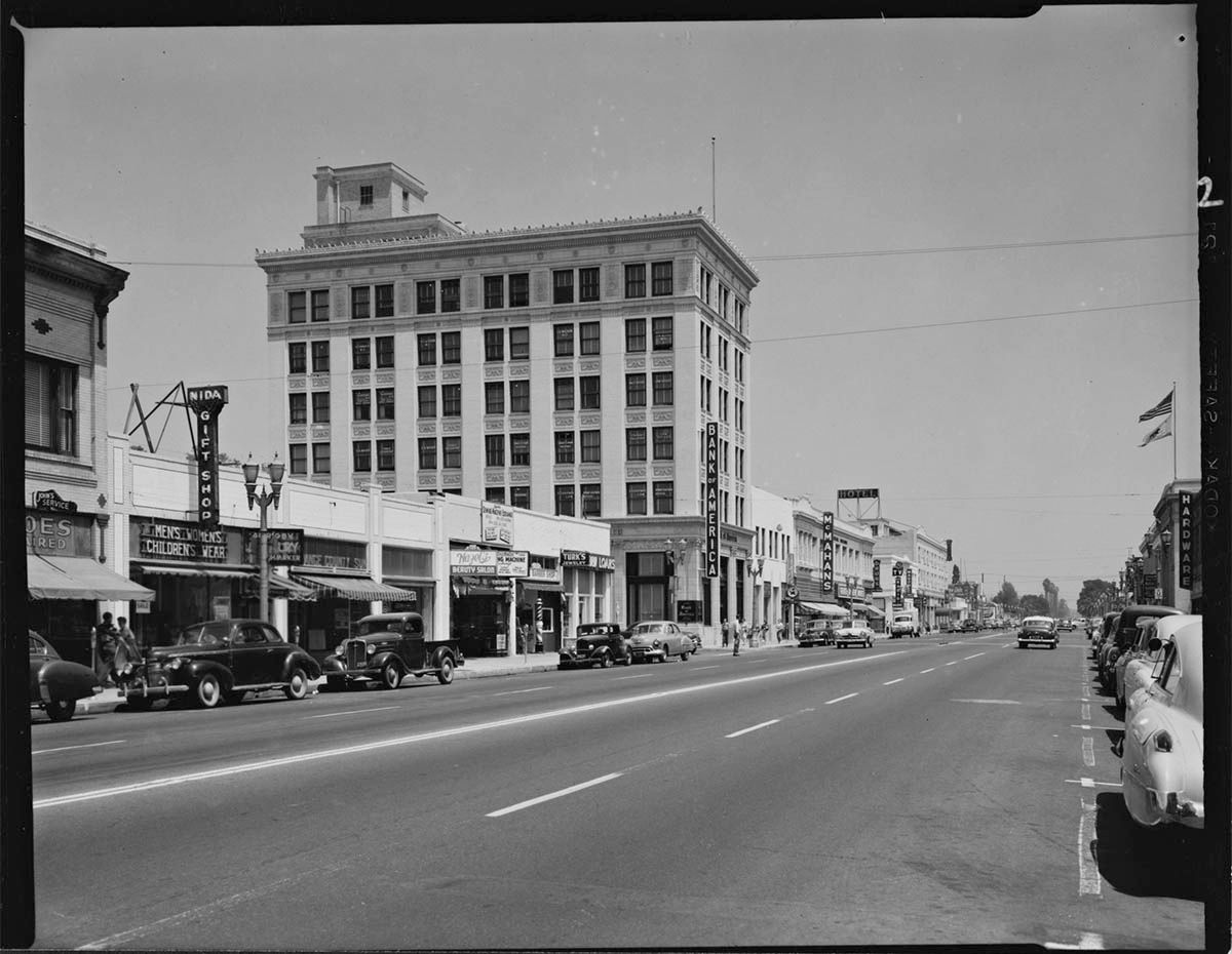
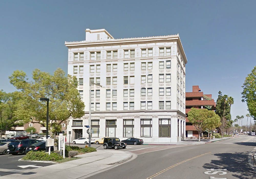
These pictures don't come with locations, and I sometimes worry that there won't be enough clues to find where they were taken. Luckily, the Bay Cities Guaranty Building (aka the Clock Tower Building) places this branch at Santa Monica Boulevard and 3rd Street. On the right is the extant Junipher Building (more on that below).


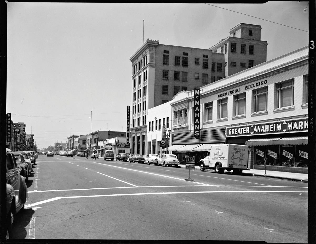
Here's the view looking east.


All from Getty Research Institute

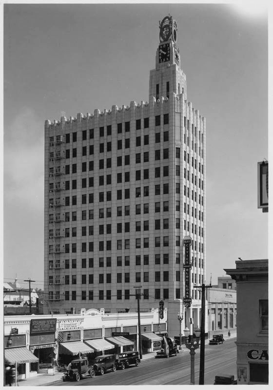
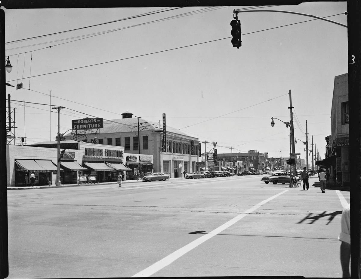
Here's a reminder of a view of the Bay Cities Guaranty Building that we've seen before, complete with large 6s on the clock. This image is dated as "between 1923 and 1933", and also shows the Bank of America building and the cafe from the Shulman photos.


California State Library

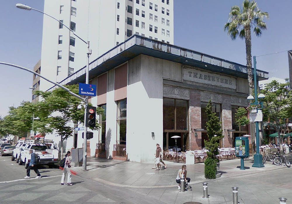
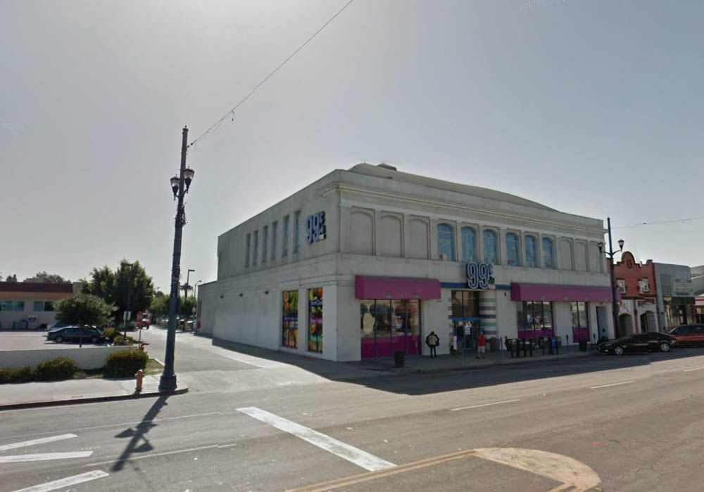
The Bank of America building stood on a site previously occupied by the Dudley Building. We discussed that back in March. ProphetM posted an article about the Dudley building in post #27234, and I posted a current view in post #27231. Just like the Bank of America at 1st and Pine in Long Beach, this one has also become an Italian restaurant. Trastevere has preserved the panels over the windows on the 3rd Street side, but the other details have been lost.


GSV

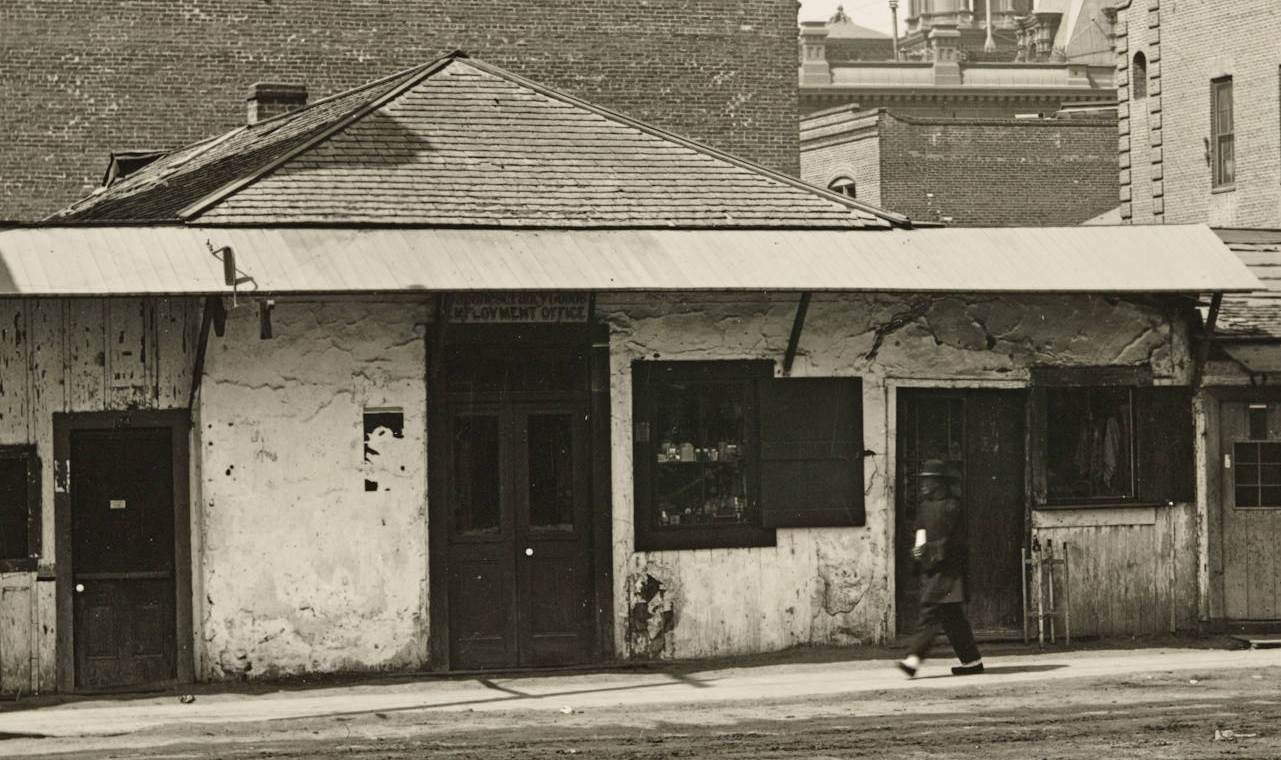
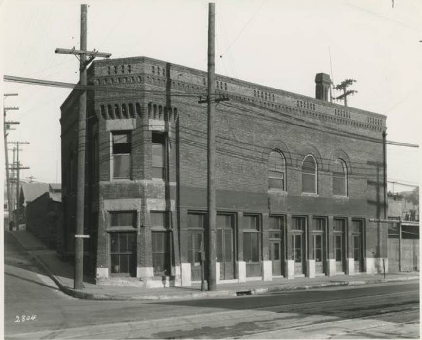
The block with the cafe to the west of the bank has gone, but the Junipher Building is still standing. Google was convinced that I meant "Juniper Building", but the "H" is clearly visbile in the Shulman photo.
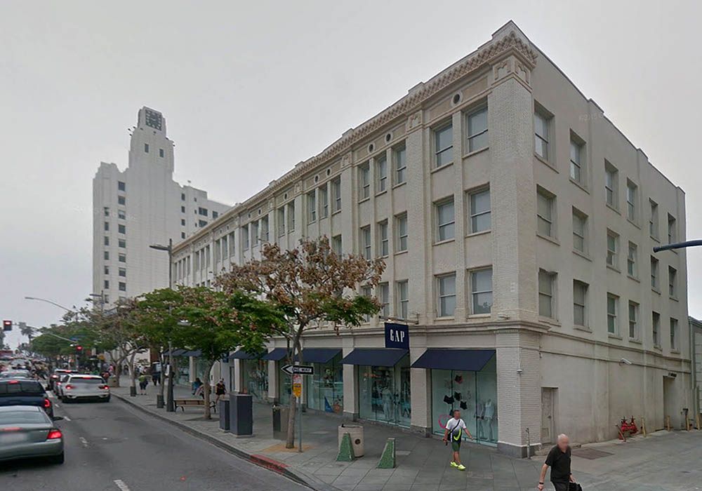

GSV

The quotes below are from a City Landmark Assessment and Evaluation Report about the Junipher Building that I found at santa-monica.org. It's a 52 page PDF file that also contains a load of extra information, newspaper clippings, maps and planning permits. Amusingly, they misspell the building's name as "Juniper" in the very first word of the document!
When initially constructed in 1912, the building was of three stories high and five bays wide along its south (Santa Monica Boulevard) elevation. In 1922, three additional bays were added onto the east (rear) side of the structure. Three years later, a fourth floor was added that modified the original cornice line from one with large decorative brackets set below an extended cornice to the current configuration of an ornate frieze with terra cotta embellishments.
And some background on the Juniphers:
Alexander A. Junipher. Alexander A. Junipher was born in 1827 in Nelsonville, Athens County. He eventually relocated to Hocking County, Ohio where he was a farmer and land owner. He and his wife Julia Bingham Barlett Junipher (1834-1928) were married in 1869 in Ohio. In the later part of the 19th century he was owner of several land holdings and building improvements throughout Hocking County. They had one daughter, Mary Adelaide Junipher (Adelaide Junipher) who was born in 1881 in Ward, Ohio. Junipher’s daughter Adelaide eventually met and married Doctor John S. Hunt with whom she moved to Santa Monica with where he set up and continued his medical practice. Upon selling most of his property in Ohio, A.A. Junipher and his wife Julia moved to Santa Monica in 1904. He was just over 77 years old at that time. They moved in and lived with John and Adelaide Hunt while the Junipher Building was being constructed. Alexander Junipher passed away at his residence at the Hunt’s home on November 22, 1914; only a few years after the building that bears his name was completed. Julia Junipher continued to live with the Hunt family until her passing in 1928. The development and construction of the Junipher Building appears to have been a collaborative investment effort between the Junipher’s and the Hunt family. Besides being an economic investment, the building was probably also constructed as a physical tribute to A.A. Junipher on behalf of John and Adelaide Hunt. Of course it served another role as the office of Hunt’s medical practice.
Reply With Quote
     
     
  #31375  
Old Posted Oct 1, 2015, 9:13 PM
Flyingwedge's Avatar
Flyingwedge Flyingwedge is offline
Registered User
 
Join Date: Jun 2012
Location: Los Angeles
Posts: 1,127
NW corner of Alameda and Marchessault

Quote:
Originally Posted by Flyingwedge View Post

The LA City Water Company building at Alameda and Marchessault, which opened on May 26, 1888 (per 5/27/88 LAT):

USCDL -- http://digitallibrary.usc.edu/cdm/re...coll65/id/5329

Here's that building being torn down in 1939:

USC Digital Library -- http://digitallibrary.usc.edu/cdm/si...d/90010/rec/11
This undated photo, which I've enlarged a bit, looks west across Alameda Street at the old LA City Water Co. building,
which was owned by the city from 1902 on. I don't believe we've seen the front of this building close up before:

UCLA -- http://lit250v.library.ucla.edu/isla.../laviews%3A296
Reply With Quote
     
     
  #31376  
Old Posted Oct 1, 2015, 10:48 PM
tovangar2 tovangar2 is offline
Registered User
 
Join Date: Nov 2012
Location: West Los Angeles
Posts: 2,625


Nice find! Thx
Reply With Quote
     
     
  #31377  
Old Posted Oct 2, 2015, 12:22 AM
CityBoyDoug CityBoyDoug is offline
BANNED
 
Join Date: Apr 2013
Posts: 2,868
Quote:
Originally Posted by CityBoyDoug View Post
I have an odd connection to this motel. My grade school was two blocks north of this location...McKinley School. I somehow visited one of my 6th grade classmates at this motel after school one day. His family had just come from the East coast to buy a mattress business in Los Angeles. Our teacher was very impressed.

They lived in 2 rooms on the right side of this photo. I thought the motel was rather below the tracks.

A few months later the family moved to a large 2 story Spanish style home in the upscale part of Pasadena. It was like a mansion to me. They went from this motel to a mansion.

Its strange and noir how this site can bring your past into the present. .

Here's the location of my old grade school and my friend's temporary motel.


HistoricAerials


Updated: Here's aerial of my old grade school school and the motel from my earlier post. See above.
Reply With Quote
     
     
  #31378  
Old Posted Oct 2, 2015, 6:37 PM
ethereal_reality's Avatar
ethereal_reality ethereal_reality is offline
Registered User
 
Join Date: Feb 2008
Location: Lafayette/West Lafayette IN, Purdue U.
Posts: 16,352
Quote:
Originally Posted by HossC View Post
I finally managed to get Historic Aerials working long enough to look at this location. The earliest image they have is 1947 (below). I'm assuming Wilshire Palms is the light-colored building in the center, and the trees on Comstock Avenue seem to match those in front of Mr. Hitchcock.


Thanks for this Hoss. Now I have an idea of the lay-out of the Wilshire Palms.

At least the vintage building to the west of Wilshire Palms (I've outlined it in red; I hope you don't mind)


here's it is today

google_earth detail

I believe we discussed this enigmatic buildings years ago on this thread, but I don't believe we came up with any further details about it.


gsv


It's on a slight hill. Here's the view of it's plain side from Devon Avenue. Obviously the more ornate side is facing the courtyard on the other side.


gsv

I'd love to know what once stood on this empty lot. (besides Mr. Jingles and His Trees. ) You can vaguely see it in Hoss' vintage aerial.
__
Reply With Quote
     
     
  #31379  
Old Posted Oct 2, 2015, 6:42 PM
HossC's Avatar
HossC HossC is offline
Registered User
 
Join Date: Aug 2013
Posts: 4,245
Julius Shulman's "Job 1043: Bank of America (Anaheim, Calif.),1951" takes us to Anaheim. This branch was on East Center Street.


Here's a longer view looking east.


Looking west, we can see the Greater Anaheim Market and McMahans in the Commercial Building. I think the sign just left of the Commercial Building says "KITKAT".


All from Getty Research Institute

At least one reference I found said that East Center Street was now East Lincoln Avenue. This isn't completely true, but some of it is. Not being able to find the straight road from the Shulman pictures, I went to the 1953 image at Historic Aerials. There's Center Street crossing Anaheim Boulevard as part of a traditional grid layout. Just off to the south and east there were still quite a few blocks of fruit trees.


Historic Aerials

Everything stays much the same up until the 1972 image, but by 1980 (below), big changes are afoot. The previously straight east-west route that was Center Street has been pushed north, and the portion of Center Street around Anaheim Boulevard has either been removed or truncated. Many of the lots along Center Street have been flattened.


Historic Aerials

Here's a current view showing how the re-routed street finished up. A little of East Center Street remains, although pretty much everything in the Shulman photos has been obliterated.


Google Maps

I thought I'd explain the changes to the street layout before revealing that the bank building is still standing.


GSV

The text and picture below are from a description at redfin.com.
This downtown Anaheim landmark, known as the Samuel Kraemer Building, was the first high-rise in Orange County. It is listed on the National Register of Historic Places and is a key element of the Anaheim Colony Historic District. Built in 1924 by rancher and land baron Samuel Kraemer, the building is 33,860 square feet, which features a mix of residential and commercial tenants, with 24,829 square feet of leasable space. It was completely renovated and upgraded in 2003 and has preserved its unique architectural heritage while incorporating modern building and life-safety systems.

www.redfin.com/CRMLS
Reply With Quote
     
     
  #31380  
Old Posted Oct 2, 2015, 6:49 PM
HossC's Avatar
HossC HossC is offline
Registered User
 
Join Date: Aug 2013
Posts: 4,245
Quote:
Originally Posted by ethereal_reality View Post

I believe we discussed this enigmatic buildings years ago on this thread, but I don't believe we came up with any further details about it.


gsv
That's the Chateau Colline. I found some more details and posted them in post #17423.
Reply With Quote
     
     
This discussion thread continues

Use the page links to the lower-right to go to the next page for additional posts

Reply

Go Back   SkyscraperPage Forum > Photography Forums > Found City Photos
Forum Jump


Forum Jump


All times are GMT. The time now is 9:11 AM.

     
SkyscraperPage.com - Archive - Privacy Statement - Top

Powered by vBulletin® Version 3.8.7
Copyright ©2000 - 2024, vBulletin Solutions, Inc.