HomeDiagramsDatabaseMapsForum About
     

Go Back   SkyscraperPage Forum > Regional Sections > Canada > Ontario > Ottawa-Gatineau > Transportation


Reply

 
Thread Tools Display Modes
     
     
  #5921  
Old Posted May 26, 2015, 2:25 PM
McC's Avatar
McC McC is offline
Registered User
 
Join Date: Apr 2010
Posts: 3,057
Somewhat off-topic, but the Province just announced a billion for a shortened LRT line in the Hammer:
http://www.thestar.com/news/gta/transportation/2015/05/26/hamilton-to-get-a-new-lrt.html
Quote:
Hamilton to get a new LRT
Kathleen Wynne announces new LRT route and GO Train expansion in Hamilton
By: Hamilton Spectator Published on Tue May 26 2015

It’s LRT for Hamilton.

Premier Kathleen Wynne got a sustained ovation Tuesday morning in when she announced up to $1 billion to build a light rail line from McMaster University to the Queenston traffic circle, with an eye to eventually reach Eastgate square.

But Transportation Minister Steven Del Duca earned the best response when he stopped to note: “Yeah, I said ‘L’. You heard me say ‘L.’”

The line will connect to the James Street GO Station and a new Centennial GO station in the east city will be built by 2019.

Procurement for the LRT is slated to start in 2017, but construction won’t begin before 2019.

The LRT route is three stops short of the official proposed route to Eastgate Square — or 11 of 14 kilometres — but also represents the part of the corridor with the most “economic uplift” potential, the Spectator reported Tuesday.

More to come.
Reply With Quote
     
     
  #5922  
Old Posted May 26, 2015, 2:38 PM
1overcosc's Avatar
1overcosc 1overcosc is offline
Registered User
 
Join Date: Jun 2013
Location: Eastern Ontario
Posts: 12,377
The province has dragged its feet on that one for almost a decade. Until today nobody really knew if it was happening or not.

This one is a weird case where the City Council doesn't really want it but the province does.
Reply With Quote
     
     
  #5923  
Old Posted May 26, 2015, 3:02 PM
1overcosc's Avatar
1overcosc 1overcosc is offline
Registered User
 
Join Date: Jun 2013
Location: Eastern Ontario
Posts: 12,377
Also on this tangent, the province is doing public consultations on developing a framework to determine allocation of funds for the remaining $11.5B of the non-GTHA portion of the infrastructure fund that has yet to be allocated.

https://www.ontario.ca/form/moving-ontario-forward-share-your-feedback
Reply With Quote
     
     
  #5924  
Old Posted May 26, 2015, 3:06 PM
McC's Avatar
McC McC is offline
Registered User
 
Join Date: Apr 2010
Posts: 3,057
consultations around a framework for implementing a program? where do I sign up!
Reply With Quote
     
     
  #5925  
Old Posted May 26, 2015, 3:10 PM
McC's Avatar
McC McC is offline
Registered User
 
Join Date: Apr 2010
Posts: 3,057
I can't get past Question 2:

Quote:
Do you think about the infrastructure you use on a daily basis? *
o yes
o no
o I don't know
o I prefer not to answer
Do NOT tell Kathleen Wynne what you think about on a daily basis!
Reply With Quote
     
     
  #5926  
Old Posted May 26, 2015, 5:03 PM
rocketphish's Avatar
rocketphish rocketphish is offline
Planet Ottawa and beyond
 
Join Date: Feb 2009
Location: Greater Ottawa
Posts: 14,622
Quote:
Originally Posted by McC View Post
consultations around a framework for implementing a program? where do I sign up!
Isn't that a bit premature? They need to assess the suitability of those consultations vis-a-vis the process of determining the legitimacy of the stakeholders first. Only then can they appraise the value of the potential opinions and determine how to weight the rankings.
Reply With Quote
     
     
  #5927  
Old Posted May 26, 2015, 6:07 PM
MoreTrains MoreTrains is offline
Registered User
 
Join Date: Oct 2014
Posts: 858
Quote:
Originally Posted by McC View Post
I can't get past Question 2:


Do NOT tell Kathleen Wynne what you think about on a daily basis!
'Whatcha thinkin about?'

'Oh you know, infrastrucure I use on a daily basis'

'WTF is wrong with you?'
Reply With Quote
     
     
  #5928  
Old Posted May 30, 2015, 7:25 PM
Richard Eade Richard Eade is offline
Registered User
 
Join Date: Mar 2008
Location: Nepean
Posts: 2,642
I see that there is another Open House (Really, it is an Information Session so any feedback from the public can be ignored.) regarding the western extension of the Transitway - Bayshore to Moodie on June 8, 2015, from 18:30 until 20:30 at the Michele Heights Community Centre, 2955 Michele Drive.
http://ottawa.ca/en/city-hall/planning-a...awa/public-information-session-june-2015

It seems that the folks designing the LRT extension to Bayshore changed things and found ways to make it less expensive to build the busway extension. (They removed the grade separations at Holly Acres and Moodie which the Crystal Beach residents fought so hard to get included and approved. Now when the LRT is extended further west of Bayshore, there will be huge disruptions to the transit and road networks in the area. But it is cheaper now, so who cares about the massive inconvenience and significantly higher cost later, once the ex-Nortel Campus is fully populated by DND employees.)

I find it interesting that City staff can make such drastic changes to a Council approved plan, that was based on a Provincially approved EA.
Reply With Quote
     
     
  #5929  
Old Posted Jun 1, 2015, 8:08 PM
1overcosc's Avatar
1overcosc 1overcosc is offline
Registered User
 
Join Date: Jun 2013
Location: Eastern Ontario
Posts: 12,377
Given that an LRT extension past Bayshore is almost certainly at least 20+ years off, and that there's ample room in the area to provide working areas for future grade separations with minimal disruption (like what's currently being done for the Greenbank-VIA separation for example), I'd say that's not a huge deal.
Reply With Quote
     
     
  #5930  
Old Posted Jun 10, 2015, 1:27 AM
waterloowarrior's Avatar
waterloowarrior waterloowarrior is offline
National Capital Region
 
Join Date: Nov 2005
Location: Eastern Ontario
Posts: 9,254
Quote:
Originally Posted by waterloowarrior View Post
Chapman Mills Extension and Bus Rapid Transit - Environmental Assessment Study
http://ottawa.ca/en/city-hall/public-consultations/transit/open-house-may-7-2015
Notice of Study Commencement and First Open House
Thursday, May 7, 2015
Walter Baker Sports Centre (Barrhaven)
Library Meeting Room (Concourse Level)
100 Malvern Dr, Ottawa, ON K2J 2G5
6:30 to 9 p.m (Presentation: 7 pm)
Transit Access: Route # 170

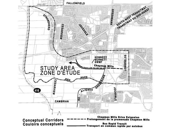
The City of Ottawa has initiated the Chapman Mills Drive Extension (Longfields Drive to Strandherd Drive) and Bus Rapid Transit (Greenbank Road to west of Cedarview Road) Environmental Assessment (EA) Study to determine the most appropriate means to accommodate and manage increasing transportation infrastructure requirements around the Barrhaven Town Centre area.

Study area - Chapman Mills Drive (Longfields Drive to Strandherd Drive) and Bus Rapid Transit (Greenbank Road to west of Cedarview Road).


This first Open House will provide an overview of study progress to-date including:

The evaluation of alternative corridor alignments
An overview of design alternatives which will be considered in the next phase of the study
Display Boards
http://documents.ottawa.ca/sites/documents.ottawa.ca/files/documents/tzs_1_boards_en.pdf
Reply With Quote
     
     
  #5931  
Old Posted Jun 12, 2015, 4:49 PM
rocketphish's Avatar
rocketphish rocketphish is offline
Planet Ottawa and beyond
 
Join Date: Feb 2009
Location: Greater Ottawa
Posts: 14,622
Western Transitway extension moves to level crossings to cut costs

Blair Crawford, Ottawa Citizen
Published on: June 11, 2015, Last Updated: June 11, 2015 9:54 PM EDT


Replacing bridges with level crossings and other modifications to the planned western extension of the Transitway to Moodie Drive will save the city $22 million, says Coun. Keith Egli, chairman of the city’s transportation committee.

The revamped plans for the Transitway extension from Bayshore Mall to Moodie were driven by a drop in the number of commuters expected to take the bus to the new Department of National Defence site on Moodie Drive, Egli said. DND has nearly halved the number of employees it expects to house at the former Nortel campus.

“Initially it was anticipated there would be 15,000 people there and now it’s looking like it will be more like 8,500,” Egli said. “That makes a significant difference in terms of how many people are going to use this, at least in the short term. That was part of the impetus for us going in and saying, ‘Maybe we should look at this again.’ ”

The new plan calls for the Transitway to cross Holly Acres Road at a signal-controlled level intersection, similar to the way the bus route crosses Woodroffe Avenue and Pinecrest Road. “That will be more compact and efficient and more cost effective in terms of the bus-LRT transfer spot,” Egli said.

The Transitway will continue parallel to Highway 417 on the north side of the highway, then enter the 417 at the Moodie Drive interchange. The new plan requires just one bridge, instead of four, and eliminates the need for a stormwater pumping station at Moodie Drive. Sound barriers will reduce the noise for residents along Corkstown Road and in Lakeview Park.

The total savings are in the neighbourhood of $22 million, Egli said.

The revamped plan was presented to the public at an open house this week and is expected to go before the transportation committee on June 30.

If the plan gets the OK from council, and approval from the Ministry of Transportation and the National Capital Commission, work could begin in 2016 with completion in late 2017, Egli said.

[email protected]
Twitter.com/getBAC

http://ottawacitizen.com/news/local-news...on-moves-to-level-crossings-to-cut-costs

Last edited by rocketphish; Jun 12, 2015 at 5:05 PM.
Reply With Quote
     
     
  #5932  
Old Posted Jun 12, 2015, 5:05 PM
lrt's friend lrt's friend is offline
Registered User
 
Join Date: Dec 2006
Posts: 12,792
Are we setting ourselves up that LRT will never be extended beyond Bayshore?
Reply With Quote
     
     
  #5933  
Old Posted Jun 12, 2015, 6:03 PM
1overcosc's Avatar
1overcosc 1overcosc is offline
Registered User
 
Join Date: Jun 2013
Location: Eastern Ontario
Posts: 12,377
Probably not for another 20 years given the finances, although the Kanata extension will probably be the most heavily lobbied-for extension after Phase 2 is complete so who knows.

I don't see having a level crossing at Holly Acres as being a long term detriment to LRT conversion. They could just grade separate it as part of the conversion work.
Reply With Quote
     
     
  #5934  
Old Posted Jun 12, 2015, 6:52 PM
TransitZilla TransitZilla is offline
Registered User
 
Join Date: Dec 2006
Posts: 2,800
Quote:
Originally Posted by rocketphish View Post
The new plan requires just one bridge, instead of four
Anyone know what bridge is remaining? Is it an underpass of Moodie for westbound buses?
Reply With Quote
     
     
  #5935  
Old Posted Jun 12, 2015, 7:08 PM
eternallyme eternallyme is offline
Registered User
 
Join Date: Mar 2009
Posts: 5,243
In the suburbs, I see no reason why level crossings cannot be used due to somewhat lower frequencies. (In the case of Orleans, it just happens the most logical corridor is already grade-separated)

It should be like a metro from Blair to Lincoln Fields though, although pedestrian-only level crossings may be acceptable.
Reply With Quote
     
     
  #5936  
Old Posted Jun 30, 2015, 10:52 PM
rocketphish's Avatar
rocketphish rocketphish is offline
Planet Ottawa and beyond
 
Join Date: Feb 2009
Location: Greater Ottawa
Posts: 14,622
Transitway extension from Bayshore to Moodie approved

Matthew Pearson, Ottawa Citizen
Published on: June 30, 2015 | Last Updated: June 30, 2015 4:30 PM EDT


Despite objections from residents and community associations, the transportation committee has approved the construction of a level crossing at Holly Acres Road as part of the planned western extension of the Transitway to Moodie Drive.

The revamped plans for extending the Transitway from Bayshore Shopping Centre to Moodie were largely driven a drop in the number of commuters expected to take the bus to the new Department of National Defence site on Moodie Drive. DND has nearly halved the number of employees it expects to house at the former Nortel campus, from 15,000 to about 8,500.

Such a significant drop in the number people who might use the new Transitway extension prompted the city to re-examine its plan, creating a savings of $22 million.

The new plan, which council will consider on July 8, calls for the Transitway to cross Holly Acres Road at a signal-controlled level intersection, similar to the way the bus route crosses Woodroffe Avenue and Pinecrest Road.

It will continue parallel to Highway 417 on the north side of the highway, then enter the 417 at the Moodie Drive interchange. The new plan requires just one bridge, instead of four, and eliminates the need for a stormwater pumping station at Moodie Drive.

Changes to the plan were panned by both the Creekside and Crystal Bay/Lakeview community associations.

Creekside’s president Jennifer Smith told the committee she doesn’t believe the rationale for a bridge over Holly Acres Road has changed, despite the lower numbers projected at DND. She’s also worried about increased noise levels and bus traffic, as well as the location of a proposed bus staging area at Bayshore station.

Smith asked the committee to “take a hard second look at our concerns.”

She also pushed for a commitment that sound barriers will be installed to reduce the noise for residents along Corkstown Road and in Lakeview Park.

Ziad Ghadban, who’s overseeing the project, said the city has reached a draft agreement with the Ministry of Transportation that would see barriers installed along the 417 to the east and west of Holly Acres.

Bay Coun. Mark Taylor accepted the plan for an at-grade crossing, but asked staff to explore the possibility of building the bridge as soon as possible, perhaps as part of the phase two expansion of light rail, which the finance committee approved Monday.

“That’s what the community would like to have,” Taylor said.

Such a project may make sense, Taylor added, if Kanata South Coun. Allan Hubley’s request for staff to explore the feasibility of bringing LRT to Kanata before 2031 gathers steam. Hubley’s motion was approved unanimously by the finance committee and will be considered by council on July 8.

If the proposed level crossing gets the OK from council, and approval from the Ministry of Transportation and the National Capital Commission, work could begin this year and be ready for use by late 2017.

[email protected]
twitter.com/mpearson78

http://ottawacitizen.com/news/local-news/transitway-extension-from-bayshore-to-moodie-approved

Reply With Quote
     
     
  #5937  
Old Posted Jul 8, 2015, 11:44 PM
ACmodels's Avatar
ACmodels ACmodels is online now
Registered User
 
Join Date: Nov 2014
Location: NCR
Posts: 123
Coun. Michael Qaqish pursues bus link between south 'burbs

BY JON WILLING, OTTAWA SUN
FIRST POSTED: WEDNESDAY, JULY 08, 2015 03:16 PM EDT | UPDATED: WEDNESDAY, JULY 08, 2015 03:21 PM EDT


The hottest request around council involves getting rapid transit to communities sooner than planned.

Gloucester-South Nepean Coun. Michael Qaqish received all of council's support Wednesday for staff to see if a rapid bus link between Barrhaven town centre and Riverside South can be advanced.

The work should be plugged into the city's next transportation master plan scheduled for 2018.

The city doesn't have money earmarked for a rapid transit connection between Barrhaven and Riverside South. It wouldn't even be considered until after 2031.

Qaqish wants to know if a fast bus service between the two communities is feasible and how high of a priority it should be.

If the city's $3-billion Stage 2 transit plan works out, the Trillium Line train will run to Bowesville Rd. in Riverside South. A Transitway-like bus route from Barrhaven would help south-end commuters access the train.

Council also approved a request from Kanata South Coun. Allan Hubley to investigate the possibility of extending LRT to Kanata sooner than currently anticipated, which is after 2031.

Twitter: @JonathanWilling

http://www.ottawasun.com/2015/07/08/coun-michael-qaqish-pursues-bus-link-between-south-burbs
Reply With Quote
     
     
  #5938  
Old Posted Jul 12, 2015, 5:38 PM
eternallyme eternallyme is offline
Registered User
 
Join Date: Mar 2009
Posts: 5,243
I know there has been some discussion on how to build a rail corridor to the urban east end. My best analysis for the Rideau Street-Montreal Road corridor, section by section, is here (the assumption is that it runs from the Rideau Centre to Blair Station):

1) Rideau west of King Edward

* Road width: 16 m
* ROW: 20 m

Simply put, there is insufficient room here for anything on street. In addition, an on-street corridor would leave challenges at Confederation Square in connecting to the Bank Street corridor, which is often mentioned as a rapid transit potential corridor as well, and would provide an east-south connection. Any route here would need to be underground as no suitable surface corridor exists, and an elevated corridor would be unsightly in the Byward Market. Ideally, the bus lanes could be replaced by wider sidewalks on Rideau Street...

Most likely here, a bored tunnel beneath George Street would be required to avoid later conflicts with the Confederation Line while providing an easy underground transfer. In addition, any tunnel would need to clear the Chateau Laurier and Rideau Canal, then slide directly under Wellington Street (to avoid security issues at Parliament Hill). Due to the staging difficulties, it is probable that the tunnel would need to be bored as far west as Bank/Slater in this phase regardless of any routing farther south. Just west of King Edward, the LRT line can move south a block under Rideau Street as it no longer conflicts with the Confederation Line.

2) Rideau east of King Edward to Wurtemburg

* Road width: 17 m
* ROW: 21 m
* ROW with expropriation: up to 40 m

The ROW remains very constrained east of King Edward, but the properties on the south side of Rideau Street are mostly in poor condition and worthy of demolition, so expropriation is possible here for a wider right of way (with an option of maintaining a narrow corridor for redevelopment). I see three reasonable options here.

Option 1: Continue in bored tunnel. This option would keep the bored tunnel from George Street moving eastward, beneath (or very close to) Rideau Street to the Rideau River. It would be the most expensive but least disruptive option as there would be no changes to the streetscape (although the bus lanes could be removed later and replaced by wider sidewalks/intermittent parking lanes). An underground station would likely be located between Nelson Street and Friel Street serving Sandy Hill.

Option 2: Cut and cover tunnel under Rideau Street. This is a compromise option that would place the LRT line only one level beneath the surface, and likely allows for an overpass of the Rideau River. Costs would likely be lower than the bored tunnel, but disruption would be much greater as Rideau Street would likely be closed east of King Edward for as much as 2-3 years. The station here would likely be in the same location.

Option 3: Surface routing. While the current ROW is insufficient, expropriation of properties on the south side of Rideau Street is possible, which would widen the ROW to at least 30 m (40 m is possible). With the wider ROW, either LRT could be placed in the median of Rideau Street, or shifted to one side or the other (south side would be best IMO). From Besserer to Rideau, the following streets should be closed (except possibly for pedestrians): Friel (need to place a station there), Augusta (short street dead ends) and Wurtemburg (need to set up for the Rideau River crossing as below).

3) Rideau River crossing

* Road width: 15 m
* ROW: 17 m

This largely depends on the option chosen in Section 2. Since no station or turning lanes are required on the bridge, there is sufficient room for 2 lanes of traffic and 2 LRT tracks on the Cummings Bridge. However, the overall logistical setup would be challenging.

If the bored tunnel option is chosen in Section 2, it could dig deeper under the Rideau River to successfully cross the river underground (an expensive option), or rise to the surface near Wurtemburg and cross the Cummings Bridge on the south side (at-grade crossing of Rideau Place). A new bridge through an alignment shift would be difficult due to the elevation changes required in difficult locations.

If either the cut-and-cover tunnel or the surface options are chosen for Section 2, there are again two options here. The first option is to use the existing Cummings Bridge (south side) as above (rising to the surface if necessary near Wurtemburg), or to shift alignment to near the end of Daly Avenue (short tunnel/depressed section near Wurtemburg) and build a pair of bridges (separated by an island) across the Rideau River, and those bridges have the added effect of crossing North River Road as well.

4) North River Road to Notre-Dame Cemetery

* Road width: 14 m
* ROW: 18 m
* ROW with expropriation: 28 m

First of all, three stations would be likely in this section. The first station would be located just east of North River Road, the second station near Marier Street and the third station at the eastern edge just west of St. Laurent Boulevard. The ROW needs to consider that fact.

This is where Montreal Road is at its narrowest, and the ROW is insufficient for any surface alignment without expropriation. Unlike west of the Cummings Bridge, there isn't an ideal side to expropriate to widen the alignment either. The north side has heavy commercial development, while the south side has several large residential developments. That side, one expropriation option is possible - south side to Bradley Avenue, north side beyond Bradley to de l'Eglise (with lane shifting) then south side again. The maximum possible ROW is 28 m. Expropriation should not be allowed for medium or high-density residential or dense commercial areas (unless they are in poor condition).

That means three options again exist. The first option is a surface option , which is also noting the lane shifts, likely on the south side of Montreal Road, with the LRT depressing under the Vanier Parkway and the number of crossings reduced for safety reasons (particularly near the stations) - limited at-grade crossings of side streets would be the result. The cut-and-cover tunnel is also an option directly under Montreal Road, but it would result in great disruption for several years. Finally, a bored tunnel is also possible, which can actually tie in well with any option to the west since a tunnel boring placement area/portal would exist near North River Road.

In cases where the route is at-grade over the Cummings Bridge and moves into a tunnel, it would enter the tunnel just east of North River Road (the land use there is well adapted to redevelopment) after an at-grade station. If the route goes from a bridge, the station there would be elevated. Only a through tunnel would result in an underground station.

5) Notre-Dame Cemetery to Aviation Parkway

* Road width: 27 m
* ROW: 40 m

Different options exist here, which are based more on the routing than the specific alignment. East of St. Laurent, the ROW is more than sufficient for a surface routing maintaining 4 lanes of traffic (although turn lanes may be constrained) and all three options - median, north side and south side - are reasonable. St. Laurent Boulevard and the Aviation Parkway should be grade separated from the LRT (likely through depressing). A surface option would work well here if the LRT remained on Montreal Road, with limited grade crossings. The station would be near the Aviation Parkway, accessible on all quadrants, serving the Montfort Hospital as well.

If development on the CFB Rockcliffe grounds is desirable, an alternative option exists. It requires that the LRT remain in a bored tunnel, however, due to the fact it must clear high-density residential areas on a diagonal routing. From St. Laurent, it would move east-northeast, roughly beneath the Brittany/Quarry intersection (an additional station could be built at Brittany Drive due to the greater spacing), then beneath the Aviation Parkway and the Montfort Hospital (a station could be built for the hospital) before emerging beyond the Montfort.

6) Aviation Parkway to Bathgate Drive

* Road width: 26 m
* ROW: 44 m

If Montreal Road is the chosen corridor, again there is ample surface space for the route, and any combination of median, north side or south side could be chosen. The station should be on the straight section just east of Codd's Road where the geometrics are most suitable. Some road closures may be necessary for safety reasons or to accommodate stations. In order to make the alignment shift to move south to Blair Road, the LRT should either elevate or depress just east of Bathgate Drive, then run along the western edge of the NRC property (at grade) into the next section.

If the Rockcliffe site is chosen, then the Brittany/Montfort tunnel section should end NE of the Montfort Hospital, where the lower elevation can result in a natural tunnel portal. From there, an urban LRT option would be possible depending on the design plan (a partially or fully separated LRT at grade would also be possible), and 1 or 2 stations would service the development. It could either shift onto NRC lands, or run beneath Bathgate Drive (cut and cover for a section) to return southward. In this option, a station would be required either at Bathgate/Montreal (just below ground) or on the western edge of the NRC lands at Montreal Road (at-grade taking advantage of a rising Montreal Road).

7) Bathgate Drive to Blair Station

* Exclusive ROW

This section, unlike the others, would be in an exclusive ROW just east of Bathgate Drive, beneath Ogilvie Road, and through the existing big box areas (either depressed, elevated or at grade) to Blair Station, with no full tunneling required. It is the easiest and cheapest as it can be done mostly at grade even if fully grade separated.

If the route comes from Rockcliffe via Bathgate, it would emerge in a depressed alignment just east of Bathgate, with a station at Den Haag serving La Cite Collegiale. With no other road crossings, the LRT can run at-grade as far as just north of Ogilvie Road, where it would dip into an underpass. From there, it could run any of depressed, at grade or elevated through the existing big box areas (depending on structure plans) to a terminus at Blair Station on a separate platform.

If it comes from Rockcliffe via NRC or from Montreal Road, after moving onto the exclusive ROW east of the towers at Bathgate/Montreal, the LRT would snake along the western edge of the NRC property, mostly at grade but depressing under Den Haag (due to the need for a station there). South of Den Haag, it would be the same as the option via Bathgate.
Reply With Quote
     
     
  #5939  
Old Posted Jul 12, 2015, 9:52 PM
Uhuniau Uhuniau is online now
Registered User
 
Join Date: Jan 2010
Posts: 9,072
Quote:
Originally Posted by eternallyme View Post
Laurier and Rideau Canal, then slide directly under Wellington Street (to avoid security issues at Parliament Hill).
What is this imaginary security issue at Parliament Hill?
Reply With Quote
     
     
  #5940  
Old Posted Jul 12, 2015, 10:11 PM
Uhuniau Uhuniau is online now
Registered User
 
Join Date: Jan 2010
Posts: 9,072
Quote:
Originally Posted by eternallyme View Post
The ROW remains very constrained east of King Edward, but the properties on the south side of Rideau Street are mostly in poor condition and worthy of demolition, so expropriation is possible here for a wider right of way (with an option of maintaining a narrow corridor for redevelopment).
This land is far more valuable, both in cash and in intangibles, as developed land than as a surface transportation corridor.

If you start underground east of Rideau Centre, you pretty well have to stay underground until at least the Rideau River.
Reply With Quote
     
     
This discussion thread continues

Use the page links to the lower-right to go to the next page for additional posts
 
 
Reply

Go Back   SkyscraperPage Forum > Regional Sections > Canada > Ontario > Ottawa-Gatineau > Transportation
Forum Jump


Forum Jump


All times are GMT. The time now is 3:34 PM.


Powered by vBulletin® Version 3.8.7
Copyright ©2000 - 2026, vBulletin Solutions, Inc.