HomeDiagramsDatabaseMapsForum About
     

Go Back   SkyscraperPage Forum > Regional Sections > Canada > Alberta & British Columbia > Vancouver > Transportation & Infrastructure


Reply

 
Thread Tools Display Modes
     
     
  #701  
Old Posted Dec 8, 2014, 2:29 AM
SOSS SOSS is offline
Registered User
 
Join Date: Jan 2014
Posts: 661
I'm surprised this hasn't already happened. The money tied up in tracks is considerable. For example: the CN tracks between Vernon and Kelowna have tentatively been sold to the municipality - conditions need to be met over the next 4 months. The corridor is 47.5 kms and the steel from the tracks is worth as much as $12 million (according to an unnamed former director of Transport Canada telling the local paper).
Reply With Quote
     
     
  #702  
Old Posted Dec 8, 2014, 4:58 AM
Stingray2004's Avatar
Stingray2004 Stingray2004 is offline
Registered User
 
Join Date: Jan 2004
Location: White Rock, BC (Metro Vancouver)
Posts: 3,145
Quote:
Originally Posted by officedweller View Post
Little Campbell River Rail Bridge, South Surrey, successfully replaced:

http://www.thenownewspaper.com/news/corr...l-bridge-successfully-replaced-1.1603168
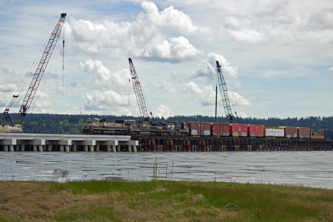
And BNSF continues work on its much, much larger replacement of that long, old timber trestle traversing Mud Bay (adjacent to Hwy 99) with a massive new concrete structure:


Source: railpictures.ca
Reply With Quote
     
     
  #703  
Old Posted Dec 8, 2014, 5:36 AM
Stingray2004's Avatar
Stingray2004 Stingray2004 is offline
Registered User
 
Join Date: Jan 2004
Location: White Rock, BC (Metro Vancouver)
Posts: 3,145
As an afterthought, BNSF must be expending very roughly $50 million for the Mud Bay trestle replacement. If not double that amount.

With that capex, makes one wonder when, and even if, the rerouting of BNSF's ~24 km of track along White Rock/ South Surrey shoreline will take place within the next few decades. If ever.

Reply With Quote
     
     
  #704  
Old Posted Dec 8, 2014, 6:12 AM
SOSS SOSS is offline
Registered User
 
Join Date: Jan 2014
Posts: 661
Quote:
Originally Posted by Stingray2004 View Post
With that capex, makes one wonder when, and even if, the rerouting of BNSF's ~24 km of track along White Rock/ South Surrey shoreline will take place within the next few decades. If ever.
I would imagine it's still highly possible. Especially if an alternative that does not have a tunnel is selected. The sale of the land to Whiterock and Surrey would outweigh the cost of land acquisition and construction. Large challenge: proposed cheapest route runs through amazing agricultural land. With recent track investments I would think in the 15-20 year horizon. Given the right mayors and councils that could be accelerated.
Reply With Quote
     
     
  #705  
Old Posted Dec 8, 2014, 6:57 AM
logicbomb logicbomb is offline
Joshua B.
 
Join Date: Sep 2010
Posts: 1,228
Quote:
Originally Posted by SOSS View Post
I'm surprised this hasn't already happened. The money tied up in tracks is considerable. For example: the CN tracks between Vernon and Kelowna have tentatively been sold to the municipality - conditions need to be met over the next 4 months. The corridor is 47.5 kms and the steel from the tracks is worth as much as $12 million (according to an unnamed former director of Transport Canada telling the local paper).
This was talked about in 2012. SRY ran short-haul trains on this spur which used to service many industries along Beresford and the industrial core near the old the Safeway at Edmonds up until ~1997. With the redevelopment along the spur, there has been recent (very recent) pressure to rid the rails, ties and gravel and build a seamless multipurpose trail between New West and Vancouver. It makes sense. There's no industry along the route and no practical purpose for this line.

It is perplexing that nothing has been mentioned or done over the past 18 years along this old ROW. There has been a lot of rail theft. In fact, what was removed between Metrotown and Patterson station was actually stolen by metal thieves.
Reply With Quote
     
     
  #706  
Old Posted Dec 10, 2014, 11:57 PM
BCPhil BCPhil is offline
Registered User
 
Join Date: Jun 2009
Location: Surrey
Posts: 2,578
Quote:
Originally Posted by Stingray2004 View Post
As an afterthought, BNSF must be expending very roughly $50 million for the Mud Bay trestle replacement. If not double that amount.

With that capex, makes one wonder when, and even if, the rerouting of BNSF's ~24 km of track along White Rock/ South Surrey shoreline will take place within the next few decades. If ever.

From what I've heard, the cost is closer to $10 million to upgrade the trestle, and that might even include a siding along the bridge to help out the Amtrak (I'm not sure about that last part).

Quote:
Originally Posted by SOSS View Post
I would imagine it's still highly possible. Especially if an alternative that does not have a tunnel is selected. The sale of the land to Whiterock and Surrey would outweigh the cost of land acquisition and construction. Large challenge: proposed cheapest route runs through amazing agricultural land. With recent track investments I would think in the 15-20 year horizon. Given the right mayors and councils that could be accelerated.
White Rock estimates the cost of relocating the tracks to be $350-400 million. The land the track is on is currently useless, except maybe 600m that runs through the crescent beach community. The tracks are either behind existing, expensive properties (no way they would let new neighbors be closer to the water) or the track is at the bottom of a cliff (the line was notoriously dangerous to build), or the track is right on the beach through the park. If the line is moved, the only thing they could do with the current ROW is lay down grass. I don't know if it worth buying half a billion dollars of lawn.

So my bet is the land would be a "gift" to the cities if the government were to front the entire $400 million construction cost of moving the tracks.

That much money would be better spent replacing the 110 year old Fraser River rail bridge next to the Pattullo. Not only would it save as much (or more) time for the Amtrak as moving the White Rock tracks, but it would also improve domestic rail capacity (CN, CP, VIA, Amtrak, BNSF and SYR use the bridge) but also improve navigation for ships and barges on the river itself. The bridge is probably the biggest bottle neck to not only more frequent Amtrak service, but also any chance of South of Fraser commuter rail.
Reply With Quote
     
     
  #707  
Old Posted Dec 11, 2014, 12:01 AM
Zassk Zassk is offline
Registered User
 
Join Date: Sep 2009
Posts: 2,303
It is still possible to look on Google Maps and see numerous portions of the old inland rail right-of-way from almost a century ago, winding its way through the agricultural region. Is that land no longer owned by the railway?

Edit - here it is, you can still see the property boundaries and tree lines clearly follow the old track bed:

https://www.google.ca/maps/@49.0245478,-122.7326164,691m/data=!3m1!1e3
https://www.google.ca/maps/@49.0305343,-122.7279818,690m/data=!3m1!1e3
https://www.google.ca/maps/@49.0358761,-122.7167022,688m/data=!3m1!1e3
https://www.google.ca/maps/@49.0410479,-122.7115942,683m/data=!3m1!1e3
https://www.google.ca/maps/@49.0467194,-122.7141381,682m/data=!3m1!1e3
https://www.google.ca/maps/@49.0548213,-122.7277165,691m/data=!3m1!1e3

I lose it north of 32nd Ave, but from there it's just fields and a crossing of the creek to the existing rail corridor.

I wonder who owns this corridor, or if it was all sold off and just happens to remain visible.
Reply With Quote
     
     
  #708  
Old Posted Dec 11, 2014, 1:59 AM
go_leafs_go02 go_leafs_go02 is offline
Registered User
 
Join Date: Dec 2007
Location: London, ON
Posts: 2,406
Quote:
Originally Posted by Zassk View Post
It is still possible to look on Google Maps and see numerous portions of the old inland rail right-of-way from almost a century ago, winding its way through the agricultural region. Is that land no longer owned by the railway?

Edit - here it is, you can still see the property boundaries and tree lines clearly follow the old track bed:

https://www.google.ca/maps/@49.0245478,-122.7326164,691m/data=!3m1!1e3
https://www.google.ca/maps/@49.0305343,-122.7279818,690m/data=!3m1!1e3
https://www.google.ca/maps/@49.0358761,-122.7167022,688m/data=!3m1!1e3
https://www.google.ca/maps/@49.0410479,-122.7115942,683m/data=!3m1!1e3
https://www.google.ca/maps/@49.0467194,-122.7141381,682m/data=!3m1!1e3
https://www.google.ca/maps/@49.0548213,-122.7277165,691m/data=!3m1!1e3

I lose it north of 32nd Ave, but from there it's just fields and a crossing of the creek to the existing rail corridor.

I wonder who owns this corridor, or if it was all sold off and just happens to remain visible.
North of 32 Avenue it followed 176 Street essentially up to Fraser Highway, then Harvie Road north of Fraser Highway to about Highway 1 is the old railway. You can then see through parts of Port Kells how it used to go and then tie into the CN mainline towards Port Mann Bridge.

And alot of the right-of-way is still owned by the City, and is part of their overall greenway (multi-use pathway) network.
Reply With Quote
     
     
  #709  
Old Posted Dec 11, 2014, 3:00 AM
aberdeen5698's Avatar
aberdeen5698 aberdeen5698 is online now
Registered User
 
Join Date: May 2010
Posts: 4,800
Quote:
Originally Posted by BCPhil View Post
That much money would be better spent replacing the 110 year old Fraser River rail bridge next to the Pattullo. Not only would it save as much (or more) time for the Amtrak as moving the White Rock tracks, but it would also improve domestic rail capacity (CN, CP, VIA, Amtrak, BNSF and SYR use the bridge) but also improve navigation for ships and barges on the river itself.
The only thing that is going to improve navigation is if they replace the bridge with a tunnel. There's no way the rail lines in the area can be rebuilt with the kinds of grades needed for a bridge with a clearance like the Patullo or Skybridge. Don't forget that there are no less than two lines that feed into the bridge on the north side and three on the south. Heck, even a tunnel seems unlikely in the current location.
Reply With Quote
     
     
  #710  
Old Posted Dec 11, 2014, 11:14 PM
BCPhil BCPhil is offline
Registered User
 
Join Date: Jun 2009
Location: Surrey
Posts: 2,578
Quote:
Originally Posted by aberdeen5698 View Post
The only thing that is going to improve navigation is if they replace the bridge with a tunnel. There's no way the rail lines in the area can be rebuilt with the kinds of grades needed for a bridge with a clearance like the Patullo or Skybridge. Don't forget that there are no less than two lines that feed into the bridge on the north side and three on the south. Heck, even a tunnel seems unlikely in the current location.
I did say replace, not copy identically but newer. A tunnel would be ideal, hence why I think spending more than the $400 million is needed. Which is why I think it is a waste of so much money and effort to move the track when something else is needed much more urgently.

A bridge is possible though, there is a lot of real estate on both sides for a long run up to keep grades low. And I don't think a bridge would need to be full height. Even just a few meters taller would allow the larger tugs and barges under it and it could be built with a wider draw/lift span to make it safer. And if it were double tracked, more trains could get through while the bridge was down.

I just think it is one of the most underrated and important pieces of infrastructure in Western Canada, and probably THE deciding factor on how many trains we can move through our ports. Even a moderate earthquake will probably sink that bridge. And I can't imagine what would happen to our economy if we were to rely on the Mission bridge as the only way across the river for trains for an extended period of time.
Reply With Quote
     
     
  #711  
Old Posted Dec 15, 2014, 11:25 PM
jlenko jlenko is offline
Registered User
 
Join Date: Nov 2010
Location: Willoughby
Posts: 127
Quote:
Originally Posted by BCPhil View Post
I did say replace, not copy identically but newer. A tunnel would be ideal, hence why I think spending more than the $400 million is needed. Which is why I think it is a waste of so much money and effort to move the track when something else is needed much more urgently.
I don't see that bridge going anywhere anytime soon. CN just spent a 🞵🞵🞵🞵-ton of money upgrading the approaches on the Surrey side from the old timbers to concrete and steel.

Anyone who thinks it's going to be replaced any time soon is dreaming.
Reply With Quote
     
     
  #712  
Old Posted Jan 24, 2015, 1:08 AM
red-paladin red-paladin is offline
Vancouver Moderator
 
Join Date: Sep 2008
Location: Burnaby
Posts: 3,626
Is there enough room in the Grandview Cut for two railway tracks?, if they shift the current track to the side etc? Was that a condition of building the skytrain guideway there?
Reply With Quote
     
     
  #713  
Old Posted Jan 24, 2015, 1:10 AM
officedweller officedweller is offline
Registered User
 
Join Date: Jul 2001
Location: Vancouver
Posts: 41,778
Yes, they left enough room when the M-Line was built.
Reply With Quote
     
     
  #714  
Old Posted Apr 22, 2015, 9:49 PM
twoNeurons twoNeurons is offline
loafing in lotusland
 
Join Date: Aug 2002
Location: Lotusland
Posts: 6,123
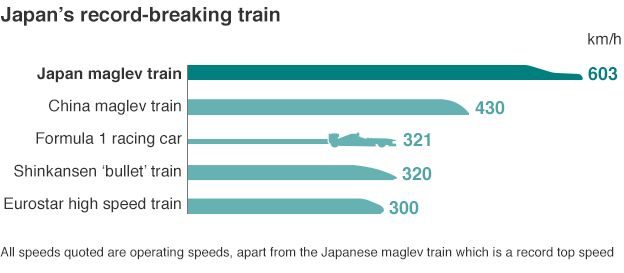
Meanwhile in Japan... they just did a 603km/h test run. I'm surprised they didn't go for 604km/h which would be over 375 mph. Given that Shinzo Abe is trying to get the USA to adopt the technology for its North East Corridor... it's a nicer number in miles... just wait until they reach 643km/h (400mph).

Quote:
The train beat the 590km/h speed it had set last week in another test.
Maglev trains use electrically charged magnets to lift and move carriages above the rail tracks.
Central Japan Railway (JR Central), which owns the trains, wants to introduce the service between Tokyo and the central city of Nagoya by 2027.
The 280km journey would take only about 40 minutes, less than half the current time.

read article.

Imagine a 35 minute ride to Seattle with stops in Bellingham and Everett... or a 65 minute ride to Portland. In case you're wondering, Vancouver–Portland is the identical distance of Tokyo–Osaka. (currently 2:22h by bullet train).

Of course, right now, I'd settle for a 2:30h trip to Seattle.

Has anyone done a speed test of the train along all points north of the border? I'd love to see where the biggest slowdowns North of the border are.
Reply With Quote
     
     
  #715  
Old Posted Apr 22, 2015, 10:10 PM
WarrenC12's Avatar
WarrenC12 WarrenC12 is online now
Registered User
 
Join Date: May 2007
Location: East OV!
Posts: 24,709
The fact that Vancouver-Seattle is slower on a train than a bus is ridiculous.
Reply With Quote
     
     
  #716  
Old Posted Apr 23, 2015, 1:50 AM
twoNeurons twoNeurons is offline
loafing in lotusland
 
Join Date: Aug 2002
Location: Lotusland
Posts: 6,123
Quote:
Originally Posted by WarrenC12 View Post
The fact that Vancouver-Seattle is slower on a train than a bus is ridiculous.
The question is... what would it take to shave 30 minute off the Blaine – Vancouver segment?
Reply With Quote
     
     
  #717  
Old Posted Apr 23, 2015, 3:26 AM
go_leafs_go02 go_leafs_go02 is offline
Registered User
 
Join Date: Dec 2007
Location: London, ON
Posts: 2,406
Quote:
Originally Posted by twoNeurons View Post
The question is... what would it take to shave 30 minute off the Blaine – Vancouver segment?
A new Fraser River bridge or tunnel. A bypass of White Rock/Crescent Beach.
Reply With Quote
     
     
  #718  
Old Posted Apr 23, 2015, 5:14 AM
ClaytonA ClaytonA is offline
Registered User
 
Join Date: Dec 2009
Posts: 601
The BC government continues to maintain they will not fund improvements for passenger rail to Seattle per http://sfb.nathanpachal.com/2015/04/funding-challenges-for-amtrak-cascades.html

Quote:
ODOT and WSDOT met with a BCMoTI representative on several occasions. The representative indicated that no funding is available to help pay for the Amtrak Cascades service in British Columbia. In an effort to control rising costs, Wi-Fi service on the Amtrak Cascades in British Columbia was terminated on Oct. 1, 2014.
Reply With Quote
     
     
  #719  
Old Posted Apr 23, 2015, 5:16 AM
Kisai Kisai is offline
Registered User
 
Join Date: Jun 2014
Location: Burnaby
Posts: 1,154
Quote:
Originally Posted by go_leafs_go02 View Post
A new Fraser River bridge or tunnel. A bypass of White Rock/Crescent Beach.
Three things cause delays for the Amtrak Cascades (and usually one of these is hit with every trip)

1) Fraser River Bridge crossing, also the longest delay
2) It's not double-tracked, so the train has to sit on the siding while freight or the Amtrak Cascades train heading in the other direction passes by
3) Track Hazards. I can't name a single trip that's been absolutely flawless, but consider the geography of BC with rock/landslides, wildlife and high wind/rain and you quickly realize the only way to get "high speed" rail of any sort along the Vancouver-Seattle-Portland is to grade-separate or protect the existing rails with a lot more walls/tunnels.

There's also #4:
Amtrak acts as commuter rail south of the border. So if they cut the commuter stops out on the VAC-SEA-PDX it would also be faster.
Reply With Quote
     
     
  #720  
Old Posted Apr 23, 2015, 5:44 AM
ClaytonA ClaytonA is offline
Registered User
 
Join Date: Dec 2009
Posts: 601
From the WSDOT long range plan available here, pg 100 and map pg 101: http://www.wsdot.wa.gov/Rail/Plans.htm

Within BC in 2006 US $ (millions);
Vancouver Terminal Control System Installation of new traffic control system/$6.9 million
Still Creek to CN Junction New siding/$12.9 million
Sperling-Willingdon Junction Siding New siding/$11.4 million
Willingdon Junction Grade separation/$16 million
Brunette-Piper Siding New siding/$28.6 million
Fraser River Bridge Replace or improve existing bridge/$575 million
Colebrook to Brownsville High-Speed Tracks (north of White Rock)
High speed track, continuation of White Rock bypass/$91.8 million
Colebrook Siding New siding/$11.4 million -----done for 2010 Olympics
White Rock Bypass High speed rail bypass/$312.7 million

Appendix E on pg 209 goes analyzes ending the service in Surrey by building a station by Scott Road and not upgrading anything north of the Fraser. Total is ~1 billion to Pacific Central or $491 million 2006 US dollars just to Scott Road. Due to border security requirements/costs there will probably only ever be one stop north of the 49th parallel. We're spending $3 billion on a new scaled up toll bridge for highway 99 and truck traffic instead.

One could speculate on what a billion dollar George Massey replacement would be and what likely $2 billion spent on rail (plus additional likely from private rail like CN and BNSF) would look like, but it ain't going to happen. Rails are (mostly) privately owned, highways are public owned.

Reply With Quote
     
     
This discussion thread continues

Use the page links to the lower-right to go to the next page for additional posts
 
 
Reply

Go Back   SkyscraperPage Forum > Regional Sections > Canada > Alberta & British Columbia > Vancouver > Transportation & Infrastructure
Forum Jump


Forum Jump


All times are GMT. The time now is 10:46 PM.


Powered by vBulletin® Version 3.8.7
Copyright ©2000 - 2026, vBulletin Solutions, Inc.