HomeDiagramsDatabaseMapsForum About
     

Go Back   SkyscraperPage Forum > Discussion Forums > Buildings & Architecture


    The St. Regis Chicago in the SkyscraperPage Database

Building Data Page   • Comparison Diagram   • Chicago Skyscraper Diagram

Map Location
Chicago Projects & Construction Forum

Reply

 
Thread Tools Display Modes


  #1  
Old Posted Feb 13, 2017, 9:59 PM
danielschell's Avatar
danielschell danielschell is offline
Chicago picture-taker
 
Join Date: Sep 2015
Location: Chicago
Posts: 171
Snapped some photos and a time-lapse of extension work yesterday morning http://wp.me/p7uLxw-2hz

__________________
buildingupchicago.com

Twitter: @buildupchicago

Last edited by danielschell; Feb 13, 2017 at 10:05 PM. Reason: Someone forgot to add a photo
Reply With Quote
     
     
  #2  
Old Posted Feb 14, 2017, 1:18 AM
IrishIllini IrishIllini is offline
Registered User
 
Join Date: Nov 2015
Posts: 1,198
Quote:
Originally Posted by danielschell View Post
Snapped some photos and a time-lapse of extension work yesterday morning http://wp.me/p7uLxw-2hz

Amazing photos, Dan!

Does anyone have a site plan of what Upper Wacker will look like once the extension is completed? Can't find anything from googling.
Reply With Quote
     
     
  #3  
Old Posted Feb 14, 2017, 5:28 PM
Alanky Alanky is offline
Registered User
 
Join Date: Feb 2017
Posts: 11
Sales

The Vista Sales Center informed me that as of this weekend 30% of the units have sold.
Reply With Quote
     
     
  #4  
Old Posted Feb 11, 2017, 8:52 PM
James_Mac's Avatar
James_Mac James_Mac is offline
Registered User
 
Join Date: Apr 2015
Location: Lakeshore East
Posts: 167
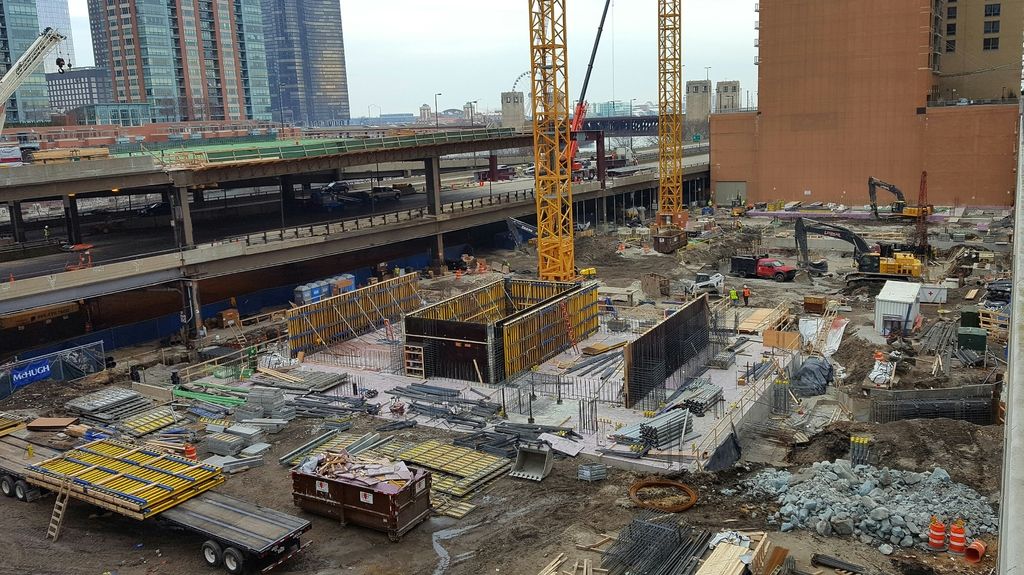
Photo taken around 2:00 today (2/11). It's a bit hard to tell from that angle, but they're actually extending Upper Wacker in the background there - putting up steel beams. All the residential buildings in Lakeshore East got a notice about the ramps being closed this weekend.

EDIT: also, sorry for being dumb, but can someone explain to me exactly how they are connecting Waterside Drive to Upper Wacker? I assume they're extending Waterside Drive north to meet Upper Wacker, but is that happening on the lake side of the Regatta or the other side? Or I am entirely confused??? I can't seem to work it out from the stuff I can find online.

EDIT 2: Nevermind, I worked it out. They're going to extend Waterside Drive behind the Shoreham, so it will continue in a straight line, and then have it turn north and pass through the middle of Vista above where N. Field Blvd. is now to meet Upper Wacker. For some reason I didn't realize they were going to be roads through the middle of Vista at two levels - I thought only the current N. Field Blvd. (soon to be Lower N. Field Blvd, presumably) was actually passing through the building. So they're just extending Upper Wacker so that there's a nice landscaped turnaround area? I'm still a bit confused about that.


Last edited by James_Mac; Feb 11, 2017 at 11:06 PM.
Reply With Quote
     
     
  #5  
Old Posted Feb 12, 2017, 6:45 PM
coldru coldru is offline
Registered User
 
Join Date: Feb 2017
Posts: 12
Vista Tower webcam link.

http://www.vistatowerchicago.com/webcam/

More cameras coming soon
Reply With Quote
     
     
  #6  
Old Posted Feb 12, 2017, 7:04 PM
SteelMonkey SteelMonkey is offline
Registered User
 
Join Date: Feb 2016
Location: Chicago
Posts: 349
Quote:
Originally Posted by coldru View Post
Vista Tower webcam link.

http://www.vistatowerchicago.com/webcam/

More cameras coming soon
NICE!
Reply With Quote
     
     
  #7  
Old Posted Feb 12, 2017, 7:06 PM
KWILLSKYLINE's Avatar
KWILLSKYLINE KWILLSKYLINE is offline
Registered User
 
Join Date: Aug 2016
Location: Chicago
Posts: 625
Quote:
Originally Posted by SteelMonkey View Post
NICE!
Fuck yeah!!.....one bennett,get on it.
Reply With Quote
     
     
  #8  
Old Posted Feb 12, 2017, 8:33 PM
BVictor1's Avatar
BVictor1 BVictor1 is offline
Registered User
 
Join Date: Sep 2002
Location: Chicago
Posts: 10,708
Quote:
Originally Posted by coldru View Post
Vista Tower webcam link.

http://www.vistatowerchicago.com/webcam/

More cameras coming soon
Thanks, and welcome.
__________________
titanic1
Reply With Quote
     
     
  #9  
Old Posted Feb 14, 2017, 8:40 AM
10023's Avatar
10023 10023 is offline
Registered User
 
Join Date: Jun 2007
Location: London
Posts: 21,130
It's always going to dead end isn't it? Or are they going to create an intersection with LSD?
__________________
There is a cult of ignorance in the United States, and there always has been. The strain of anti-intellectualism has been a constant thread winding its way through our political and cultural life, nurtured by the false notion that democracy means that "my ignorance is just as good as your knowledge." - Isaac Asimov
Reply With Quote
     
     
  #10  
Old Posted Feb 14, 2017, 1:35 PM
BVictor1's Avatar
BVictor1 BVictor1 is offline
Registered User
 
Join Date: Sep 2002
Location: Chicago
Posts: 10,708
Quote:
Originally Posted by 10023 View Post
It's always going to dead end isn't it? Or are they going to create an intersection with LSD?
Nope.
__________________
titanic1
Reply With Quote
     
     
  #11  
Old Posted Feb 14, 2017, 1:49 PM
KWILLSKYLINE's Avatar
KWILLSKYLINE KWILLSKYLINE is offline
Registered User
 
Join Date: Aug 2016
Location: Chicago
Posts: 625
Quote:
Originally Posted by BVictor1 View Post
Nope.
Nope to the dead end, or nope to the extension?
Reply With Quote
     
     
  #12  
Old Posted Feb 14, 2017, 1:42 PM
Northwest Northwest is offline
Registered User
 
Join Date: Oct 2007
Location: Chicago
Posts: 413
Quote:
Originally Posted by 10023 View Post
It's always going to dead end isn't it? Or are they going to create an intersection with LSD?
I would guess its only going far enough for a grand entrance to the hotel and residences, and the parking structure. So I guess it would end at the fourth stub of a tower.

This one has to deal with a very wide and expensive three-level street, as well as a street grid extension below the tower. We normally think of streets as a tax funded thing, but is Wanda picking up the entire tab for this? There must be lots of rules associated with air rights over public street right of ways, but I don't recall seeing detailed renderings of where exactly this thing will end.
Reply With Quote
     
     
  #13  
Old Posted Feb 14, 2017, 7:24 PM
James_Mac's Avatar
James_Mac James_Mac is offline
Registered User
 
Join Date: Apr 2015
Location: Lakeshore East
Posts: 167
Quote:
Originally Posted by Northwest View Post
I would guess its only going far enough for a grand entrance to the hotel and residences, and the parking structure. So I guess it would end at the fourth stub of a tower.

This one has to deal with a very wide and expensive three-level street, as well as a street grid extension below the tower. We normally think of streets as a tax funded thing, but is Wanda picking up the entire tab for this? There must be lots of rules associated with air rights over public street right of ways, but I don't recall seeing detailed renderings of where exactly this thing will end.
It's not really detailed, but here's a diagram that shows it:


Taken from this this Curbed article: http://chicago.curbed.com/2015/10/27...second-meeting.

The first rendering in the article also shows the end of Upper Wacker, if you look carefully:

Reply With Quote
     
     
  #14  
Old Posted Feb 14, 2017, 7:51 PM
Northwest Northwest is offline
Registered User
 
Join Date: Oct 2007
Location: Chicago
Posts: 413
^^ Thanks, that explains quite a bit of it from a top view, but still confused as to how Upper Wacker is connected to the LSE Park level road. There must be one hell of a ramp in there somewhere because isn't it like 40 or more vertical feet elevation change?
There not much space there, so where is this steep grade? Under the tower there is a hill?
Reply With Quote
     
     
  #15  
Old Posted Feb 14, 2017, 8:02 PM
LouisVanDerWright LouisVanDerWright is offline
Registered User
 
Join Date: Jul 2012
Posts: 7,451
Quote:
Originally Posted by Northwest View Post
^^ Thanks, that explains quite a bit of it from a top view, but still confused as to how Upper Wacker is connected to the LSE Park level road. There must be one hell of a ramp in there somewhere because isn't it like 40 or more vertical feet elevation change?
There not much space there, so where is this steep grade? Under the tower there is a hill?
It doesn't. There are two levels of roadway passing through Vista, Service Level Wacker at grade and Upper Wacker which will pass through on the top level to connect with the current top level dead end by the Regatta. This means that if you take the top level pass through you will end up popping out over by Harbor Point at the end of Upper Randolph by Cancer Survivors Garden and Maggie Daley Park (which are ironically right next to each other... Too soon?). If you take the Service Level pass through it will spit you out from the River Walk and Impound lot into LSE park.
Reply With Quote
     
     
  #16  
Old Posted Feb 14, 2017, 8:04 PM
James_Mac's Avatar
James_Mac James_Mac is offline
Registered User
 
Join Date: Apr 2015
Location: Lakeshore East
Posts: 167
Quote:
Originally Posted by Northwest View Post
^^ Thanks, that explains quite a bit of it from a top view, but still confused as to how Upper Wacker is connected to the LSE Park level road. There must be one hell of a ramp in there somewhere because isn't it like 40 or more vertical feet elevation change?
There not much space there, so where is this steep grade? Under the tower there is a hill?
The park-level road is N. Field Blvd. It's going to pass under Vista to Sub Lower Wacker, exactly as it does currently, just with a building on top of it. E. Waterside Drive is the elevated road, and it's going to be extended along the north side of the Shoreham (the building south of the east side of Vista) and then turn north and pass through Vista to connect to Upper Wacker. After it turns north it will presumably be renamed Upper N. Field Blvd., or something similar. So roads will pass through Vista at two levels, one on top of the other, with no need for an elevation change for either.

EDIT: Here are slides that show the two levels, taken from the same Curbed article:

1. LOWER LEVEL/PARK LEVEL


2. UPPER LEVEL (E. Waterside Drive / N. Harbor Drive level)

Reply With Quote
     
     
  #17  
Old Posted Feb 14, 2017, 8:19 PM
Northwest Northwest is offline
Registered User
 
Join Date: Oct 2007
Location: Chicago
Posts: 413
Quote:
Originally Posted by the urban politician View Post
^ Its not connected to the park level rd
Quote:
Originally Posted by James_Mac View Post
The park-level road is N. Field Blvd. It's going to pass under Vista to Sub Lower Wacker, exactly as it does currently, just with a building on top of it. E. Waterside Drive is the elevated road, and it's going to be extended along the north side of the Shoreham (the building south of the east side of Vista) and then turn north and pass through Vista to connect to Upper Wacker. After it turns north it will presumably be renamed Upper N. Field Blvd., or something similar. So roads will pass through Vista at two levels, one on top of the other, with no need for an elevation change for either.
Quote:
Originally Posted by James_Mac View Post
It's not really detailed, but here's a diagram that shows it:

^^ Thanks. I get it now. The entire circuit in red here is elevated quite high above park level. Makes sense now! I have only been there a few times, I thought Waterside and Harbor Drive were at park level, but they are elevated streets too. So there are no ramps at all in the final circulation between Upper Randolph and Upper Wacker. It is all at the "upper" level.
Reply With Quote
     
     
  #18  
Old Posted Feb 16, 2017, 6:55 AM
officeworker officeworker is offline
Registered User
 
Join Date: Dec 2016
Posts: 39
2/15


Reply With Quote
     
     
  #19  
Old Posted Feb 14, 2017, 2:29 PM
the urban politician the urban politician is offline
The City
 
Join Date: Jul 2004
Location: Chicago region
Posts: 21,373
It is not a dead end. It connects to the elevated circular drive in Lakeshore East, thus connecting vehicular traffic to Randolph. But it will not be extended to LSD
Reply With Quote
     
     
  #20  
Old Posted Feb 14, 2017, 6:11 PM
the urban politician the urban politician is offline
The City
 
Join Date: Jul 2004
Location: Chicago region
Posts: 21,373
^ Not good
Reply With Quote
     
     
This discussion thread continues

Use the page links to the lower-right to go to the next page for additional posts
 
 
Reply

Go Back   SkyscraperPage Forum > Discussion Forums > Buildings & Architecture
Forum Jump


Forum Jump


All times are GMT. The time now is 5:45 AM.

     
SkyscraperPage.com - Privacy Statement - Top

Powered by vBulletin® Version 3.8.7
Copyright ©2000 - 2026, vBulletin Solutions, Inc.