HomeDiagramsDatabaseMapsForum About
     

Go Back   SkyscraperPage Forum > Discussion Forums > City Discussions


Reply

 
Thread Tools Display Modes
     
     
  #1  
Old Posted May 12, 2014, 10:55 PM
NorthernDancer NorthernDancer is offline
Registered User
 
Join Date: May 2014
Posts: 584
Five square miles greater downtown/inner city population comparison

I was curious how many people lived in a roughly five square mile area of downtown and it's immediate area for selected cities. I tried to get as close to five square mile as possible while:

1. including the entire area that would be referred to by locals as "downtown" (if I'm familiar with the city)

2. trying to get as close to a roughly rectilinear area as possible, while still counting only entire census tracts.

Since the areas are approximate, I've rounded both the areas and the population densities to two significant digits. The numbers are all from the 2010 U.S. Census, and the 2011 Canadian Census.

The Montreal number is far lower than I had anticipated. It's possible I missed some census tracts or miscalculated when I was adding them up.

I was going to add some more cities when I have time. Here are the cities I've done ordered by average density:


1. New York
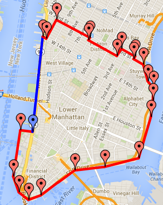


population: 370,430
approx. area: 4.9 square miles
approx. density: 76,000 ppsm


2. Toronto
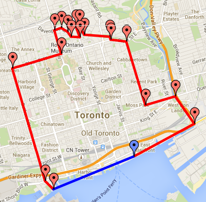


population: 175,064
approx. area: 5.0 square miles
approx. density: 35,000 ppsm


3. Vancouver
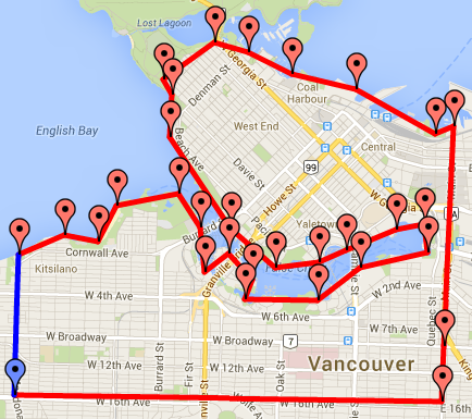


population: 163,753
approx. area: 5.3 square miles
approx. density: 31,000 ppsm


4. San Francisco
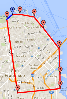


population: 128,317
approx. area: 5.0 square miles
approx. density: 26,000 ppsm


5. Chicago
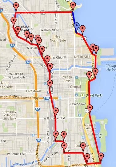


population: 130,308
approx. area: 5.3 square miles
approx. density: 25,000 ppsm


6. Montreal


population: 89,636
approx. area: 4.7 square miles
approx. density: 19,000 ppsm


7. Seattle
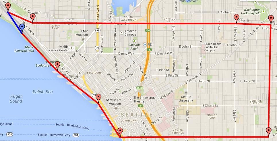


population: 80,438
approx. area: 4.4 square miles
approx. density: 18,000 ppsm

Reply With Quote
     
     
  #2  
Old Posted May 12, 2014, 11:06 PM
Crawford Crawford is online now
Registered User
 
Join Date: Nov 2003
Location: Brooklyn, NYC/Polanco, DF
Posts: 34,743
The five square miles you chose for NYC would not be considered NYC's "downtown" in the U.S. sense of the word (CBD).

I would use a five mile area centering somewhere between 42nd and 57th Streets. That's the business and economic heart of the city.
Reply With Quote
     
     
  #3  
Old Posted May 12, 2014, 11:15 PM
NorthernDancer NorthernDancer is offline
Registered User
 
Join Date: May 2014
Posts: 584
Quote:
Originally Posted by Crawford View Post
The five square miles you chose for NYC would not be considered NYC's "downtown" in the U.S. sense of the word (CBD).

I would use a five mile area centering somewhere between 42nd and 57th Streets. That's the business and economic heart of the city.
I'm planning to do another for Midtown NYC (from 23rd Street north).
Reply With Quote
     
     
  #4  
Old Posted May 12, 2014, 11:22 PM
mhays mhays is online now
Never Dell
 
Join Date: Jul 2001
Posts: 21,072
For Seattle I'd add the two tracts just northwest of this zone (from Downtown proper) and two just south, with densities of 22,363, 13,259, 22,160, and 15,503. Then omit the two on the east, with densities of 10,953 and 9,564. This might get the total to the 20,000/sm range, while getting the land area closer to 5.0. Meanwhile it would be mostly multifamily and commercial rather than a large percentage of houses.

Very interesting analysis btw.
__________________
"Alot" has never been a word.
Reply With Quote
     
     
  #5  
Old Posted May 12, 2014, 11:33 PM
NorthernDancer NorthernDancer is offline
Registered User
 
Join Date: May 2014
Posts: 584
Quote:
Originally Posted by mhays View Post
For Seattle I'd add the two tracts just northwest of this zone (from Downtown proper) and two just south, with densities of 22,363, 13,259, 22,160, and 15,503. Then omit the two on the east, with densities of 10,953 and 9,564. This might get the total to the 20,000/sm range, while getting the land area closer to 5.0. Meanwhile it would be mostly multifamily and commercial rather than a large percentage of houses.

Very interesting analysis btw.
I was trying to keep the areas as close to rectilinear as I could, to make the comparisons as apples-to-apples as possible. With Seattle I was able to get an almost perfectly rectilinear area with the obvious exception of the shoreline. That's why I kept it to roughly 4.4 square miles. There was no obvious way to expand the area and keep it rectilinear while still couting only whole census tracts.
Reply With Quote
     
     
  #6  
Old Posted May 12, 2014, 11:58 PM
dc_denizen's Avatar
dc_denizen dc_denizen is offline
Selfie-stick vendor
 
Join Date: Oct 2005
Location: New York Suburbs
Posts: 10,990
Miami would be interesting.
__________________
Joined the bus on the 33rd seat
By the doo-doo room with the reek replete
Reply With Quote
     
     
  #7  
Old Posted May 13, 2014, 12:58 AM
tech12's Avatar
tech12 tech12 is offline
Registered User
 
Join Date: Sep 2005
Location: Oakland
Posts: 3,330
Cool. The map made for SF includes quite a bit of low-population light industrial stuff in SOMA/Mission Bay/Potrero hill though. If that part was excluded by extending the 5 square mile boundary more westward instead of so far south, the population density would rise.
Reply With Quote
     
     
  #8  
Old Posted May 13, 2014, 1:10 AM
simms3_redux's Avatar
simms3_redux simms3_redux is offline
She needs her space
 
Join Date: Sep 2005
Location: San Francisco
Posts: 2,454
^^^Well the title of the thread does say ~5 square miles. I can't think of any other gerrymandered 5 square miles in SF that would surround downtown.

That being said, using Census Tracts from that NYT sight, I get slightly different results:

125,651 people
4.57 square miles
27,489 ppsm

Eliminating Mission Bay and SOMA one gets 94,574 people in 2.53 square miles for a density of 37,333 ppsm. Eliminating Fisherman's Wharf and South Beach (where AT&T Park is) one gets 79,333 people in 1.59 square miles for a density of 49,934 ppsm. So SF's "downtown" including Nob Hill/Tenderloin/Russian Hill/Civic Center is very very small in area, even if it feels much larger in person.
Reply With Quote
     
     
  #9  
Old Posted May 13, 2014, 2:03 AM
GreaterMontréal's Avatar
GreaterMontréal GreaterMontréal is offline
Registered User
 
Join Date: Dec 2013
Posts: 4,628
600 000 people transit in Dowtown Montréal each day. 320 000+ workers and more than 85 000 students. Downtown Montréal is 16,50km²

Not a huge residential population at night 89k-100k, but during the day, it's bustling with activity. Don't forget that Montréal has a population density of 12,000+/sq mi. Lots of dense neighborhoods close to the downtown core. However, there is a condo boom in the downtown core at the moment, the population will go up in the coming years.
Reply With Quote
     
     
  #10  
Old Posted May 13, 2014, 4:01 AM
DenverInfill's Avatar
DenverInfill DenverInfill is offline
mmmm... infillicious!
 
Join Date: Jan 2004
Location: Lower Highland, Denver
Posts: 3,357
Quote:
Originally Posted by NorthernDancer View Post
I was trying to keep the areas as close to rectilinear as I could, to make the comparisons as apples-to-apples as possible. With Seattle I was able to get an almost perfectly rectilinear area with the obvious exception of the shoreline. That's why I kept it to roughly 4.4 square miles. There was no obvious way to expand the area and keep it rectilinear while still couting only whole census tracts.
Unfortunately, that's the problem with your methodology. Cities don't naturally grow in dense, concentric rectangles around some central point; therefore, many cities are going to have some dense areas missed, or some sparse areas counted due to railyards, bodies of water, big parks, whatever.
__________________
~ Ken

DenverInfill Blog
DenverUrbanism
Reply With Quote
     
     
  #11  
Old Posted May 13, 2014, 5:11 AM
RaymondChandlerLives's Avatar
RaymondChandlerLives RaymondChandlerLives is offline
Registered User
 
Join Date: May 2014
Location: Los Angeles, CA
Posts: 70
For Los Angeles, I started from the Historic Core in DTLA and moved west, passing through the financial district, Westlake, and into Koreatown.

Boundaries: Spring Street to the East, Hollywood Freeway to the North, 8th Street to the South, Normandie Avenue to the West.

5.07 square miles
Population: 163,527
32,254 ppsm


Tracts used
Census Tract 208301
Census Tract 209104
Census Tract 209102
Census Tract 208402
Census Tract 208401
Census Tract 208904
Census Tract 208902
Census Tract 209403
Census Tract 209402
Census Tract 208903
Census Tract 209401
Census Tract 208801
Census Tract 208502
Census Tract 208501
Census Tract 208802
Census Tract 208620
Census Tract 208720
Census Tract 208710
Census Tract 208610
Census Tract 211121
Census Tract 211120
Census Tract 212204
Census Tract 212202
Census Tract 212203
Census Tract 211921
Census Tract 212101
Census Tract 212303
Census Tract 211202
Census Tract 211320
Census Tract 211922
Census Tract 192620
Census Tract 211201
Census Tract 211310
Census Tract 211910
Census Tract 212102
Census Tract 212304
Census Tract 212305
Census Tract 207301
Census Tract 207302
Census Tract 207710
Census Tract 207400
Census Tract 207502
Census Tract 207501
Census Tract 208000
Census Tract 209200
Census Tract 209300
Census Tract 209103
Census Tract 208302
Reply With Quote
     
     
  #12  
Old Posted May 13, 2014, 8:13 AM
tech12's Avatar
tech12 tech12 is offline
Registered User
 
Join Date: Sep 2005
Location: Oakland
Posts: 3,330
I did a new one for San Francisco, using census tracts. The map in the OP included relatively low density parts of mission bay/SOMA/Potero Hill, which includes a lot of light industrial/underdeveloped stuff, so I cut a lot (but not all) of that out, and instead included residential areas just to the west of Van Ness avenue (which is where the map in the OP cut off).

4.9 square miles
171,894 people
35,080 people per square mile


And here's a similar map I did a while ago, but using zip codes:

Reply With Quote
     
     
  #13  
Old Posted May 13, 2014, 2:45 PM
dave8721 dave8721 is offline
Registered User
 
Join Date: Jul 2005
Location: Miami
Posts: 4,186
I did one for Miami using Census Block Groups for a better square. I had to use 77 of them. I included the CBD, Brickell and west into Little Havana. I had to exclude 2 dense areas just to the north and south (Lower Brickell and Edgewater). I Included a little portion of Edgewater because I was low on area. Hopping the bay and including South Beach would have been interesting too.

Area: 4.77 Square Miles
Population: 97,239
Density: 20,360 per square mile.
Reply With Quote
     
     
  #14  
Old Posted May 13, 2014, 4:33 PM
CypressClinton CypressClinton is offline
Registered User
 
Join Date: Feb 2014
Posts: 40
I would love to see Philly, Boston, DC, and Baltimore.
Reply With Quote
     
     
  #15  
Old Posted May 13, 2014, 4:53 PM
emathias emathias is offline
Adoptive Chicagoan
 
Join Date: Sep 2007
Location: River North, Chicago, Illinois
Posts: 5,150
Interesting SF is so interested in gerrymandering but for Chicago's map includes an entirely industrial island in the river, and nearly a full square mile of parkland. You'd definitely see different numbers for Chicago, too, if you dropped Goose Island, Grant Park and the Museum Campus and added in River West, the near West Loop and Chinatown.
Reply With Quote
     
     
  #16  
Old Posted May 13, 2014, 5:06 PM
Steely Dan's Avatar
Steely Dan Steely Dan is online now
devout Pizzatarian
 
Join Date: Jul 2001
Location: Lincoln Square, Chicago
Posts: 30,244
^ yeah, the inclusion of virtually uninhabited goose island, grant park, and the museum campus for "greater downtown chicago" doesn't make this a useful apples-to-apples exercise. that's roughly 1.5 sq. miles of non-residential land included in the 5 sq. mile total, or 30% of the total land area as parkland/industrial no-man's land where zoning makes residential development illegal.

it doesn't make much sense, but whatever, apples-to-apples comparisons of US "downtowns" (in terms of size, population, density, etc.) have been attempted by members of this forum for 15 years now. they all fail.


Quote:
Originally Posted by DenverInfill View Post
Unfortunately, that's the problem with your methodology. Cities don't naturally grow in dense, concentric rectangles around some central point; therefore, many cities are going to have some dense areas missed, or some sparse areas counted due to railyards, bodies of water, big parks, whatever.
+1,000,000
__________________
"Missing middle" housing can be a marvelous middle ground for many middle class families.

Last edited by Steely Dan; May 13, 2014 at 5:30 PM.
Reply With Quote
     
     
  #17  
Old Posted May 13, 2014, 5:18 PM
tech12's Avatar
tech12 tech12 is offline
Registered User
 
Join Date: Sep 2005
Location: Oakland
Posts: 3,330
Quote:
Originally Posted by emathias View Post
Interesting SF is so interested in gerrymandering
How is it "gerrymandering" any more so than the original map is? It's not like there's a "correct" way to measure 5 square miles in a city, and all I did was shift the border slightly so it's not as focused on underdeveloped industrial and port land. Seems reasonable to me.

edit: and for the record, my own map for SF still includes some industrial stuff as well as a bunch of parks (more parkland than the OPs map), it's not like I removed all uninhabited areas from it. The residential areas I added are more connected to downtown than the industrial area I removed anyways.

Last edited by tech12; May 13, 2014 at 5:34 PM.
Reply With Quote
     
     
  #18  
Old Posted May 13, 2014, 5:59 PM
hudkina hudkina is offline
Honored Member
 
Join Date: Nov 2003
Posts: 7,445
There is no definitive way to compare downtowns. Some cities have "downtowns" larger than 5 sq. mi., some cities have "downtowns" much smaller than 5 sq. mi.
Reply With Quote
     
     
  #19  
Old Posted May 13, 2014, 8:16 PM
Chase Unperson's Avatar
Chase Unperson Chase Unperson is offline
Freakbirthed
 
Join Date: Nov 2003
Location: Papa Songs.
Posts: 4,329
How about Paris?
__________________
There are two novels that can change a bookish fourteen-year old's life: The Lord of the Rings and Atlas Shrugged. One is a childish fantasy that often engenders a lifelong obsession with its unbelievable heroes, leading to an emotionally stunted, socially crippled adulthood, unable to deal with the real world. The other, of course, involves orcs
Reply With Quote
     
     
  #20  
Old Posted May 13, 2014, 8:35 PM
killaviews's Avatar
killaviews killaviews is offline
Registered User
 
Join Date: Jul 2006
Location: Chicago
Posts: 492
Looking at the Data on the NYTimes: http://projects.nytimes.com/census/2010/map?ref=us

How come Chicago parks are not separate census tracts? Parks are separate tracts in NYC, SF, Philly.
Reply With Quote
     
     
This discussion thread continues

Use the page links to the lower-right to go to the next page for additional posts
 
 
Reply

Go Back   SkyscraperPage Forum > Discussion Forums > City Discussions
Forum Jump


Forum Jump


All times are GMT. The time now is 7:52 PM.

     
SkyscraperPage.com - Privacy Statement - Top

Powered by vBulletin® Version 3.8.7
Copyright ©2000 - 2026, vBulletin Solutions, Inc.