HomeDiagramsDatabaseMapsForum About
     

Go Back   SkyscraperPage Forum > Regional Sections > Canada


Closed Thread

 
Thread Tools Display Modes
     
     
  #2281  
Old Posted Feb 22, 2014, 4:13 PM
eternallyme eternallyme is offline
Registered User
 
Join Date: Mar 2009
Posts: 5,243
Regarding the Coquihalla, it really should be re-designated as the through Highway 1 route. 5A would become simply 5, while the Fraser Canyon could get a new number (or an extension of 7). The 97-1 multiplex would be simply 97 in that case, while the 1 route through Hope (if 7 is extended) could be something else, or just with trailblazers?
     
     
  #2282  
Old Posted Feb 22, 2014, 4:54 PM
Klazu's Avatar
Klazu Klazu is offline
Registered User
 
Join Date: Apr 2012
Location: Above Metro Vancouver clouds
Posts: 10,394
Quote:
Originally Posted by jeremy_haak View Post
Is the Fraser Canyon route really a lot more scenic? I was driving east from Vancouver once and we took the Coquihalla, and I found it very scenic in its own right, but I'm from Ontario and if you stick any mountain in front of me, I'll be impressed.
Have a look here. Fraser Canyon is much more scenic than Coquihalla.

Talking about Coquihalla, the highway is still completely closed as they try to detonate worst avalanche places. My winter photos on previous page were from two weeks ago, so after those photos over 3 meters of snow has fallen on Coquihalla. That's just crazy!

Driving Coquihalla Highway on summer, one doesn't really understand what all the fuzz is about. It's really one of the most easiest mountain highways to drive and totally uneventful. Not even that scenic, if you ask me.

One really needs to see it during winter time to understand why its a local legend.
     
     
  #2283  
Old Posted Feb 22, 2014, 5:01 PM
Doug's Avatar
Doug Doug is offline
Registered User
 
Join Date: Jul 2001
Posts: 10,046
Quote:
Originally Posted by jeremy_haak View Post
Is the Fraser Canyon route really a lot more scenic? I was driving east from Vancouver once and we took the Coquihalla, and I found it very scenic in its own right, but I'm from Ontario and if you stick any mountain in front of me, I'll be impressed.
It's a different kind of scenic. Rather than going over mountain ranges like the Coquihalla, the TCH is claustrophobic. It puts the driver right in the canyon with curves, tunnels and cliffs. The arid scenery is exotic by Canadian standards. The Fraser Canyon route adds about 2 hours the trip, more if the driver stops at Hell's Gate.
     
     
  #2284  
Old Posted Feb 22, 2014, 5:09 PM
vid's Avatar
vid vid is offline
I am a typical
 
Join Date: Apr 2004
Location: Thunder Bay
Posts: 39,065
Quote:
Originally Posted by Andy6 View Post
Long stretches of the Trans-Canada in eastern Manitoba have as much as a mile between the eastbound and westbound sections. When they built the westbound lanes back in the early 70s, they took a much straighter route rather than following the wandering path of the eastbound lanes that were built in the 1950s. I suppose they thought that the eastbound lanes would eventually be realigned to match the westbound ones, but this has never happened. The result is that Highway 1 from the Ontario boundary to Winnipeg is non-trivially shorter (I don't know by how much) than Highway 1 from Winnipeg to the Ontario boundary.
It's 113km westbound, and 114km eastbound. The widest gap is just west of Highway 308, about 40km west of the boundary. It's pretty nice to drive at night, no on-coming headlights.

Gap on Highway 1/19 in Saskatchewan, 3.9km at its widest point.
     
     
  #2285  
Old Posted Feb 22, 2014, 5:10 PM
Doug's Avatar
Doug Doug is offline
Registered User
 
Join Date: Jul 2001
Posts: 10,046
Quote:
Originally Posted by Klazu View Post
Have a look here
Talking about Coquihalla, the highway is still completely closed as they try to detonate worst avalanche places. My winter photos on previous page were from two weeks ago, so after those photos over 3 meters of snow has fallen on Coquihalla. That's just crazy!

Driving Coquihalla Highway on summer, one doesn't really understand what all the fuzz is about. It's really one of the most easiest mountain highways to drive and totally uneventful. Not even that scenic, if you ask me.

One really needs to see it during winter time to understand why its a local legend.
Canada doesn't have many high altitude roads. The Coq is somewhat unique in that it is an engineered highway that goes over the topography crossing many climactic zones rather than conforming to it. The US has many Coq style highways with much longer grades and more dramatic engineering. I70 climbs from just over 5,000 feet at Denver to over 11,000 feet over about 50 miles. It also has a section cantilevered over Glenwood Canyon. Coquihalla summit is barely over 4,000 feet. Pennask on the Coq Connector is 5,800 feet.
     
     
  #2286  
Old Posted Feb 22, 2014, 5:14 PM
Innsertnamehere's Avatar
Innsertnamehere Innsertnamehere is offline
Registered User
 
Join Date: Jan 2010
Location: Hamilton
Posts: 12,831
US 19 between I-77 and I-79 is also rather interesting. It has the worlds tallest arch bridge IIRC.
     
     
  #2287  
Old Posted Feb 22, 2014, 6:21 PM
1overcosc's Avatar
1overcosc 1overcosc is offline
Registered User
 
Join Date: Jun 2013
Location: Eastern Ontario
Posts: 12,377
The officially posted TCH will probably never be moved away from the old Highway 1 to the Coq. The federal government seems to absolutely abhor changing the TCH route.

There was a similar scenario out east a few decades ago between OTT & MTL. The old TCH east of Ottawa was bypassed by the new 417 freeway in 1975. Yet the old 2 lane route continued to be the TCH. It was only in 1998, when the Ontario government downloaded the old route onto the local governments that the TCH route was finally moved, to avoid the awkwardness of having a local road be the national highway.
     
     
  #2288  
Old Posted Feb 23, 2014, 1:13 AM
MolsonExport's Avatar
MolsonExport MolsonExport is offline
Touching grass everyday.
 
Join Date: Oct 2003
Location: Otisburgh
Posts: 51,069
I got stranded on the Coquihalla a few times during the winter (not a great idea to drive an old Honda Accord during winter....anything can happen, weather-wise; and you need a heavy car to stay on the road during snowstorms). The Okanagan connector can be worse still.
__________________
The whole problem with the world is that fools and fanatics are always so certain of themselves, and wiser people so full of doubts. (Bertrand Russell). Sweet Loretta fart thought she was a cleaner, but she was a frying pan. (John Lennon)
     
     
  #2289  
Old Posted Feb 23, 2014, 1:26 AM
SignalHillHiker's Avatar
SignalHillHiker SignalHillHiker is offline
I ♣ Baby Seals
 
Join Date: Jul 2012
Location: Sin Jaaawnz, Newf'nland
Posts: 36,266
I filmed almost the entire length of the Conception Bay Highway for you guys.

Video Link
__________________
Note to self: "The plural of anecdote is not evidence."
     
     
  #2290  
Old Posted Feb 23, 2014, 2:10 AM
Dmajackson's Avatar
Dmajackson Dmajackson is offline
Moderator
 
Join Date: Feb 2008
Location: B3K Halifax, NS
Posts: 9,916
Quote:
Originally Posted by 1overcosc View Post
The officially posted TCH will probably never be moved away from the old Highway 1 to the Coq. The federal government seems to absolutely abhor changing the TCH route.

There was a similar scenario out east a few decades ago between OTT & MTL. The old TCH east of Ottawa was bypassed by the new 417 freeway in 1975. Yet the old 2 lane route continued to be the TCH. It was only in 1998, when the Ontario government downloaded the old route onto the local governments that the TCH route was finally moved, to avoid the awkwardness of having a local road be the national highway.
You sure that the Fed's don't like changing the highway?

Within my lifetime Route 2 in New Brunswick and Highway 104 in Nova Scotia have had major re-routing done. In NB they moved the highway out of the Saint John River Valley near Woodstock (see my post on the previous page), and in NS they built the infamous Folly Pass over the Cobequid Mountains. I'm not positive about NB but I know that the old TCH in NS is still classified as a "trunk" which is provincially managed and very important for keeping the rural areas alive (similar to Highways 1A and 2A in Alberta).
     
     
  #2291  
Old Posted Feb 23, 2014, 2:15 AM
middeljohn middeljohn is offline
Registered User
 
Join Date: Dec 2012
Location: Burlington, ON
Posts: 1,681
Awesome SHH. That's an interesting portion of the highway where it's one lane each way with no median, but still has on and off ramps. I remember seeing that in Quebec, but the only place in Ontario I've ever seein that is St. Thomas, and it's only for one or two intersections.

On another topic, I just drove highay 25 from Milton to Oakville, and the new twinned section is nice! Hopefully they'll have the whole thing twinned by next year. AADT there must be around 50,000 at least. It's insane that Milton has sprawled from Derry down to Louis Ste Laurent St in less than five years.
     
     
  #2292  
Old Posted Feb 23, 2014, 11:26 AM
SignalHillHiker's Avatar
SignalHillHiker SignalHillHiker is offline
I ♣ Baby Seals
 
Join Date: Jul 2012
Location: Sin Jaaawnz, Newf'nland
Posts: 36,266
Quote:
Originally Posted by middeljohn View Post
Awesome SHH. That's an interesting portion of the highway where it's one lane each way with no median, but still has on and off ramps. I remember seeing that in Quebec, but the only place in Ontario I've ever seein that is St. Thomas, and it's only for one or two intersections.
Yeah, it's unusual for us as well.

That's the farthest portion of the highway from St. John's. It's two lanes each way as far as Manuels, and then one lane each way the rest of the way to Holyrood.

I think it's this way because it really is a rural area out that far, but it has a lot of commuters - so they're sort of halfway between a rural and urban highway (by our standards).
__________________
Note to self: "The plural of anecdote is not evidence."
     
     
  #2293  
Old Posted Mar 2, 2014, 6:31 AM
dmuzika dmuzika is offline
Registered User
 
Join Date: Feb 2006
Posts: 461
Quote:
Originally Posted by eternallyme View Post
Regarding the Coquihalla, it really should be re-designated as the through Highway 1 route. 5A would become simply 5, while the Fraser Canyon could get a new number (or an extension of 7). The 97-1 multiplex would be simply 97 in that case, while the 1 route through Hope (if 7 is extended) could be something else, or just with trailblazers?
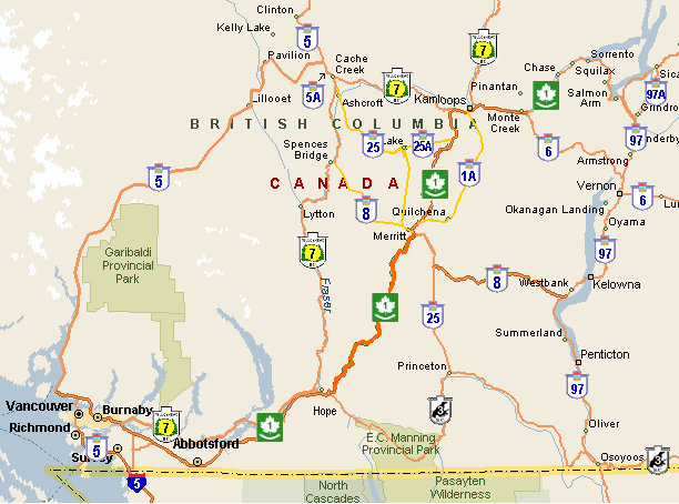
I agree that Trans Canada Hwy should follow the Coquihalla Hwy, I also would argue a that a larger, more comprehensive renumbering of south-western BC’s highways. In addition to TCH 1 following the Coquihalla Highway, I would add that the base premise that:
  1. The that 97C and 97D suffixes would be eliminated.
  2. A continuous highway route number connects the Lower Mainland with northern BC and Prince George.

Here's a reference map on south-western BC:


Renumbering Option 1


  • TCH 1 follows the Coquihalla Hwy
  • Hwy 97C is renumbered as Hwy 8
  • the current TCH 1 (Kamloops-Hope) is renumbered as TCH 1A (maintains TCH for tourist traffic)
  • to create a connection between Vancouver and northern BC, TCH 1 and Hwy 97 become Hwy 7 (cosigned as TCH 1A/Hwy 7 between Hope and Cache Creek)
  • Hwy 97 ends at Salmon Arm (following Hwy 97A & 97B) north of Vernon as little, if any, Alaska bound traffic from the Lower 48 would cross into Canada via the Okanagan

Renumbering Option 2


  • TCH 1 follows the Coquihalla Hwy
  • Hwy 97C is renumbered as Hwy 8
  • Hwy 99 is renumbered as Hwy 5 (continuation of I-5)
  • to create a connection between Vancouver and northern BC, Hwy 97 becomes Hwy 5
  • Yellowhead 5 (YH 5) north of Kamloops and the current TCH 1 (Kamloops-Hope) becomes YH 7 (Hwy 7 between Hope and Vancouver adopts the Yellowhead designation)

Any thoughts?
     
     
  #2294  
Old Posted Mar 5, 2014, 11:39 PM
eemy's Avatar
eemy eemy is offline
Closed account
 
Join Date: Aug 2006
Posts: 4,425
So another major accident has closed a major highway in Ontario for an extended period.

Quote:
Highway 400 southbound lanes reopen after crash near Barrie

A tractor trailer lost control on Highway 400 this morning just south of Barrie, causing a chain of events in which a cube van was pushed through the centre guardrail and into oncoming traffic.

The Ontario Provincial Police say that a southbound tractor trailer was slowing down for a collision in the distance, when it lost control at about 11:30 a.m.

The tractor-trailer rear-ended a cube van, which in turn went through the guardrail. Two other southbound vehicles also ended up being involved in the collision.

The cube van collided with a northbound Honda Civic and minivan.

The female driver of the minivan was taken to hospital with life-threatening injuries.
While the southbound direction now has one lane open, they don't expect he northbound direction will be open until around 10pm.

This section of highway has an AADT of 94,500 as of 2010. While we can't know if a tall-wall barrier would have prevented the cube van from being pushed into the on-coming lanes, the guardrail that was there was certainly not up to the task. It's frankly astonishing that such a busy section of highway is not built to better standards.
     
     
  #2295  
Old Posted Mar 6, 2014, 12:14 AM
waterloowarrior's Avatar
waterloowarrior waterloowarrior is offline
National Capital Region
 
Join Date: Nov 2005
Location: Eastern Ontario
Posts: 9,254
Quote:
Originally Posted by jeremy_haak View Post
So another major accident has closed a major highway in Ontario for an extended period.

While the southbound direction now has one lane open, they don't expect he northbound direction will be open until around 10pm.

This section of highway has an AADT of 94,500 as of 2010. While we can't know if a tall-wall barrier would have prevented the cube van from being pushed into the on-coming lanes, the guardrail that was there was certainly not up to the task. It's frankly astonishing that such a busy section of highway is not built to better standards.
This is underway. Construction started on 400 in Oct 2013 for pavement rehabilitation and replacement of the median between Canal Road and Innisfil Beach Road. Completion in late 2016. $40+ million project.
http://www.thebarrieexaminer.com/2013/09...-barrie-not-part-of-highway-400-roadwork

Innisfil Beach Rd to Essa Rd is planned for 2015-2017 according to the Southern Ontario Highways program

http://www.mto.gov.on.ca/english/pubs/hi...ighway-2013/southern-highway-en-2013.pdf
     
     
  #2296  
Old Posted Mar 6, 2014, 1:25 AM
Innsertnamehere's Avatar
Innsertnamehere Innsertnamehere is offline
Registered User
 
Join Date: Jan 2010
Location: Hamilton
Posts: 12,831
yup, now if they can get rid of the canal road at grade intersection.
     
     
  #2297  
Old Posted Mar 8, 2014, 2:27 AM
libtard's Avatar
libtard libtard is offline
Dahvie Fan
 
Join Date: Aug 2012
Posts: 1,307
Quote:
Southwest ring road gets $1.8B; building may start next year

After decades of negotiations and sputtering hopes and then finally a land deal last fall, crews will begin constructing part of the southwest ring road as soon as next year, with $1.8 billion now budgeted for the project.

http://www.calgaryherald.com/news/politi...lding+start+next+year/9588214/story.html


Its finally happening Will this give Calgary a complete ring road?
     
     
  #2298  
Old Posted Mar 8, 2014, 2:59 AM
Innsertnamehere's Avatar
Innsertnamehere Innsertnamehere is offline
Registered User
 
Join Date: Jan 2010
Location: Hamilton
Posts: 12,831
anywhere I can see plans for it? I.E. its routing?
     
     
  #2299  
Old Posted Mar 8, 2014, 7:56 PM
CanadianCentaur's Avatar
CanadianCentaur CanadianCentaur is offline
Briareos Hecatonchires
 
Join Date: Aug 2002
Location: The Big E
Posts: 3,805
Quote:
Originally Posted by MolsonExport View Post
I got stranded on the Coquihalla a few times during the winter (not a great idea to drive an old Honda Accord during winter....anything can happen, weather-wise; and you need a heavy car to stay on the road during snowstorms). The Okanagan connector can be worse still.
Last Christmas, my relatives and I took the Coq, then Hwy 97C to Kelowna and went north from there to Silver Star. We used my brother's 2005 Honda CRV SUV to get there - it does well, esp. with all-season tires in bad winter weather. The weather was quite wet in Vancouver and the Lower Mainland, but this quickly turned to heavy wet snow by the time we went past Hope. The snow stopped as we got closer to Merritt (it was snow-free there, actually), but Hwy 97C was treacherously icy, and we couldn't go any faster than 60-70 km/h. In fact, my sister in law counted at least 9 vehicles in the ditches. That's right, 9. And quite a few had been flipped over on the side.

The rest of the way from Westbank to Vernon was way better, except for whiteout conditions near the ski resort. The return trip was also far better, with next to no ice on the Hwy 97C connector and no rain/snow all the way back to Vancouver.

__________________
Edmonton/Amiskwacîwâskahikan Lat. 53° 34'N Elevation 671 m (2201 ft) Pop. 1,010,899 (2021 city) 1,418,118 (2021 metro) - North America's northernmost metro area over one million.
     
     
  #2300  
Old Posted Mar 8, 2014, 8:06 PM
dmuzika dmuzika is offline
Registered User
 
Join Date: Feb 2006
Posts: 461
Quote:
Originally Posted by Innsertnamehere View Post
anywhere I can see plans for it? I.E. its routing?
West Ring Road
While not part of the infamous SW Ring Road, the west portion was delayed until the SW Ring Road was finalized. The rough alingment is the existing TCH/Stoney Trail interchange to Glenmore Trail (Hwy 8).

Hwy 8 (Glenmore Trail) to Bow Trail
Bow Trail to TCH 1 (16 Avenue NW) - ties into existing Stoney Trail


South West Ring Road

The ring road continue along an upgraded Hwy 8 from the West Ring Road to the existing Glenmore Trail/Sarcee Trail intersection before turning south.

69 Street SW to Fish Creek
Fish Creek to 162 Avenue SW

The ring road would then continue east along Hwy 22X towards Macleod Trail (Hwy 2A) and the recently completed SE Ring Road.
     
     
This discussion thread continues

Use the page links to the lower-right to go to the next page for additional posts
 
 
Closed Thread

Go Back   SkyscraperPage Forum > Regional Sections > Canada
Forum Jump


Forum Jump


All times are GMT. The time now is 8:47 AM.

     
SkyscraperPage.com - Privacy Statement - Top

Powered by vBulletin® Version 3.8.7
Copyright ©2000 - 2026, vBulletin Solutions, Inc.