HomeDiagramsDatabaseMapsForum About
     

Go Back   SkyscraperPage Forum > Regional Sections > Canada > Ontario > Ottawa-Gatineau > Transportation


Reply

 
Thread Tools Display Modes
     
     
  #881  
Old Posted Nov 20, 2013, 3:02 AM
S-Man S-Man is offline
Registered User
 
Join Date: Mar 2011
Posts: 1,639
WOW. Hiring a single human with a background in structural engineering would have seen all of these projects open and running today?

And how many people are currently on the public payroll? Jesus...
Reply With Quote
     
     
  #882  
Old Posted Nov 27, 2013, 11:04 PM
waterloowarrior's Avatar
waterloowarrior waterloowarrior is offline
National Capital Region
 
Join Date: Nov 2005
Location: Eastern Ontario
Posts: 9,254
study recommendations for the Hope Side/Old Richmond/West Hunt Club study
http://app05.ottawa.ca/sirepub/mtgviewer.aspx?meetid=2243&doctype=agenda&itemid=303078

Total costs of the implementation plan, in 2013, dollars are as follows:

Phase 1 (2014-2019) – Old Richmond Road and West Hunt Club Road
From Hope Side Road to Highway 416 $30,200,000
Phase 3 (2026-2031) – Hope Side Road 18,100,000
Total $48,300,000
Reply With Quote
     
     
  #883  
Old Posted Dec 2, 2013, 3:19 PM
harls's Avatar
harls harls is offline
Mooderator
 
Join Date: Jan 2002
Location: Aylmer, Québec
Posts: 21,408
A-5 in Gatineau

On A-5 just south of Saint-Raymond (southbound), they've removed the huge overhead sign and have put up an orange temporary sign on the shoulder. Anyone know why? The sign they took down was fairly recent.. (with that new font).. It must be some other reason.

I was beginning to think they were going to install an electronic traffic thingy to coincide with the signs on the 417. Not likely.
Reply With Quote
     
     
  #884  
Old Posted Dec 5, 2013, 2:41 AM
waterloowarrior's Avatar
waterloowarrior waterloowarrior is offline
National Capital Region
 
Join Date: Nov 2005
Location: Eastern Ontario
Posts: 9,254
Quote:
Originally Posted by sonysnob View Post
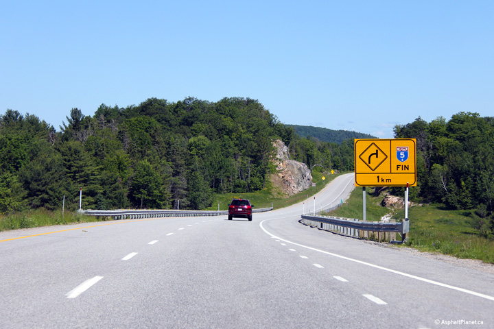
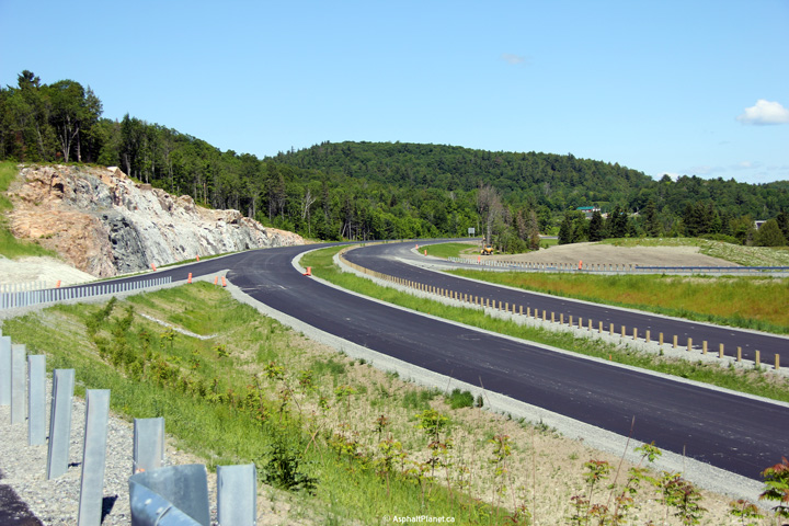
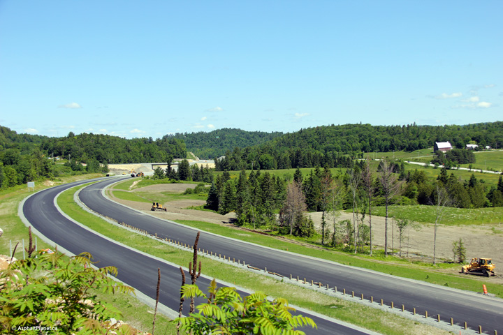
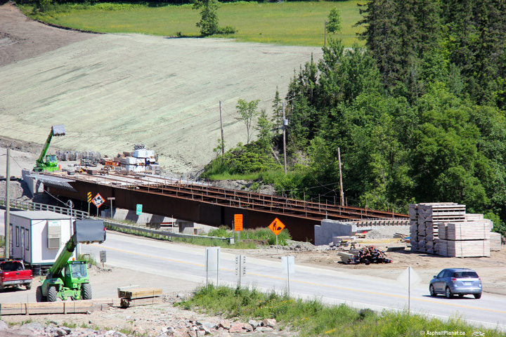
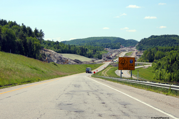
Some new pics of the Autoroute 5 extension north of Ottawa/Gatineau, taken last June:


More and larger:
http://www.asphaltplanet.ca/PQ/A/5/index.html
from the Canada forum
Reply With Quote
     
     
  #885  
Old Posted Dec 5, 2013, 3:27 AM
rocketphish's Avatar
rocketphish rocketphish is online now
Planet Ottawa and beyond
 
Join Date: Feb 2009
Location: Greater Ottawa
Posts: 14,655
$48M plan to widen three west-Ottawa roads

By Michael Aubry, Ottawa Sun


First posted: Wednesday, December 04, 2013 12:26 PM EST | Updated: Wednesday, December 04, 2013 12:38 PM EST

The city plans to spend $48 million to widen the Hope Side Rd., Old Richmond Rd. and West Hunt Club Rd. to make way for growing populations in Kanata, Stittsville and rural Ottawa.

A report to the city's transit committee recommends expanding the roads to four lanes while preserving natural conservation areas along the Greenbelt.

Wide cycling and pedestrian lanes would also be installed along the corridor.

The first part of the project - at $30.2 million - would expand Old Richmond and West Hunt Club roads from Hope Side Road to Hwy. 416 between 2014 and 2019.

The second phase would focus on Hope Side road and cost another $18 million.

"These existing two-lane roads have limited ability to absorb more traffic," the report states. The growing number of people moving to these budding communities is causing huge backlogs of traffic.

The road would have a central median built in, along with a two-metre raised cycling path and wide sidewalk in urban areas. A wide paved shoulder would be built in rural and Greenbelt areas.

The speed limits on the roads would vary from 60 to 80 km/h, which is in line with the posted limits in place now.

The project would also avoid damaging the Greenbelt as much as possible, including the popular Stony Swamp conservation area.

Along that route, the road will be realigned to deke around the Greenbelt and avoid the conservation area.

[email protected]

Twitter: @ottawasunmaubry

http://www.ottawasun.com/2013/12/04/48m-plan-to-widen-three-west-ottawa-roads
Reply With Quote
     
     
  #886  
Old Posted Dec 5, 2013, 5:16 PM
harls's Avatar
harls harls is offline
Mooderator
 
Join Date: Jan 2002
Location: Aylmer, Québec
Posts: 21,408
Quote:
Originally Posted by waterloowarrior View Post
from the Canada forum
A friend of mine just moved to Wakefield last summer, and she posted some pictures of her daughter motoring on her tricycle on that new strip of A-5.

I'm not going to post the pics, because the internet ruined everything (possible perverts).
Reply With Quote
     
     
  #887  
Old Posted Dec 18, 2013, 4:08 AM
matty14 matty14 is offline
Registered User
 
Join Date: Mar 2009
Posts: 139
Apologies if this has been posted elsewhere but anybody know what's happening on the east side of the Airport Parkway between Walkley and Brookfield? There has been a construction crew working there for over a month and there is now a SBGR installed on the east shoulder. Looks suspiciously like a widening project but I'm unsure. There also seemed to be a path leading from Walkley Station so could be a MUP as well.
Reply With Quote
     
     
  #888  
Old Posted Dec 18, 2013, 1:15 PM
TransitZilla TransitZilla is offline
Registered User
 
Join Date: Dec 2006
Posts: 2,800
Quote:
Originally Posted by matty14 View Post
Apologies if this has been posted elsewhere but anybody know what's happening on the east side of the Airport Parkway between Walkley and Brookfield? There has been a construction crew working there for over a month and there is now a SBGR installed on the east shoulder. Looks suspiciously like a widening project but I'm unsure. There also seemed to be a path leading from Walkley Station so could be a MUP as well.
It is a MUP; an extension of the Sawmill Creek pathway from Walkley to Brookfield.
Reply With Quote
     
     
  #889  
Old Posted Dec 18, 2013, 5:51 PM
lrt's friend lrt's friend is offline
Registered User
 
Join Date: Dec 2006
Posts: 12,805
Quote:
Originally Posted by bradnixon View Post
It is a MUP; an extension of the Sawmill Creek pathway from Walkley to Brookfield.
Aw, I always liked that path ending in the shrubbery at the Walkley transit station.

Nice to see a project actually being completed without waiting 20 years. The existing pathway is pretty well useless without a better connection into the rest of the bike trail network.

There is a lot of heavy equipment working on this project. I found that surprising.

I finally drove down the airport parkway and was surprised by how much of the pedestrian bridge was demolished. This project is cursed.
Reply With Quote
     
     
  #890  
Old Posted Dec 18, 2013, 6:20 PM
Catenary Catenary is offline
Registered User
 
Join Date: Dec 2012
Posts: 1,403
Quote:
Originally Posted by lrt's friend View Post
Aw, I always liked that path ending in the shrubbery at the Walkley transit station.

Nice to see a project actually being completed without waiting 20 years. The existing pathway is pretty well useless without a better connection into the rest of the bike trail network.

There is a lot of heavy equipment working on this project. I found that surprising.

I finally drove down the airport parkway and was surprised by how much of the pedestrian bridge was demolished. This project is cursed.
It will be a very useful trail. I took a cab by it and the driver was stunned when he asked what it was and I said bike path. There really is quite a bit of work going on there.

I don't know how much bridge was actually demolished, I thought it was mostly formwork taken down.
Reply With Quote
     
     
  #891  
Old Posted Dec 18, 2013, 7:25 PM
TransitZilla TransitZilla is offline
Registered User
 
Join Date: Dec 2006
Posts: 2,800
BTW, a diagram of this pathway extension can be found here:

http://ottawa.ca/sites/ottawa.ca/files/sawmill_walkbrook.pdf
Reply With Quote
     
     
  #892  
Old Posted Dec 19, 2013, 3:59 PM
Capital Shaun Capital Shaun is offline
Registered User
 
Join Date: May 2012
Location: Ottawa
Posts: 862
Quote:
Originally Posted by bradnixon View Post
BTW, a diagram of this pathway extension can be found here:

http://ottawa.ca/sites/ottawa.ca/files/sawmill_walkbrook.pdf
I'm getting a "Page not found" when clicking on that link.
Reply With Quote
     
     
  #893  
Old Posted Dec 19, 2013, 5:35 PM
eemy's Avatar
eemy eemy is offline
Closed account
 
Join Date: Aug 2006
Posts: 4,425
Works for me.
Reply With Quote
     
     
  #894  
Old Posted Dec 19, 2013, 6:07 PM
TransitZilla TransitZilla is offline
Registered User
 
Join Date: Dec 2006
Posts: 2,800
Quote:
Originally Posted by Capital Shaun View Post
I'm getting a "Page not found" when clicking on that link.
You can try getting to it from here:
http://ottawa.ca/en/sawmill-creek-pedestrian-and-cycling-pathway-extension
Reply With Quote
     
     
  #895  
Old Posted Dec 19, 2013, 8:50 PM
Capital Shaun Capital Shaun is offline
Registered User
 
Join Date: May 2012
Location: Ottawa
Posts: 862
Quote:
Originally Posted by bradnixon View Post
Thanks!
Reply With Quote
     
     
  #896  
Old Posted Dec 20, 2013, 4:38 AM
lrt's friend lrt's friend is offline
Registered User
 
Join Date: Dec 2006
Posts: 12,805
The Brookfield path is a rather peculiar location with some interesting history. If you walk along there, you will see fire hydrants, street lights, a railway level crossing with signals but no street. One of the trails ends at the edge of the Sawmill Creek. This area has changed substantially in the last 50 years.

Prior to the Airport Parkway, Brookfield Road (originally named Kilgour Road) was connected between Hog's Back and Heron Park. This why this odd level crossing exists with signals. Brookfield Road was named after the village of Brookfield which has completely disappeared. The preceding name, Kilgour Road was named after the founder of Brookfield. The trail that ends at the edge of the Sawmill Creek was the location of a bridge that connected Brookfield Road to the village of Brookfield on the south side of Sawmill Creek. The village was expropriated in the late 1950s to make way for the proposed Airport Parkway. The three streets of the village of were decommissioned in 1965 and the bridge was removed. The village also had a nickname, Pollacktown, because a number of the residents were of Polish descent. This was the days before political correctness. Most of the residents of this tiny village were market gardeners, before modern supermarkets put them out of business.

If you go to the Geo Ottawa map website, and look at the 1965 air photos you can vaguely see what was previously the village of Brookfield.
Reply With Quote
     
     
  #897  
Old Posted Dec 20, 2013, 6:14 AM
gjhall's Avatar
gjhall gjhall is offline
Registered User
 
Join Date: Aug 2009
Location: Ottawa
Posts: 1,297
Quote:
Originally Posted by lrt's friend View Post
The Brookfield path is a rather peculiar location with some interesting history. If you walk along there, you will see fire hydrants, street lights, a railway level crossing with signals but no street. One of the trails ends at the edge of the Sawmill Creek. This area has changed substantially in the last 50 years.

Prior to the Airport Parkway, Brookfield Road (originally named Kilgour Road) was connected between Hog's Back and Heron Park. This why this odd level crossing exists with signals. Brookfield Road was named after the village of Brookfield which has completely disappeared. The preceding name, Kilgour Road was named after the founder of Brookfield. The trail that ends at the edge of the Sawmill Creek was the location of a bridge that connected Brookfield Road to the village of Brookfield on the south side of Sawmill Creek. The village was expropriated in the late 1950s to make way for the proposed Airport Parkway. The three streets of the village of were decommissioned in 1965 and the bridge was removed. The village also had a nickname, Pollacktown, because a number of the residents were of Polish descent. This was the days before political correctness. Most of the residents of this tiny village were market gardeners, before modern supermarkets put them out of business.

If you go to the Geo Ottawa map website, and look at the 1965 air photos you can vaguely see what was previously the village of Brookfield.
Thanks for sharing this! I had no idea!
Reply With Quote
     
     
  #898  
Old Posted Jan 5, 2014, 5:40 AM
waterloowarrior's Avatar
waterloowarrior waterloowarrior is offline
National Capital Region
 
Join Date: Nov 2005
Location: Eastern Ontario
Posts: 9,254
Trim Road Widening update from the City
http://ottawa.ca/en/ott-city-online/video-trim-road-reconstruction-project-update
Video Link


Trim Road is a busy arterial road in the eastern end of Orléans. It serves as the only road access to Petrie Island and its public beach in the Ottawa River. It’s also the location of the Trim Transitway station.

Previously Trim Road was a two-lane roadway, which had rural cross sections and no formal sidewalks.

At the end of the project, Trim Road will have
  • four lanes: two northbound and two southbound
  • cycling lanes adjacent to the curb
  • grass boulevards between the roadway and the pathways
  • Old Montreal Road, east of Trim Road, will also be widened to improve the flow of traffic. In addition, St. Joseph Boulevard, west of Trim Road, will be widened from two to four lanes.

This work also includes the extension as well as replacement of key watermains.
Reply With Quote
     
     
  #899  
Old Posted Jan 7, 2014, 5:50 PM
rocketphish's Avatar
rocketphish rocketphish is online now
Planet Ottawa and beyond
 
Join Date: Feb 2009
Location: Greater Ottawa
Posts: 14,655
Macdonald-Cartier Bridge to undergo major renovation

By David Reevely, OTTAWA CITIZEN January 7, 2014 11:00 AM


OTTAWA — The Macdonald-Cartier Bridge is in for a major refit to replace worn-out parts and give it upgrades to better resist earthquakes, according to a tender posted by the Department of Public Works.

The job, valued at more than $5 million, is for a “seismic retrofit of the bridge and the rehabilitation of deteriorating components, specifically the deck, sidewalks, lighting system, barriers, concrete surfaces of pillars and abutments,” the documents say.

The work on the bridge that connects King Edward Avenue in Ottawa to Highway 5 in Quebec is to be done in conjunction with a city-run project to renovate the section of Sussex Drive that runs near the bridge.

It should all be completed within two years of the contracts’ being awarded after the bidding period closes in early February.

The tender documents specify that the contractor has to hire a “quality verification engineer,” a professional technical consultant qualified to work in both Ontario and Quebec, whose job is to provide expert monitoring of the construction work.

[email protected]

ottawacitizen.com/greaterottawa
© Copyright (c) The Ottawa Citizen

http://www.ottawacitizen.com/news/Macdon...ergo+major+renovation/9358616/story.html

Reply With Quote
     
     
  #900  
Old Posted Jan 9, 2014, 4:06 AM
rocketphish's Avatar
rocketphish rocketphish is online now
Planet Ottawa and beyond
 
Join Date: Feb 2009
Location: Greater Ottawa
Posts: 14,655
Traffic nightmare looms for users for Macdonald-Cartier Bridge

Public Works posts tender for extensive refit of 50-year-old span

By David Reevely and don butler, OTTAWA CITIZEN January 7, 2014


Commuters and truckers who use the Macdonald-Cartier Bridge should brace themselves for two years of traffic chaos.

The steel box girder bridge, built between 1964 and 1966, is about to undergo the most extensive refit in its history to replace worn-out parts and give it upgrades to better resist earthquakes, according to a tender posted by the Department of Public Works.

The 618-metre-long bridge that connects King Edward Avenue to Hwy. 5 in Quebec is a major transportation link between Ottawa and Gatineau, with average annual daily traffic of 70,000 vehicles. It’s also the main route for interprovincial trucking, handling more than 2,000 heavy trucks a day.

In the tender document, Public Works says the chosen contractor must do the work in a specific sequence to minimize its impact on the free flow of traffic. The department may reject work plans that “unduly penalize users when other solutions are available,” it says.

Still, it’s clear the project will be a royal pain for those who rely on the bridge. Work is scheduled to begin this spring and won’t be completed until the spring of 2016.

While complete bridge closures are not anticipated, “lane reductions will be required,” Public Works said in an email Tuesday. At times, the six-lane bridge will be down to a single lane in each direction, according to the tender document.

There will also be several short-term closures of exit and access ramps and the speed limit on the bridge will be reduced to 50 kilometres an hour for the duration of the work.

To minimize the impact of the work on bridge users, Public Works will issue notices informing the public in advance when lane closures are required.

Further complicating matters for motorists, the bridge work is to be done in conjunction with a city-run project to renovate a section of Sussex Drive from St. Patrick Street to King Edward Avenue.

That work, which includes the rehabilitation of the Sussex Drive Bridge over the Rideau River, won’t be finished until the end of this year.

The Macdonald-Cartier Bridge rehabilitation, valued at more than $5 million, is for a “seismic retrofit of the bridge and the rehabilitation of deteriorating components, specifically the deck, sidewalks, lighting system, barriers, concrete surfaces of pillars and abutments,” the tender documents say.

A description of the project on the Public Works website adds further details. Among other things, the project will widen the roadway in both directions, add a wider multi-use sidewalk for pedestrian and cyclist use, replace existing railings and install a new median.

The tender document specifies that the contractor has to hire a “quality verification engineer,” a professional technical consultant qualified to work in both Ontario and Quebec, whose job is to provide expert monitoring of the construction work.

[email protected]

[email protected]

ottawacitizen.com/greaterottawa
© Copyright (c) The Ottawa Citizen

http://www.ottawacitizen.com/news/Macdon...ergo+major+renovation/9358616/story.html

Reply With Quote
     
     
This discussion thread continues

Use the page links to the lower-right to go to the next page for additional posts
 
 
Reply

Go Back   SkyscraperPage Forum > Regional Sections > Canada > Ontario > Ottawa-Gatineau > Transportation
Forum Jump


Forum Jump


All times are GMT. The time now is 4:46 AM.


Powered by vBulletin® Version 3.8.7
Copyright ©2000 - 2026, vBulletin Solutions, Inc.