HomeDiagramsDatabaseMapsForum About
     

Go Back   SkyscraperPage Forum > Regional Sections > Canada > Alberta & British Columbia > Calgary > Transportation & Infrastructure


Closed Thread

 
Thread Tools Display Modes
     
     
  #5821  
Old Posted Dec 12, 2012, 11:19 PM
fusili's Avatar
fusili fusili is offline
Retrofit Urbanist
 
Join Date: Sep 2007
Posts: 6,692
Quote:
Originally Posted by RyLucky View Post
challenge accepted. I'll throw in Silverado and a few others free of charge.

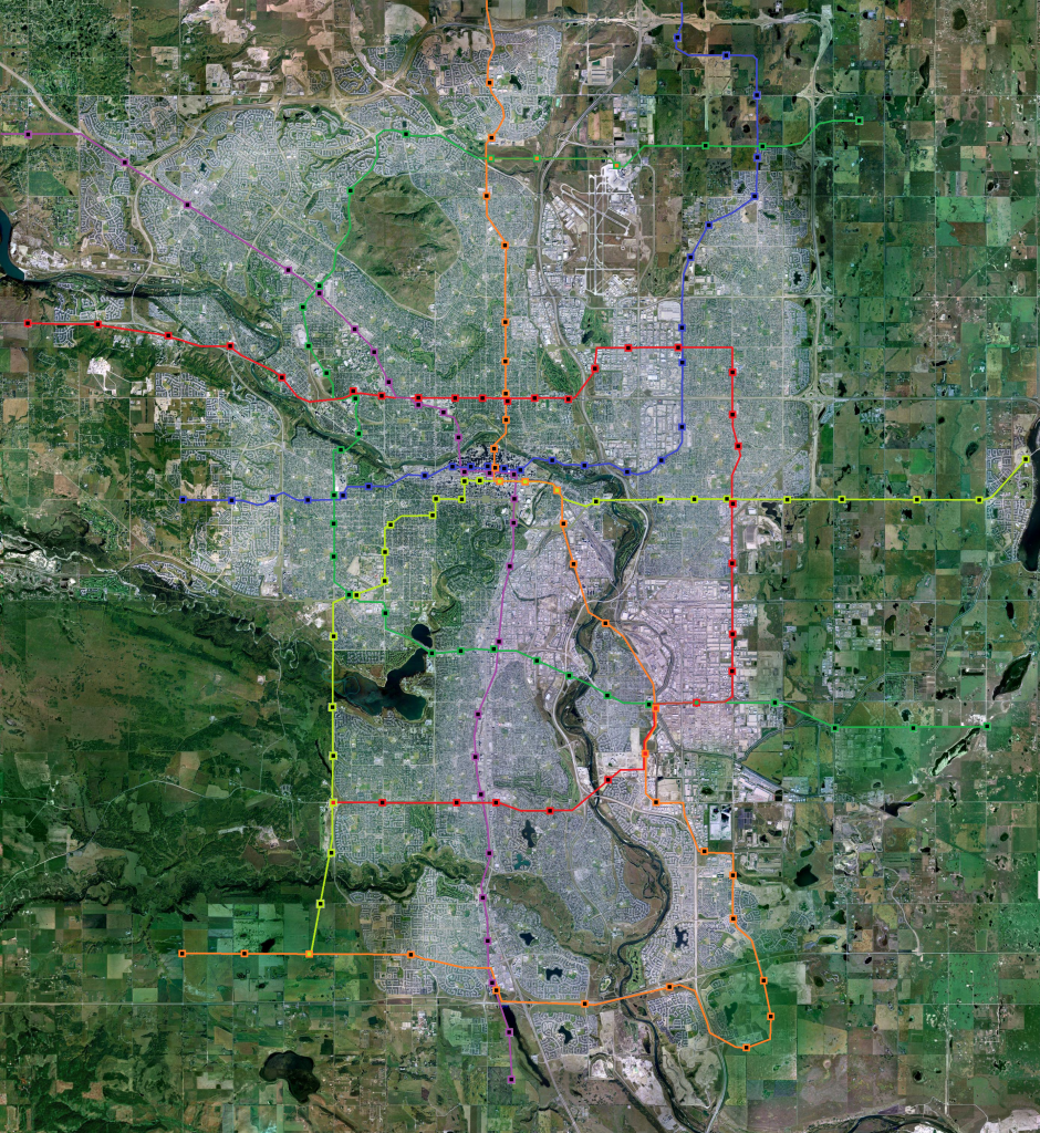
Actually, there are a lot of really great ideas in here. I like the idea of having the Bowness leg connect to Foothills on the 16th avenue line directly. (Downtown passengers can transfer to the NW or NC lines).

I also like the idea (albeit crazy) of having the 17th Ave SE line continue along 10th avenue, and then what looks like 8th ST/17th Ave/26th AV to get to MRU and then south. I always felt Bankview and South Calgary get the shaft in terms of transit.
__________________
Not everything that can be counted counts, and not everything that counts can be counted.
     
     
  #5822  
Old Posted Dec 12, 2012, 11:55 PM
tmjr tmjr is offline
Registered User
 
Join Date: May 2009
Location: Calgary
Posts: 122
I ask this having next to no transit planning insight at all. The green line running down 14th St. NW next to Nose Hill, wouldn't it be better to run down Shaganappi instead? Wouldn't that catch all those communities in the NW better, and also give good access to Northland and Market malls?

Edit - sorry - that line IS running down Shag... Thanks Eggbert!

Last edited by tmjr; Dec 13, 2012 at 1:38 AM.
     
     
  #5823  
Old Posted Dec 13, 2012, 12:11 AM
eggbert eggbert is offline
Registered User
 
Join Date: Jul 2008
Posts: 272
Quote:
Originally Posted by tmjr View Post
I ask this having next to no transit planning insight at all. The green line running down 14th St. NW next to Nose Hill, wouldn't it be better to run down Shaganappi instead? Wouldn't that catch all those communities in the NW better, and also give good access to Northland and Market malls?
That is Shaganappi, it's on the left (west) of Nose Hill vs the right (east).
     
     
  #5824  
Old Posted Dec 13, 2012, 1:37 AM
tmjr tmjr is offline
Registered User
 
Join Date: May 2009
Location: Calgary
Posts: 122
Quote:
Originally Posted by eggbert View Post
That is Shaganappi, it's on the left (west) of Nose Hill vs the right (east).
Doh! I don't know what I as thinking....

However, instead of Shag, perhaps it should go down Sarcee - there's lots of communities in that NW corner that seem far away from LRT...
     
     
  #5825  
Old Posted Dec 13, 2012, 3:09 AM
Just a Rider Just a Rider is offline
CT Rider Since 1989
 
Join Date: Dec 2012
Location: Calgary
Posts: 5
West LRT

Has anyone spotted a U2 set on the west line this week? Is there an operational reason for running them only on the NW and S lines?
     
     
  #5826  
Old Posted Dec 13, 2012, 3:11 AM
Bassic Lab Bassic Lab is offline
Registered User
 
Join Date: Oct 2005
Location: Calgary
Posts: 1,934
Quote:
Originally Posted by DizzyEdge View Post
Can anyone estimate how what percentage more infrastructure for LRT costs than infrastructure for streetcar? Just wondering if a future LRT is necessary to the airport if a streetcar might do. If lowfloor LRT only costs a bit more than streetcar infrastructure then might as well build it as LRT.
That depends on what you mean by streetcar and what you mean by LRT. If it's mixed traffic versus reserved ROW, then it could be a little if you're willing to take a driving lane or a lot if you have to expropriate valuable real estate. If it's one car consists versus multiple car consists, then it could be pretty cheap if you're willing to have bare bones low floor platforms.
     
     
  #5827  
Old Posted Dec 13, 2012, 3:24 AM
Aegis's Avatar
Aegis Aegis is offline
Analyst, Commercial Mtgs
 
Join Date: Sep 2006
Location: Bankview
Posts: 1,457
Wouldn't it be more efficient to have LRT lines that are diagonal to the boundaries of the city, as opposed to a grid of LRT lines?
     
     
  #5828  
Old Posted Dec 13, 2012, 3:27 AM
frinkprof's Avatar
frinkprof frinkprof is offline
Registered User
 
Join Date: Sep 2006
Location: The Gary
Posts: 4,865
^They struggle with the gradients on the west line.
     
     
  #5829  
Old Posted Dec 13, 2012, 3:43 AM
lucx lucx is offline
Registered User
 
Join Date: Mar 2008
Posts: 59
Quote:
Originally Posted by Just a Rider View Post
Has anyone spotted a U2 set on the west line this week? Is there an operational reason for running them only on the NW and S lines?
Also, SD's are stored at OBMF while U2's are stored at Anderson/Haysboro. SD's naturally start and remain on the NE/West Line
     
     
  #5830  
Old Posted Dec 13, 2012, 5:11 AM
Wigs's Avatar
Wigs Wigs is offline
Great White North
 
Join Date: Nov 2003
Location: Niagara Region
Posts: 16,536
Quote:
Originally Posted by Just a Rider View Post
Has anyone spotted a U2 set on the west line this week? Is there an operational reason for running them only on the NW and S lines?
on the grand opening I swear I saw a U2 sandwiched between two new SD160 NGs. or maybe I've been dreaming about the CTrain again
     
     
  #5831  
Old Posted Dec 13, 2012, 5:56 AM
RyLucky's Avatar
RyLucky RyLucky is offline
Registered User
 
Join Date: Feb 2012
Posts: 2,498
Quote:
Originally Posted by fusili View Post
Actually, there are a lot of really great ideas in here. I like the idea of having the Bowness leg connect to Foothills on the 16th avenue line directly. (Downtown passengers can transfer to the NW or NC lines).

I also like the idea (albeit crazy) of having the 17th Ave SE line continue along 10th avenue, and then what looks like 8th ST/17th Ave/26th AV to get to MRU and then south. I always felt Bankview and South Calgary get the shaft in terms of transit.
Thanks. My main critique of route ahead is all the disjointedness where there could be a continuous line, as I think you mentioned in a transitcamp post. I think they might eventually come to this conclusion as they set out to make functional plans. Some kind of SW line through the Beltline towards MRU would be great. It's really just a bit of fantasy.. if money was no object..


Quote:
Originally Posted by tmjr View Post
Doh! I don't know what I as thinking....

However, instead of Shag, perhaps it should go down Sarcee - there's lots of communities in that NW corner that seem far away from LRT...
Good point. If there's some way to bring it through more people that would be great. My thinking was there needs to be a crosstown route north of Nose Hill... and seeing as how there's a lot of employment around Market Mall, Northland, ACH, West Campus, Foothills... why not Shag?

Quote:
Originally Posted by Aegis View Post
Wouldn't it be more efficient to have LRT lines that are diagonal to the boundaries of the city, as opposed to a grid of LRT lines?
It ends up being kind of grid like in the south thanks to geographical constraints (reservoir, fish creek). My thinking here with this was to form hubs and better connect major suburban centres. Only so many lines need to go into downtown... I think I made 8 spokes... The whole system only has 6 lines, but they are each like 30km.

Again, it's all just fantasy. Maybe if one day I'm your benevolent dictator... and I have 30B dollars... and a construction crew of 100 000...


Last edited by RyLucky; Dec 13, 2012 at 6:09 AM.
     
     
  #5832  
Old Posted Dec 13, 2012, 7:26 AM
kw5150's Avatar
kw5150 kw5150 is offline
Here and There
 
Join Date: Nov 2009
Location: Calgary
Posts: 5,807
Quote:
Originally Posted by fusili View Post
One SE portion has to come first to accommodate a maintenance facility, as Chris Jordan (the RouteAhead lead) points out. Might as well go to Quarry Park first then up north second.

My plan, and the urbanist in me hates this somewhat, would be to build a massive park'n'ride at Quarry Park (2000 stalls or something) to accommodate the demand from the SE. Once the train is extended, build offices over the park'n'ride, or most of it anyway. That way commuters can avoid the Deerfoot bottleneck at the Ivor Strong Bridge.

And also pollute less. Sometimes it is about fresh air. Period.
__________________
Renfrew, Calgary, Alberta.
     
     
  #5833  
Old Posted Dec 13, 2012, 7:54 AM
ByeByeBaby's Avatar
ByeByeBaby ByeByeBaby is offline
Crunchin' the numbers.
 
Join Date: Mar 2009
Location: T2R, YYC, 403, CA-AB.
Posts: 791
Quote:
Originally Posted by fusili View Post
My plan, and the urbanist in me hates this somewhat, would be to build a massive park'n'ride at Quarry Park (2000 stalls or something) to accommodate the demand from the SE. Once the train is extended, build offices over the park'n'ride, or most of it anyway. That way commuters can avoid the Deerfoot bottleneck at the Ivor Strong Bridge.
I don't know to what degree it was planned originally and to what degree it's a happy accident, but the park and ride system is well suited for decades of evolution. People from beyond the end of the LRT will tend to want to stop at the first park n' ride and get a seat on the train, so the highest demand is at the end of the line. For instance, when Brentwood was the end of the line, it had to handle PnR from half of the northwest; now it really only serves Brentwood, Charleswood, Varsity and the communities along Shaganappi. So new, large park n' ride lots are built out past the big lot at Brentwood, and the more lightly used parking lot is prime redevelopment land, since it's no longer at the edge of the city.

My concern with Quarry Park is it may be a little too far out of the way to attract park and ride trips.
     
     
  #5834  
Old Posted Dec 13, 2012, 8:02 AM
ByeByeBaby's Avatar
ByeByeBaby ByeByeBaby is offline
Crunchin' the numbers.
 
Join Date: Mar 2009
Location: T2R, YYC, 403, CA-AB.
Posts: 791
Quote:
Originally Posted by Aegis View Post
Wouldn't it be more efficient to have LRT lines that are diagonal to the boundaries of the city, as opposed to a grid of LRT lines?
If I understand you correctly, you mean radiating out from the centre?

It's only efficient for commuters to and from the downtown, which is a nice big market. But only about 20% of the workforce is downtown, and (depending on how you cut it) 25% or so of trips are commute trips. So that's a market of 5-7%. The other 95% of trips need transit too, and going downtown is inconvenient for a lot of them. Someone from Beddington going to the U of C or Foothills, or someone from Killarney going to Chinook, or from Forest Lawn to the airport, or any of a thousand other OD pairs will find a grid convenient. I don't know if it all needs to be LRT (I'd be happier with 10 grid routes operating a true BRT service rather than one crosstown LRT for the same cost), but our next major transit project will provide most parts of the city with a direct connection to the downtown; we need to focus on planning for everything else now.
     
     
  #5835  
Old Posted Dec 13, 2012, 2:22 PM
Just a Rider Just a Rider is offline
CT Rider Since 1989
 
Join Date: Dec 2012
Location: Calgary
Posts: 5
Cool! Guaranteed A/C in the warmer weather. Thanks for the explanation.
     
     
  #5836  
Old Posted Dec 13, 2012, 3:04 PM
RyLucky's Avatar
RyLucky RyLucky is offline
Registered User
 
Join Date: Feb 2012
Posts: 2,498
Quote:
Originally Posted by ByeByeBaby View Post
I don't know to what degree it was planned originally and to what degree it's a happy accident, but the park and ride system is well suited for decades of evolution. People from beyond the end of the LRT will tend to want to stop at the first park n' ride and get a seat on the train, so the highest demand is at the end of the line. For instance, when Brentwood was the end of the line, it had to handle PnR from half of the northwest; now it really only serves Brentwood, Charleswood, Varsity and the communities along Shaganappi. So new, large park n' ride lots are built out past the big lot at Brentwood, and the more lightly used parking lot is prime redevelopment land, since it's no longer at the edge of the city.

My concern with Quarry Park is it may be a little too far out of the way to attract park and ride trips.
As a condition of building LRT to Quarry Park, IOL's staff parking should become a park'n'ride lot. (sorry, still a little bitter)
     
     
  #5837  
Old Posted Dec 13, 2012, 4:14 PM
freeweed's Avatar
freeweed freeweed is offline
Home of Hyperchange
 
Join Date: Sep 2006
Location: Dynamic City, Alberta
Posts: 17,568
I could be mistaken, but I'm pretty sure our LRT trains wouldn't be able to handle the incline going up Shaganappi on the Hill.

(Yes yes, I realize this is just someone having fun - but I couldn't help laughing at the thought of the LRT struggling up that bit. Half the cars in this city can't even keep their speed on that road)
__________________
Suburbs are the friends with benefits of the housing world.
     
     
  #5838  
Old Posted Dec 13, 2012, 4:15 PM
freeweed's Avatar
freeweed freeweed is offline
Home of Hyperchange
 
Join Date: Sep 2006
Location: Dynamic City, Alberta
Posts: 17,568
Quote:
Originally Posted by RyLucky View Post
As a condition of building LRT to Quarry Park, IOL's staff parking should become a park'n'ride lot. (sorry, still a little bitter)
I'd instead suggest that IOL fund the construction of the entire station and Park 'n Ride (I'm a lot more bitter).
__________________
Suburbs are the friends with benefits of the housing world.
     
     
  #5839  
Old Posted Dec 13, 2012, 4:25 PM
mersar's Avatar
mersar mersar is offline
Registered User
 
Join Date: May 2006
Location: Calgary, AB
Posts: 10,083
Quote:
Originally Posted by lucx View Post
Also, SD's are stored at OBMF while U2's are stored at Anderson/Haysboro. SD's naturally start and remain on the NE/West Line
Yep. The U2's will be rare on the 202 (or should I say Blue line) now, and from what was said on cptdb, CT is actively trying to not have them end up on it (there are some issues related to making it up the inline past Sarcee supposedly)
__________________

Live or work in the Beltline? Check out the Official Beltline web site here
     
     
  #5840  
Old Posted Dec 13, 2012, 5:03 PM
RyLucky's Avatar
RyLucky RyLucky is offline
Registered User
 
Join Date: Feb 2012
Posts: 2,498
Quote:
Originally Posted by freeweed View Post
I could be mistaken, but I'm pretty sure our LRT trains wouldn't be able to handle the incline going up Shaganappi on the Hill.

(Yes yes, I realize this is just someone having fun - but I couldn't help laughing at the thought of the LRT struggling up that bit. Half the cars in this city can't even keep their speed on that road)
In my vision, it's just BRT on Shag until 2027, at which time a new technology becomes available and the hill is no problem.
     
     
This discussion thread continues

Use the page links to the lower-right to go to the next page for additional posts
 
 
Closed Thread

Go Back   SkyscraperPage Forum > Regional Sections > Canada > Alberta & British Columbia > Calgary > Transportation & Infrastructure
Forum Jump


Forum Jump


All times are GMT. The time now is 9:51 AM.


Powered by vBulletin® Version 3.8.7
Copyright ©2000 - 2026, vBulletin Solutions, Inc.