HomeDiagramsDatabaseMapsForum About
     

Go Back   SkyscraperPage Forum > Regional Sections > Canada > Alberta & British Columbia > Calgary > Transportation & Infrastructure


Closed Thread

 
Thread Tools Display Modes
     
     
  #5221  
Old Posted Jul 31, 2012, 3:03 PM
93JC 93JC is offline
Registered User
 
Join Date: Jul 2006
Posts: 929
Quote:
Originally Posted by Comet View Post
Calgarians are more concerned with taking lessons from cities like Vancouver, Montreal and Toronto than worrying about the Regina, Saskatoons and Winnipegs.
I would like to say to the people of Winnipeg, on behalf of all Calgarians, that not all of us are as douchey as that^ guy.
     
     
  #5222  
Old Posted Jul 31, 2012, 3:44 PM
sim sim is offline
Registered User
 
Join Date: Aug 2008
Posts: 863
Quote:
Originally Posted by fusili View Post
These maps are illustrative of why transit costs so much money, but doesn't need to. Here is why:

- Routes 60/61 can be consolidated with route 159 simply with a small detour up to Saddlecrest Blvd. Why run an entire route that consists of a total of 5km?
- Routes 23 and 176 can be consolidated into a single express route running from Saddletowne station to Douglasdale station via 52nd street E. This can be operated similar to the 301 with limited stops and higher frequency
- Route 85 is useless. All it is doing is connecting LRT stations to one another. Service along Martindale Drive can be accommodated by altering the 60/61 to a figure-8 style loop instead of a regular circle.

With simple adjustments we can eliminate 3 of the 8 routes proposed above. And we wonder why transit is subsidized to such a degree.


Indeed. It was kind of fun to read the comment about Winnipeg's service then unsuspectingly scrolling down and being able to go "oh, and here's one reason why."


Quote:
Originally Posted by UofC.engineer View Post
Lol, bus service in Winnipeg SHOULD be better. I'd be shocked if it was worse.

1. Winnipeg is a smaller city, 700,000 people.

2. Winnipeg has no LRT

3. Winnipeg is an older city and has more of a grid layout for streets which is beneficial for transit.

Plus, seniors have a high transit ridership, median age in Winnipeg is like 58.

Essentially none of these are inherent and true causal reasons as to why it might have better bus service. You might get away with the gridded streets argument.
     
     
  #5223  
Old Posted Jul 31, 2012, 3:53 PM
fusili's Avatar
fusili fusili is offline
Retrofit Urbanist
 
Join Date: Sep 2007
Posts: 6,692
There is a lot to be said for simplicity and creating a grid network for transit. Jarrett Walker has written extensively on this, and it is something I think Calgary Transit needs to really consider.
__________________
Not everything that can be counted counts, and not everything that counts can be counted.
     
     
  #5224  
Old Posted Jul 31, 2012, 3:55 PM
MalcolmTucker MalcolmTucker is offline
Registered User
 
Join Date: May 2007
Posts: 11,596
Quote:
Originally Posted by fusili View Post
There is a lot to be said for simplicity and creating a grid network for transit. Jarrett Walker has written extensively on this, and it is something I think Calgary Transit needs to really consider.
I wonder what a grid optimization project would look like - selectively taking out houses and building bus only connectors to straighten out and make through routes.

Would be interesting to see if over the long haul it would end up saving money, or generate enough additional ridership to justify the expense.
     
     
  #5225  
Old Posted Jul 31, 2012, 3:59 PM
You Need A Thneed's Avatar
You Need A Thneed You Need A Thneed is offline
Construction Enthusiast
 
Join Date: Feb 2007
Location: Castleridge, NE Calgary
Posts: 5,892
Quote:
Originally Posted by fusili View Post
These maps are illustrative of why transit costs so much money, but doesn't need to. Here is why:

- Routes 60/61 can be consolidated with route 159 simply with a small detour up to Saddlecrest Blvd. Why run an entire route that consists of a total of 5km?
- Routes 23 and 176 can be consolidated into a single express route running from Saddletowne station to Douglasdale station via 52nd street E. This can be operated similar to the 301 with limited stops and higher frequency
- Route 85 is useless. All it is doing is connecting LRT stations to one another. Service along Martindale Drive can be accommodated by altering the 60/61 to a figure-8 style loop instead of a regular circle.

With simple adjustments we can eliminate 3 of the 8 routes proposed above. And we wonder why transit is subsidized to such a degree.
Route 159 and 85 will probably one have one bus assigned to each route at peak times. If you make the changes to combine routes as you suggest, more buses would be required on the other routes. The net is probably fairly even.

Route 176 only has a few trips in the morning and a few in the afternoon at peak times, and doesn't run otherwise. However, a 52nd St limited stop route would be great.
     
     
  #5226  
Old Posted Jul 31, 2012, 4:20 PM
fusili's Avatar
fusili fusili is offline
Retrofit Urbanist
 
Join Date: Sep 2007
Posts: 6,692
Quote:
Originally Posted by MalcolmTucker View Post
I wonder what a grid optimization project would look like - selectively taking out houses and building bus only connectors to straighten out and make through routes.

Would be interesting to see if over the long haul it would end up saving money, or generate enough additional ridership to justify the expense.
I was thinking more on the lines of creating limited stop cross-town routes using existing grid roads. The routes would either be true cross-towns or circulars (or semi-circulars):

N/S
- 68th ST E (future)
- 52nd ST E
- Barlow (from 32nd AV NE to Memorial)/36th (Memorial to Peigan)/Barlow (Peigan to 114th Ave/Douglasdale) (connects to future NC LRT at 40th Avenue)
- 14th ST NW/33rd Ave SW/Richmond Road
-

E/W
- Northmount/40th Avenue/32nd Avenue
- 16th Avenue NW/NE
- Route 305 (Bowness Road/Memorial/Kensington/9th Ave S/17th Ave SE)
- Richmond Road/33rd Av SW/Sifton/42nd Ave/Ogden Road/50th Ave SE
- 37th ST/Glenmore/14th ST SW/Heritage/Glenmore (Future route 306)
- Southland? (with new transit-only bridge over Bow to connect to Quarry park)
- Anderson? (Douglasdale-24th ST SW)
- 162nd Ave/Marquis of Lorne
__________________
Not everything that can be counted counts, and not everything that counts can be counted.
     
     
  #5227  
Old Posted Jul 31, 2012, 4:57 PM
fusili's Avatar
fusili fusili is offline
Retrofit Urbanist
 
Join Date: Sep 2007
Posts: 6,692
Quote:
Originally Posted by fusili View Post
I was thinking more on the lines of creating limited stop cross-town routes using existing grid roads. The routes would either be true cross-towns or circulars (or semi-circulars):

N/S
- 68th ST E (future)
- 52nd ST E
- Barlow (from 32nd AV NE to Memorial)/36th (Memorial to Peigan)/Barlow (Peigan to 114th Ave/Douglasdale) (connects to future NC LRT at 40th Avenue)
- 14th ST NW/33rd Ave SW/Richmond Road
- Elbow Dr
I forgot to mention Elbow Drive. The #3 can easily be upgraded to a 301-style limited stop service and will probably increase ridership considerably and cut down on operation costs. I don't see why the 50+ stops on the #3 on Elbow can't be cut to 20.
__________________
Not everything that can be counted counts, and not everything that counts can be counted.
     
     
  #5228  
Old Posted Jul 31, 2012, 6:07 PM
Comet Comet is offline
Registered User
 
Join Date: Jun 2012
Posts: 42
Quote:
Originally Posted by 93JC View Post
I would like to say to the people of Winnipeg, on behalf of all Calgarians, that not all of us are as douchey as that^ guy.
You should read the Winnipeg thread more often. Just defending my city that's all. 1.4 BILLION would go a long way to improve bus service in Calgary.
     
     
  #5229  
Old Posted Jul 31, 2012, 7:02 PM
kw5150's Avatar
kw5150 kw5150 is offline
Here and There
 
Join Date: Nov 2009
Location: Calgary
Posts: 5,807
Winnipeg has added 100,000 people in the last 30 years

1981 564,373

2011 663,617

Calgary in the same 30 years added 622, 982 people

1981 591 857

2011 1,214,839

I know this is not an excuse, but give Calgary bus service time to catch up. By the time we catch up with peoples' demands for certain areas, a whole other area of the city is fully built out.

Inner city bus transit is really good from what I have experienced so far. The applications to find your route are really good for the most part as well and pretty accurate.

It must be crazy at the transit meetings and determining how to tie in all of these new routes with limited funds.

Good job so far Calgary Transit, but it seems we can do better? I guess?
__________________
Renfrew, Calgary, Alberta.
     
     
  #5230  
Old Posted Jul 31, 2012, 7:17 PM
AgentGibb AgentGibb is offline
Registered User
 
Join Date: Jun 2011
Posts: 48
Quote:
Originally Posted by fusili View Post
I was thinking more on the lines of creating limited stop cross-town routes using existing grid roads. The routes would either be true cross-towns or circulars (or semi-circulars):
This. Calgary Transit needs to do this.

It's a cost-effective way of addressing what I consider the single biggest flaw with the CT network: If you're going downtown from most places it's fine. If you're going anywhere else forget about it (with a few exceptions).

Anecdotally, I believe this deficiency is what keeps a great many people (myself included) from riding transit on a regular basis.

I don't necessarily agree completely with fusili's proposed routes:
  • Generally I think these routes should pick a major road and follow it as much as possible:
    • It makes the system more intuitive to those already familiar with the road network.
    • Users can transfer to intersecting routes as needed.
    • Trying to predict people's trips is what got us into the current mess.
  • Missed a few roads that need this treatment IMO:
    • Country Hills Blvd
    • McKnight-John Laurie
    • Shaganappi
    • Sarcee
    • Beddington Tr (possibly)
    • Nose Hill Dr (possibly)

These are minor details, though. The concept is fantastic, and one I've been meaning to propose to the various RouteAhead-type organizations for a while now.
     
     
  #5231  
Old Posted Jul 31, 2012, 7:23 PM
fusili's Avatar
fusili fusili is offline
Retrofit Urbanist
 
Join Date: Sep 2007
Posts: 6,692
Quote:
Originally Posted by AgentGibb View Post
This. Calgary Transit needs to do this.

It's a cost-effective way of addressing what I consider the single biggest flaw with the CT network: If you're going downtown from most places it's fine. If you're going anywhere else forget about it (with a few exceptions).

Anecdotally, I believe this deficiency is what keeps a great many people (myself included) from riding transit on a regular basis.

I don't necessarily agree completely with fusili's proposed routes:
  • Generally I think these routes should pick a major road and follow it as much as possible:
    • It makes the system more intuitive to those already familiar with the road network.
    • Users can transfer to intersecting routes as needed.
    • Trying to predict people's trips is what got us into the current mess.
  • Missed a few roads that need this treatment IMO:
    • Country Hills Blvd
    • McKnight-John Laurie
    • Shaganappi
    • Sarcee
    • Beddington Tr (possibly)
    • Nose Hill Dr (possibly)

These are minor details, though. The concept is fantastic, and one I've been meaning to propose to the various RouteAhead-type organizations for a while now.
Agreed with you. The only reason some roads change (ex 32nd/40th/Northmount) is because the actual road changes names or one road ends and the route has to jog to get to another road or to access a C-Train station (i.e. Barlow route jogging to 36th street to intersect with Franklin Station, and jogging back because 36th doesn't go past Peigan). The routes are as straight as possible.

If you want to write about your suggestions, let me know, and I can help you write a blog on the TransitCamp website. Also, if you want to contact RouteAhead, I suggest you join TransitCamp, as we have an ongoing relationship with the RouteAhead team.

DM me for details.
__________________
Not everything that can be counted counts, and not everything that counts can be counted.
     
     
  #5232  
Old Posted Jul 31, 2012, 7:43 PM
AgentGibb AgentGibb is offline
Registered User
 
Join Date: Jun 2011
Posts: 48
Quote:
Originally Posted by fusili View Post
The routes are as straight as possible.
Fair point in general. The route that made me mention it as a minor point of disagreement was:
"14th ST NW/33rd Ave SW/Richmond Road"

If I understand what you describe there, you've got a N-S route essentially turning west. I'd rather see that continue to 14th Street SW using either Crowchild or Elbow for a short distance to get past the reservoir (or, ideally, some kind of busway across the dam at somewhat higher capital cost).


Quote:
Originally Posted by fusili View Post
If you want to write about your suggestions, let me know,
Will do. As I said, something I've been meaning to do for a while, just been too time constrained and/or lazy to do it properly (with maps and such).
     
     
  #5233  
Old Posted Jul 31, 2012, 7:56 PM
fusili's Avatar
fusili fusili is offline
Retrofit Urbanist
 
Join Date: Sep 2007
Posts: 6,692
Quote:
Originally Posted by AgentGibb View Post
Fair point in general. The route that made me mention it as a minor point of disagreement was:
"14th ST NW/33rd Ave SW/Richmond Road"

If I understand what you describe there, you've got a N-S route essentially turning west. I'd rather see that continue to 14th Street SW using either Crowchild or Elbow for a short distance to get past the reservoir (or, ideally, some kind of busway across the dam at somewhat higher capital cost).
Definitely a tough barrier to cross. I would be all for continuing a transit route along 14th street south, but crossing the causeway is a huge barrier. Definitely something that warrants further investigation.
__________________
Not everything that can be counted counts, and not everything that counts can be counted.
     
     
  #5234  
Old Posted Jul 31, 2012, 8:28 PM
andasen andasen is offline
Registered User
 
Join Date: Feb 2012
Location: Calgary
Posts: 227
Quote:
Originally Posted by fusili View Post
I was thinking more on the lines of creating limited stop cross-town routes using existing grid roads. The routes would either be true cross-towns or circulars (or semi-circulars):


E/W
- Northmount/40th Avenue/32nd Avenue
- 16th Avenue NW/NE
- Route 305 (Bowness Road/Memorial/Kensington/9th Ave S/17th Ave SE)
- Richmond Road/33rd Av SW/Sifton/42nd Ave/Ogden Road/50th Ave SE
- 37th ST/Glenmore/14th ST SW/Heritage/Glenmore (Future route 306)
- Southland? (with new transit-only bridge over Bow to connect to Quarry park)
- Anderson? (Douglasdale-24th ST SW)

- 162nd Ave/Marquis of Lorne
I think Southland would work best as part of a greater circular as I can never see the cost of a bridge being justifiable.

I'm thinking Soutland-Deerfoot-Bow Bottom
Then some choices you can either build a bus gate at Sikome to connect up to Sun Valley Blvd or continue on Bow Bottom down to 168th (would require road to be constructed) and then loop up to 37th via James McKevitt and Fish Creek Blvd. Then connect to Southland either by building an extention of 37th to Southland (even if transit only) or via Anderson-24th St)

Ya it would be easier to run this via Anderson but with the preference towards straightish routes I'd prefer to run an Anderson bus from the a stop on the SW BRT along Anderson, jogging onto Deerfoot for the river crossing and getting off on 24th to get to Douglasglen station then depending on demand eithering having all or some busses continue on 114th out to Shepard.
     
     
  #5235  
Old Posted Aug 1, 2012, 12:16 AM
UofC.engineer's Avatar
UofC.engineer UofC.engineer is offline
Laura Palmer
 
Join Date: Nov 2010
Location: Twin Peaks, Calgary, AB
Posts: 1,033
Quote:
Originally Posted by sim View Post
Essentially none of these are inherent and true causal reasons as to why it might have better bus service. You might get away with the gridded streets argument.
Yeah, I might juuussst might be able to squeak by with the grided streets arguement.

It's not like geography affects transit or anything, it's not that circular feeder routes generally have a lower transit ridership than direct routes. It's not like transfers are easier on a grided streets layout and in theory a person only really needs to make one transfer to get anywhere on a perfect grid. So I just might clear the bar with my last arguement.
     
     
  #5236  
Old Posted Aug 1, 2012, 2:06 AM
sim sim is offline
Registered User
 
Join Date: Aug 2008
Posts: 863
Quote:
Originally Posted by UofC.engineer View Post
Yeah, I might juuussst might be able to squeak by with the grided streets arguement.

It's not like geography affects transit or anything, it's not that circular feeder routes generally have a lower transit ridership than direct routes. It's not like transfers are easier on a grided streets layout and in theory a person only really needs to make one transfer to get anywhere on a perfect grid. So I just might clear the bar with my last arguement.

I never said it didn't, but that alone isn't a reason why you can't have proper service. Hence, why I mentioned that you only might get away with that argument. I mean, you've practically explained it yourself why it can't be used as a fully explanatory reason why service is bad. Just because you don't have perfectly gridded streets does not automatically mean you have to run circuitous routes. Continental Europe would be in trouble if that were the case - not that they have tonnes of curvilinear streets, but try and find a nice gridded city there. The key is having a network that mimics a grid, even if the geography doesn't exactly, as well as coordinated scheduling (ie. timed transfers). I believe some of the posters above me have already made that somewhat clear.

So yeah, you might juuussssttt sneak by with that argument, but in its essence, it's another copout. There is no inherent reason why Winnipeg SHOULD have better service. It likely has better service because either their transit budget per person is greater, all other things being essentially equal (which I doubt due to the LRT's ability to cross-subsidize the bus network) but I may be wrong, because they simply do a better job at tactically planning and operating their system, or because they have transportation policy favourable to a transit/bus system in general. Things I couldn't comment further on.

I am perhaps overly critical, but good service does not come about because there are lots of seniors, a lower population or because there is another mode of public transport in place. These are excuses, not casual reasons and therefore a barrier to actual improvement.

     
     
  #5237  
Old Posted Aug 1, 2012, 3:20 AM
You Need A Thneed's Avatar
You Need A Thneed You Need A Thneed is offline
Construction Enthusiast
 
Join Date: Feb 2007
Location: Castleridge, NE Calgary
Posts: 5,892
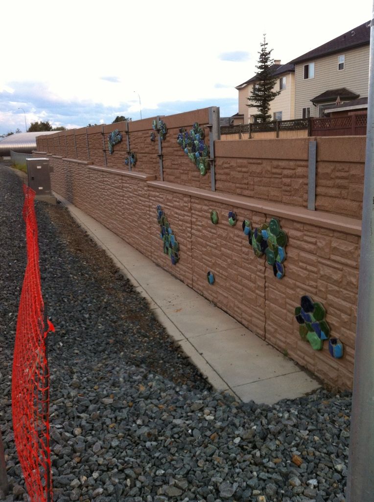
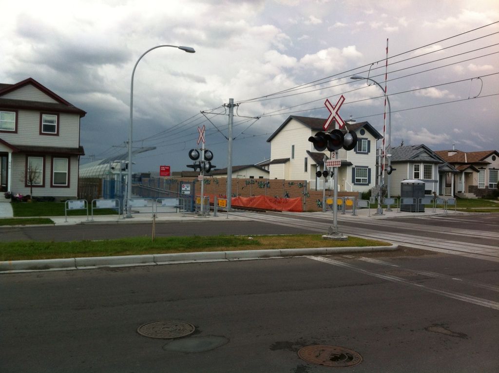
Here's a couple of pictures of the public art at Martindale Station.


  #5238  
Old Posted Aug 1, 2012, 4:42 AM
andasen andasen is offline
Registered User
 
Join Date: Feb 2012
Location: Calgary
Posts: 227
Quote:
Originally Posted by You Need A Thneed View Post
Here's a couple of pictures of the public art at Martindale Station.

<See Original Post for Images>
I'm trying see something in this but am failing miserably. It this the finished work? I'm kinda hoping its not else I'm giving this 'art' an F. All I see is random coloured things tacked on the wall. It is not representative of anything nor is it making a statement in its context.

I would much prefer it if I'm missing something so is anyone able to redeem this for me?
     
     
  #5239  
Old Posted Aug 1, 2012, 4:55 AM
CTrainDude CTrainDude is offline
Registered User
 
Join Date: Mar 2007
Posts: 517
Quote:
Originally Posted by andasen View Post
I'm trying see something in this but am failing miserably. It this the finished work? I'm kinda hoping its not else I'm giving this 'art' an F. All I see is random coloured things tacked on the wall. It is not representative of anything nor is it making a statement in its context.

I would much prefer it if I'm missing something so is anyone able to redeem this for me?
I can't say if the finished product will be good art, but it's not done. I believe, at a minimum, the final product is supposed to light up.
     
     
  #5240  
Old Posted Aug 1, 2012, 5:25 AM
andasen andasen is offline
Registered User
 
Join Date: Feb 2012
Location: Calgary
Posts: 227
Quote:
Originally Posted by CTrainDude View Post
I can't say if the finished product will be good art, but it's not done. I believe, at a minimum, the final product is supposed to light up.
My dying inside has been stalled with the option to complete upon opening of the station.
     
     
This discussion thread continues

Use the page links to the lower-right to go to the next page for additional posts
 
 
Closed Thread

Go Back   SkyscraperPage Forum > Regional Sections > Canada > Alberta & British Columbia > Calgary > Transportation & Infrastructure
Forum Jump


Forum Jump


All times are GMT. The time now is 4:17 AM.

     
SkyscraperPage.com - Privacy Statement - Top

Powered by vBulletin® Version 3.8.7
Copyright ©2000 - 2026, vBulletin Solutions, Inc.