HomeDiagramsDatabaseMapsForum About
     

Go Back   SkyscraperPage Forum > Regional Sections > Canada > Alberta & British Columbia > Calgary > Transportation & Infrastructure


Closed Thread

 
Thread Tools Display Modes
     
     
  #3621  
Old Posted Aug 6, 2011, 7:47 AM
Koolfire Koolfire is offline
Registered User
 
Join Date: Sep 2007
Posts: 374
Quote:
Originally Posted by frinkprof View Post
- I did actually share your sentiments about the lack of service on Bow Trail between Sarcee and 37th Streets, and have brought it up a couple of times at open houses. Still, the new route 6 covers for most of the gap. I've come around and I don't see it as the problem that I used to.
What about pushing 72/73 further west to like 69th instead of 37th? After the LRT starts on the map "BRT A" will run a very similar route to what 72/73 runs today on 37th.
     
     
  #3622  
Old Posted Aug 6, 2011, 6:29 PM
fusili's Avatar
fusili fusili is offline
Retrofit Urbanist
 
Join Date: Sep 2007
Posts: 6,692
Quote:
Originally Posted by DarkKeyo View Post
Since you first told me about this idea, I've been interested to know where you would put your high-frequency BRT's and LRT's. I assume the 6 radial LRT and 3 radial BRT corridors, as well as crosstown routes?
Actually, the plan I came up with for the BRT and LRT network is very similar to the City's LRT and BRT network plan (of course with a centre street LRT alignment). The important BRTs would be as follows:

1. The current 305- Bowness to International Avenue
2. 16th Avenue North- Peter Lougheed to Foothills/UofC
3. 52nd Street East- From Saddleridge station to SE Hospital (perhaps it will terminate on one SE LRT stations prior to that, which will act as a transfer station)
4. Westside connector- Westbrook/MRU/Rockyview/Heritage Station. Using 37th Street, Glenmore, 14th and Heritage. Future connection to SE LRT and 52nd Street BRT via Heritage and then Glenmore.
5. Marquis of Lorne Trail from Somerset to SE Hospital
6. Blackfoot BRT. From Heritage station via Heritage Drive, along Blackfoot and then continuing along to International Avenue.

This is very similar to the City's BRT network plan, with the addition of the Blackfoot BRT. All of these would utilize dedicated ROWs for the majority of their routes and would all be off-vehicle fare payments, multiple door boardings, signals control and limited stops (For example the BRT from Westbrook to Heritage would stop at 26th Avenue, Richmond Road, MRU, Richard Road Office Park, Rockyview Hospital, Heritage Park, Elbow Drive and Heritage Station).

__________________
Not everything that can be counted counts, and not everything that counts can be counted.
     
     
  #3623  
Old Posted Aug 6, 2011, 7:11 PM
DarkKeyo DarkKeyo is offline
Transit/Cartography Geek
 
Join Date: May 2008
Location: Burnaby
Posts: 332
Quote:
Originally Posted by fusili View Post
Actually, the plan I came up with for the BRT and LRT network is very similar to the City's LRT and BRT network plan (of course with a centre street LRT alignment). The important BRTs would be as follows:

1. The current 305- Bowness to International Avenue
2. 16th Avenue North- Peter Lougheed to Foothills/UofC
3. 52nd Street East- From Saddleridge station to SE Hospital (perhaps it will terminate on one SE LRT stations prior to that, which will act as a transfer station)
4. Westside connector- Westbrook/MRU/Rockyview/Heritage Station. Using 37th Street, Glenmore, 14th and Heritage. Future connection to SE LRT and 52nd Street BRT via Heritage and then Glenmore.
5. Marquis of Lorne Trail from Somerset to SE Hospital
6. Blackfoot BRT. From Heritage station via Heritage Drive, along Blackfoot and then continuing along to International Avenue.

This is very similar to the City's BRT network plan, with the addition of the Blackfoot BRT. All of these would utilize dedicated ROWs for the majority of their routes and would all be off-vehicle fare payments, multiple door boardings, signals control and limited stops (For example the BRT from Westbrook to Heritage would stop at 26th Avenue, Richmond Road, MRU, Richard Road Office Park, Rockyview Hospital, Heritage Park, Elbow Drive and Heritage Station).

I like all of those. I would add one, though: A connection between Lions Park/Banff Trail and Westbrook/Shaganappi Point. This would give you, essentially, a complete circle of crosstown routes, and add another connection over the river from NW to SW. I don't know how I would route it, as Crowchild Trail over the Bow River already can't handle the cars that go over it.

And with your BRT/LRT network in place, you would arrange routes around it so that they were feeder routes for stations, correct? As there already is on the LRT, but now including BRT. How well do you think people would adapt to a feeder bus to BRT bus transfer? With proper frequency, rapid transit design, etc, it could work.

Would you then eliminate many other routes to be replaced with feeders, or mostly just eliminate some bus stops in places where there are stops very close together?

I may draw a map of a system like this, to post here, just because I enjoy doing that. Once I get a proper drawing program to work.
     
     
  #3624  
Old Posted Aug 7, 2011, 4:13 PM
fusili's Avatar
fusili fusili is offline
Retrofit Urbanist
 
Join Date: Sep 2007
Posts: 6,692
Quote:
Originally Posted by DarkKeyo View Post
I like all of those. I would add one, though: A connection between Lions Park/Banff Trail and Westbrook/Shaganappi Point. This would give you, essentially, a complete circle of crosstown routes, and add another connection over the river from NW to SW. I don't know how I would route it, as Crowchild Trail over the Bow River already can't handle the cars that go over it.

And with your BRT/LRT network in place, you would arrange routes around it so that they were feeder routes for stations, correct? As there already is on the LRT, but now including BRT. How well do you think people would adapt to a feeder bus to BRT bus transfer? With proper frequency, rapid transit design, etc, it could work.

Would you then eliminate many other routes to be replaced with feeders, or mostly just eliminate some bus stops in places where there are stops very close together?

I may draw a map of a system like this, to post here, just because I enjoy doing that. Once I get a proper drawing program to work.
For the above point regarding the gap between Westbrook and Lion's Park/Banff Trail I may be completely crazy, but that is pretty much the only place I could see an urban gondola work. Like you said, Crowchild is already at capacity, the grade on the south bank of the river is incredibly steep west of Crowchild (so a LRT or BRT route may be incredibly difficult) and the next point of access to the SW is at Sarcee. A gondola could potentially work between Westbrook and Foothills Hospital with only two terminal stations. That would significantly reduce operating costs (as well as capital costs), and it join the SW to the Foothills/ACH/UofC area and vice versa. It may seem a little bit out there, but that is really the only place I could see an urban gondola working, and is probably the best solution to connect the NW and SW portions of the city.

And yes, most all other routes would be rearranged to be feeder routes. My belief is that any crosstown or downtown route should be high speed, high frequency and high capacity. Basically we would be designing a high frequency grid (of sorts) and then using feeders to connect people in.

Regarding the graphics, I have put it together in google earth, but I am thinking of slowly putting pieces together in Adobe Illustrator/Photoshop to improve the graphics.
__________________
Not everything that can be counted counts, and not everything that counts can be counted.
     
     
  #3625  
Old Posted Aug 8, 2011, 8:12 PM
You Need A Thneed's Avatar
You Need A Thneed You Need A Thneed is offline
Construction Enthusiast
 
Join Date: Feb 2007
Location: Castleridge, NE Calgary
Posts: 5,892
All four level crossings for the NE LRT extension are supposed to be complete today.

Enmax (I think they are doing the work) is starting to put up catenary poles just north of MKWW station.

Stations - 97% complete
Trackwork - tracks are installed the entire way, levelling and aligning to be done. Ballast appears to be in place.
Level Crossings - Complete
64th Ave tunnel - Complete - other than the repair of the crappy backfilling job they did this past weekend, which doesn't effect the LRT line work.
Catenary - poles have just started going up.
Signals - to be done yet too.

Certainly doesn't seem like 12 months of work left to do, even with testing time. Providing that they could get the tracks aligned and levelled before freezeup, everything else can easily continue through winter, if they couldn't get it done before then.
     
     
  #3626  
Old Posted Aug 9, 2011, 7:12 AM
that_twisted_cm that_twisted_cm is offline
Registered User
 
Join Date: Oct 2010
Posts: 36
Quote:
Originally Posted by You Need A Thneed View Post
All four level crossings for the NE LRT extension are supposed to be complete today.

Enmax (I think they are doing the work) is starting to put up catenary poles just north of MKWW station.

Stations - 97% complete
Trackwork - tracks are installed the entire way, levelling and aligning to be done. Ballast appears to be in place.
Level Crossings - Complete
64th Ave tunnel - Complete - other than the repair of the crappy backfilling job they did this past weekend, which doesn't effect the LRT line work.
Catenary - poles have just started going up.
Signals - to be done yet too.

Certainly doesn't seem like 12 months of work left to do, even with testing time. Providing that they could get the tracks aligned and levelled before freezeup, everything else can easily continue through winter, if they couldn't get it done before then.
Great news for sure! If it's a balmy fall and winter, they could get it done even sooner...maybe that's the plan all along, to get the NE extension ready first so that the West can be tested afterward?
     
     
  #3627  
Old Posted Aug 13, 2011, 2:02 AM
frinkprof's Avatar
frinkprof frinkprof is offline
Registered User
 
Join Date: Sep 2006
Location: The Gary
Posts: 4,865
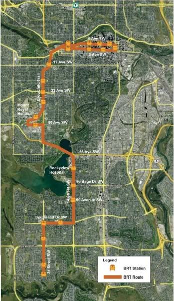
A couple of reports recently added to the CT Website:

Southwest BRT Functional Planning Study

- Goes over stop locations

- Cost is estimated to be just shy of $40M, including exclusive right of way on west side of 14th Street, 90th Ave. underpass and expansion of Crowchild Trail shoulder operation. It is mentioned that this estimate could vary wildly depending on the exact implementation of a few of the measures.

- Suggests possible shoulder operation on Glenmore Trail and/or southbound to eastbound flyover from Crowchild Trail to Glenmore Trail. These aren't included in cost estimate

- The terminus would be in Woodbine, a couple options are given for how that would operate.

- The study concludes that it would be a beneficial project to implement.


http://www.calgarytransit.com/pdf/calgary_sw_brt_funtional_planning_study_20110802.pdf

The Southeast BRT - Year One Report

For those that live in McDouglasdaleTowne - or worse - there was a report done to evaluate the SE BRT after one year of service, which was in August 2010. The report was published in June 2011, but was just added to the website.

It's fairly short, but the major points are:

- Travel time reliability improved

- Overall transit ridership in the southeast improved by 10% during a period where the system as a whole saw static ridership. Meanwhile service hours in the Southeast increased by 37%.

- Community routes in the southeast lost some ridership - likely due to people boarding the SE BRT directly instead.

- Tweaks to alleviate choke points are being looked at

- Service will be extended to the South Hospital area when it opens in late 2012 or early 2013

http://www.calgarytransit.com/pdf/se_brt_year_one_review_20110802.pdf
     
     
  #3628  
Old Posted Aug 13, 2011, 5:17 AM
DarkKeyo DarkKeyo is offline
Transit/Cartography Geek
 
Join Date: May 2008
Location: Burnaby
Posts: 332
Quote:
Originally Posted by frinkprof View Post
A couple of reports recently added to the CT Website:

Southwest BRT Functional Planning Study

- Goes over stop locations

- Cost is estimated to be just shy of $40M, including exclusive right of way on west side of 14th Street, 90th Ave. underpass and expansion of Crowchild Trail shoulder operation. It is mentioned that this estimate could vary wildly depending on the exact implementation of a few of the measures.

- Suggests possible shoulder operation on Glenmore Trail and/or southbound to eastbound flyover from Crowchild Trail to Glenmore Trail. These aren't included in cost estimate

- The terminus would be in Woodbine, a couple options are given for how that would operate.

- The study concludes that it would be a beneficial project to implement.
I agree that this would be beneficial, but for a slightly different reason than they are using. If this were to be completed soon after the West LRT opens, then the portion from downtown to MRU would do an excellent job of carrying the rerouted 301, and the portion from MRU to Heritage Drive would be perfect for carrying part of the unnumbered BRT that will go from Westbrook to Heritage. This, to me, is more important than building it all the way to Woodbine.

The next BRT corridor I would like to see a study for is the 16th Av corridor. Not least because I live quite close to it now, and am finding Route 19 awkward to use to get anywhere.
     
     
  #3629  
Old Posted Aug 13, 2011, 5:46 PM
MalcolmTucker MalcolmTucker is offline
Registered User
 
Join Date: May 2007
Posts: 11,612
Quote:
This, to me, is more important than building it all the way to Woodbine.
I agree on this part. It is troubling that much of the capital expenditures goes to the 90th Ave tunnel, which could be a throw away once capacity issues on the south line are dealt with. Before approving that part I would want a study that shows real travel time improvements vs skip aheads for feeder buses across 14th St and approaching LRT stations from communities south of Heritage. $40 million isn't a huge expenditure to be true, but it would be a shame for it to be a waste. I would also want an operational expenditure projection vs improved feeder bus service feeding to the south line.

I would also want a study that shows capacity, including what the maximum people per direction per hour would be before it would cause the 14th St exit from Glenmore to completely back up due to the new intersection. Since that area is part of the more core BRT network, perhaps it should have the tunnel instead of at 90th if it is the real choke point and will be used by more routes.

I would have to dig out plan it, but it all comes back to the fact that this is a pet project that wasn't identified on long term plans as being needed (I could be wrong, and haven't checked). Ad-hoc planning opens the system up to the travails most other municipalities seem to have in transit planning, where the planning is subject to the whims of today's council, instead of conforming to a long term plan. It opens up the system to spending capital on small piecemeal efforts which when taken together start to have material impact on the ability to get large projects done.
     
     
  #3630  
Old Posted Aug 13, 2011, 6:06 PM
fusili's Avatar
fusili fusili is offline
Retrofit Urbanist
 
Join Date: Sep 2007
Posts: 6,692
Quote:
Originally Posted by MalcolmTucker View Post
I would have to dig out plan it, but it all comes back to the fact that this is a pet project that wasn't identified on long term plans as being needed (I could be wrong, and haven't checked). Ad-hoc planning opens the system up to the travails most other municipalities seem to have in transit planning, where the planning is subject to the whims of today's council, instead of conforming to a long term plan. It opens up the system to spending capital on small piecemeal efforts which when taken together start to have material impact on the ability to get large projects done.
Quoted for truth. Another illustration of the need for a long-term complete network plan. Piecemeal additions and ad hoc planning is a poor way to create a good transit system.
__________________
Not everything that can be counted counts, and not everything that counts can be counted.
     
     
  #3631  
Old Posted Aug 13, 2011, 6:39 PM
Socguy Socguy is offline
Registered User
 
Join Date: May 2008
Posts: 494
Sooner rather than later.

I'm biased because I live deep in the SW but to me this project is such a big deal that I would strongly support running the route within existing traffic while the dedicated infrastructure they spoke about is under construction/study. In fact, if they were to simply start running this route tomorrow, I think people would be shocked by the ridership they see. Mount Royal University in particular needs a route like this for September!

Having said all that, the City must be careful with 14th st SW. Unless or until the SWRR is complete it is such a vital link that it can't tolerate much delay.
     
     
  #3632  
Old Posted Aug 13, 2011, 6:47 PM
MalcolmTucker MalcolmTucker is offline
Registered User
 
Join Date: May 2007
Posts: 11,612
The question of the day is whether it would generate new ridership, or mostly just shift ridership off the south line. If mostly a shift, once 4 car operations became the norm the route should be cancelled, and people going to MRU will just have to deal with feeder bus --> LRT --> BRT. The infrastructure is a long term solution to a short term problem, a problem that may not exist by the time any infrastructure would be done. (the problem being the difficulty of people boarding at peak at mid-line stations)
     
     
  #3633  
Old Posted Aug 14, 2011, 12:50 AM
5seconds 5seconds is offline
Closed account
 
Join Date: Mar 2011
Posts: 935
Can someone explain this one to me?


There is no way of building 2 more lanes and retaining the central median along 14h street, is there? Are they planning to expropriate? I thought there wasn't room, but I could be wrong.
     
     
  #3634  
Old Posted Aug 14, 2011, 4:44 AM
UofC.engineer's Avatar
UofC.engineer UofC.engineer is offline
Laura Palmer
 
Join Date: Nov 2010
Location: Twin Peaks, Calgary, AB
Posts: 1,033
Quote:
Originally Posted by MalcolmTucker View Post
The question of the day is whether it would generate new ridership, or mostly just shift ridership off the south line. If mostly a shift, once 4 car operations became the norm the route should be cancelled, and people going to MRU will just have to deal with feeder bus --> LRT --> BRT. The infrastructure is a long term solution to a short term problem, a problem that may not exist by the time any infrastructure would be done. (the problem being the difficulty of people boarding at peak at mid-line stations)
I think if the trip time for the SW BRT is reasonable(30 mins from terminus to terminus) the service will generate new ridership and take away ridership from the south line.

However I respectfully disagree that the service should be taken away once 4-car trains are implemented. As the T.O.D.'s along the south line develop(however slow that may be) and Greentrip commuter buses from Okotoks and High River get rolling, more people are going to use the south line for downtown commuting purposes.
     
     
  #3635  
Old Posted Aug 14, 2011, 4:51 AM
Porfiry Porfiry is offline
Registered User
 
Join Date: May 2010
Posts: 802
Quote:
Originally Posted by 5seconds View Post
There is no way of building 2 more lanes and retaining the central median along 14h street, is there? Are they planning to expropriate? I thought there wasn't room, but I could be wrong.
Correct, there's a few meters of grass on the east side, but not enough for two lanes. The drawings in the report show them trimming a few meters off the roads and properties on the east side, which would probably involve demolishing two or three homes.
     
     
  #3636  
Old Posted Aug 14, 2011, 8:47 AM
armorand93's Avatar
armorand93 armorand93 is offline
Transit Nerd
 
Join Date: Nov 2010
Location: Calgary (former Winnipegger)
Posts: 2,707
Could do one on each side of the roadway. They might do it in Winnipeg with Pembina Highway (our version of MacLeod Trail)
     
     
  #3637  
Old Posted Aug 14, 2011, 2:34 PM
5seconds 5seconds is offline
Closed account
 
Join Date: Mar 2011
Posts: 935
Quote:
Originally Posted by Porfiry View Post
Correct, there's a few meters of grass on the east side, but not enough for two lanes. The drawings in the report show them trimming a few meters off the roads and properties on the east side, which would probably involve demolishing two or three homes.
Where does it show that? The only reference I can see is on page 13 where it says "The cross section in Figure 8 demonstrates that the added bus lanes can be constructed within the existing roadway and without affecting any existing travel lanes"

Which indicates (to me) that they are not trimming anything off the surrounding houses. Looking at the diagram again, the median is 2m narrower, and each lane is 20cm narrower than south of Heritage, I wonder how that will affect speed limits along 14th. (Also, since when is narrowing lanes NOT 'affecting existing travel lanes'? )

EDIT:

I also noticed that on page 13 they state that "14 street is built to a different standard than Crowchild Trail or Glenmore Trail, meaning bus-lanes in the shoulders is not possible. Construction of new lanes for buses would be required..."

If they are going to construct new lanes anyway, why would it make more sense to group both directions on one side of the road? It seems like the hassle of getting the north-bound buses on and off of the new lanes at Southland and Rockyview Hospital would make this less efficent than just extending the existing shoulders to a full lane width? And it can't just be for the underpass, because the north-bound lane would bypass the 90th intersection altogether anyway by having it on the East side of the road... I'm not sure I understand this grouping.

Finally, if they have that concrete barrier on one side of the bus lanes, and the noise barrier on the other, how in the world are they going to plow the snow?

Generally I like what they are doing, and that part of Calgary desperately needs the connection. I still think that 14th could be free-flowed, and the money they use for any kind of 90th underpass would be better spent being put towards an actual 90th interchange.

Last edited by 5seconds; Aug 14, 2011 at 4:06 PM.
     
     
  #3638  
Old Posted Aug 14, 2011, 4:50 PM
5seconds 5seconds is offline
Closed account
 
Join Date: Mar 2011
Posts: 935
Quote:
Originally Posted by MalcolmTucker View Post
I would also want a study that shows capacity, including what the maximum people per direction per hour would be before it would cause the 14th St exit from Glenmore to completely back up due to the new intersection. Since that area is part of the more core BRT network, perhaps it should have the tunnel instead of at 90th if it is the real choke point and will be used by more routes.
Which new intersection are you talking about? I am interested to see how they deal with the Hospital road network and Heritage intersections though. I assume these would just be prioritised traffic light intersections.

Quote:
Originally Posted by MalcolmTucker View Post
I would have to dig out plan it, but it all comes back to the fact that this is a pet project that wasn't identified on long term plans as being needed (I could be wrong, and haven't checked). Ad-hoc planning opens the system up to the travails most other municipalities seem to have in transit planning, where the planning is subject to the whims of today's council, instead of conforming to a long term plan. It opens up the system to spending capital on small piecemeal efforts which when taken together start to have material impact on the ability to get large projects done.
The document says that this is part of a Primary Transit Network which is a part of the Calgary Transportation Plan. The network is a framework of corridors that, while identified as important areas, do not have specific modes or infrastructure identified for service. These studies are part of the process of identifying the best way to service these corridors. I'm not sure it's fair to characterise the SW BRT as Ad-hoc planning, though I am frequently wrong about these things! I don't really know the background in all of this.

Last edited by 5seconds; Aug 14, 2011 at 5:08 PM.
     
     
  #3639  
Old Posted Aug 14, 2011, 6:53 PM
Porfiry Porfiry is offline
Registered User
 
Join Date: May 2010
Posts: 802
Quote:
Originally Posted by 5seconds View Post
Where does it show that? The only reference I can see is on page 13 where it says "The cross section in Figure 8 demonstrates that the added bus lanes can be constructed within the existing roadway and without affecting any existing travel lanes"
See the 3rd to last page of this document -- keep in mind this is just a consultant's report and not an official plan of any sort. I'm just eyeballing it, but it certainly looks like the existing sound barrier would be moved, as all travel lanes would be shifted to the east.

http://www.calgarytransit.com/pdf/calgary_sw_brt_funtional_planning_study_20110802.pdf
     
     
  #3640  
Old Posted Aug 14, 2011, 7:27 PM
5seconds 5seconds is offline
Closed account
 
Join Date: Mar 2011
Posts: 935
Quote:
Originally Posted by Porfiry View Post
See the 3rd to last page of this document -- keep in mind this is just a consultant's report and not an official plan of any sort. I'm just eyeballing it, but it certainly looks like the existing sound barrier would be moved, as all travel lanes would be shifted to the east.

http://www.calgarytransit.com/pdf/calgary_sw_brt_funtional_planning_study_20110802.pdf
Thanks for the link! I only had the more limited version without all of those drawings.

You're right, it looks like there would be a slight shift East based on these drawings. I believe there are 2 houses that would not survive such a shift.

I find it interesting that they would implement an underpass rather than a grade crossing with traffic lights at 90th. As long as there is lights at 14th and 90th anyway, I think that just having the dedicated lanes would be enough to not need an underpass as well, especially as the lights are (I believe) prioritised towards N-S travel on 14th. If you have eliminated 90% of the obstacles that create slow-down over the course of the route, then that would be the one piece of the plan that could be left at-grade and not create much of a problem overall, IMO.
     
     
This discussion thread continues

Use the page links to the lower-right to go to the next page for additional posts
 
 
Closed Thread

Go Back   SkyscraperPage Forum > Regional Sections > Canada > Alberta & British Columbia > Calgary > Transportation & Infrastructure
Forum Jump


Forum Jump


All times are GMT. The time now is 5:21 PM.


Powered by vBulletin® Version 3.8.7
Copyright ©2000 - 2026, vBulletin Solutions, Inc.