HomeDiagramsDatabaseMapsForum About
     

Go Back   SkyscraperPage Forum > Regional Sections > Canada


Reply

 
Thread Tools Display Modes
     
     
  #61  
Old Posted Jul 3, 2011, 2:14 PM
Jamaican-Phoenix's Avatar
Jamaican-Phoenix Jamaican-Phoenix is offline
 
Join Date: Jun 2007
Posts: 3,561
Quote:
Originally Posted by vid View Post
In 2006, Ontario has 745,372. Most of them live in small towns. I think only PEI is less urban than Northern Ontario. Only 64% of Northern Ontarians live in communities with more than 10,000 people.

And as Someone123 mentioned, there are downsides to population growth, like this and this. A lot of people in Canada have yet to find out about the mining boom that is beginning to pick up steam here.
I'm aware of the mining book beginning in Northwestern Ontario in Ontario's "Ring of Fire" I believe it's called.
Reply With Quote
     
     
  #62  
Old Posted Jul 3, 2011, 6:10 PM
vid's Avatar
vid vid is offline
 
Join Date: Apr 2004
Posts: 39,065
The Ring of Fire is just a single area, like the oil sands near Fort McMurray. There are other large deposits that are being investigated. There is a lot of activity near Atikokan and in the Sudbury area as well.

Most of the world's mining activity is currently happening in the Canadian Shield region from northern Manitoba to Ungava, and Northern Ontario is in the middle of it and has the most to gain.

Quebec actually released something called Plan Nord recently, which is similar to what Northern Ontario needs. Northern Quebeckers are getting $80B in investment, Northern Ontarians are getting a think tank.
Reply With Quote
     
     
  #63  
Old Posted Jul 3, 2011, 6:39 PM
Mister F Mister F is offline
 
Join Date: Jun 2004
Posts: 2,990
Quote:
Originally Posted by vid View Post
The region is about 800,000km, two thirds are shield (and everyone lives in that region except 6,000 aboriginals in the lowlands), so that region is about 550,000sqkm in size. I would guess around 350sqkm are developed with cities and towns, so about 0.064% of Ontario's Sheild region has been developed for homes and businesses. It probably goes up to 0.1% when you include mines, and about 3% when you include logging. That's just Northern Ontario's part of the shield, the southern Ontario highlands (Muskokas, Algonquin, Peteroborough/Kawartha Lakes/west of Ottawa) are more developed. But probably not more than 3 or 4 per cent overall.
Actually Peterborough and most of the Kawartha Lakes aren't on the Shield at all. With the exception of Stoney and Lower Buckhorn Lakes, the Kawarthas are surrounded by farmland and don't look anything like Muskoka. If you look at air photos you can see a line north of Peterborough where the farmland ends and the Shield begins. The population density drops off pretty drastically at that point.
Reply With Quote
     
     
  #64  
Old Posted Jul 3, 2011, 7:24 PM
vid's Avatar
vid vid is offline
 
Join Date: Apr 2004
Posts: 39,065
Well it doesn't have the outcroppings but it has the swamps and lakes everywhere, so it isn't too dissimilar.
Reply With Quote
     
     
  #65  
Old Posted Jul 3, 2011, 9:33 PM
Mister F Mister F is offline
 
Join Date: Jun 2004
Posts: 2,990
Quote:
Originally Posted by vid View Post
Well it doesn't have the outcroppings but it has the swamps and lakes everywhere, so it isn't too dissimilar.
Trust me vid, it's very dissimilar from the Shield. It's typical southern Ontario farmland. The countryside surrounding Peterborough and the near-wilderness half an hour to the north couldn't be more different. By the way, wetlands are common all over southern Ontario.
Reply With Quote
     
     
  #66  
Old Posted Jul 3, 2011, 11:07 PM
Architype's Avatar
Architype Architype is offline
 
Join Date: Mar 2004
Posts: 14,085
Quote:
Originally Posted by vid View Post
Quebec actually released something called Plan Nord recently, which is similar to what Northern Ontario needs. Northern Quebeckers are getting $80B in investment, Northern Ontarians are getting a think tank.
I believe Plan Nord includes plans for a highway link which will connect the Southern Labrador & Quebec North Shore coast, it might help a bit with the economy & population growth in the region ... ("Extend Highway 138 by building a link between Kegaska and Blanc-Sablon").

http://www.mrnf.gouv.qc.ca/english/mines/quebec-mines/2011-06/plannord.asp
Reply With Quote
     
     
  #67  
Old Posted Jul 4, 2011, 11:31 PM
canadaonstrike canadaonstrike is offline
 
Join Date: Jun 2011
Posts: 31
Is it safe to say the majority of NON-canadian shield land in Ontario has been developed?
Reply With Quote
     
     
  #68  
Old Posted Jul 5, 2011, 12:14 AM
freeweed's Avatar
freeweed freeweed is offline
 
Join Date: Sep 2006
Posts: 17,568
Quote:
Originally Posted by canadaonstrike View Post
Is it safe to say the majority of NON-canadian shield land in Ontario has been developed?
Non-Canadian land ... in Canada?
Reply With Quote
     
     
  #69  
Old Posted Jul 5, 2011, 12:36 AM
Jamaican-Phoenix's Avatar
Jamaican-Phoenix Jamaican-Phoenix is offline
 
Join Date: Jun 2007
Posts: 3,561
Quote:
Originally Posted by canadaonstrike View Post
Is it safe to say the majority of NON-canadian shield land in Ontario has been developed?
Look no further than the span of Ontario between Michigan and Quebec.
Reply With Quote
     
     
  #70  
Old Posted Jul 5, 2011, 1:57 AM
eemy's Avatar
eemy eemy is offline
 
Join Date: Aug 2006
Posts: 4,425
Quote:
Originally Posted by canadaonstrike View Post
Is it safe to say the majority of NON-canadian shield land in Ontario has been developed?
Strictly speaking, no; however, the vast majority of land which makes sense to develop (including for agriculture) has been, the only exceptions generally being conservation land.
Reply With Quote
     
     
  #71  
Old Posted Jul 5, 2011, 2:29 AM
canadaonstrike canadaonstrike is offline
 
Join Date: Jun 2011
Posts: 31
Quote:
Originally Posted by freeweed View Post
Non-Canadian land ... in Canada?
Learn to.... read?
Reply With Quote
     
     
  #72  
Old Posted Jul 5, 2011, 2:30 AM
canadaonstrike canadaonstrike is offline
 
Join Date: Jun 2011
Posts: 31
Quote:
Originally Posted by jeremy_haak View Post
Strictly speaking, no; however, the vast majority of land which makes sense to develop (including for agriculture) has been, the only exceptions generally being conservation land.
Interesting, thanks.
Reply With Quote
     
     
  #73  
Old Posted Jul 5, 2011, 3:24 AM
eternallyme eternallyme is offline
 
Join Date: Mar 2009
Posts: 5,243
Quote:
Originally Posted by vid View Post
Twinning 11/17 along the north shore, from Nipigon to Sault Ste. Marie, is estimated to cost at least a billion dollars. There would likely be situations where eastbound traffic and westbound traffic is separated by medians that are kilometres wide, or major realignments, because the terrain can't accept a wider road. It's similar to BC's coastal highways, except the top 80% of the mountains is cut off. Where the road is built, though, is very similar terrain.
I would say that section would cost about $15 million a kilometre on average, resulting in a cost of about $8.7 billion (about one-third of the total cost from Manitoba to Ottawa). The only real breaks in the high expenses there would be from about Marathon to Wawa where the terrain is more forgiving - the rest is very difficult. It would easily be the most difficult highway project in Ontario history. Several tunnels and viaducts could also be required.
Reply With Quote
     
     
  #74  
Old Posted Jul 5, 2011, 3:35 AM
waterloowarrior's Avatar
waterloowarrior waterloowarrior is offline
 
Join Date: Nov 2005
Posts: 9,255
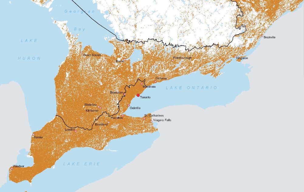
Converted Natural Areas in Southern Ontario

http://www.longpointlandtrust.ca/about/
Reply With Quote
     
     
  #75  
Old Posted Jul 5, 2011, 5:10 AM
freeweed's Avatar
freeweed freeweed is offline
 
Join Date: Sep 2006
Posts: 17,568
Quote:
Originally Posted by canadaonstrike View Post
Learn to.... read?
Learn to ... use hyphens properly?
Reply With Quote
     
     
  #76  
Old Posted Jul 5, 2011, 7:52 AM
Blue 24's Avatar
Blue 24 Blue 24 is offline
 
Join Date: May 2006
Posts: 175
having more kids maybe?
Reply With Quote
     
     
  #77  
Old Posted Jul 5, 2011, 1:05 PM
MolsonExport's Avatar
MolsonExport MolsonExport is offline
 
Join Date: Oct 2003
Posts: 51,828

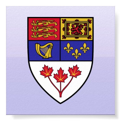
rlv.zcache.com

Looks pretty developed to me.
Reply With Quote
     
     
  #78  
Old Posted Jul 5, 2011, 3:20 PM
M II A II R II K's Avatar
M II A II R II K M II A II R II K is offline
 
Join Date: Aug 2002
Posts: 50,589
There should be enclosed habitats in places like the North with sub-tropical temperatures inside. I'd call it Paradise Inlet.
Reply With Quote
     
     
  #79  
Old Posted Jul 5, 2011, 4:25 PM
freeweed's Avatar
freeweed freeweed is offline
 
Join Date: Sep 2006
Posts: 17,568
Quote:
Originally Posted by M II A II R II K View Post
There should be enclosed habitats in places like the North with sub-tropical temperatures inside. I'd call it Paradise Inlet.
There are, we call them "houses".

Personally, this whole discussion strikes me as a solution in search of a problem. I love the fact that we have uncounted miles of untouched land in this country, that's not even part of a National Park or anything. It's just basically wilderness for its own sake. No one is stopping anyone from living there, but because there's very little demand - we end up with this huge tract of virtually uninhabited land. Which is a huge playground for us outdoors types.

I always like to put it this way: you know those cellphone coverage maps that these days are basically massive blobs of colour with a few "dead" zones, but basically have very poor granularity? Well, I can use Telus's NATIONAL coverage map an accurately point out every single population centre from Winnipeg to Thunder Bay, as well as draw out the major roads (all 3 of them). And you can deduce town/city sizes based on type of coverage as well. When I show this trick to foreigners (so far people from Europe, Asia, and Brasil) they are absolutely astounded. They sorta understand how big Canada is, but when I point out that you can use a cell coverage map as an accurate navigation device in 20111... it really brings home just how empty that part of the country truly is.

When I visit the US I'm saddened at how little "empty" there is. The desert and a handful of national parks, but beyond that there are people EVERYWHERE. To me (and maybe this is due to having grown up there) the huge empty space smack dab in the centre of the country DEFINES Canada in large part. And yes, it truly is central Canada -well, just east of centre, but close enough. The heart of this country is empty and beautiful and mostly unspoiled.

Reply With Quote
     
     
  #80  
Old Posted Jul 5, 2011, 5:02 PM
theman23's Avatar
theman23 theman23 is offline
 
Join Date: Apr 2007
Posts: 6,345
Do we really want people to live in Northern Ontario? Why be so cruel?
Reply With Quote
     
     
This discussion thread continues

Use the page links to the lower-right to go to the next page for additional posts
 
 
Reply

Go Back   SkyscraperPage Forum > Regional Sections > Canada
Forum Jump


Forum Jump


All times are GMT. The time now is 9:54 AM.


Powered by vBulletin® Version 3.8.7
Copyright ©2000 - 2026, vBulletin Solutions, Inc.