HomeDiagramsDatabaseMapsForum About
     

Go Back   SkyscraperPage Forum > Regional Sections > Canada > Ontario > Ottawa-Gatineau > Transportation


Reply

 
Thread Tools Display Modes
     
     
  #3981  
Old Posted Jun 9, 2011, 4:38 PM
Jamaican-Phoenix's Avatar
Jamaican-Phoenix Jamaican-Phoenix is offline
R2-D2's army of death
 
Join Date: Jun 2007
Location: Downtown Ottawa
Posts: 3,561
I just realized something about running LRT through that seemingly empty field just west of Dominion station; that's where the Keg Manor is. How receptive would that place be to having an LRT station metres away?
__________________
Franky: Ajldub, name calling is what they do when good arguments can't be found - don't sink to their level. Claiming the thread is "boring" is also a way to try to discredit a thread that doesn't match their particular bias.
Reply With Quote
     
     
  #3982  
Old Posted Jun 9, 2011, 5:23 PM
gjhall's Avatar
gjhall gjhall is offline
Registered User
 
Join Date: Aug 2009
Location: Ottawa
Posts: 1,297
Quote:
Originally Posted by Jamaican-Phoenix View Post
I just realized something about running LRT through that seemingly empty field just west of Dominion station; that's where the Keg Manor is. How receptive would that place be to having an LRT station metres away?
More importantly, it's greenspace owned by the NCC - not a likely willing vendor.
Reply With Quote
     
     
  #3983  
Old Posted Jun 9, 2011, 7:10 PM
Dado's Avatar
Dado Dado is offline
National Capital Region
 
Join Date: Jul 2007
Location: Ottawa, Canada
Posts: 2,521
Quote:
Originally Posted by gjhall View Post
More importantly, it's greenspace owned by the NCC - not a likely willing vendor.
Well, actually, the NCC is going to transfer the land to the City; the background is that the City has the land designated as open space which limits its value to the NCC for sale purposes (i.e. the NCC could develop the land itself, but cannot sell it for development since any private sector owner would be subject to the zoning, thus there would be no buyers for the property) so naturally the NCC took the matter to the OMB (ya, really) who ordered the City to buy the land from the NCC. My understanding at the moment is that there is a dispute as to how the land should be valued for the transaction, as open space (the City's position) or as some kind of general urban land (the NCC's position). As I understand it, the City considers the land as open space since that's what it is today and that appears to be the purpose for which the NCC bought it while the NCC considers the land as general urban since at the time of purchase it could have been developed by its then-owner(s).

Going even further out on a limb here, I would suggest that if the City decides to put a station on these lands, it would tend to strengthen the NCC's position over that of the City.

I should further point out that I am unaware of how much of the land around the Keg is considered to be part of the transaction, as there is land behind the Rogers, Amica and former RMOC buildings that is contiguous with the land beside the Keg Manor.
__________________
Ottawa's quasi-official motto: "It can't be done"
Ottawa's quasi-official ethos: "We have a process to follow"
Reply With Quote
     
     
  #3984  
Old Posted Jun 9, 2011, 8:05 PM
gjhall's Avatar
gjhall gjhall is offline
Registered User
 
Join Date: Aug 2009
Location: Ottawa
Posts: 1,297
Quote:
Originally Posted by Dado View Post
Well, actually, the NCC is going to transfer the land to the City; the background is that the City has the land designated as open space which limits its value to the NCC for sale purposes (i.e. the NCC could develop the land itself, but cannot sell it for development since any private sector owner would be subject to the zoning, thus there would be no buyers for the property) so naturally the NCC took the matter to the OMB (ya, really) who ordered the City to buy the land from the NCC. My understanding at the moment is that there is a dispute as to how the land should be valued for the transaction, as open space (the City's position) or as some kind of general urban land (the NCC's position). As I understand it, the City considers the land as open space since that's what it is today and that appears to be the purpose for which the NCC bought it while the NCC considers the land as general urban since at the time of purchase it could have been developed by its then-owner(s).

Going even further out on a limb here, I would suggest that if the City decides to put a station on these lands, it would tend to strengthen the NCC's position over that of the City.

I should further point out that I am unaware of how much of the land around the Keg is considered to be part of the transaction, as there is land behind the Rogers, Amica and former RMOC buildings that is contiguous with the land beside the Keg Manor.
Ah, I missed that and therefore stand corrected. I would agree putting a station there would considerably/totally weaken the city's argument.
Reply With Quote
     
     
  #3985  
Old Posted Jun 10, 2011, 12:12 AM
eternallyme eternallyme is offline
Registered User
 
Join Date: Mar 2009
Posts: 5,243
Next map is the western leg through Pinecrest. As mentioned, I recommend that this be constructed concurrent with the Baseline-Tunney's Pasture section.


1 - The route to Bayshore would be along the existing Transitway.

2 - The LRT station would be located directly below the Pinecrest Road interchange, slightly below the elevation of Highway 417 to allow the ramps to clear the LRT. It would be a centre-loading station with station entrances on both sides of Pinecrest Road. Alternatively, a pedestrian overpass could be built if safety is an issue.

3 - Once clear of the interchange, the LRT should either rise to the freeway level or remain in a trench, in the back parking lots of four businesses.

4 - The LRT should enter a tunnel beneath Pinecrest Garage (which could be converted to an LRT maintenance facility) as well as the residential area near Connaught Avenue. No houses are expropriated (anywhere in my proposal).
Reply With Quote
     
     
  #3986  
Old Posted Jun 10, 2011, 12:15 AM
eternallyme eternallyme is offline
Registered User
 
Join Date: Mar 2009
Posts: 5,243
Quote:
Originally Posted by Kitchissippi View Post
How so? An elevated station hulking above greenspace makes for an undesirable park, and a bizzare backdrop for the old Thompson estate. You propose expropriations left and right farther down the line and go to expensive lengths for a detour to Carlingwood, yet where it crosses a park and a traditional main street, you have it strangely go overhead.

I would think a cut and cover tunnel under Richmond and Byron for the two kilometres to Lincoln Fields would be far cheaper to build and faster for the trains. Giving Carlingwood curbside service is not worth the money IMO, when a walk from Lincoln Fields is equivalent to a a couple of tours around the mall. Maybe that would even encourage pedestrian activity on Carling if the sidewalk was improved.
No houses are expropriated anywhere.

Two schools, a library, a portion of Carlingwood, a church and a local YMCA are, however. Public schools are losing enrolment very rapidly these days so I feel they are expendable, the students could be relocated elsewhere. The library, church and YMCA may have opportunities in the new Carlingwood development but that needs to be worked with private developers.
Reply With Quote
     
     
  #3987  
Old Posted Jun 10, 2011, 12:22 AM
eternallyme eternallyme is offline
Registered User
 
Join Date: Mar 2009
Posts: 5,243
The final proposal takes it to Bayshore, my recommended western terminus for that branch at this stage.


1 - The Transitway link to Holly Acres Road and Highway 417 is realigned to protect a ROW for a future LRT extension to Kanata.

2 - When that happens, the section over Holly Acres will need to be elevated.

3 - The area north of the station is protected for an expansion of Bayshore Shopping Centre. It is probable, however, that it could only expand above the first floor over the access road to Woodridge Crescent otherwise that link is severed.

4 - Only minor changes are made to the local platform.

5 - I chose a centre-loading platform as it would be a terminal station, but if feasible, the BRT platforms could be reused for LRT use. Either way, revisions to the pedestrian overpass will be necessary.

6 - Once clear of the station, the LRT would follow the existing Transitway in the shallow trench.

7 - Where the Transitway rises to the surface en route to Pinecrest, the LRT will do the same.
Reply With Quote
     
     
  #3988  
Old Posted Jun 10, 2011, 1:38 AM
citizen j's Avatar
citizen j citizen j is offline
Registered User
 
Join Date: Oct 2005
Location: Ottawa
Posts: 1,029
So, following the NCC comments on the Ottawa River Parkway issue in this thread, it seems to come down to the following for the NCC:

1. Green space + cars = so normalized it doesn't seem to register as an issue for them, since that's the way God/Gréber intended it (Cf. ORP, QEDrive, CBDrive, Rockcliffe and Aviation parkways)
2. Green space + rail transit = unacceptable.

Clearly, if you want to enjoy those vistas from a vehicle, you'd better go out and buy one.

In the end, while I disagree with them on this point of flawed logic I'm pleased they're forcing the city to consider a more TOD-friendly route for this leg of the lrt route. Byron-Richmond makes much more sense.
__________________
The world is so full of a number of things
-- Robert Louis Stevenson
Reply With Quote
     
     
  #3989  
Old Posted Jun 10, 2011, 2:26 AM
Dado's Avatar
Dado Dado is offline
National Capital Region
 
Join Date: Jul 2007
Location: Ottawa, Canada
Posts: 2,521
Quote:
Originally Posted by eternallyme View Post
No houses are expropriated anywhere.

Two schools, a library, a portion of Carlingwood, a church and a local YMCA are, however. Public schools are losing enrolment very rapidly these days so I feel they are expendable, the students could be relocated elsewhere. The library, church and YMCA may have opportunities in the new Carlingwood development but that needs to be worked with private developers.
I think you need to read my signature lines a few times over...

Expropriating houses is one thing - you piss off one family per house, and maybe their immediate not-to-be expropriated neighbours. Expropriate a church, or a school, or a library (the YMCA is being closed anyway) and you've just magnified the opposition not just because of the number affected but because all of them have built-in 'interest groups' that can organize and communicate. As to your contention about the schools, Woodroffe PS still has portables.

Let's just take a look at these two maps of yours with respect to the route:


I understand the rationale to go to Carlingwood, but the routing to get there seems unnecessarily adversarial and destructive.

Why not just stick to Lockhart? I count all of two houses with primary frontage on Lockhart (north of Prince Charles Rd) and two more with garage access on Lockhart but primary frontage on other streets (Knightsbridge Rd and Honeywell Ave). If the LRT were to stick to the west side of the RoW (including using the sidewalk space on the west side), it would be possible to leave a laneway along the east side to maintain access.

Going up Lockhart rather than demolishing your way through all manner of cultural institutions would also line up the LRT to use the Carlingwood internal roadway corridor (probably below grade) between the west wing of the mall and its western parkade.

And here's where I really don't understand your thinking: you've just finishing demolishing your way through territory north of Carlingwood, but when it comes to widening out the curve onto Carling you eschew the possibility of expropriating the commercial property on the northwest corner of the Woodroffe-Carling intersection (with the Kettleman's Bagels, the Carastan Carpet store, etc). That would seem to be a pretty obvious candidate for expropriation.
__________________
Ottawa's quasi-official motto: "It can't be done"
Ottawa's quasi-official ethos: "We have a process to follow"
Reply With Quote
     
     
  #3990  
Old Posted Jun 10, 2011, 2:45 AM
TransitZilla TransitZilla is offline
Registered User
 
Join Date: Dec 2006
Posts: 2,800
Quote:
Originally Posted by eternallyme View Post
My most intriguing proposal is for Carlingwood and Lincoln Fields. This will likely require private consultation, since it allows for dramatic changes.


1 - The existing Transitway would be used for the section between Iris/Queensway (the LRT junction) and Lincoln Fields. It may need to be raised to avoid any floodplain issues with Pinecrest Creek. Since the LRT would go to Bayshore as well as Baseline, no BRT corridor is necessary here.

2 - A deviation from the existing Transitway will be required in order to create more room to make the curve without requiring more new bridges.

3 - The LRT line would turn under the existing bridge to the grass area between Carling Avenue and the local platform, at the existing Transitway and local platform grade (about 4.9 metres/16 feet below Carling).

4 - The interchange with the Ottawa River Parkway would need to be replaced with a T-intersection in order to fit the LRT line under the bridge. The ramps would all be bulldozed.

5 - The existing Transitway platform would be bulldozed and the land converted to parkland.

6 - The existing local platform would remain at its current location. If necessary, changes in the grade may be required to allow the trenched LRT to cross the entrance to Carling which would be at-grade.

7 - The LRT platform would have a centre platform, accessible from two station heads - one at the current pedestrian overpass, the other at the bus entrance.

8 - A short bored tunnel would be required to cross the westbound lanes of Carling.

9 - Between Wentworth and the west Woodroffe junction, the LRT would be in an open trench in the median of Carling. The elevation change precludes a surface alignment, even though the LRT would be gradually sloping upward throughout. The median of Carling would need to be widened, and that would require the travel lines being shifted slightly closer to the sidewalks. Carling would remain 4 lanes in the area.

10 - Two cut-and-cover tunnels would be constructed, one over each of the Woodroffe intersections to accomodate all the necessary turning lanes. They would be constructed one at a time to reduce construction issues. There would be frequent turning restrictions during construction. As the gradient is slightly downhill into Carlingwood, the LRT would remain fairly level or rise slightly.

11 - The LRT would rise to the surface in the southwest parking lot of Carlingwood. Ideally, Carlingwood would be up for a major renovation or reconstruction at the same time, so this section should be done in consultation with the mall and 20Vic Management.

12 - Carlingwood Station would be at the surface where the auto centre, the parking garage and the library branch are now. They would all obviously have to be expropriated and demolished. However, the design could be combined with a redevelopment of the area and a total reconstruction/removal of the mall, so it might be possible to shift it to an angled alignment next to where Sears is now. Again, Carlingwood and 20Vic need to be consulted. A special design (one resembling a heritage train station) might be warranted too to give a unique touch in the redevelopment. The platform would be centre-loading. Perhaps Carlingwood becomes a mixed-use lifestyle/entertainment centre? It is pretty close to Bayshore after all.

13 - Saville Row would be depressed under the LRT with a new underpass (LRT remains at-grade).

14 - As mentioned previously, the schools and park are demolished, and new opportunities would open up north of Carlingwood.
I'm not sure I understand the need to have the Lincoln Fields platform on the north side of Carling, which requires the line to cross Carling twice. Why not just put the platforms in the middle of Carling? Put in pedestrian tunnels or overpasses if necessary.

I also agree with Dado's comment that the plan for the area north of Carlingwood is needlessly destructive. This isn''t SimCity; we can't simply just ignore things that are there because we imagine it as a redevelopment area.
Reply With Quote
     
     
  #3991  
Old Posted Jun 10, 2011, 3:54 PM
eternallyme eternallyme is offline
Registered User
 
Join Date: Mar 2009
Posts: 5,243
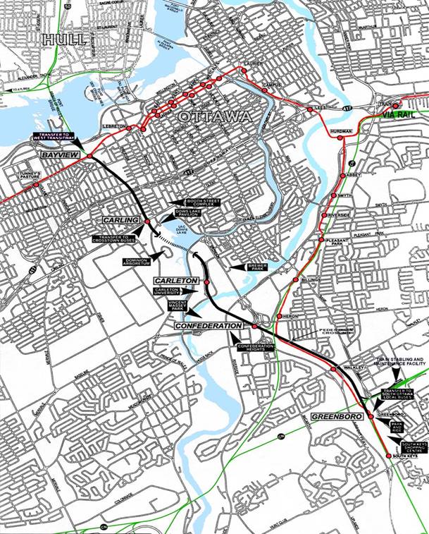
http://www.ottawa.ca/calendar/ottawa/cit...-TRA-0013%20Otrain%20business%20case.htm

Significant upgrades to the O-Train line planned.

However, wouldn't it be more effective to purchase, say, 5 or 6 new Talent or compatible trains and refurbish the existing 3 trains? That would also allow for 8-9 trains to be available, allowing for extensions of the O-Train line.

I would fund for 2013 the extension to Gatineau as well by refurbishing the Prince of Wales bridge and a passing track on Lemieux Island. That would eliminate the need to run Route 40 to Gatineau with a faster route available and reduce - but by no means eliminate - the need for Route 105 buses (Route 8 would remain unchanged). Such would require at least a 5th train in addition to frequency improvements.

Two other stations should be added near Gladstone Avenue and Walkley Road. Gladstone may need to be dual-platform based on the proposed location for the passing track.

I would also consider for 2013, an extension to Hunt Club Loop and a new station between South Keys and Lester Road (it is 2.2 km between South Keys and Lester Road so an intermediate station would be warranted anyway). Extending to west of Hunters Point (~900m south of South Keys) would require a 6th train in revenue service at once based on the official plans. Since the tracks and Hunt Club underpass are already in place, that extension should be cheap. That would greatly improve access to the Bridle Path Drive area including a high-density residential area.

If deemed cost-effective, in 2014-15 (could be done without closing the existing route since it could be adjacent with the current location preserved for twinning), a grade separation of the VIA tracks should also be considered to eliminate the need to freeze the system temporarily.

Passing tracks, at this stage, would be needed during busy times (daytime on weekdays):

1 - On Lemieux Island (connecting track sections 1 and 2) - Additional with bridge reconstruction
2 - Between Bayview and Carling (sections 2 and 3) - Planned
3 - Carleton Station (sections 3 and 4)
4 - Between Confederation and Walkley (sections 4 and 5) - Planned
5 - Between Greenboro and South Keys (sections 5 and 6) - Additional

Using 6 trains, the frequency of 8 minutes would require 6 trains in service during peak periods and midday on weekdays. During less-busy times (generally evenings and weekends), 3 trains would be needed at once for a 15 minute frequency. At the least busy times (late evenings and Sunday mornings), 25 minute service would be provided with two trains passing at Carleton.
Reply With Quote
     
     
  #3992  
Old Posted Jun 10, 2011, 4:01 PM
McC's Avatar
McC McC is offline
Registered User
 
Join Date: Apr 2010
Posts: 3,057
I like this proposal much more than your western LRT proposal
Reply With Quote
     
     
  #3993  
Old Posted Jun 10, 2011, 4:02 PM
eternallyme eternallyme is offline
Registered User
 
Join Date: Mar 2009
Posts: 5,243
Quote:
Originally Posted by McC View Post
I like this proposal much more than your western LRT proposal
Yeah, I might need to rework my proposal based on all your thoughts, or see other proposals. After the critique, there is no way I am submitting that proposal as it stands.
Reply With Quote
     
     
  #3994  
Old Posted Jun 10, 2011, 4:12 PM
eternallyme eternallyme is offline
Registered User
 
Join Date: Mar 2009
Posts: 5,243
If my idea for the existing O-Train line upgrades comes true, some bus route adjustments in 2013 that would be ideal:

1 - I proposed extending it down to Blossom Park along Bank, and continue to recommend such. That would provide a downtown link - all day - that avoids the Transitway completely (albeit not a fast link).

40 - Eliminate route. A Gatineau link is already provided (much faster) and downtown access would be cut off and likely quicker via the O-Train.

43 - Eliminate route. Renumber all trips as Route 143 trips. (I proposed the 143 be eliminated this year; maintaining the proposal would make the 143 a peak-only route with a re-routed 114 providing all-day service in the area.) Since the Transitway will be cut off, the number of buses on that corridor need to be reduced. An enhanced O-Train will accomodate such.

105 - Reduce the number of trips, as many will be coming from the O-Train which would be within walking distance (ideally, the station would be where the residual double track parallel to Tache is).

142 - Resurrect as a peak-only route on the same routing that Route 40 will run in September to Hurdman initially, then the temporary relocation afterward. Such will be aimed at those going at other non-downtown destinations or having to transfer eastward.

143 - Renumber all Route 43 trips as 143, and extend to Hurdman initially, then the temporary relocation afterward.

144 - Make minor adjustments during peak periods to avoid duplication with Route 142 and keep farther from the O-Train during peak periods.

Money savings would be found by shortening the 40/142 and 43/143 and reducing the number of 105s. It may be possible to reduce the number of 97s as well to a 10-12 minute frequency by eliminating the short runs and extending the 99 (the combined 97/98/99 would have to run at least every 4-5 minutes though most of the day)
Reply With Quote
     
     
  #3995  
Old Posted Jun 11, 2011, 3:33 PM
waterloowarrior's Avatar
waterloowarrior waterloowarrior is offline
National Capital Region
 
Join Date: Nov 2005
Location: Eastern Ontario
Posts: 9,254
from EM's link...

Quote:
Recognizing the parameters above, and the Business Plan commitments, this report recommends an approach to expanding O-Train service that meets short and mid-term needs related to service frequency and capacity, while providing service comparable to the planned electric north-south light rail line (Bayview to South Keys) by 2014, a decade earlier than previously planned. It would also permit the potential extension of high-frequency light rail service south of Greenboro Station without the need for electrification, even though doing so would preclude some benefits of electrification including the potential for better urban integration at stations.

This report discusses the following key elements of the O-Train service expansion proposal:
  • Acquisition of six new diesel multiple-unit (DMU) trains to permit concurrent operation of four trains in peak periods, with two spare trains (including one “hot spare” ready to enter service if needed), beginning in 2014;
  • Construction of two new passing tracks and signalling infrastructure along the O-Train line at Gladstone Avenue and south of Brookfield pedestrian pathway crossing (see Figure 1);
  • An increase in peak service frequency from 15 minutes to approximately 8 minutes (which is lower than the 10‑minute frequency estimate in the 2011 Business Plan), yielding an increase in peak capacity of at least 80% (from 1,100 to over 2,000 passengers per hour in each direction—a further increase from 1,800 customers per hour in each direction estimated in the Business Plan);
  • Upgraded O-Train station facilities to improve accessibility and customer convenience; and
  • Expanded and upgraded maintenance facilities to accommodate the larger DMU fleet.
Reply With Quote
     
     
  #3996  
Old Posted Jun 11, 2011, 6:41 PM
McC's Avatar
McC McC is offline
Registered User
 
Join Date: Apr 2010
Posts: 3,057
Quote:
Originally Posted by waterloowarrior View Post
from EM's link...


so Walkley and SoKeys would get stations (good) and Gladstone wouldn't?

EDIT: never mind, I guess I misread those SE Transitway station dots.
Reply With Quote
     
     
  #3997  
Old Posted Jun 12, 2011, 4:54 PM
Richard Eade Richard Eade is offline
Registered User
 
Join Date: Mar 2008
Location: Nepean
Posts: 2,651
Recently I have been thinking about the Hurdman Station and whether there would be an easy way to get more buses through that station. I spent some time watching how well the buses flow through the station during the afternoon peak period and I was impressed that it works as well as it does. There are times when a line of five or six buses from the east can build at the all-way stop to the east of the station, but that is more the exception; and the backlog seems to clear up within minutes. This surprised me a bit since I had heard stories about how over-loaded the Hurdman station was and how the central platform tied the buses up in knots. What I saw was a very busy station, but not a failing one. On the west end, there seems to be a steady flow, but nothing in the way of a back-up was seen.

That said, the intersection on the east end does get backed up a bit every now and again. Every bus must stop at the four-way intersection, plus, this is the only pedestrian crossing facility to the station from any direction. There are also a good number of ‘Out of Service’ buses using the East and South-East Transitways for relocations so they also pass through this intersection; as well as buses coming out of the Hurdman bus lay-up.

Figure 1: Hurdman Station's existing configuration (facing south)


Because the station has a central platform, the all buses must cross the opposing stream when arriving at and departing from the Station. Also, with this intersection being the only pedestrian access to the station, there are times when buses from all directions must wait while people cross up to three bus lanes.

These access issues are unavoidable without a complete reconfiguration of the station. I am wondering, though, if splitting up functions could lead to smoother bus operations into and out of Hurdman Station. Specifically, I suggest moving the east-bound buses away from the intersection at the east end of the station and routing them along the north of the bus lay-up area to the intersection of the Eastern Transitway and the extension of Industrial Avenue.

Figure 2: Hurdman Station - Rerouted (facing south)


In the diagram, the blue lines represent the path of west-bound buses and the red lines are for east-bound buses. I have also changed the pedestrian path north of the station (shown in grey) so that pedestrians arrive directly at the station and are not required to cross at the busy intersection. By moving the east-bound buses to the south of the bus lay-up area, they no longer go through the east intersection. In fact, it might be possible to have buses from the east travel right through the intersection with yield signs on the South-East Transitway arms. Although this idea is not shown in the diagram, it would speed up buses going from east to west; including those from the Lay-up area.

Also, I have removed the right-turn at this intersection for buses heading south to go back to the south platform. As far as I know, there are no ‘in service’ buses which circle the platform’s east end so I suggest that any bus which needs to go from the north side of the platform to the south side would loop around the Operator facilities island. The only turning buses at this intersection will be those coming from the north-bound South-East Transitway into the station, and those ‘out of service’ buses turning from the Eastern Transitway to go south on the South-East Transitway, by-passing Hurdman Station.

Because Hurdman Station is still a central platform station, the buses must still cross the opposing path as they arrive and leave. In this design, some of those crossings would move east to their own dedicated intersection which is clear of other obstacles – such as pedestrians. In this suggestion, the east-bound buses would not be required to stop (as indicated by the solid red lines); the west-bound buses would yield to them. I chose this configuration because the majority of the west-bound buses are coming down the slope of the Transitway and would have an easier time of accelerating from the stop. Notice that I am suggesting YIELD signs so that none of the buses need to stop if the way is clear; perhaps sensors and signal lights can be used to help guide the bus Operators.

Figure 3: Modified dedicated intersection with Industrial Avenue (facing south)


You will notice that west-bound buses from Industrial Avenue and Terminal Avenue will likely still need to stop if an east-bound bus is visible since it might be difficult to know if that east-bound bus is heading for the Eastern Transitway (turning left) or Industrial Avenue (continuing straight). In theory, if the direction of the east-bound bus were clear, then west-bound buses from Industrial Avenue and buses bound for the Eastern Transitway could mutually turn left without interference or delay; i.e., there would be no need for the west-bound bus to yield.

In order to ensure that this condition could be met more often, it might be possible to CONTRA-FLOW the short extension of Industrial Avenue.

Figure 4: Contra-flow buses along the Industrial Avenue extension (facing south)


The design of the traffic islands at the intersection of the Eastern Transitway and the Industrial Avenue extension would make it very clear for bus Operators which lane to follow; there could be no mix-up to enter the wrong direction lane. At the intersection of Terminal Avenue and the Industrial Avenue extension, there would need to be sufficient signage to prevent confusion and bus Operators would need proper training. Since there are no pedestrians at either of these intersections, the risk of danger to people is quite low. There would also need to be good signage for those vehicles accessing the pumping station.

In summary, the east-bound buses are removed from the intersection at the east end of Hurdman Station and the pedestrians are restricted to only cross at two locations. By moving the east-bound buses away, the number of lanes that the pedestrians must cross is reduced to two; making for less of a delay for the buses. Also, buses from the east might need to only yield to pedestrians; with the lower volume of buses on the South-East Transitway yielding to the buses from the east. Many buses would not need to completely stop at this intersection which could improve bus throughput. In addition, by not forcing every bus to stop there, the level of noise may be reduced for the neighbouring residential tower.

The pathway to the north of the station is modified so that it provides better direct access directly to the station, and guides people to the approved side of the intersection to cross.

The east-bound and west-bound buses would still need to cross paths, but would do so at the dedicated intersection of the Eastern Transitway and the Industrial Avenue extension. Again, to speed the operation, not all buses would be required to stop. In fact, the east-bound buses would have priority and not be required to stop at all. The west-bound buses would yield as required. If the west-bound buses were becoming backed up, an east-bound bus could stop and allow the west-bound buses to clear the intersection, although this should not be necessary since there should be adequate breaks in the east-bound bus stream. Buses arriving at the station from the Eastern or South-East Transitways seem to do so with gaps between buses.

By changing the bus-only extension of Industrial Avenue to have the buses drive on the left (contra-flow), buses from that route would not be interrupted at all by east-bound buses.

Although not specifically shown by the blue lines, where ever buses are merging together, for example, immediately south of the Eastern Transitway and Industrial Avenue extension intersection, there would be twined lanes for a distance to ensure smooth merging.

At this point, I don’t think there is an issue with the buses crossing at the west end of the station; although I’d like to try giving the west-bound buses a clear path, with the buses arriving at the station yielding to them, instead of the two-way stop. There should also be no right-turns (at the west end of the platform) at the same intersection that east-bound buses are crossing; all buses should go straight through the intersection and then there can be a ramp to turn back.

Figure 5: West intersection changes are optional (facing south)


Not shown explicitly, there would be a YIELD sign for the east-bound buses.

Alternatively, the buses which are looping around the west end of the station can be removed before the east-bound buses would need to yield to them. This would mean fewer buses to yield to for the east-bound buses.

Figure 6: Alternative optional west end changes (facing south)


So that is my current thinking about Hurdman Station: Do you think it would help the bus flow into and out of the station?

Reply With Quote
     
     
  #3998  
Old Posted Jun 12, 2011, 6:37 PM
eternallyme eternallyme is offline
Registered User
 
Join Date: Mar 2009
Posts: 5,243
Quote:
Originally Posted by Richard Eade View Post
Recently I have been thinking about the Hurdman Station and whether there would be an easy way to get more buses through that station. I spent some time watching how well the buses flow through the station during the afternoon peak period and I was impressed that it works as well as it does. There are times when a line of five or six buses from the east can build at the all-way stop to the east of the station, but that is more the exception; and the backlog seems to clear up within minutes. This surprised me a bit since I had heard stories about how over-loaded the Hurdman station was and how the central platform tied the buses up in knots. What I saw was a very busy station, but not a failing one. On the west end, there seems to be a steady flow, but nothing in the way of a back-up was seen.

That said, the intersection on the east end does get backed up a bit every now and again. Every bus must stop at the four-way intersection, plus, this is the only pedestrian crossing facility to the station from any direction. There are also a good number of ‘Out of Service’ buses using the East and South-East Transitways for relocations so they also pass through this intersection; as well as buses coming out of the Hurdman bus lay-up.

Figure 1: Hurdman Station's existing configuration (facing south)


Because the station has a central platform, the all buses must cross the opposing stream when arriving at and departing from the Station. Also, with this intersection being the only pedestrian access to the station, there are times when buses from all directions must wait while people cross up to three bus lanes.

These access issues are unavoidable without a complete reconfiguration of the station. I am wondering, though, if splitting up functions could lead to smoother bus operations into and out of Hurdman Station. Specifically, I suggest moving the east-bound buses away from the intersection at the east end of the station and routing them along the north of the bus lay-up area to the intersection of the Eastern Transitway and the extension of Industrial Avenue.

Figure 2: Hurdman Station - Rerouted (facing south)


In the diagram, the blue lines represent the path of west-bound buses and the red lines are for east-bound buses. I have also changed the pedestrian path north of the station (shown in grey) so that pedestrians arrive directly at the station and are not required to cross at the busy intersection. By moving the east-bound buses to the south of the bus lay-up area, they no longer go through the east intersection. In fact, it might be possible to have buses from the east travel right through the intersection with yield signs on the South-East Transitway arms. Although this idea is not shown in the diagram, it would speed up buses going from east to west; including those from the Lay-up area.

Also, I have removed the right-turn at this intersection for buses heading south to go back to the south platform. As far as I know, there are no ‘in service’ buses which circle the platform’s east end so I suggest that any bus which needs to go from the north side of the platform to the south side would loop around the Operator facilities island. The only turning buses at this intersection will be those coming from the north-bound South-East Transitway into the station, and those ‘out of service’ buses turning from the Eastern Transitway to go south on the South-East Transitway, by-passing Hurdman Station.

Because Hurdman Station is still a central platform station, the buses must still cross the opposing path as they arrive and leave. In this design, some of those crossings would move east to their own dedicated intersection which is clear of other obstacles – such as pedestrians. In this suggestion, the east-bound buses would not be required to stop (as indicated by the solid red lines); the west-bound buses would yield to them. I chose this configuration because the majority of the west-bound buses are coming down the slope of the Transitway and would have an easier time of accelerating from the stop. Notice that I am suggesting YIELD signs so that none of the buses need to stop if the way is clear; perhaps sensors and signal lights can be used to help guide the bus Operators.

Figure 3: Modified dedicated intersection with Industrial Avenue (facing south)


You will notice that west-bound buses from Industrial Avenue and Terminal Avenue will likely still need to stop if an east-bound bus is visible since it might be difficult to know if that east-bound bus is heading for the Eastern Transitway (turning left) or Industrial Avenue (continuing straight). In theory, if the direction of the east-bound bus were clear, then west-bound buses from Industrial Avenue and buses bound for the Eastern Transitway could mutually turn left without interference or delay; i.e., there would be no need for the west-bound bus to yield.

In order to ensure that this condition could be met more often, it might be possible to CONTRA-FLOW the short extension of Industrial Avenue.

Figure 4: Contra-flow buses along the Industrial Avenue extension (facing south)


The design of the traffic islands at the intersection of the Eastern Transitway and the Industrial Avenue extension would make it very clear for bus Operators which lane to follow; there could be no mix-up to enter the wrong direction lane. At the intersection of Terminal Avenue and the Industrial Avenue extension, there would need to be sufficient signage to prevent confusion and bus Operators would need proper training. Since there are no pedestrians at either of these intersections, the risk of danger to people is quite low. There would also need to be good signage for those vehicles accessing the pumping station.

In summary, the east-bound buses are removed from the intersection at the east end of Hurdman Station and the pedestrians are restricted to only cross at two locations. By moving the east-bound buses away, the number of lanes that the pedestrians must cross is reduced to two; making for less of a delay for the buses. Also, buses from the east might need to only yield to pedestrians; with the lower volume of buses on the South-East Transitway yielding to the buses from the east. Many buses would not need to completely stop at this intersection which could improve bus throughput. In addition, by not forcing every bus to stop there, the level of noise may be reduced for the neighbouring residential tower.

The pathway to the north of the station is modified so that it provides better direct access directly to the station, and guides people to the approved side of the intersection to cross.

The east-bound and west-bound buses would still need to cross paths, but would do so at the dedicated intersection of the Eastern Transitway and the Industrial Avenue extension. Again, to speed the operation, not all buses would be required to stop. In fact, the east-bound buses would have priority and not be required to stop at all. The west-bound buses would yield as required. If the west-bound buses were becoming backed up, an east-bound bus could stop and allow the west-bound buses to clear the intersection, although this should not be necessary since there should be adequate breaks in the east-bound bus stream. Buses arriving at the station from the Eastern or South-East Transitways seem to do so with gaps between buses.

By changing the bus-only extension of Industrial Avenue to have the buses drive on the left (contra-flow), buses from that route would not be interrupted at all by east-bound buses.

Although not specifically shown by the blue lines, where ever buses are merging together, for example, immediately south of the Eastern Transitway and Industrial Avenue extension intersection, there would be twined lanes for a distance to ensure smooth merging.

At this point, I don’t think there is an issue with the buses crossing at the west end of the station; although I’d like to try giving the west-bound buses a clear path, with the buses arriving at the station yielding to them, instead of the two-way stop. There should also be no right-turns (at the west end of the platform) at the same intersection that east-bound buses are crossing; all buses should go straight through the intersection and then there can be a ramp to turn back.

Figure 5: West intersection changes are optional (facing south)


Not shown explicitly, there would be a YIELD sign for the east-bound buses.

Alternatively, the buses which are looping around the west end of the station can be removed before the east-bound buses would need to yield to them. This would mean fewer buses to yield to for the east-bound buses.

Figure 6: Alternative optional west end changes (facing south)


So that is my current thinking about Hurdman Station: Do you think it would help the bus flow into and out of the station?

Because it is a central platform, it is almost impossible without a major reconstruction to avoid a double-crossover. 2 and 6 seem like the most reasonable short-term modifications though.

Ultimately, Hurdman should become an LRT junction and only a small local platform would be necessary (or even on-street connections if my vision of the area - a satellite downtown area with the real tallest buildings while maintaining a strict height limit on new buildings in the current core area (no more buildings taller than the bottom of the clock of the Peace Tower) - becomes reality.)
Reply With Quote
     
     
  #3999  
Old Posted Jun 12, 2011, 6:50 PM
MalcolmTucker MalcolmTucker is offline
Registered User
 
Join Date: May 2007
Posts: 11,618
After the LRT is in place, shouldn't volumes fall enough that the needs for reconfiguration become moot?
Reply With Quote
     
     
  #4000  
Old Posted Jun 13, 2011, 3:45 AM
Richard Eade Richard Eade is offline
Registered User
 
Join Date: Mar 2008
Location: Nepean
Posts: 2,651
Yes, this would be a temporary change, only needed until the station is reconfigured for the LRT. The problem is that that could be five or so years away (2016-17) and bus traffic keeps growing. There are conflicting views as to when Hurdman Station will be taken ‘Off-line’ for buses; OC Transpo is explaining the need for increased O-Trains on handling the passenger load when Hurdman is taken out of service (presumable in 2013 when the new train-sets are delivered); while the Rail Implementation Office (RIO) is saying that they hope to maintain Hurdman Station and the bridge across the Rideau River as long as possible (maybe 2016-17) while the new Hurdman Station is build north of the existing station. At this point, it is unclear whether any bus changes to Hurdman Station will be needed or justified.

That said, I agree with eternallyme that the buses will need to cross at each end of Hurdman Station; the question is whether such an arrangement could be made more efficient by dividing the bus crossings. For the most part, the suggestions I have made do not eliminate the crossings, but they allow the interactions to take place only when necessary; that is, for the most part, the buses should be able to cross without having to stop at an all-way stop intersection.

OC Transpo is continually saying that Hurdman Station is in need of modification to help buses get through it faster. Changes are pending, but I do not know what is planned. Whatever changes are made will need to be very inexpensive since it would be a waste to put much money into a station which is slated to be replaced within 7 years. This is why my suggestions tried to follow existing paved areas with only small ‘hard infrastructure’ changes. I would be tempted to put off any changes to the western crossing while moving the east-bound buses to the north of the lay-up area, as in Figure 2. I would suggest that Figure 4 be implemented to minimize the delays for buses crossing at the intersection of the Eastern Transitway and the extension of Industrial Avenue. Anyway, I expect this is more a mind exercise that what can really happen but I was wondering if it would have any positive affect.

Yes, once the LRT is up and running, Hurdman will simply become a transfer station for people connecting to/from the South-East Transitway; this, will however amount to a large number of people transferring to the trains. The buses arriving will circle around an island and the platform will be on the outside, north of the loop, so no more bus crossing. Yes, the volume of buses should be lower, but hopefully the volume of passengers through the station will increase.
Reply With Quote
     
     
This discussion thread continues

Use the page links to the lower-right to go to the next page for additional posts
 
 
Reply

Go Back   SkyscraperPage Forum > Regional Sections > Canada > Ontario > Ottawa-Gatineau > Transportation
Forum Jump


Forum Jump


All times are GMT. The time now is 9:19 AM.


Powered by vBulletin® Version 3.8.7
Copyright ©2000 - 2026, vBulletin Solutions, Inc.